
| BARTOW MUNI BARTOW FL |
| |
| Lat: N 2756.6 Long: W 08147.0 Elev: 125 Var: +04 Longest Runway: 5001 | ||
| AWOS: 123.77 Ground: 121.9 Tower: 121.2 | ||
| ||||||||||||||||||||||||||||||||||||||||||||
| ||||||||||||||||||||||||||||||||||||||||||||
| ||||||||||||||||||||||||||||||||||||||||||||
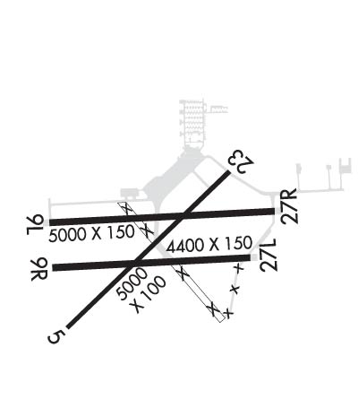
| Rwy | Rwy | |||||||
| 5001x100 | 5001' | 5001x100 | 5001' | |||||
| 5000x150 | 5000' | 5000x150 | 5000' | |||||
| 4416x150 | 4416' | 4416x150 | 4416' | |||||
| Runway ID | Single Wheel | Double Wheel | Double Tandem Wheel | Dual Double Wheel |
| 05/23 | 35,000 | 60,000 | 110,000 | N/A |
| 09L/27R | N/A | N/A | N/A | N/A |
| 09R/27L | N/A | N/A | N/A | N/A |
| These numbers are Advisory and are not limits. The Airport Manager should have more accurate Weight Limits | ||||
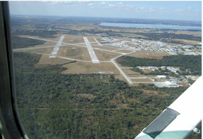
 Airport Diagram might not be current. | |
| Facility Name: | BARTOW EXEC |
| City Name: | BARTOW |
| County: | POLK |
| State abbrev: | FL |
| State Name: | FLORIDA |
| Ownership: | PUBLICLY OWNED |
| Use: | OPEN TO THE PUBLIC |
| Owner's Name: | BARTOW MUNI ARPT DVLPMNT AUTH |
| Address: | PO BOX 650 |
| BARTOW, FL 33831-0650 | |
| Owner's Phone: | 863-533-1195 |
| Manager's Name: | JOHN B. HELMS, II |
| Address: | 5993 AIRPORT BLVD |
| BARTOW, FL 33830 | |
| Phone: | 863-533-1195 |
| FAA Region: | SOUTHERN |
| FAA Field Office: | ORL |
| Date | Sunrise | Sunset |
|---|---|---|
| 04/24/24 Wednesday | 6:53 | 19:58 |
| 04/25/24 Thursday | 6:52 | 19:58 |
| 04/26/24 Friday | 6:51 | 19:59 |
| 04/27/24 Saturday | 6:50 | 20:00 |
| 04/28/24 Sunday | 6:49 | 20:00 |
| 04/29/24 Monday | 6:48 | 20:01 |
| 04/30/24 Tuesday | 6:48 | 20:01 |
| 05/01/24 Wednesday | 6:47 | 20:02 |
| 05/02/24 Thursday | 6:46 | 20:03 |
| 05/03/24 Friday | 6:45 | 20:03 |
| 05/04/24 Saturday | 6:44 | 20:04 |
| 05/05/24 Sunday | 6:44 | 20:04 |
| 05/06/24 Monday | 6:43 | 20:05 |
| 05/07/24 Tuesday | 6:42 | 20:05 |
| Airport Attendance Schedule | 7 Days A Week 0600-1800; UNATTND EASTER, INDEPENDANCE DAY, THANKSGIVING & CHRISTMAS. |
| Airport Status | OPERATIONAL (This Status can change at any time - please check NOTAMS) |
| Airport Lighting Schedule | ACTVT REILS RWY 05, 09L, 23 & 27R; PAPI RWYS 05, 09L, 23, & 27R; MIRL RWYS 05/23 & 09L/27R; AND WIND CONE - CTAF. REIL RWYS 05, 09L, 23 & 27R OPER WHEN MIRL RWYS 05/23 & 09L/27R HIGH INTST ONLY. |
| Airport Storage Available | Tie Downs, Hanger |
| Extra Services Available | Air Ambulance, Avionics, Flight Instruction, Aircraft Rental, Aircraft Sales, Annual Surveying |
| Wind Indicator | YES - (lighted) |
| Control Tower | YES |
| CTAF Frequency | 121.200 |
| Unicom Frequency | 122.950 |
| Rotating Beacon Color | WG |
| Segmented Circle | Y-L |
| Landing Fee | NO |
| Airport Inspected | STATE - performed by STATE AERONAUTICAL PERSONNEL |
| Inspection Date | 07/24/2018 |
| Type of Fuel Available | Grade 100LL, JET A (freeze point -40C); -10100LL AVBL 24 HRS WITH CREDIT CARD. |
| Airframe Repair Service | MAJOR |
| Power Plant Repair Service | MAJOR |
| Latitude | N2756.6 |
| Longitude | W08147.0 (ESTIMATED) |
| Arpt Elevation | 124ft (SURVEYED) |
| Magnetic Variation | 04W |
| 4 miles NE | of BARTOW |
| Traffic Pattern Altitude | |
| Sectional Chart | MIAMI |
| Operations (Reported) | Yearly | Avg. Daily |
|---|---|---|
| General Aviation Transient | 42253 | 116 |
| General Aviation Local | 20207 | 55 |
| Air Taxi | 1515 | 4 |
| Commerical | 0 | 0 |
| Commuter | 0 | 0 |
| Military | 57 | 0 |
| Aircraft based on Field | |
|---|---|
| General Aviation Singles | 109 |
| General Aviation Multi | 13 |
| Jet Aircraft | 4 |
| General Aviation Helicopters | 8 |
| Military Aircraft | 0 |
| Gliders | 1 |
| Ultralights | 0 |
| FSS on field | NO |
| FSS tie-in | SAINT PETERSBURG |
| FSS Phone | 1-800-WX-BRIEF |
| Who issues Notams | BOW |
| Notam D service at airport | YES |
| ARTCC Name | MIAMI |
| Airport Certification | |
| Aircraft Rescue & Firefighting Index | None |
| Airport of Entry | No |
| Custom Landing Rights | No |
| Joint Civil/Military | No |
| Military Landing rights | YES |
| NATIONAL PLAN OF INTEGRATED AIRPORT SYSTEMS (NPIAS) |
| GRANT AGREEMENTS UNDER FAAP/ADAP/AIP |
| SURPLUS PROPERTY AGREEMENT UNDER PUBLIC LAW 289 |
| SURPLUS PROPERTY AGREEMENT UNDER REGULATION 16-WAA |
| ASSURANCES PURSUANT TO TITLE VI, CIVIL RIGHTS ACT OF 1964 |
| AGREEMENT UNDER DLAND OR DCLA HAS EXPIRED. |
| OVERHEAD PLINES IN T-HANGAR AREA - APPROX 20' VERTICAL CLEARANCE. |
| WILDLIFE INVOF ARPT. |
| WHEN ATCT CLSD, FOR CD CTC TAMPA APCH AT 813-878-2528 |
| RWY 05/2 3 CRACKING THRUT RWY 05/23. |
| RWY 09R/ 27LRWY 09R/27L PRODUCING LOOSE AGGREGATE IN SOME AREAS. |
| RWY 09R/ 27LRWY 27L CONC 1ST 300 FT. |
Airport Communications & Frequencies:
| |||||||||||||||||||||||||||||
| Runway: 05 | Runway: 23 | ||
| Mag heading: | 50° | Mag heading: | 230° |
| Rwy Slope: | .29% Up | Rwy Slope: | -.29% Down |
| Approach: | Approach: | ||
| Pattern: | Left Traffic | Pattern: | Left Traffic |
| Markings: | NONPRECISION INSTRUMENT | Markings: | NONPRECISION INSTRUMENT |
| Marking Condition: | GOOD | Marking Condition: | GOOD |
| Arresting Dev: | Arresting Dev: | ||
| Lat & Long: | N2756.3 W08147.4 | Lat. & Long.: | N2756.9 W08146.7 |
| Elev: | 107.9 ft. MSL | Elev: | 122.2 ft. MSL |
| TCH: | 51 ft. AGL | TCH: | 48 ft. AGL |
| Visual Glide Path: | 3.50 degrees | Visual Glide Path: | 3.50 degrees |
| Displaced Threshold: | No | Displaced Threshold: | No |
| Touchdown Zone: | YES | Touchdown Zone: | YES |
| Touchdown Elev.: | 123.4 feet | Touchdown Elev.: | 124.0 feet |
| Visual Glide Slope: | 4-Light PAPI on LEFT side of Runway | Visual Glide Slope: | 4-Light PAPI on LEFT side of Runway |
| RVR Equipment: | RVR Equipment: | ||
| RVV Equipment: | NO | RVV Equipment: | NO |
| Approach Lights: | Approach Lights: | ||
| REIL: | YES | REIL: | YES |
| Centerline Lights: | NO | Centerline Lights: | NO |
| Touchdown lights: | NO | Touchdown lights: | NO |
| Runway Category: | Runway with a Non-precision Approach having visibility minimums greater than 3/4 mile | Runway Category: | Runway with a Non-precision Approach having visibility minimums greater than 3/4 mile |
| Declared Distances: | Declared Distances: | ||
| Obstructions: | TREES | Obstructions: | TREES |
| Marked: | NOT Marked/Lighted | Marked: | NOT Marked/Lighted |
| Clearance slope: | 36:1 | Clearance slope: | 32:1 |
| Obstruction height: | 33 feet AGL | Obstruction height: | 45 feet AGL |
| Dist. from runway: | 1380 feet | Dist. from runway: | 1620 feet |
| Centerline offset: | 250 left of centerline | Centerline offset: | 250 feet left of centerline |
| Comments: | Comments: |
| Runway: 09L | Runway: 27R | ||
| Mag heading: | 91° | Mag heading: | 271° |
| Rwy Slope: | -.05% Down | Rwy Slope: | .05% Up |
| Approach: | Approach: | ||
| Pattern: | Left Traffic | Pattern: | Left Traffic |
| Markings: | NONPRECISION INSTRUMENT | Markings: | NONPRECISION INSTRUMENT |
| Marking Condition: | GOOD | Marking Condition: | GOOD |
| Arresting Dev: | Arresting Dev: | ||
| Lat & Long: | N2756.7 W08147.4 | Lat. & Long.: | N2756.7 W08146.5 |
| Elev: | 116.9 ft. MSL | Elev: | 114.5 ft. MSL |
| TCH: | 46 ft. AGL | TCH: | 34 ft. AGL |
| Visual Glide Path: | 3.00 degrees | Visual Glide Path: | 3.00 degrees |
| Displaced Threshold: | No | Displaced Threshold: | No |
| Touchdown Zone: | YES | Touchdown Zone: | YES |
| Touchdown Elev.: | 124.6 feet | Touchdown Elev.: | 124.6 feet |
| Visual Glide Slope: | 4-Light PAPI on LEFT side of Runway | Visual Glide Slope: | 4-Light PAPI on LEFT side of Runway |
| RVR Equipment: | RVR Equipment: | ||
| RVV Equipment: | NO | RVV Equipment: | NO |
| Approach Lights: | Approach Lights: | ||
| REIL: | YES | REIL: | YES |
| Centerline Lights: | NO | Centerline Lights: | NO |
| Touchdown lights: | NO | Touchdown lights: | NO |
| Runway Category: | Runway with a Non-precision Approach having visibility minimums greater than 3/4 mile | Runway Category: | Runway with a Non-precision Approach having visibility minimums greater than 3/4 mile |
| Declared Distances: | Declared Distances: | ||
| Obstructions: | TREE | Obstructions: | TREE |
| Marked: | NOT Marked/Lighted | Marked: | NOT Marked/Lighted |
| Clearance slope: | 34:1 | Clearance slope: | 34:1 |
| Obstruction height: | 62 feet AGL | Obstruction height: | 28 feet AGL |
| Dist. from runway: | 2290 feet | Dist. from runway: | 1130 feet |
| Centerline offset: | 110 right of centerline | Centerline offset: | 240 feet left of centerline |
| Comments: | Comments: |
| Runway: 09R | Runway: 27L | ||
| Mag heading: | 91° | Mag heading: | 271° |
| Rwy Slope: | -.02% Down | Rwy Slope: | .02% Up |
| Approach: | Approach: | ||
| Pattern: | Left Traffic | Pattern: | Left Traffic |
| Markings: | BASIC | Markings: | BASIC |
| Marking Condition: | GOOD | Marking Condition: | GOOD |
| Arresting Dev: | Arresting Dev: | ||
| Lat & Long: | N2756.5 W08147.4 | Lat. & Long.: | N2756.5 W08146.6 |
| Elev: | 112.3 ft. MSL | Elev: | 111.6 ft. MSL |
| TCH: | TCH: | ||
| Visual Glide Path: | Visual Glide Path: | ||
| Displaced Threshold: | No | Displaced Threshold: | No |
| Touchdown Zone: | YES | Touchdown Zone: | YES |
| Touchdown Elev.: | 119.9 feet | Touchdown Elev.: | 119.9 feet |
| Visual Glide Slope: | Visual Glide Slope: | ||
| RVR Equipment: | RVR Equipment: | ||
| RVV Equipment: | NO | RVV Equipment: | NO |
| Approach Lights: | Approach Lights: | ||
| REIL: | NO | REIL: | NO |
| Centerline Lights: | NO | Centerline Lights: | NO |
| Touchdown lights: | NO | Touchdown lights: | NO |
| Runway Category: | Runway with a Visual Approach | Runway Category: | Runway with a Visual Approach |
| Declared Distances: | Declared Distances: | ||
| Obstructions: | TREES | Obstructions: | TREES |
| Marked: | NOT Marked/Lighted | Marked: | NOT Marked/Lighted |
| Clearance slope: | 31:1 | Clearance slope: | 20:1 |
| Obstruction height: | 56 feet AGL | Obstruction height: | 40 feet AGL |
| Dist. from runway: | 1900 feet | Dist. from runway: | 1000 feet |
| Centerline offset: | 175 left of centerline | Centerline offset: | 30 feet right of centerline |
| Comments: | Comments: |
Thanks for using FltPlan.com
all rights reserved © 1999-2024 by Flight Plan LLC