
| GENERAL EDWARD LAWRENCE LOGAN BOSTON MA |
| |
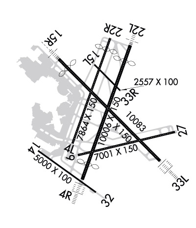
| Lat: N 4221.8 Long: W 07100.4 Elev: 19 Var: +15 Longest Runway: 10083 | ||
| Clr Del: 121.65 Dept. ATIS: 135.0 Arr. ATIS: 135.0 Ground: 121.9/121.75 Tower: 132.22/128.8 | ||
| ||||||||||||||||||||||||||||||||||||||||||||
| ||||||||||||||||||||||||||||||||||||||||||||
| ||||||||||||||||||||||||||||||||||||||||||||
| ||||||||||||||||||||||||||||||||||||||||||||
| Rwy | Rwy | |||||||
| 7864x150 | 7864' | 7864x150 | 7045' | |||||
| 10006x150 | 8851' | 110.30 - 034° | 10006x150 | 8807' | 110.30 - 214° | |||
| 7001x150 | 7001' | 7001x150 | 7001' | 111.30 - 271° | ||||
| 5000x100 | 5000' | 5000x100 | 5000' | |||||
| 2557x100 | 2557' | 2557x100 | 2557' | |||||
| 10083x150 | 9201' | 110.70 - 148° | 10083x150 | 10083' | 110.70 - 331° | |||
| Runway ID | Single Wheel | Double Wheel | Double Tandem Wheel | Dual Double Wheel |
| 04L/22R | 120,000 | 250,000 | 550,000 | N/A |
| 04R/22L | 120,000 | 250,000 | 550,000 | N/A |
| 09/27 | 120,000 | 250,000 | 550,000 | N/A |
| 14/32 | 120,000 | 250,000 | 490,000 | N/A |
| 15L/33R | 120,000 | 250,000 | 550,000 | N/A |
| 15R/33L | 120,000 | 250,000 | 550,000 | N/A |
| These numbers are Advisory and are not limits. The Airport Manager should have more accurate Weight Limits | ||||
 Airport Diagram might not be current. | |
| Facility Name: | GENERAL EDWARD LAWRENCE LOGAN INTL |
| City Name: | BOSTON |
| County: | SUFFOLK |
| State abbrev: | MA |
| State Name: | MASSACHUSETTS |
| Ownership: | PUBLICLY OWNED |
| Use: | OPEN TO THE PUBLIC |
| Owner's Name: | MASS PORT AUTHORITY |
| Address: | ONE HARBORSIDE DR STE 200S |
| BOSTON, MA 02128 | |
| Owner's Phone: | 617-428-2800 |
| Manager's Name: | EDWARD FRENI |
| Address: | LOGAN INTERNATIONAL AIRPORT, HARBORSIDE DR STE 200S |
| EAST BOSTON, MA 02128-2909 | |
| Phone: | 617-567-5400 |
| FAA Region: | NEW ENGLAND |
| FAA Field Office: | NONE |
| Date | Sunrise | Sunset |
|---|---|---|
| 07/26/25 Saturday | 5:30 | 20:10 |
| 07/27/25 Sunday | 5:31 | 20:09 |
| 07/28/25 Monday | 5:32 | 20:08 |
| 07/29/25 Tuesday | 5:33 | 20:07 |
| 07/30/25 Wednesday | 5:34 | 20:06 |
| 07/31/25 Thursday | 5:35 | 20:05 |
| 08/01/25 Friday | 5:36 | 20:04 |
| 08/02/25 Saturday | 5:37 | 20:03 |
| 08/03/25 Sunday | 5:38 | 20:02 |
| 08/04/25 Monday | 5:39 | 20:00 |
| 08/05/25 Tuesday | 5:40 | 19:59 |
| 08/06/25 Wednesday | 5:41 | 19:58 |
| 08/07/25 Thursday | 5:42 | 19:57 |
| 08/08/25 Friday | 5:43 | 19:55 |
| Airport Attendance Schedule | CONTINUOUS |
| Airport Status | OPERATIONAL (This Status can change at any time - please check NOTAMS) |
| Airport Lighting Schedule | |
| Airport Storage Available | NONE |
| Extra Services Available | Air Freight, Cargo Handling, Charter |
| Wind Indicator | YES - (lighted) |
| Control Tower | YES |
| CTAF Frequency | |
| Unicom Frequency | 122.950 |
| Rotating Beacon Color | WG |
| Segmented Circle | NO |
| Landing Fee | YES |
| Airport Inspected | FEDERAL - performed by FAA AIRPORTS FIELD PERSONNEL |
| Inspection Date | 09/29/2023 |
| Type of Fuel Available | Grade 100LL, JET A (freeze point -40C) |
| Airframe Repair Service | MAJOR |
| Power Plant Repair Service | MAJOR |
| Latitude | N4221.8 |
| Longitude | W07100.4 (ESTIMATED) |
| Arpt Elevation | 19ft (SURVEYED) |
| Magnetic Variation | 15W |
| 1 miles E | of BOSTON |
| Traffic Pattern Altitude | |
| Sectional Chart | NEW YORK |
| Operations (Reported) | Yearly | Avg. Daily |
|---|---|---|
| General Aviation Transient | 0 | 0 |
| General Aviation Local | 0 | 0 |
| Air Taxi | 0 | 0 |
| Commerical | 0 | 0 |
| Commuter | 0 | 0 |
| Military | 0 | 0 |
| Aircraft based on Field | |
|---|---|
| General Aviation Singles | 0 |
| General Aviation Multi | 0 |
| Jet Aircraft | 0 |
| General Aviation Helicopters | 0 |
| Military Aircraft | 0 |
| Gliders | 0 |
| Ultralights | 0 |
| FSS on field | NO |
| FSS tie-in | BRIDGEPORT |
| FSS Phone | 1-800-WX-BRIEF |
| Who issues Notams | BOS |
| Notam D service at airport | YES |
| ARTCC Name | BOSTON |
| Airport Certification | AIRPORT RECEIVING SCHEDULED AIR CARRIER SERVICE FROM CARRIERS CERTIFICATED BY THE CIVIL AERONAUTICS BOARD |
| Aircraft Rescue & Firefighting Index | AIRPORT HAS A CERTIFICATE UNDER CFR PART 139 |
| Airport of Entry | No |
| Custom Landing Rights | YES |
| Joint Civil/Military | No |
| Military Landing rights | YES |
| NATIONAL PLAN OF INTEGRATED AIRPORT SYSTEMS (NPIAS) |
| GRANT AGREEMENTS UNDER FAAP/ADAP/AIP |
| SURPLUS PROPERTY AGREEMENT UNDER PUBLIC LAW 289 |
| ASSURANCES PURSUANT TO TITLE VI, CIVIL RIGHTS ACT OF 1964 |
| AGREEMENT UNDER DLAND OR DCLA HAS EXPIRED. |
| BIRDS ON & INVOF ARPT. |
| NMRS CRANES ON AND INVOF ARPT. |
| RWY 14/32 UNIDIRECTIONAL; NO LDGS RWY 14; NO TKOFS RWY 32. |
| PILOTS SHOULD COMPLETE ALL CALCULATIONS PRIOR TO PUSHBACK FROM GATE. |
| RWY STATUS LGTS IN OPN. |
| FOR NOISE ABATEMENT, RWY 15R IS PREFERRED FOR TKOF, RWY 33L IS PREFERRED FOR LDG. FOR MORE INFO ON NOISE ABATEMENT PROCS CALL 617-561-3333. |
| THE USE OF THE RNAV SIDS AT BOSTON LOGAN ARE CRITICAL TO RDCG NOISE AND ACHIEVING OUR FLY QUIET GOALS. MASSPORT AND THE FAA ENCOURAGE PILOTS TO USE PUBLD RNAV FLIGHT PROCS AT BOSTON LOGAN ARPT WHENEVER POSS. ALL ACFT THAT HAVE REQD ALTS ABV 10,000 FT SHOULD BE FILING RNAV SIDS WITH FAA ATC. CTC MASSPORT'S NOISE ABATEMENT OFC AT 617-561-3333 WITH ANY QNS. |
| NO RON PARKING FOR NON-TENANT CHARTER AIRCRAFT WITHOUT PRIOR MASSPORT PERMISSION. |
| TERMINAL E; NORTH & SOUTH CARGO ARRIVALS CTC MASSPORT GATE CONTROL ON FREQ 131.1 BEFORE ENTERING/DEPARTING RAMP AREA. |
| RWY 04L/ 22RSEE PCN |
| RWY 04R/ 22LSEE PCN |
| RWY 09/2 7 SEE PCN |
| RWY 14/3 2 SEE PCN |
| RWY 15L/ 33RSEE PCN |
| RWY 15R/ 33LSEE PCN |
| RWY 04L/ 22RPCR VALUE: 800/F/C/X/T |
| RWY 04R/ 22LPCR VALUE: 830/F/C/X/T |
| RWY 09/2 7 PCR VALUE: 810/F/C/X/T |
| RWY 14/3 2 PCR VALUE: 780/F/C/X/T |
| RWY 15L/ 33RPCR VALUE: 850/F/C/X/T |
| RWY 15R/ 33LPCR VALUE: 800/F/C/X/T |
Airport Communications & Frequencies:
| |||||||||||||||||||||||||||||||||||||||||||||||
| Runway: 04L | Runway: 22R | ||
| Mag heading: | 35° | Mag heading: | 215° |
| Rwy Slope: | .01% Up | Rwy Slope: | -.01% Down |
| Approach: | Approach: | ||
| Pattern: | Left Traffic | Pattern: | Left Traffic |
| Markings: | PRECISION INSTRUMENT | Markings: | PRECISION INSTRUMENT |
| Marking Condition: | GOOD | Marking Condition: | GOOD |
| Arresting Dev: | EMAS; ENGINEERING MATERIALS ARRESTING SYSTEM (EMAS) 190 FT IN LENGTH BY 170 FT IN WIDTH LCTD AT DER 04L. | Arresting Dev: | |
| Lat & Long: | N4221.5 W07100.9 | Lat. & Long.: | N4222.7 W07100.3 |
| Elev: | 13.9 ft. MSL | Elev: | 14.9 ft. MSL |
| TCH: | 50 ft. AGL | TCH: | 50 ft. AGL |
| Visual Glide Path: | 3.00 degrees | Visual Glide Path: | 3.00 degrees |
| Displaced Threshold: | No | Displaced Threshold: | 819 feet |
| Touchdown Zone: | YES | Touchdown Zone: | YES |
| Touchdown Elev.: | 13.9 feet | Touchdown Elev.: | 15.2 feet |
| Visual Glide Slope: | 4-Light PAPI on LEFT side of Runway | Visual Glide Slope: | 4-Light PAPI on LEFT side of Runway |
| RVR Equipment: | TOUCHDOWN-ROLLOUT | RVR Equipment: | TOUCHDOWN-ROLLOUT |
| RVV Equipment: | NO | RVV Equipment: | NO |
| Approach Lights: | Approach Lights: | ||
| REIL: | YES | REIL: | NO |
| Centerline Lights: | YES | Centerline Lights: | YES |
| Touchdown lights: | NO | Touchdown lights: | NO |
| Runway Category: | Runway with a Visual Approach | Runway Category: | Runway with a Visual Approach |
| Declared Distances: | TORA:7864' TODA:7864' ASDA:7864' LDA:7864' | Declared Distances: | TORA:7864' TODA:7864' ASDA:7864' LDA:7046' |
| Obstructions: | BOAT | Obstructions: | BOAT |
| Marked: | NOT Marked/Lighted | Marked: | NOT Marked/Lighted |
| Clearance slope: | 18:1 | Clearance slope: | 10:1; APCH RATIO 33:1 FROM DSPLCD THR; 50:1 TO THR WHEN CHANNEL IS CLEAR. |
| Obstruction height: | 161 feet AGL | Obstruction height: | 44 feet AGL |
| Dist. from runway: | 3250 feet | Dist. from runway: | 670 feet |
| Centerline offset: | Centerline offset: | ||
| Comments: | Comments: |
| Runway: 04R | Runway: 22L | ||
| Mag heading: | 35° | Mag heading: | 215° |
| Rwy Slope: | -.04% Down | Rwy Slope: | .04% Up |
| Approach: | ILS/DME | Approach: | ILS/DME |
| Pattern: | Left Traffic | Pattern: | Left Traffic |
| Markings: | PRECISION INSTRUMENT | Markings: | PRECISION INSTRUMENT |
| Marking Condition: | GOOD | Marking Condition: | GOOD |
| Arresting Dev: | Arresting Dev: | ||
| Lat & Long: | N4221.1 W07100.7 | Lat. & Long.: | N4222.6 W07100.0 |
| Elev: | 18.8 ft. MSL | Elev: | 14.5 ft. MSL |
| TCH: | 67 ft. AGL | TCH: | 71 ft. AGL |
| Visual Glide Path: | 3.00 degrees | Visual Glide Path: | 3.00 degrees |
| Displaced Threshold: | 1155 feet | Displaced Threshold: | 1199 feet |
| Touchdown Zone: | YES | Touchdown Zone: | YES |
| Touchdown Elev.: | 17.6 feet | Touchdown Elev.: | 15.6 feet |
| Visual Glide Slope: | 4-Light PAPI on LEFT side of Runway | Visual Glide Slope: | 4-Light PAPI on RIGHT side of Runway; UNUSBL BYD 7 DEGS LEFT OF CNTRLN. |
| RVR Equipment: | TOUCHDOWN-MIDFIELD-ROLLOUT | RVR Equipment: | TOUCHDOWN-MIDFIELD-ROLLOUT |
| RVV Equipment: | NO | RVV Equipment: | NO |
| Approach Lights: | ALSF2 - standard 2,400 foot high intensity approach lighting system with sequenced flashers, Category II or III | Approach Lights: | MALSF - 1,400 foot medium intensity approach lighting system with sequenced flashers |
| REIL: | NO | REIL: | NO |
| Centerline Lights: | YES | Centerline Lights: | YES |
| Touchdown lights: | YES | Touchdown lights: | NO |
| Runway Category: | Precision Instrument Runway | Runway Category: | Precision Instrument Runway |
| Declared Distances: | TORA:10006' TODA:10006' ASDA:10006' LDA:8851' | Declared Distances: | TORA:10006' TODA:10006' ASDA:10006' LDA:8806' |
| Obstructions: | BOAT | Obstructions: | BOAT |
| Marked: | LIGHTED | Marked: | NOT Marked/Lighted |
| Clearance slope: | 8:1; APCH RATIO 17:1 FROM DSPLCD THR; 43:1 WHEN CHANNEL IS CLEAR. | Clearance slope: | 7:1; APCH RATIO 38:1 FROM DSPLCD THR. |
| Obstruction height: | 157 feet AGL | Obstruction height: | 45 feet AGL |
| Dist. from runway: | 1550 feet | Dist. from runway: | 525 feet |
| Centerline offset: | Centerline offset: | ||
| Comments: | Comments: |
| Runway: 09 | Runway: 27 | ||
| Mag heading: | 92° | Mag heading: | 272° |
| Rwy Slope: | -.03% Down | Rwy Slope: | .03% Up |
| Approach: | Approach: | ILS/DME | |
| Pattern: | Left Traffic | Pattern: | Left Traffic |
| Markings: | BASIC | Markings: | PRECISION INSTRUMENT |
| Marking Condition: | GOOD | Marking Condition: | GOOD |
| Arresting Dev: | Arresting Dev: | ||
| Lat & Long: | N4221.3 W07100.8 | Lat. & Long.: | N4221.6 W07059.3 |
| Elev: | 16.7 ft. MSL | Elev: | 14.8 ft. MSL |
| TCH: | TCH: | 71 ft. AGL | |
| Visual Glide Path: | Visual Glide Path: | 3.00 degrees | |
| Displaced Threshold: | No | Displaced Threshold: | No |
| Touchdown Zone: | YES | Touchdown Zone: | YES |
| Touchdown Elev.: | 16.8 feet | Touchdown Elev.: | 17.2 feet |
| Visual Glide Slope: | Visual Glide Slope: | 4-Light PAPI on LEFT side of Runway | |
| RVR Equipment: | TOUCHDOWN-ROLLOUT | RVR Equipment: | TOUCHDOWN-ROLLOUT |
| RVV Equipment: | NO | RVV Equipment: | NO |
| Approach Lights: | Approach Lights: | ||
| REIL: | NO | REIL: | YES |
| Centerline Lights: | YES | Centerline Lights: | YES |
| Touchdown lights: | NO | Touchdown lights: | NO |
| Runway Category: | Runway with a Visual Approach | Runway Category: | Precision Instrument Runway |
| Declared Distances: | TORA:7001' TODA:7001' ASDA:7001' LDA:7001' | Declared Distances: | TORA:7001' TODA:7001' ASDA:7001' LDA:7001' |
| Obstructions: | BOAT | Obstructions: | BOAT |
| Marked: | LIGHTED | Marked: | LIGHTED |
| Clearance slope: | 11:1 | Clearance slope: | 6:1 |
| Obstruction height: | 158 feet AGL | Obstruction height: | 45 feet AGL |
| Dist. from runway: | 2050 feet | Dist. from runway: | 500 feet |
| Centerline offset: | Centerline offset: | ||
| Comments: | Comments: |
| Runway: 14 | Runway: 32 | ||
| Mag heading: | 140° | Mag heading: | 320° |
| Rwy Slope: | .06% Up | Rwy Slope: | -.06% Down |
| Approach: | Approach: | ||
| Pattern: | Left Traffic | Pattern: | Left Traffic |
| Markings: | BASIC | Markings: | PRECISION INSTRUMENT |
| Marking Condition: | GOOD; AVBL FOR DEPARTURE ONLY. | Marking Condition: | GOOD |
| Arresting Dev: | Arresting Dev: | ||
| Lat & Long: | N4221.4 W07101.4 | Lat. & Long.: | N4220.9 W07100.5 |
| Elev: | 16.0 ft. MSL | Elev: | 19.1 ft. MSL |
| TCH: | TCH: | 45 ft. AGL | |
| Visual Glide Path: | Visual Glide Path: | 3.00 degrees | |
| Displaced Threshold: | No | Displaced Threshold: | No |
| Touchdown Zone: | YES | Touchdown Zone: | YES |
| Touchdown Elev.: | 19.1 feet | Touchdown Elev.: | 19.1 feet |
| Visual Glide Slope: | Visual Glide Slope: | 4-Light PAPI on LEFT side of Runway | |
| RVR Equipment: | RVR Equipment: | ||
| RVV Equipment: | NO | RVV Equipment: | NO |
| Approach Lights: | Approach Lights: | ||
| REIL: | NO | REIL: | YES |
| Centerline Lights: | NO | Centerline Lights: | NO |
| Touchdown lights: | NO | Touchdown lights: | NO |
| Runway Category: | Runway with a Visual Approach | Runway Category: | Runway with a Non-precision Approach |
| Declared Distances: | TORA:5000' TODA:5000' ASDA:5000' | Declared Distances: | LDA:5000' |
| Obstructions: | BLDG | Obstructions: | |
| Marked: | LIGHTED | Marked: | |
| Clearance slope: | APPROACHES TO RWY 14 NOT AUTHORIZED. | Clearance slope: | |
| Obstruction height: | 174 feet AGL | Obstruction height: | |
| Dist. from runway: | 1364 feet | Dist. from runway: | |
| Centerline offset: | 70 left of centerline | Centerline offset: | |
| Comments: | Comments: |
| Runway: 15L | Runway: 33R | ||
| Mag heading: | 150° | Mag heading: | 330° |
| Rwy Slope: | -.03% Down | Rwy Slope: | .03% Up |
| Approach: | Approach: | ||
| Pattern: | Left Traffic | Pattern: | Left Traffic |
| Markings: | BASIC | Markings: | BASIC |
| Marking Condition: | GOOD | Marking Condition: | GOOD |
| Arresting Dev: | Arresting Dev: | ||
| Lat & Long: | N4222.4 W07100.5 | Lat. & Long.: | N4222.1 W07100.1 |
| Elev: | 14.8 ft. MSL | Elev: | 14.0 ft. MSL |
| TCH: | TCH: | 40 ft. AGL | |
| Visual Glide Path: | Visual Glide Path: | 3.00 degrees | |
| Displaced Threshold: | No | Displaced Threshold: | No |
| Touchdown Zone: | YES | Touchdown Zone: | YES |
| Touchdown Elev.: | 15.8 feet | Touchdown Elev.: | 15.8 feet |
| Visual Glide Slope: | Visual Glide Slope: | 4-Light PAPI on RIGHT side of Runway | |
| RVR Equipment: | RVR Equipment: | ||
| RVV Equipment: | NO | RVV Equipment: | NO |
| Approach Lights: | Approach Lights: | ||
| REIL: | NO | REIL: | NO |
| Centerline Lights: | NO | Centerline Lights: | NO |
| Touchdown lights: | NO | Touchdown lights: | NO |
| Runway Category: | Runway with a Visual Approach | Runway Category: | Runway with a Visual Approach |
| Declared Distances: | TORA:2557' TODA:2557' ASDA:2557' LDA:2557' | Declared Distances: | TORA:2557' TODA:2557' ASDA:2557' LDA:2557' |
| Runway: 15R | Runway: 33L | ||
| Mag heading: | 150° | Mag heading: | 330° |
| Rwy Slope: | -.03% Down | Rwy Slope: | .03% Up |
| Approach: | ILS/DME | Approach: | ILS/DME |
| Pattern: | Left Traffic | Pattern: | Left Traffic |
| Markings: | PRECISION INSTRUMENT | Markings: | PRECISION INSTRUMENT |
| Marking Condition: | GOOD | Marking Condition: | GOOD |
| Arresting Dev: | EMAS; ENGINEERED MATERIALS ARRESTING SYSTEM (EMAS) 158 FT IN LENGTH BY 170 FT IN WIDTH LCTD AT DER 15R. | Arresting Dev: | |
| Lat & Long: | N4222.5 W07101.1 | Lat. & Long.: | N4221.3 W07059.5 |
| Elev: | 18.9 ft. MSL | Elev: | 15.7 ft. MSL |
| TCH: | 71 ft. AGL | TCH: | 68 ft. AGL |
| Visual Glide Path: | 3.00 degrees | Visual Glide Path: | 3.00 degrees |
| Displaced Threshold: | 882 feet | Displaced Threshold: | No |
| Touchdown Zone: | YES | Touchdown Zone: | YES |
| Touchdown Elev.: | 17.0 feet | Touchdown Elev.: | 16.2 feet |
| Visual Glide Slope: | 4-Light PAPI on LEFT side of Runway | Visual Glide Slope: | 4-Light PAPI on RIGHT side of Runway |
| RVR Equipment: | TOUCHDOWN-MIDFIELD-ROLLOUT | RVR Equipment: | TOUCHDOWN-MIDFIELD-ROLLOUT |
| RVV Equipment: | NO | RVV Equipment: | NO |
| Approach Lights: | MALSR - 1,400 foot medium intensity approach lighting system with runway alignment indicator lights | Approach Lights: | ALSF2 - standard 2,400 foot high intensity approach lighting system with sequenced flashers, Category II or III |
| REIL: | NO | REIL: | NO |
| Centerline Lights: | YES | Centerline Lights: | YES |
| Touchdown lights: | YES | Touchdown lights: | YES |
| Runway Category: | Precision Instrument Runway | Runway Category: | Precision Instrument Runway |
| Declared Distances: | TORA:10083' TODA:10083' ASDA:10083' LDA:9202' | Declared Distances: | TORA:10083' TODA:10083' ASDA:10083' LDA:10083' |
| Obstructions: | TREES | Obstructions: | BOAT |
| Marked: | NOT Marked/Lighted | Marked: | NOT Marked/Lighted |
| Clearance slope: | 45:1; APCH RATIO 50:1 FROM DSPLCD THR. | Clearance slope: | 30:1 |
| Obstruction height: | 62 feet AGL | Obstruction height: | 160 feet AGL |
| Dist. from runway: | 3040 feet | Dist. from runway: | 5075 feet |
| Centerline offset: | 140 left of centerline | Centerline offset: | |
| Comments: | Comments: |
Thanks for using FltPlan.com
all rights reserved © 1999-2025 by Flight Plan LLC