
| BOONE MUNI BOONE IA |
| |
| Lat: N 4203.0 Long: W 09350.9 Elev: 1160 Var: -03 Longest Runway: 4808 | ||
| AWOS: 120.92 CTAF: 123.0 | ||
| ||||||
| ||||||
|
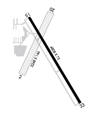
| Rwy | Rwy | |||||||
| 3248x146 | 3248' | 3248x146 | 3248' | |||||
| 4808x75 | 4668' | 4808x75 | 4808' | |||||
| Runway ID | Single Wheel | Double Wheel | Double Tandem Wheel | Dual Double Wheel |
| 02/20 | N/A | N/A | N/A | N/A |
| 15/33 | 30,000 | N/A | N/A | N/A |
| These numbers are Advisory and are not limits. The Airport Manager should have more accurate Weight Limits | ||||
 Airport Diagram might not be current. | |
| Facility Name: | BOONE MUNI |
| City Name: | BOONE |
| County: | BOONE |
| State abbrev: | IA |
| State Name: | IOWA |
| Ownership: | PUBLICLY OWNED |
| Use: | OPEN TO THE PUBLIC |
| Owner's Name: | CITY OF BOONE; JOE PUNDZAK, CHAIRMAN ARPT CMSN. |
| Address: | 923 8TH ST |
| BOONE, IA 50036 | |
| Owner's Phone: | 515-432-4211 |
| Manager's Name: | DALE E. FARNHAM |
| Address: | 424 CPL ROGER SNEDDEN DR |
| BOONE, IA 50036-7520 | |
| Phone: | 515-432-1018 |
| FAA Region: | CENTRAL |
| FAA Field Office: | NONE |
| Date | Sunrise | Sunset |
|---|---|---|
| 09/24/21 Friday | 7:05 | 19:10 |
| 09/25/21 Saturday | 7:06 | 19:08 |
| 09/26/21 Sunday | 7:07 | 19:06 |
| 09/27/21 Monday | 7:08 | 19:04 |
| 09/28/21 Tuesday | 7:09 | 19:03 |
| 09/29/21 Wednesday | 7:10 | 19:01 |
| 09/30/21 Thursday | 7:11 | 18:59 |
| 10/01/21 Friday | 7:12 | 18:57 |
| 10/02/21 Saturday | 7:13 | 18:56 |
| 10/03/21 Sunday | 7:14 | 18:54 |
| 10/04/21 Monday | 7:15 | 18:52 |
| 10/05/21 Tuesday | 7:16 | 18:50 |
| 10/06/21 Wednesday | 7:18 | 18:49 |
| 10/07/21 Thursday | 7:19 | 18:47 |
| Airport Attendance Schedule | 7 Days A Week 0800-1700; OT CALL (515) 291-5094 OR (515) 460-3892. |
| Airport Status | OPERATIONAL (This Status can change at any time - please check NOTAMS) |
| Airport Lighting Schedule | ACTVT MIRL RY 15/33; PAPI RWY 15 & 33; REIL RY 15/33 - CTAF. |
| Airport Storage Available | Tie Downs, Hanger |
| Extra Services Available | Flight Instruction, Aircraft Rental |
| Wind Indicator | YES - (lighted) |
| Control Tower | NO |
| CTAF Frequency | 123.000 |
| Unicom Frequency | 123.000 |
| Rotating Beacon Color | CLEAR-GREEN (Light Land Airport) |
| Segmented Circle | NO |
| Landing Fee | NO |
| Airport Inspected | STATE - performed by STATE AERONAUTICAL PERSONNEL |
| Inspection Date | 09/10/2018 |
| Type of Fuel Available | Grade 100LL, JET A (freeze point -40C)MOGAS; -10FOR FUEL ON HOLS OR AFTER HRS CALL (515) 291-5094. |
| Airframe Repair Service | MINOR |
| Power Plant Repair Service | MINOR |
| Latitude | N4203.0 |
| Longitude | W09350.9 (ESTIMATED) |
| Arpt Elevation | 1160ft (SURVEYED) |
| Magnetic Variation | 03E |
| 2 miles SE | of BOONE |
| Traffic Pattern Altitude | |
| Sectional Chart | OMAHA |
| Operations (Reported) | Yearly | Avg. Daily |
|---|---|---|
| General Aviation Transient | 5090 | 14 |
| General Aviation Local | 6540 | 18 |
| Air Taxi | 0 | 0 |
| Commerical | 0 | 0 |
| Commuter | 0 | 0 |
| Military | 9070 | 25 |
| Aircraft based on Field | |
|---|---|
| General Aviation Singles | 34 |
| General Aviation Multi | 2 |
| Jet Aircraft | 0 |
| General Aviation Helicopters | 0 |
| Military Aircraft | 6 |
| Gliders | 0 |
| Ultralights | 0 |
| FSS on field | NO |
| FSS tie-in | FORT DODGE |
| FSS Phone | 1-800-WX-BRIEF |
| Who issues Notams | BNW |
| Notam D service at airport | YES |
| ARTCC Name | MINNEAPOLIS |
| Airport Certification | |
| Aircraft Rescue & Firefighting Index | None |
| Airport of Entry | No |
| Custom Landing Rights | No |
| Joint Civil/Military | No |
| Military Landing rights | YES |
| NATIONAL PLAN OF INTEGRATED AIRPORT SYSTEMS (NPIAS) |
| GRANT AGREEMENTS UNDER FAAP/ADAP/AIP |
| ASSURANCES PURSUANT TO TITLE VI, CIVIL RIGHTS ACT OF 1964 |
| ANG OPNS AV946-2388 (515) 432-6351. CTC ANG OPS 36.7/142.6/143.25/231.55. |
| PAJA ON & INVOF ARPT. |
| ARPT UNATNDD HOLS AND WHEN THE CEILING IS LESS THAN 400 FT OR THE VISIBILITY IS LESS THAN ONE MILE. |
| FOR CD CTC DES MOINES ATCT AT 515-974- 8016. |
Airport Communications & Frequencies:
| ||||||||||||||
| Runway: 02 | Runway: 20 | ||
| Mag heading: | 22° | Mag heading: | 202° |
| Rwy Slope: | -.74% Down | Rwy Slope: | .74% Up |
| Approach: | Approach: | ||
| Pattern: | Right Traffic | Pattern: | Left Traffic |
| Markings: | Markings: | ||
| Marking Condition: | 02/20 MKD WITH YELLOW CONES. | Marking Condition: | |
| Arresting Dev: | Arresting Dev: | ||
| Lat & Long: | N4202.8 W09351.1 | Lat. & Long.: | N4203.3 W09350.8 |
| Elev: | 1160.3 ft. MSL | Elev: | 1136.2 ft. MSL |
| TCH: | TCH: | ||
| Visual Glide Path: | Visual Glide Path: | ||
| Displaced Threshold: | No | Displaced Threshold: | No |
| Touchdown Zone: | YES | Touchdown Zone: | YES |
| Touchdown Elev.: | 1160.3 feet | Touchdown Elev.: | 1156.3 feet |
| Visual Glide Slope: | Visual Glide Slope: | ||
| RVR Equipment: | RVR Equipment: | ||
| RVV Equipment: | NO | RVV Equipment: | NO |
| Approach Lights: | Approach Lights: | ||
| REIL: | NO | REIL: | NO |
| Centerline Lights: | NO | Centerline Lights: | NO |
| Touchdown lights: | NO | Touchdown lights: | NO |
| Runway Category: | Runway with a Visual Approach | Runway Category: | Runway with a Visual Approach |
| Declared Distances: | Declared Distances: | ||
| Obstructions: | Obstructions: | POLE | |
| Marked: | Marked: | NOT Marked/Lighted | |
| Clearance slope: | 50:1 | Clearance slope: | 23:1 |
| Obstruction height: | Obstruction height: | 55 feet AGL | |
| Dist. from runway: | Dist. from runway: | 1300 feet | |
| Centerline offset: | Centerline offset: | ||
| Comments: | Comments: |
| Runway: 15 | Runway: 33 | ||
| Mag heading: | 146° | Mag heading: | 326° |
| Rwy Slope: | .02% Up | Rwy Slope: | -.02% Down |
| Approach: | Approach: | ||
| Pattern: | Left Traffic | Pattern: | Right Traffic |
| Markings: | NONPRECISION INSTRUMENT | Markings: | NONPRECISION INSTRUMENT |
| Marking Condition: | GOOD | Marking Condition: | GOOD |
| Arresting Dev: | Arresting Dev: | ||
| Lat & Long: | N4203.3 W09351.1 | Lat. & Long.: | N4202.6 W09350.5 |
| Elev: | 1137.7 ft. MSL | Elev: | 1138.5 ft. MSL |
| TCH: | 25 ft. AGL | TCH: | 25 ft. AGL |
| Visual Glide Path: | 3.00 degrees | Visual Glide Path: | 3.00 degrees |
| Displaced Threshold: | 140 feet | Displaced Threshold: | No |
| Touchdown Zone: | YES | Touchdown Zone: | YES |
| Touchdown Elev.: | 1139.0 feet | Touchdown Elev.: | 1138.5 feet |
| Visual Glide Slope: | 2-Light PAPI on LEFT side of Runway | Visual Glide Slope: | 2-Light PAPI on LEFT side of Runway |
| RVR Equipment: | RVR Equipment: | ||
| RVV Equipment: | NO | RVV Equipment: | NO |
| Approach Lights: | Approach Lights: | ||
| REIL: | YES | REIL: | YES |
| Centerline Lights: | NO | Centerline Lights: | NO |
| Touchdown lights: | NO | Touchdown lights: | NO |
| Runway Category: | Runway with a Non-precision Approach having visibility minimums greater than 3/4 mile | Runway Category: | Runway with a Non-precision Approach having visibility minimums greater than 3/4 mile |
| Declared Distances: | TORA:4807' TODA:4807' ASDA:4807' LDA:4667' | Declared Distances: | TORA:4667' TODA:4807' ASDA:4807' LDA:4807' |
| Obstructions: | TREE | Obstructions: | |
| Marked: | NOT Marked/Lighted | Marked: | |
| Clearance slope: | 20:1; 28:1 TO DISPLACED THRESHOLD | Clearance slope: | 50:1 |
| Obstruction height: | 41 feet AGL | Obstruction height: | |
| Dist. from runway: | 1026 feet | Dist. from runway: | |
| Centerline offset: | 164 left of centerline | Centerline offset: | |
| Comments: | Comments: |
Thanks for using FltPlan.com
all rights reserved © 1999-2021 by Flight Plan LLC
