| BURNS MUNI BURNS OR |
| |
| Lat: N 4335.5 Long: W 11857.3 Elev: 4148 Var: -18 Longest Runway: 5101 | ||
| AWOS: 135.57 CTAF: 122.8 | ||
| ||||||||||||||||||||||||||||||||||||||||||||||||||||||||||||||||||||
| ||||||||||||||||||||||||||||||||||||||||||||||||||||||||||||||||||||
| ||||||||||||||||||||||||||||||||||||||||||||||||||||||||||||||||||||
| Rwy | Rwy | |||||||
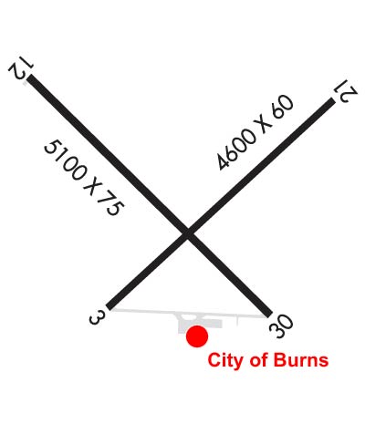
| 4600x60 | 4000' | 4600x60 | 4600' | |||||
| 5101x75 | 5101' | 5101x75 | 5101' | |||||
| Runway ID | Single Wheel | Double Wheel | Double Tandem Wheel | Dual Double Wheel |
| 03/21 | 30,000 | N/A | N/A | N/A |
| 12/30 | 30,000 | 50,000 | 90,000 | N/A |
| These numbers are Advisory and are not limits. The Airport Manager should have more accurate Weight Limits | ||||
 Airport Diagram might not be current. | |
| Facility Name: | BURNS MUNI |
| City Name: | BURNS |
| County: | HARNEY |
| State abbrev: | OR |
| State Name: | OREGON |
| Ownership: | PUBLICLY OWNED |
| Use: | OPEN TO THE PUBLIC |
| Owner's Name: | CITY OF BURNS |
| Address: | 242 S. BROADWAY |
| BURNS, OR 97720 | |
| Owner's Phone: | 541-573-5255 |
| Manager's Name: | SCOTT WILLIAMSON |
| Address: | 70346 TERMINAL WAY |
| BURNS, OR 97720 | |
| Phone: | 541-480-3854 |
| FAA Region: | NORTHWEST MOUNTAIN |
| FAA Field Office: | SEA |

| Date | Sunrise | Sunset |
|---|---|---|
| 06/08/26 Monday | 5:15 | 20:35 |
| 06/09/26 Tuesday | 5:14 | 20:36 |
| 06/10/26 Wednesday | 5:14 | 20:36 |
| 06/11/26 Thursday | 5:14 | 20:37 |
| 06/12/26 Friday | 5:14 | 20:37 |
| 06/13/26 Saturday | 5:14 | 20:38 |
| 06/14/26 Sunday | 5:14 | 20:38 |
| 06/15/26 Monday | 5:14 | 20:39 |
| 06/16/26 Tuesday | 5:14 | 20:39 |
| 06/17/26 Wednesday | 5:14 | 20:40 |
| 06/18/26 Thursday | 5:14 | 20:40 |
| 06/19/26 Friday | 5:14 | 20:40 |
| 06/20/26 Saturday | 5:14 | 20:40 |
| 06/21/26 Sunday | 5:14 | 20:41 |
| Airport Attendance Schedule | UNATTENDED |
| Airport Status | OPERATIONAL (This Status can change at any time - please check NOTAMS) |
| Airport Lighting Schedule | ACTVT MIRL RYS 03/21 & 12/30, PAPI RYS 03 & 21, VASI RYS 12 & 30, & REILS RYS 03, 21, 12, & 30 - CTAF. |
| Airport Storage Available | Tie Downs, Hanger |
| Extra Services Available | NONE |
| Wind Indicator | YES - (lighted) |
| Control Tower | NO |
| CTAF Frequency | 122.800 |
| Unicom Frequency | 122.800 |
| Rotating Beacon Color | WG |
| Segmented Circle | YES |
| Landing Fee | NO |
| Airport Inspected | STATE - performed by STATE AERONAUTICAL PERSONNEL |
| Inspection Date | 09/20/2024 |
| Type of Fuel Available | Grade 100LL, JET A (freeze point -40C) |
| Airframe Repair Service | NONE |
| Power Plant Repair Service | NONE |
| Latitude | N4335.5 |
| Longitude | W11857.3 (ESTIMATED) |
| Arpt Elevation | 4148ft (SURVEYED) |
| Magnetic Variation | 18E |
| 5 miles E | of BURNS |
| Traffic Pattern Altitude | |
| Sectional Chart | KLAMATH FALLS |
| Operations (Reported) | Yearly | Avg. Daily |
|---|---|---|
| General Aviation Transient | 0 | 0 |
| General Aviation Local | 0 | 0 |
| Air Taxi | 0 | 0 |
| Commerical | 0 | 0 |
| Commuter | 0 | 0 |
| Military | 0 | 0 |
| Aircraft based on Field | |
|---|---|
| General Aviation Singles | 0 |
| General Aviation Multi | 0 |
| Jet Aircraft | 0 |
| General Aviation Helicopters | 0 |
| Military Aircraft | 0 |
| Gliders | 0 |
| Ultralights | 0 |
| FSS on field | NO |
| FSS tie-in | MC MINNVILLE |
| FSS Phone | 1-800-WX-BRIEF |
| Who issues Notams | BNO |
| Notam D service at airport | YES |
| ARTCC Name | SALT LAKE CITY |
| Airport Certification | |
| Aircraft Rescue & Firefighting Index | None |
| Airport of Entry | No |
| Custom Landing Rights | No |
| Joint Civil/Military | No |
| Military Landing rights | YES |
| NATIONAL PLAN OF INTEGRATED AIRPORT SYSTEMS (NPIAS) |
| GRANT AGREEMENTS UNDER FAAP/ADAP/AIP |
| ASSURANCES PURSUANT TO TITLE VI, CIVIL RIGHTS ACT OF 1964 |
| AGREEMENT UNDER DLAND OR DCLA HAS EXPIRED. |
| FLOCKS OF LARGE BIRDS INVOF ARPT FEB - MAY & SEP - OCT. |
| FOR CD IF UNA TO CTC ON FSS FREQ, CTC SALT LAKE ARTCC AT 801-320-2568. |
Airport Communications & Frequencies:
| |||||||||
| Runway: 03 | Runway: 21 | ||
| Mag heading: | 30° | Mag heading: | 210° |
| Rwy Slope: | -.05% Down | Rwy Slope: | .05% Up |
| Approach: | Approach: | ||
| Pattern: | Left Traffic | Pattern: | Left Traffic |
| Markings: | BASIC | Markings: | BASIC |
| Marking Condition: | GOOD | Marking Condition: | GOOD |
| Arresting Dev: | Arresting Dev: | ||
| Lat & Long: | N4335.2 W11857.6 | Lat. & Long.: | N4335.8 W11856.8 |
| Elev: | 4146.2 ft. MSL | Elev: | 4143.7 ft. MSL |
| TCH: | 36 ft. AGL | TCH: | 37 ft. AGL |
| Visual Glide Path: | 3.00 degrees | Visual Glide Path: | 3.00 degrees |
| Displaced Threshold: | 600 feet | Displaced Threshold: | No |
| Touchdown Zone: | YES | Touchdown Zone: | YES |
| Touchdown Elev.: | 4148.2 feet | Touchdown Elev.: | 4148.0 feet |
| Visual Glide Slope: | 2-Light PAPI on LEFT side of Runway | Visual Glide Slope: | 2-Light PAPI on LEFT side of Runway |
| RVR Equipment: | RVR Equipment: | ||
| RVV Equipment: | NO | RVV Equipment: | NO |
| Approach Lights: | Approach Lights: | ||
| REIL: | YES | REIL: | YES |
| Centerline Lights: | NO | Centerline Lights: | NO |
| Touchdown lights: | NO | Touchdown lights: | NO |
| Runway Category: | Runway with a Visual Approach | Runway Category: | Runway with a Visual Approach |
| Declared Distances: | Declared Distances: | ||
| Obstructions: | PLINE | Obstructions: | |
| Marked: | LIGHTED | Marked: | |
| Clearance slope: | 21:1; RWY 03 APRCH RATIO 50:1 TO DSPLCD THR. | Clearance slope: | 50:1 |
| Obstruction height: | 32 feet AGL | Obstruction height: | |
| Dist. from runway: | 900 feet | Dist. from runway: | |
| Centerline offset: | Centerline offset: | ||
| Comments: | Comments: |
| Runway: 12 | Runway: 30 | ||
| Mag heading: | 117° | Mag heading: | 297° |
| Rwy Slope: | -.07% Down | Rwy Slope: | .07% Up |
| Approach: | Approach: | ||
| Pattern: | Left Traffic | Pattern: | Left Traffic |
| Markings: | BASIC | Markings: | NONPRECISION INSTRUMENT |
| Marking Condition: | GOOD | Marking Condition: | GOOD |
| Arresting Dev: | Arresting Dev: | ||
| Lat & Long: | N4335.8 W11857.9 | Lat. & Long.: | N4335.2 W11857.0 |
| Elev: | 4147.7 ft. MSL | Elev: | 4144.3 ft. MSL |
| TCH: | 43 ft. AGL | TCH: | 47 ft. AGL |
| Visual Glide Path: | 3.00 degrees | Visual Glide Path: | 3.00 degrees |
| Displaced Threshold: | No | Displaced Threshold: | No |
| Touchdown Zone: | YES | Touchdown Zone: | YES |
| Touchdown Elev.: | 4147.7 feet | Touchdown Elev.: | 4148.1 feet |
| Visual Glide Slope: | 2-Box VASI on LEFT side of Runway | Visual Glide Slope: | 2-Box VASI on LEFT side of Runway |
| RVR Equipment: | RVR Equipment: | ||
| RVV Equipment: | NO | RVV Equipment: | NO |
| Approach Lights: | Approach Lights: | ||
| REIL: | YES | REIL: | YES |
| Centerline Lights: | NO | Centerline Lights: | NO |
| Touchdown lights: | NO | Touchdown lights: | NO |
| Runway Category: | Runway with a Visual Approach | Runway Category: | Runway with a Non-precision Approach having visibility minimums greater than 3/4 mile |
| Declared Distances: | Declared Distances: | ||
| Obstructions: | Obstructions: | ROAD | |
| Marked: | Marked: | NOT Marked/Lighted | |
| Clearance slope: | 50:1 | Clearance slope: | 50:1 |
| Obstruction height: | Obstruction height: | 14 feet AGL | |
| Dist. from runway: | Dist. from runway: | 900 feet | |
| Centerline offset: | Centerline offset: | 205 feet left of centerline | |
| Comments: | Comments: |
Thanks for using FltPlan.com
all rights reserved © 1999-2026 by Flight Plan LLC