| CENTRAL IL REGL ARPT AT BLOOMI BLOOMINGTON/NORMAL IL |
| |
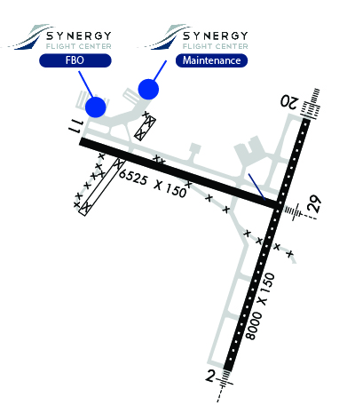
| Lat: N 4028.6 Long: W 08855.0 Elev: 871 Var: +03 Longest Runway: 8000 | ||
| Dept. ATIS: 135.35 Arr. ATIS: 135.35 AWOS: 135.35 Ground: 121.65 Tower: 124.6 | ||
| ||||||||||||||||||||||||||||||||||||||||||||||||||||||||||||||||||||
| ||||||||||||||||||||||||||||||||||||||||||||||||||||||||||||||||||||
| ||||||||||||||||||||||||||||||||||||||||||||||||||||||||||||||||||||
| Rwy | Rwy | |||||||
| 8000x150 | 8000' | 111.55 - 020° | 8000x150 | 8000' | 111.55 - 200° | |||
| 6525x150 | 6525' | 6525x150 | 6525' | 110.95 - 290° | ||||
| Runway ID | Single Wheel | Double Wheel | Double Tandem Wheel | Dual Double Wheel |
| 02/20 | 75,000 | 150,000 | 300,000 | N/A |
| 11/29 | 75,000 | 150,000 | 300,000 | N/A |
| These numbers are Advisory and are not limits. The Airport Manager should have more accurate Weight Limits | ||||
 Airport Diagram might not be current. | |
| Facility Name: | CENTRAL IL RGNL/BLOOMINGTON-NORMAL |
| City Name: | BLOOMINGTON/NORMAL |
| County: | MC LEAN |
| State abbrev: | IL |
| State Name: | ILLINOIS |
| Ownership: | PUBLICLY OWNED |
| Use: | OPEN TO THE PUBLIC |
| Owner's Name: | BLOOMINGTON NORMAL ARPT AUTH |
| Address: | 3201 CIRA DRIVE |
| BLOOMINGTON, IL 61704 | |
| Owner's Phone: | 309-663-7383 |
| Manager's Name: | CARL G. OLSON |
| Address: | 3201 CIRA DRIVE |
| BLOOMINGTON, IL 61704 | |
| Phone: | 309-663-7383 |
| FAA Region: | GREAT LAKES |
| FAA Field Office: | CHI |

| Date | Sunrise | Sunset |
|---|---|---|
| 09/24/21 Friday | 6:45 | 18:50 |
| 09/25/21 Saturday | 6:46 | 18:48 |
| 09/26/21 Sunday | 6:47 | 18:46 |
| 09/27/21 Monday | 6:48 | 18:45 |
| 09/28/21 Tuesday | 6:49 | 18:43 |
| 09/29/21 Wednesday | 6:50 | 18:41 |
| 09/30/21 Thursday | 6:51 | 18:40 |
| 10/01/21 Friday | 6:52 | 18:38 |
| 10/02/21 Saturday | 6:53 | 18:37 |
| 10/03/21 Sunday | 6:54 | 18:35 |
| 10/04/21 Monday | 6:55 | 18:33 |
| 10/05/21 Tuesday | 6:56 | 18:32 |
| 10/06/21 Wednesday | 6:57 | 18:30 |
| 10/07/21 Thursday | 6:58 | 18:28 |
| Airport Attendance Schedule | 7 Days A Week 0400L-2400L |
| Airport Status | OPERATIONAL (This Status can change at any time - please check NOTAMS) |
| Airport Lighting Schedule | ACTIVATE HIRL RWY 11-29, HIRL RWY 2-20, CL 2-20, TDZL RWY 20, MALSR RWYS 2 & 29, PAPI RWY 2 - CTAF. ALSF ONLY AVBL WHEN TWR OPEN. |
| Airport Storage Available | Tie Downs, Hanger |
| Extra Services Available | Air Freight, Air Ambulance, Avionics, Charter, Flight Instruction, Aircraft Rental, Aircraft Sales |
| Wind Indicator | YES - (lighted) |
| Control Tower | YES |
| CTAF Frequency | 124.600 |
| Unicom Frequency | 122.950 |
| Rotating Beacon Color | CLEAR-GREEN (Light Land Airport) |
| Segmented Circle | NO |
| Landing Fee | NO |
| Airport Inspected | FEDERAL - performed by FAA AIRPORTS FIELD PERSONNEL |
| Inspection Date | 12/01/2017 |
| Type of Fuel Available | Grade 100LL, JET A (freeze point -40C) |
| Airframe Repair Service | MAJOR |
| Power Plant Repair Service | MAJOR |
| Latitude | N4028.6 |
| Longitude | W08855.0 (ESTIMATED) |
| Arpt Elevation | 871ft (SURVEYED) |
| Magnetic Variation | 03W |
| 3 miles E | of BLOOMINGTON/NORMAL |
| Traffic Pattern Altitude | |
| Sectional Chart | CHICAGO |
| Operations (Reported) | Yearly | Avg. Daily |
|---|---|---|
| General Aviation Transient | 9655 | 26 |
| General Aviation Local | 4665 | 13 |
| Air Taxi | 1276 | 3 |
| Commerical | 3525 | 10 |
| Commuter | 0 | 0 |
| Military | 901 | 2 |
| Aircraft based on Field | |
|---|---|
| General Aviation Singles | 58 |
| General Aviation Multi | 4 |
| Jet Aircraft | 11 |
| General Aviation Helicopters | 1 |
| Military Aircraft | 0 |
| Gliders | 0 |
| Ultralights | 0 |
| FSS on field | NO |
| FSS tie-in | KANKAKEE |
| FSS Phone | 1-800-WX-BRIEF |
| Who issues Notams | BMI |
| Notam D service at airport | YES |
| ARTCC Name | CHICAGO |
| Airport Certification | AIRPORT RECEIVING SCHEDULED AIR CARRIER SERVICE FROM CARRIERS CERTIFICATED BY THE CIVIL AERONAUTICS BOARD; 48 HR PPR FOR UNSKED ACR OPNS WITH MORE THAN 30 PSGR SEATS; CALL AMGR 309-663-7383. |
| Aircraft Rescue & Firefighting Index | AIRPORT HAS A CERTIFICATE UNDER CFR PART 139 |
| Airport of Entry | No |
| Custom Landing Rights | No |
| Joint Civil/Military | No |
| Military Landing rights | YES |
| NATIONAL PLAN OF INTEGRATED AIRPORT SYSTEMS (NPIAS) |
| GRANT AGREEMENTS UNDER FAAP/ADAP/AIP |
| ASSURANCES PURSUANT TO TITLE VI, CIVIL RIGHTS ACT OF 1964 |
| BIRDS ON AND INVOF ARPT. |
| SNOW REMOVAL OPS IN PROGRESS WINTER MONTHS; EQUIPMENT OPERATORS WILL BE MONITORING CTAF WHEN TWR CLSD. |
| ACFT LDG/DEPARTING BLOOMINGTON SHOULD ANNOUNCE INTENTIONS ON CTAF WHEN ATCT CLSD. |
| ARPT OPNS AVBL 24 HRS AT 309-834-7396. |
| RWY 11/2 9 SE END OF RY 29 565 FT CONC, REMAINING 5960 FT ASPH. |
Airport Communications & Frequencies:
| ||||||||||||||||||||||||
| Runway: 02 | Runway: 20 | ||
| Mag heading: | 21° | Mag heading: | 201° |
| Rwy Slope: | .08% Up | Rwy Slope: | -.08% Down |
| Approach: | ILS/DME | Approach: | ILS/DME |
| Pattern: | Left Traffic | Pattern: | Left Traffic |
| Markings: | PRECISION INSTRUMENT | Markings: | PRECISION INSTRUMENT |
| Marking Condition: | FAIR | Marking Condition: | FAIR |
| Arresting Dev: | Arresting Dev: | ||
| Lat & Long: | N4027.8 W08855.0 | Lat. & Long.: | N4029.1 W08854.4 |
| Elev: | 856.4 ft. MSL | Elev: | 862.5 ft. MSL |
| TCH: | 75 ft. AGL | TCH: | |
| Visual Glide Path: | 3.00 degrees | Visual Glide Path: | |
| Displaced Threshold: | No | Displaced Threshold: | No |
| Touchdown Zone: | YES | Touchdown Zone: | YES |
| Touchdown Elev.: | 866.7 feet | Touchdown Elev.: | 870.9 feet |
| Visual Glide Slope: | 4-Light PAPI on RIGHT side of Runway | Visual Glide Slope: | |
| RVR Equipment: | TOUCHDOWN-MIDFIELD-ROLLOUT | RVR Equipment: | TOUCHDOWN-MIDFIELD-ROLLOUT |
| RVV Equipment: | NO | RVV Equipment: | NO |
| Approach Lights: | MALSR - 1,400 foot medium intensity approach lighting system with runway alignment indicator lights | Approach Lights: | ALSF2 - standard 2,400 foot high intensity approach lighting system with sequenced flashers, Category II or III; ALSF2 OPR AS SSALR WHEN TWR CLSD. |
| REIL: | NO | REIL: | NO |
| Centerline Lights: | YES | Centerline Lights: | YES |
| Touchdown lights: | NO | Touchdown lights: | YES |
| Runway Category: | Precision Instrument Runway | Runway Category: | Precision Instrument Runway |
| Declared Distances: | TORA:8000' TODA:8000' ASDA:8000' LDA:8000' | Declared Distances: | TORA:8000' TODA:8000' ASDA:8000' LDA:8000' |
| Obstructions: | Obstructions: | PLINE | |
| Marked: | Marked: | NOT Marked/Lighted | |
| Clearance slope: | 50:1 | Clearance slope: | 45:1 |
| Obstruction height: | Obstruction height: | 40 feet AGL | |
| Dist. from runway: | Dist. from runway: | 2007 feet | |
| Centerline offset: | Centerline offset: | 770 feet left of centerline | |
| Comments: | Comments: |
| Runway: 11 | Runway: 29 | ||
| Mag heading: | 110° | Mag heading: | 290° |
| Rwy Slope: | .00% Down | Rwy Slope: | .00% Up |
| Approach: | Approach: | ILS/DME | |
| Pattern: | Left Traffic | Pattern: | Left Traffic |
| Markings: | PRECISION INSTRUMENT | Markings: | PRECISION INSTRUMENT |
| Marking Condition: | GOOD | Marking Condition: | GOOD |
| Arresting Dev: | Arresting Dev: | ||
| Lat & Long: | N4029.0 W08855.9 | Lat. & Long.: | N4028.7 W08854.6 |
| Elev: | 871.4 ft. MSL | Elev: | 871.1 ft. MSL |
| TCH: | 43 ft. AGL | TCH: | |
| Visual Glide Path: | 3.00 degrees | Visual Glide Path: | |
| Displaced Threshold: | No | Displaced Threshold: | No |
| Touchdown Zone: | YES | Touchdown Zone: | YES |
| Touchdown Elev.: | 871.4 feet | Touchdown Elev.: | 871.4 feet |
| Visual Glide Slope: | 4-BOX VASI ON RIGHT SIDE OF RUNWAY | Visual Glide Slope: | |
| RVR Equipment: | ROLLOUT | RVR Equipment: | TOUCHDOWN |
| RVV Equipment: | NO | RVV Equipment: | NO |
| Approach Lights: | Approach Lights: | MALSR - 1,400 foot medium intensity approach lighting system with runway alignment indicator lights | |
| REIL: | NO | REIL: | NO |
| Centerline Lights: | NO | Centerline Lights: | NO |
| Touchdown lights: | NO | Touchdown lights: | NO |
| Runway Category: | D | Runway Category: | Precision Instrument Runway |
| Declared Distances: | TORA:6525' TODA:6525' ASDA:6525' LDA:6525' | Declared Distances: | TORA:6525' TODA:6525' ASDA:6525' LDA:6525' |
Thanks for using FltPlan.com
all rights reserved © 1999-2021 by Flight Plan LLC