
| BLUE CANYON - NYACK EMIGRANT GAP CA |
| |
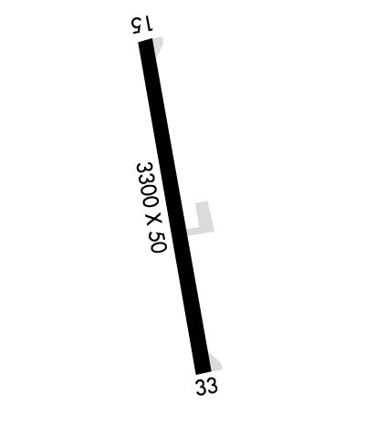
| Lat: N 3916.5 Long: W 12042.6 Elev: 5284 Var: -16 Longest Runway: 3300 | ||
| AWOS: 120.07 CTAF: 122.9 | ||
| ||||||||||||||||||||||||||||||||
| ||||||||||||||||||||||||||||||||
| ||||||||||||||||||||||||||||||||
| Rwy | Rwy | |||||||
| 3300x50 | 3300' | 3300x50 | 3300' | |||||
| Runway ID | Single Wheel | Double Wheel | Double Tandem Wheel | Dual Double Wheel |
| 15/33 | 12,000 | N/A | N/A | N/A |
| These numbers are Advisory and are not limits. The Airport Manager should have more accurate Weight Limits | ||||
| FltPlan does not have IFR approach charts available for KBLU. |
 Airport Diagram might not be current. | |
| Facility Name: | BLUE CANYON - NYACK |
| City Name: | EMIGRANT GAP |
| County: | PLACER |
| State abbrev: | CA |
| State Name: | CALIFORNIA |
| Ownership: | PUBLICLY OWNED |
| Use: | OPEN TO THE PUBLIC |
| Owner's Name: | COUNTY OF PLACER |
| Address: | 3091 COUNTY CTR DR. |
| AUBURN, CA 95603 | |
| Owner's Phone: | 530-745-7500 |
| Manager's Name: | JOHN WEBER |
| Address: | 3091 COUNTY CTR DR. SUITE 220 |
| AUBURN, CA 95603 | |
| Phone: | 530-745-7564; LOCATED AT DEPT OF PUBLIC WORKS OFFICE, AUBURN, CA. |
| FAA Region: | WESTERN-PACIFIC |
| FAA Field Office: | SFO |

| Date | Sunrise | Sunset |
|---|---|---|
| 09/24/21 Friday | 6:52 | 18:57 |
| 09/25/21 Saturday | 6:53 | 18:55 |
| 09/26/21 Sunday | 6:54 | 18:54 |
| 09/27/21 Monday | 6:55 | 18:52 |
| 09/28/21 Tuesday | 6:56 | 18:50 |
| 09/29/21 Wednesday | 6:57 | 18:49 |
| 09/30/21 Thursday | 6:58 | 18:47 |
| 10/01/21 Friday | 6:59 | 18:46 |
| 10/02/21 Saturday | 7:00 | 18:44 |
| 10/03/21 Sunday | 7:01 | 18:42 |
| 10/04/21 Monday | 7:02 | 18:41 |
| 10/05/21 Tuesday | 7:03 | 18:39 |
| 10/06/21 Wednesday | 7:04 | 18:38 |
| 10/07/21 Thursday | 7:05 | 18:36 |
| Airport Attendance Schedule | UNATTENDED; ARPT CLSD WINTERS DUE TO SNOW. |
| Airport Status | OPERATIONAL (This Status can change at any time - please check NOTAMS) |
| Airport Lighting Schedule | ACTVT MIRL RWY 15/33 - CTAF.; ACTVT ROTG BCN - CTAF. |
| Airport Storage Available | Tie Downs |
| Extra Services Available | NONE |
| Wind Indicator | YES - (lighted) |
| Control Tower | NO |
| CTAF Frequency | 122.900 |
| Unicom Frequency | |
| Rotating Beacon Color | CLEAR-GREEN (Light Land Airport); ROTG BCN OTS INDEFLY . |
| Segmented Circle | NO |
| Landing Fee | NO |
| Airport Inspected | STATE - performed by STATE AERONAUTICAL PERSONNEL |
| Inspection Date | 07/09/2019 |
| Type of Fuel Available | None |
| Airframe Repair Service | NONE |
| Power Plant Repair Service | NONE |
| Latitude | N3916.5 |
| Longitude | W12042.6 (ESTIMATED) |
| Arpt Elevation | 5283ft (ESTIMATED) |
| Magnetic Variation | 16E |
| 1 miles S | of EMIGRANT GAP |
| Traffic Pattern Altitude | |
| Sectional Chart | SAN FRANCISCO |
| Operations (Reported) | Yearly | Avg. Daily |
|---|---|---|
| General Aviation Transient | 1100 | 3 |
| General Aviation Local | 0 | 0 |
| Air Taxi | 0 | 0 |
| Commerical | 0 | 0 |
| Commuter | 0 | 0 |
| Military | 100 | 0 |
| Aircraft based on Field | |
|---|---|
| General Aviation Singles | 0 |
| General Aviation Multi | 0 |
| Jet Aircraft | 0 |
| General Aviation Helicopters | 0 |
| Military Aircraft | 0 |
| Gliders | 0 |
| Ultralights | 0 |
| FSS on field | NO |
| FSS tie-in | RANCHO MURIETA |
| FSS Phone | 1-800-WX-BRIEF |
| Who issues Notams | BLU |
| Notam D service at airport | YES |
| ARTCC Name | OAKLAND |
| Airport Certification | |
| Aircraft Rescue & Firefighting Index | None |
| Airport of Entry | No |
| Custom Landing Rights | No |
| Joint Civil/Military | No |
| Military Landing rights | No |
| THIS AIRPORT HAS BEEN SURVEYED BY THE NATIONAL GEODETIC SURVEY. |
| ARPT CLSD SS-SR. |
| DO NOT ATTEMPT TO LAND WITH SNOW ON THE RUNWAY. NO SNOW REMOVAL SERVICES ARE PROVIDED. |
| FOR CD CTC OAKLAND ARTCC AT 510-745-3380. |
| RWY 15/3 3 MIRL RY 15/33 OTS INDEFLY . |
| Runway: 15 | Runway: 33 | ||
| Mag heading: | N/A | Mag heading: | N/A |
| Rwy Slope: | -1.14% Down | Rwy Slope: | 1.14% Up |
| Approach: | Approach: | ||
| Pattern: | Left Traffic | Pattern: | Left Traffic |
| Markings: | BASIC | Markings: | BASIC |
| Marking Condition: | GOOD | Marking Condition: | GOOD |
| Arresting Dev: | Arresting Dev: | ||
| Lat & Long: | N3916.8 W12042.7 | Lat. & Long.: | N3916.2 W12042.5 |
| Elev: | 5283.5 ft. MSL | Elev: | 5245.9 ft. MSL |
| TCH: | TCH: | ||
| Visual Glide Path: | Visual Glide Path: | ||
| Displaced Threshold: | No | Displaced Threshold: | No |
| Touchdown Zone: | NO | Touchdown Zone: | NO |
| Touchdown Elev.: | Touchdown Elev.: | ||
| Visual Glide Slope: | Visual Glide Slope: | ||
| RVR Equipment: | RVR Equipment: | ||
| RVV Equipment: | NO | RVV Equipment: | NO |
| Approach Lights: | Approach Lights: | ||
| REIL: | NO | REIL: | NO |
| Centerline Lights: | NO | Centerline Lights: | NO |
| Touchdown lights: | NO | Touchdown lights: | NO |
| Runway Category: | Runway with a Visual Approach | Runway Category: | Runway with a Visual Approach |
| Declared Distances: | Declared Distances: | ||
| Obstructions: | TREE | Obstructions: | TREE |
| Marked: | NOT Marked/Lighted | Marked: | NOT Marked/Lighted |
| Clearance slope: | 27:1 | Clearance slope: | 13:1 |
| Obstruction height: | 20 feet AGL | Obstruction height: | 15 feet AGL |
| Dist. from runway: | 750 feet | Dist. from runway: | 400 feet |
| Centerline offset: | 110 left of centerline | Centerline offset: | |
| Comments: | RWY 15 +4 FT BRUSH 100 FT FM THLD 125 FT LEFT TO 125 FT RIGHT | Comments: |
Thanks for using FltPlan.com
all rights reserved © 1999-2021 by Flight Plan LLC