
| MONMOUTH EXECUTIVE BELMAR/FARMINGDALE NJ |
| |
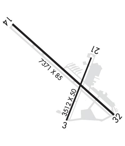
| Lat: N 4011.2 Long: W 07407.5 Elev: 153 Var: +12 Longest Runway: 7345 | ||
| Clr Del: 126.15 AWOS: 121.62 CTAF: 123.0 | ||
| ||||||||||||||||||||||||||||||||||||||||||||
| ||||||||||||||||||||||||||||||||||||||||||||
| ||||||||||||||||||||||||||||||||||||||||||||
| Rwy | Rwy | |||||||
| 3508x50 | 3508' | 3508x50 | 3508' | |||||
| 7345x85 | 7345' | 109.75 - 144° | 7345x85 | 7345' | ||||
| Runway ID | Single Wheel | Double Wheel | Double Tandem Wheel | Dual Double Wheel |
| 03/21 | N/A | N/A | N/A | N/A |
| 14/32 | N/A | N/A | N/A | N/A |
| These numbers are Advisory and are not limits. The Airport Manager should have more accurate Weight Limits | ||||
 Airport Diagram might not be current. | |
| Facility Name: | MONMOUTH EXEC |
| City Name: | BELMAR/FARMINGDALE |
| County: | MONMOUTH |
| State abbrev: | NJ |
| State Name: | NEW JERSEY |
| Ownership: | PRIVATELY OWNED |
| Use: | OPEN TO THE PUBLIC |
| Owner's Name: | WALL AVIATION |
| Address: | 1717 STATE RD 34, BLDG 5 |
| FARMINGDALE, NJ 07727 | |
| Owner's Phone: | 732-938-4800 |
| Manager's Name: | ALAN ANTAKI |
| Address: | 1717 STATE RD 34, BLDG 5 |
| FARMINGDALE, NJ 07727 | |
| Phone: | 732-751-0044 |
| FAA Region: | EASTERN |
| FAA Field Office: | HAR |
| Date | Sunrise | Sunset |
|---|---|---|
| 06/08/26 Monday | 5:27 | 20:24 |
| 06/09/26 Tuesday | 5:27 | 20:25 |
| 06/10/26 Wednesday | 5:27 | 20:25 |
| 06/11/26 Thursday | 5:27 | 20:26 |
| 06/12/26 Friday | 5:26 | 20:26 |
| 06/13/26 Saturday | 5:26 | 20:27 |
| 06/14/26 Sunday | 5:26 | 20:27 |
| 06/15/26 Monday | 5:26 | 20:28 |
| 06/16/26 Tuesday | 5:26 | 20:28 |
| 06/17/26 Wednesday | 5:27 | 20:28 |
| 06/18/26 Thursday | 5:27 | 20:29 |
| 06/19/26 Friday | 5:27 | 20:29 |
| 06/20/26 Saturday | 5:27 | 20:29 |
| 06/21/26 Sunday | 5:27 | 20:29 |
| Airport Attendance Schedule | CONTINUOUS |
| Airport Status | OPERATIONAL (This Status can change at any time - please check NOTAMS) |
| Airport Lighting Schedule | SS-SR |
| Airport Storage Available | Tie Downs, Hanger |
| Extra Services Available | Charter, Flight Instruction, Aircraft Rental |
| Wind Indicator | YES - (lighted) |
| Control Tower | NO |
| CTAF Frequency | 123.000 |
| Unicom Frequency | 123.000 |
| Rotating Beacon Color | WG |
| Segmented Circle | NO |
| Landing Fee | YES |
| Airport Inspected | STATE - performed by STATE AERONAUTICAL PERSONNEL |
| Inspection Date | 09/04/2025 |
| Type of Fuel Available | Grade 100LL, JET A (freeze point -40C); -A JET A AVBL 24 HRS.; -10SELF-SVC 100LL AVABL 24 HRS. |
| Airframe Repair Service | MINOR |
| Power Plant Repair Service | MINOR |
| Latitude | N4011.2 |
| Longitude | W07407.5 (ESTIMATED) |
| Arpt Elevation | 153ft (SURVEYED) |
| Magnetic Variation | 12W |
| 5 miles W | of BELMAR/FARMINGDALE |
| Traffic Pattern Altitude | |
| Sectional Chart | NEW YORK |
| Operations (Reported) | Yearly | Avg. Daily |
|---|---|---|
| General Aviation Transient | 0 | 0 |
| General Aviation Local | 0 | 0 |
| Air Taxi | 0 | 0 |
| Commerical | 0 | 0 |
| Commuter | 0 | 0 |
| Military | 0 | 0 |
| Aircraft based on Field | |
|---|---|
| General Aviation Singles | 0 |
| General Aviation Multi | 0 |
| Jet Aircraft | 0 |
| General Aviation Helicopters | 0 |
| Military Aircraft | 0 |
| Gliders | 0 |
| Ultralights | 0 |
| FSS on field | NO |
| FSS tie-in | MILLVILLE |
| FSS Phone | 1-800-WX-BRIEF |
| Who issues Notams | BLM |
| Notam D service at airport | YES |
| ARTCC Name | NEW YORK |
| Airport Certification | |
| Aircraft Rescue & Firefighting Index | None |
| Airport of Entry | No |
| Custom Landing Rights | No |
| Joint Civil/Military | No |
| Military Landing rights | YES |
| NATIONAL PLAN OF INTEGRATED AIRPORT SYSTEMS (NPIAS) |
| NO HELICOPTER ACTIVITY NE OF RY 14. HELICOPTER INSTRUCTION BY PRE-ARRANGEMENT ONLY 732-938-4800. |
| FOR CD CTC MC GUIRE APCH VIA FREQ, IF UNA CALL 609-754-2767. |
| ALL TSNT ACFT MUST GO TO FBO ON WEST SIDE OF ARPT. |
| NO TOUCH & GO LANDINGS FRI; SAT; SUN. |
| DEER & BIRDS ON & INVOF ARPT. |
| RY 14/32 NON-STD TWY SEPARATION 185 FT. |
| BERM 36 FT HIGH; NORTH RY 14/32 65 FT FROM CNTRLN. |
| TWYS NSTD MARKINGS. RY HOLD MARKINGS ON TWYS NSTD PLACEMENT. TWY LINES DO NOT ENSURE WING TIP/ROTOR CLEARANCE AT NW END OF PARALLEL TWY. |
| RWY 14/3 2 RWY 14/32 FIRST 575 FT AT AER 32 85 FT WIDE; REMAINDER RWY 14/32 100 FT WIDE |
| RWY 03/2 1 RWY 03/21 CLSD TO ACFT OVER 12500 LBS. |
| RWY 14/3 2 RWY 14/32 NSTD MIRLS; RWY 32 THLD LGTS NTSD. |
Airport Communications & Frequencies:
| ||||||||||||||||
| Runway: 03 | Runway: 21 | ||
| Mag heading: | 34° | Mag heading: | 214° |
| Rwy Slope: | -.05% Down | Rwy Slope: | .05% Up |
| Approach: | Approach: | ||
| Pattern: | Left Traffic | Pattern: | Left Traffic |
| Markings: | BASIC | Markings: | BASIC |
| Marking Condition: | GOOD | Marking Condition: | GOOD |
| Arresting Dev: | Arresting Dev: | ||
| Lat & Long: | N4010.8 W07407.5 | Lat. & Long.: | N4011.4 W07407.2 |
| Elev: | 148.7 ft. MSL | Elev: | 146.9 ft. MSL |
| TCH: | TCH: | ||
| Visual Glide Path: | Visual Glide Path: | ||
| Displaced Threshold: | No | Displaced Threshold: | No |
| Touchdown Zone: | YES | Touchdown Zone: | YES |
| Touchdown Elev.: | 148.7 feet | Touchdown Elev.: | 146.9 feet |
| Visual Glide Slope: | Visual Glide Slope: | ||
| RVR Equipment: | RVR Equipment: | ||
| RVV Equipment: | NO | RVV Equipment: | NO |
| Approach Lights: | Approach Lights: | ||
| REIL: | NO | REIL: | NO |
| Centerline Lights: | NO | Centerline Lights: | NO |
| Touchdown lights: | NO | Touchdown lights: | NO |
| Runway Category: | Runway with a Visual Approach | Runway Category: | Runway with a Visual Approach |
| Declared Distances: | Declared Distances: | ||
| Obstructions: | TREES | Obstructions: | TREE |
| Marked: | NOT Marked/Lighted | Marked: | NOT Marked/Lighted |
| Clearance slope: | 6:1 | Clearance slope: | |
| Obstruction height: | 43 feet AGL | Obstruction height: | 29 feet AGL |
| Dist. from runway: | 473 feet | Dist. from runway: | 210 feet |
| Centerline offset: | Centerline offset: | 75 feet right of centerline | |
| Comments: | +15 FT TREE 138 FT FM RWY END 13 FT R CNTRLN. | Comments: | RWY 21 32 FT POLE/BLDG 60 FT FROM THLD, 70 FT LEFT. |
| Runway: 14 | Runway: 32 | ||
| Mag heading: | 144° | Mag heading: | 324° |
| Rwy Slope: | .58% Up | Rwy Slope: | -.58% Down |
| Approach: | LOC/DME | Approach: | |
| Pattern: | Left Traffic | Pattern: | Left Traffic |
| Markings: | PRECISION INSTRUMENT | Markings: | NONSTANDARD |
| Marking Condition: | GOOD | Marking Condition: | GOOD |
| Arresting Dev: | Arresting Dev: | ||
| Lat & Long: | N4011.7 W07408.1 | Lat. & Long.: | N4010.8 W07407.0 |
| Elev: | 109.9 ft. MSL | Elev: | 152.6 ft. MSL |
| TCH: | TCH: | ||
| Visual Glide Path: | Visual Glide Path: | ||
| Displaced Threshold: | No | Displaced Threshold: | No |
| Touchdown Zone: | YES | Touchdown Zone: | YES |
| Touchdown Elev.: | 119.1 feet | Touchdown Elev.: | 153.4 feet |
| Visual Glide Slope: | Visual Glide Slope: | ||
| RVR Equipment: | RVR Equipment: | ||
| RVV Equipment: | NO | RVV Equipment: | NO |
| Approach Lights: | Approach Lights: | ||
| REIL: | YES | REIL: | NO |
| Centerline Lights: | NO | Centerline Lights: | NO |
| Touchdown lights: | NO | Touchdown lights: | NO |
| Runway Category: | Runway with a Non-precision Approach having visibility minimums greater than 3/4 mile | Runway Category: | Runway with a Non-precision Approach having visibility minimums greater than 3/4 mile |
| Declared Distances: | Declared Distances: | ||
| Obstructions: | TREES | Obstructions: | TREES |
| Marked: | NOT Marked/Lighted | Marked: | NOT Marked/Lighted |
| Clearance slope: | 20:1; OBSTN CLNC SLOPE 20:1 TO THRESHOLD | Clearance slope: | 20:1; OBSTN CLNC SLOPE 20:1 TO THRESHOLD |
| Obstruction height: | 30 feet AGL | Obstruction height: | 27 feet AGL |
| Dist. from runway: | 807 feet | Dist. from runway: | 774 feet |
| Centerline offset: | 243 left of centerline | Centerline offset: | |
| Comments: | Comments: |
Thanks for using FltPlan.com
all rights reserved © 1999-2026 by Flight Plan LLC
