| BROOKINGS RGNL BROOKINGS SD |
| |
| Lat: N 4418.3 Long: W 09649.1 Elev: 1648 Var: -03 Longest Runway: 6000 | ||
| AWOS: 119.92 CTAF: 123.0 | ||
| |||||||||||||||||||||||||||||||||||||||||||||||||||||||||||||||||||||
| |||||||||||||||||||||||||||||||||||||||||||||||||||||||||||||||||||||
| |||||||||||||||||||||||||||||||||||||||||||||||||||||||||||||||||||||
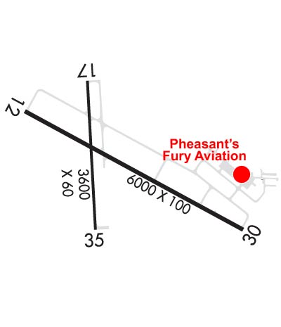
| Rwy | Rwy | |||||||
| 6000x100 | 6000' | 111.35 - 115° | 6000x100 | 6000' | ||||
| 3600x60 | 3600' | 3600x60 | 3600' | |||||
| Runway ID | Single Wheel | Double Wheel | Double Tandem Wheel | Dual Double Wheel |
| 12/30 | 44,000 | 61,000 | 86,000 | N/A |
| 17/35 | 12,500 | N/A | N/A | N/A |
| These numbers are Advisory and are not limits. The Airport Manager should have more accurate Weight Limits | ||||
 Airport Diagram might not be current. | |
| Facility Name: | BROOKINGS RGNL |
| City Name: | BROOKINGS |
| County: | BROOKINGS |
| State abbrev: | SD |
| State Name: | SOUTH DAKOTA |
| Ownership: | PUBLICLY OWNED |
| Use: | OPEN TO THE PUBLIC |
| Owner's Name: | CITY OF BROOKINGS |
| Address: | 520 3RD STREET, SUITE 140, PO BOX 270 |
| BROOKINGS, SD 57006 | |
| Owner's Phone: | 605-692-6955 |
| Manager's Name: | MATTHEW SOMMERFELD |
| Address: | 509 W SECOND STREET |
| BROOKINGS, SD 57006 | |
| Phone: | 605-697-8664 |
| FAA Region: | GREAT LAKES |
| FAA Field Office: | DMA |
| Date | Sunrise | Sunset |
|---|---|---|
| 09/24/21 Friday | 7:16 | 19:21 |
| 09/25/21 Saturday | 7:18 | 19:19 |
| 09/26/21 Sunday | 7:19 | 19:18 |
| 09/27/21 Monday | 7:20 | 19:16 |
| 09/28/21 Tuesday | 7:21 | 19:14 |
| 09/29/21 Wednesday | 7:22 | 19:12 |
| 09/30/21 Thursday | 7:24 | 19:10 |
| 10/01/21 Friday | 7:25 | 19:08 |
| 10/02/21 Saturday | 7:26 | 19:07 |
| 10/03/21 Sunday | 7:27 | 19:05 |
| 10/04/21 Monday | 7:28 | 19:03 |
| 10/05/21 Tuesday | 7:30 | 19:01 |
| 10/06/21 Wednesday | 7:31 | 18:59 |
| 10/07/21 Thursday | 7:32 | 18:57 |
| Airport Attendance Schedule | 7 Days A Week 0800-1800 |
| Airport Status | OPERATIONAL (This Status can change at any time - please check NOTAMS) |
| Airport Lighting Schedule | ACTVT MALSR RWY 12; REIL RWY 17, 30, 35; PAPI RWY 12, 17, 30, 35; HIRL RWY 12/30; MIRL RWY 17/35 - CTAF |
| Airport Storage Available | Tie Downs, Hanger |
| Extra Services Available | Crop Dusting, Charter, Flight Instruction, Aircraft Rental |
| Wind Indicator | YES - (lighted) |
| Control Tower | NO |
| CTAF Frequency | 123.000 |
| Unicom Frequency | 123.000 |
| Rotating Beacon Color | CLEAR-GREEN (Light Land Airport) |
| Segmented Circle | NO |
| Landing Fee | NO |
| Airport Inspected | FEDERAL - performed by STATE AERONAUTICAL PERSONNEL |
| Inspection Date | 06/15/2021 |
| Type of Fuel Available | Grade 100LL, JET A (freeze point -40C) |
| Airframe Repair Service | MAJOR |
| Power Plant Repair Service | MAJOR |
| Latitude | N4418.3 |
| Longitude | W09649.1 (ESTIMATED) |
| Arpt Elevation | 1647ft (SURVEYED) |
| Magnetic Variation | 03E |
| 0 miles SW | of BROOKINGS |
| Traffic Pattern Altitude | |
| Sectional Chart | OMAHA |
| Operations (Reported) | Yearly | Avg. Daily |
|---|---|---|
| General Aviation Transient | 500 | 1 |
| General Aviation Local | 31000 | 85 |
| Air Taxi | 425 | 1 |
| Commerical | 0 | 0 |
| Commuter | 0 | 0 |
| Military | 100 | 0 |
| Aircraft based on Field | |
|---|---|
| General Aviation Singles | 54 |
| General Aviation Multi | 5 |
| Jet Aircraft | 0 |
| General Aviation Helicopters | 0 |
| Military Aircraft | 0 |
| Gliders | 3 |
| Ultralights | 0 |
| FSS on field | NO |
| FSS tie-in | HURON |
| FSS Phone | 1-800-WX-BRIEF |
| Who issues Notams | BKX |
| Notam D service at airport | YES |
| ARTCC Name | MINNEAPOLIS |
| Airport Certification | |
| Aircraft Rescue & Firefighting Index | None |
| Airport of Entry | No |
| Custom Landing Rights | No |
| Joint Civil/Military | No |
| Military Landing rights | YES |
| NATIONAL PLAN OF INTEGRATED AIRPORT SYSTEMS (NPIAS) |
| GRANT AGREEMENTS UNDER FAAP/ADAP/AIP |
| ASSURANCES PURSUANT TO TITLE VI, CIVIL RIGHTS ACT OF 1964 |
| INTENSIVE STUDENT TRAINING. |
| FOR CD IF UNA TO CTC ON FSS FREQ, CTC MINNEAPOLIS ARTCC AT 651-463-5588. |
| AIRFIELD CONDS NOT MNTD BTN 1900 - 0700 HRS LCL TIME. |
| LARGE FLOCKS OF GEESE & GULLS ON & INVOF ARPT APR THRU OCT. |
| FOR ATTENDANT AFT HRS CALL 605-692-2779 OR 605-690-6013. |
| GCO AVBL ON FREQ 121.725 (4 CLICKS TO MINNEAPOLIS CENTER, 6 CLICKS TO FLT SVC) |
Airport Communications & Frequencies:
| |||||||||
| Runway: 12 | Runway: 30 | ||
| Mag heading: | 116° | Mag heading: | 296° |
| Rwy Slope: | .57% Up | Rwy Slope: | -.57% Down |
| Approach: | ILS/DME | Approach: | |
| Pattern: | Left Traffic | Pattern: | Left Traffic |
| Markings: | PRECISION INSTRUMENT | Markings: | PRECISION INSTRUMENT |
| Marking Condition: | FAIR | Marking Condition: | FAIR |
| Arresting Dev: | Arresting Dev: | ||
| Lat & Long: | N4418.5 W09649.7 | Lat. & Long.: | N4418.0 W09648.4 |
| Elev: | 1602.6 ft. MSL | Elev: | 1636.7 ft. MSL |
| TCH: | 50 ft. AGL | TCH: | 35 ft. AGL |
| Visual Glide Path: | 3.00 degrees | Visual Glide Path: | 3.00 degrees |
| Displaced Threshold: | No | Displaced Threshold: | No |
| Touchdown Zone: | YES | Touchdown Zone: | YES |
| Touchdown Elev.: | 1620.6 feet | Touchdown Elev.: | 1636.7 feet |
| Visual Glide Slope: | 4-Light PAPI on LEFT side of Runway | Visual Glide Slope: | 4-Light PAPI on LEFT side of Runway |
| RVR Equipment: | RVR Equipment: | ||
| RVV Equipment: | NO | RVV Equipment: | NO |
| Approach Lights: | MALSR - 1,400 foot medium intensity approach lighting system with runway alignment indicator lights | Approach Lights: | |
| REIL: | NO | REIL: | YES |
| Centerline Lights: | NO | Centerline Lights: | NO |
| Touchdown lights: | NO | Touchdown lights: | NO |
| Runway Category: | Precision Instrument Runway | Runway Category: | D |
| Declared Distances: | TORA:6000' TODA:6000' ASDA:6000' LDA:6000' | Declared Distances: | TORA:6000' TODA:6000' ASDA:6000' LDA:6000' |
| Runway: 17 | Runway: 35 | ||
| Mag heading: | 174° | Mag heading: | 354° |
| Rwy Slope: | 1.00% Up | Rwy Slope: | -1.00% Down |
| Approach: | Approach: | ||
| Pattern: | Left Traffic | Pattern: | Left Traffic |
| Markings: | NONPRECISION INSTRUMENT | Markings: | NONPRECISION INSTRUMENT |
| Marking Condition: | GOOD | Marking Condition: | GOOD |
| Arresting Dev: | Arresting Dev: | ||
| Lat & Long: | N4418.6 W09649.3 | Lat. & Long.: | N4418.0 W09649.3 |
| Elev: | 1609.8 ft. MSL | Elev: | 1645.9 ft. MSL |
| TCH: | 25 ft. AGL | TCH: | 24 ft. AGL |
| Visual Glide Path: | 3.00 degrees | Visual Glide Path: | 3.00 degrees |
| Displaced Threshold: | No | Displaced Threshold: | No |
| Touchdown Zone: | YES | Touchdown Zone: | YES |
| Touchdown Elev.: | 1635.2 feet | Touchdown Elev.: | 1647.5 feet |
| Visual Glide Slope: | 2-Light PAPI on LEFT side of Runway | Visual Glide Slope: | 2-Light PAPI on LEFT side of Runway |
| RVR Equipment: | RVR Equipment: | ||
| RVV Equipment: | NO | RVV Equipment: | NO |
| Approach Lights: | Approach Lights: | ||
| REIL: | YES | REIL: | YES |
| Centerline Lights: | NO | Centerline Lights: | NO |
| Touchdown lights: | NO | Touchdown lights: | NO |
| Runway Category: | Runway with a Visual Approach | Runway Category: | Runway with a Visual Approach |
| Declared Distances: | TORA:3600' TODA:3600' ASDA:3600' LDA:3600' | Declared Distances: | TORA:3600' TODA:3600' ASDA:3600' LDA:3600' |
Thanks for using FltPlan.com
all rights reserved © 1999-2021 by Flight Plan LLC