| RALEIGH COUNTY MEMORIAL BECKLEY WV |
| |
| Lat: N 3747.2 Long: W 08107.5 Elev: 2504 Var: +06 Longest Runway: 6750 | ||
| AWOS: 121.55 CTAF: 123.0 | ||
| ||||||
| ||||||
|
| FBOs at nearby airports who want your business: | |||||||||||||||||
| |||||||||||||||||
| Rwy | Rwy | |||||||
| 6750x150 | 6750' | 6750x150 | 6750' | 111.70 - 193° | ||||
| 5001x100 | 5001' | 5001x100 | 5001' | |||||
| Runway ID | Single Wheel | Double Wheel | Double Tandem Wheel | Dual Double Wheel |
| 01/19 | 75,000 | 150,000 | 200,000 | N/A |
| 10/28 | 45,000 | 60,000 | N/A | N/A |
| These numbers are Advisory and are not limits. The Airport Manager should have more accurate Weight Limits | ||||
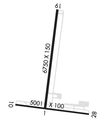 Airport Diagram might not be current. | |
| Facility Name: | RALEIGH COUNTY MEML |
| City Name: | BECKLEY |
| County: | RALEIGH |
| State abbrev: | WV |
| State Name: | WEST VIRGINIA |
| Ownership: | PUBLICLY OWNED |
| Use: | OPEN TO THE PUBLIC |
| Owner's Name: | RALEIGH COUNTY ARPT AUTH |
| Address: | 176 AIRPORT CIRCLE RM 105 |
| BEAVER, WV 25813 | |
| Owner's Phone: | 304-255-0476 |
| Manager's Name: | TOM COCHRAN |
| Address: | 176 AIRPORT CIRCLE RM 105 |
| BEAVER, WV 25813 | |
| Phone: | 304-255-0476 |
| FAA Region: | EASTERN |
| FAA Field Office: | BKW |
| Date | Sunrise | Sunset |
|---|---|---|
| 09/24/21 Friday | 7:14 | 19:19 |
| 09/25/21 Saturday | 7:15 | 19:17 |
| 09/26/21 Sunday | 7:15 | 19:16 |
| 09/27/21 Monday | 7:16 | 19:14 |
| 09/28/21 Tuesday | 7:17 | 19:13 |
| 09/29/21 Wednesday | 7:18 | 19:11 |
| 09/30/21 Thursday | 7:19 | 19:09 |
| 10/01/21 Friday | 7:20 | 19:08 |
| 10/02/21 Saturday | 7:21 | 19:06 |
| 10/03/21 Sunday | 7:22 | 19:05 |
| 10/04/21 Monday | 7:23 | 19:03 |
| 10/05/21 Tuesday | 7:23 | 19:02 |
| 10/06/21 Wednesday | 7:24 | 19:00 |
| 10/07/21 Thursday | 7:25 | 18:59 |
| Airport Attendance Schedule | CONTINUOUS |
| Airport Status | OPERATIONAL (This Status can change at any time - please check NOTAMS) |
| Airport Lighting Schedule | ACTVT MALSR RWY 19; REIL RWY 01, 10 & 28; VASI RWY 10 & 28; MIRL RWY 10/28; HIRL RWY 01/19; TWY LGTS - CTAF. PAPI RWY 01 & 19 SET AT MEDIUM, CTC UNICOM TO CHANGE INTST. |
| Airport Storage Available | Tie Downs, Hanger |
| Extra Services Available | Air Ambulance, Cargo Handling, Charter, Flight Instruction, Aircraft Rental |
| Wind Indicator | YES - (lighted) |
| Control Tower | NO |
| CTAF Frequency | 123.000 |
| Unicom Frequency | 123.000 |
| Rotating Beacon Color | CLEAR-GREEN (Light Land Airport) |
| Segmented Circle | NO |
| Landing Fee | NO |
| Airport Inspected | FEDERAL - performed by FAA AIRPORTS FIELD PERSONNEL |
| Inspection Date | 05/10/2021 |
| Type of Fuel Available | Grade 100LL, JET A (freeze point -40C) |
| Airframe Repair Service | MAJOR |
| Power Plant Repair Service | MAJOR |
| Latitude | N3747.2 |
| Longitude | W08107.5 (ESTIMATED) |
| Arpt Elevation | 2503ft (SURVEYED) |
| Magnetic Variation | 06W |
| 3 miles E | of BECKLEY |
| Traffic Pattern Altitude | |
| Sectional Chart | CINCINNATI |
| Operations (Reported) | Yearly | Avg. Daily |
|---|---|---|
| General Aviation Transient | 9200 | 25 |
| General Aviation Local | 8820 | 24 |
| Air Taxi | 1481 | 4 |
| Commerical | 0 | 0 |
| Commuter | 0 | 0 |
| Military | 2850 | 8 |
| Aircraft based on Field | |
|---|---|
| General Aviation Singles | 19 |
| General Aviation Multi | 8 |
| Jet Aircraft | 3 |
| General Aviation Helicopters | 1 |
| Military Aircraft | 0 |
| Gliders | 0 |
| Ultralights | 0 |
| FSS on field | NO |
| FSS tie-in | ELKINS |
| FSS Phone | 1-800-WX-BRIEF |
| Who issues Notams | BKW |
| Notam D service at airport | YES |
| ARTCC Name | INDIANAPOLIS |
| Airport Certification | AIRPORT RECEIVING SCHEDULED AIR CARRIER SERVICE FROM CARRIERS CERTIFICATED BY THE CIVIL AERONAUTICS BOARD; PPR 24 HRS FOR UNSKED ACR OPNS WITH MORE THAN 30 PSGR SEATS; CALL AMGR 304-255-0476. |
| Aircraft Rescue & Firefighting Index | AIRPORT HAS A CERTIFICATE UNDER CFR PART 139 |
| Airport of Entry | No |
| Custom Landing Rights | No |
| Joint Civil/Military | No |
| Military Landing rights | YES |
| NATIONAL PLAN OF INTEGRATED AIRPORT SYSTEMS (NPIAS) |
| GRANT AGREEMENTS UNDER FAAP/ADAP/AIP |
| ASSURANCES PURSUANT TO TITLE VI, CIVIL RIGHTS ACT OF 1964 |
| THIS AIRPORT HAS BEEN SURVEYED BY THE NATIONAL GEODETIC SURVEY. |
| DEER; BIRDS & WILD TURKEYS ON & INVOF ARPT. |
Airport Communications & Frequencies:
| ||||||||||||||
| Runway: 01 | Runway: 19 | ||
| Mag heading: | 13° | Mag heading: | 193° |
| Rwy Slope: | -.69% Down | Rwy Slope: | .69% Up |
| Approach: | Approach: | ILS | |
| Pattern: | Left Traffic | Pattern: | Left Traffic |
| Markings: | NONPRECISION INSTRUMENT | Markings: | PRECISION INSTRUMENT |
| Marking Condition: | GOOD | Marking Condition: | GOOD |
| Arresting Dev: | Arresting Dev: | ||
| Lat & Long: | N3746.9 W08107.5 | Lat. & Long.: | N3748.0 W08107.4 |
| Elev: | 2495.3 ft. MSL | Elev: | 2448.8 ft. MSL |
| TCH: | 40 ft. AGL | TCH: | 55 ft. AGL |
| Visual Glide Path: | 3.00 degrees | Visual Glide Path: | 3.00 degrees |
| Displaced Threshold: | No | Displaced Threshold: | No |
| Touchdown Zone: | YES | Touchdown Zone: | YES |
| Touchdown Elev.: | 2495.4 feet | Touchdown Elev.: | 2468.2 feet |
| Visual Glide Slope: | 4-Light PAPI on LEFT side of Runway | Visual Glide Slope: | 4-Light PAPI on LEFT side of Runway |
| RVR Equipment: | RVR Equipment: | ||
| RVV Equipment: | NO | RVV Equipment: | NO |
| Approach Lights: | Approach Lights: | MALSR - 1,400 foot medium intensity approach lighting system with runway alignment indicator lights | |
| REIL: | YES | REIL: | NO |
| Centerline Lights: | NO | Centerline Lights: | NO |
| Touchdown lights: | NO | Touchdown lights: | NO |
| Runway Category: | Runway with a Non-precision Approach having visibility minimums greater than 3/4 mile | Runway Category: | Precision Instrument Runway |
| Declared Distances: | TORA:6750' TODA:6750' ASDA:6750' LDA:6750' | Declared Distances: | TORA:6750' TODA:6750' ASDA:6750' LDA:6750' |
| Runway: 10 | Runway: 28 | ||
| Mag heading: | 104° | Mag heading: | 284° |
| Rwy Slope: | .30% Up | Rwy Slope: | -.30% Down |
| Approach: | Approach: | ||
| Pattern: | Left Traffic | Pattern: | Left Traffic |
| Markings: | NONPRECISION INSTRUMENT | Markings: | NONPRECISION INSTRUMENT |
| Marking Condition: | GOOD | Marking Condition: | GOOD |
| Arresting Dev: | Arresting Dev: | ||
| Lat & Long: | N3747.0 W08108.0 | Lat. & Long.: | N3746.9 W08106.9 |
| Elev: | 2485.7 ft. MSL | Elev: | 2500.8 ft. MSL |
| TCH: | 61 ft. AGL | TCH: | 66 ft. AGL |
| Visual Glide Path: | 3.00 degrees | Visual Glide Path: | 3.75 degrees |
| Displaced Threshold: | No | Displaced Threshold: | No |
| Touchdown Zone: | YES | Touchdown Zone: | YES |
| Touchdown Elev.: | 2501.9 feet | Touchdown Elev.: | 2503.8 feet |
| Visual Glide Slope: | 4-BOX VASI ON RIGHT SIDE OF RUNWAY | Visual Glide Slope: | 4-BOX VASI ON LEFT SIDE OF RUNWAY; VGSI AND DESCENT ANGLES NOT COINCIDENT. |
| RVR Equipment: | RVR Equipment: | ||
| RVV Equipment: | NO | RVV Equipment: | NO |
| Approach Lights: | Approach Lights: | ||
| REIL: | YES | REIL: | YES |
| Centerline Lights: | NO | Centerline Lights: | NO |
| Touchdown lights: | NO | Touchdown lights: | NO |
| Runway Category: | Runway with a Non-precision Approach having visibility minimums greater than 3/4 mile | Runway Category: | Runway with a Non-precision Approach having visibility minimums greater than 3/4 mile |
| Declared Distances: | TORA:5001' TODA:5001' ASDA:5001' LDA:5001' | Declared Distances: | TORA:5001' TODA:5001' ASDA:5001' LDA:5001' |
| Comments: | Comments: | 9 FT OBSTRUCTION LIGHTED POLE, 125 FT FM AER, 250 FT RT. |
Thanks for using FltPlan.com
all rights reserved © 1999-2021 by Flight Plan LLC