
| ALLEN C PERKINSON/BAAF BLACKSTONE VA |
| |
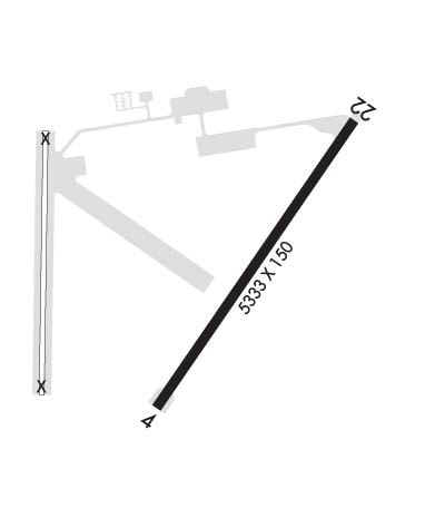
| Lat: N 3704.5 Long: W 07757.4 Elev: 437 Var: +09 Longest Runway: 5333 | ||
| AWOS: 119.22 Tower: 126.2 | ||
| ||||||||||||||||||||||||||||||||||||||||||||
| ||||||||||||||||||||||||||||||||||||||||||||
| ||||||||||||||||||||||||||||||||||||||||||||
| Rwy | Rwy | |||||||
| 5333x150 | 5333' | 5333x150 | 4633' | |||||
| Runway ID | Single Wheel | Double Wheel | Double Tandem Wheel | Dual Double Wheel |
| 04/22 | N/A | N/A | N/A | N/A |
| These numbers are Advisory and are not limits. The Airport Manager should have more accurate Weight Limits | ||||
 Airport Diagram might not be current. | |
| Facility Name: | ALLEN C PERKINSON BLACKSTONE AAF |
| City Name: | BLACKSTONE |
| County: | NOTTOWAY |
| State abbrev: | VA |
| State Name: | VIRGINIA |
| Ownership: | ARMY OWNED |
| Use: | OPEN TO THE PUBLIC |
| Owner's Name: | TOWN OF BLACKSTONE & US ARMY; C/O PHILIP VANNOORBEECK TOWN MANAGER. |
| Address: | 100 W ELM ST |
| BLACKSTONE, VA 23824 | |
| Owner's Phone: | 434-292-7251 |
| Manager's Name: | WALTER G. TISDALE |
| Address: | 49 DOMINY CORNER ROAD |
| BLACKSTONE, VA 23824 | |
| Phone: | 434-292-2193 |
| FAA Region: | EASTERN |
| FAA Field Office: | DCA |
| Date | Sunrise | Sunset |
|---|---|---|
| 09/24/21 Friday | 7:01 | 19:06 |
| 09/25/21 Saturday | 7:02 | 19:05 |
| 09/26/21 Sunday | 7:03 | 19:03 |
| 09/27/21 Monday | 7:04 | 19:02 |
| 09/28/21 Tuesday | 7:04 | 19:00 |
| 09/29/21 Wednesday | 7:05 | 18:58 |
| 09/30/21 Thursday | 7:06 | 18:57 |
| 10/01/21 Friday | 7:07 | 18:55 |
| 10/02/21 Saturday | 7:08 | 18:54 |
| 10/03/21 Sunday | 7:09 | 18:53 |
| 10/04/21 Monday | 7:10 | 18:51 |
| 10/05/21 Tuesday | 7:10 | 18:50 |
| 10/06/21 Wednesday | 7:11 | 18:48 |
| 10/07/21 Thursday | 7:12 | 18:47 |
| Airport Attendance Schedule | MON-FRI 0800-1800; CLSD FEDERAL HOLS. |
| Airport Status | OPERATIONAL (This Status can change at any time - please check NOTAMS) |
| Airport Lighting Schedule | WHEN ATCT CLSD ACTVT MIRL RWY 04/22 - CTAF. |
| Airport Storage Available | Tie Downs, Hanger |
| Extra Services Available | NONE |
| Wind Indicator | YES - (lighted) |
| Control Tower | YES |
| CTAF Frequency | 126.200 |
| Unicom Frequency | |
| Rotating Beacon Color | CLEAR-GREEN (Light Land Airport) |
| Segmented Circle | YES |
| Landing Fee | NO |
| Airport Inspected | STATE - performed by STATE AERONAUTICAL PERSONNEL |
| Inspection Date | 01/14/2021 |
| Type of Fuel Available | Grade 100LL, JET A (freeze point -40C); -10SELF SVC FUEL (100LL) AVBL 24 HRS; J8 (MIL) AVBL 24 HRS BY REQUEST. |
| Airframe Repair Service | NONE |
| Power Plant Repair Service | NONE |
| Latitude | N3704.5 |
| Longitude | W07757.4 (ESTIMATED) |
| Arpt Elevation | 437ft (SURVEYED) |
| Magnetic Variation | 09W |
| 2 miles E | of BLACKSTONE |
| Traffic Pattern Altitude | |
| Sectional Chart | WASHINGTON |
| Operations (Reported) | Yearly | Avg. Daily |
|---|---|---|
| General Aviation Transient | 78 | 0 |
| General Aviation Local | 288 | 1 |
| Air Taxi | 0 | 0 |
| Commerical | 0 | 0 |
| Commuter | 0 | 0 |
| Military | 920 | 3 |
| Aircraft based on Field | |
|---|---|
| General Aviation Singles | 9 |
| General Aviation Multi | 0 |
| Jet Aircraft | 0 |
| General Aviation Helicopters | 0 |
| Military Aircraft | 0; ACFT ON FLD DURING SUMMER EXERCISES |
| Gliders | 0 |
| Ultralights | 3 |
| FSS on field | NO |
| FSS tie-in | LEESBURG |
| FSS Phone | 1-800-WX-BRIEF |
| Who issues Notams | DCA |
| Notam D service at airport | YES |
| ARTCC Name | WASHINGTON |
| Airport Certification | |
| Aircraft Rescue & Firefighting Index | None |
| Airport of Entry | No |
| Custom Landing Rights | No |
| Joint Civil/Military | YES |
| Military Landing rights | No |
| AGREEMENT UNDER DLAND OR DCLA HAS EXPIRED. |
| AVOID FLT BLW 500 FT OVR AMMUNITION SUP POINT 1 NM S OF ARPT. |
| CRASH/RESCUE SVC C434-292-2217. |
| DEER AT TIMES NEAR RWY AND ON ARPT. |
| NO PPR RQRD FOR CIV ACFT. |
| SVC: C434-292-4914, OT 434-294-7558. |
| RWY 22 HAS 700 FT DISPLACED THLD. |
| APGU AVBL DURING DUTY HOURS. |
| WHEN ATCT CLSD, FOR CD CTC WASHINGTON ARTCC AT 703-771-3587. |
| CLOSED X FOR CHARLIE TWY PAST ENTRANCE TO CHARLIE RAMP. |
| CLOSED X FOR HELIPAD. |
| CTC AIRFIELD OPNS ACTIVITY FT PICKETT 434-292-8589 FOR PPR. |
| JET AND MIL TRNG WITHIN 20 NM RADIUS. EXTN C130 TFC AND FREQ PRCHT DROPS. |
Airport Communications & Frequencies:
| |||||||||||||||
| Runway: 04 | Runway: 22 | ||
| Mag heading: | 44° | Mag heading: | 224° |
| Rwy Slope: | .66% Up | Rwy Slope: | -.66% Down |
| Approach: | Approach: | ||
| Pattern: | Left Traffic | Pattern: | Left Traffic |
| Markings: | NONPRECISION INSTRUMENT | Markings: | NONPRECISION INSTRUMENT |
| Marking Condition: | POOR; RWY MARKINGS IN POOR CONDITION. | Marking Condition: | POOR; RWY MARKINGS IN POOR CONDITION. DISPLACED THRESHOLD POOR VISIBILITY. HOLD SHORT LINE POOR VISIBILITY |
| Arresting Dev: | Arresting Dev: | ||
| Lat & Long: | N3704.1 W07757.4 | Lat. & Long.: | N3704.8 W07756.8 |
| Elev: | 400.2 ft. MSL | Elev: | 435.4 ft. MSL |
| TCH: | TCH: | ||
| Visual Glide Path: | Visual Glide Path: | ||
| Displaced Threshold: | No | Displaced Threshold: | 700 feet |
| Touchdown Zone: | YES | Touchdown Zone: | YES |
| Touchdown Elev.: | 427.5 feet | Touchdown Elev.: | 437.4 feet |
| Visual Glide Slope: | Visual Glide Slope: | ||
| RVR Equipment: | RVR Equipment: | ||
| RVV Equipment: | NO | RVV Equipment: | NO |
| Approach Lights: | Approach Lights: | ||
| REIL: | NO | REIL: | NO |
| Centerline Lights: | NO | Centerline Lights: | NO |
| Touchdown lights: | NO | Touchdown lights: | NO |
| Runway Category: | Runway with a Non-precision Approach having visibility minimums greater than 3/4 mile | Runway Category: | Runway with a Non-precision Approach having visibility minimums greater than 3/4 mile |
| Declared Distances: | Declared Distances: | ||
| Obstructions: | TREE | Obstructions: | TREE |
| Marked: | NOT Marked/Lighted | Marked: | NOT Marked/Lighted |
| Clearance slope: | 22:1 | Clearance slope: | 16:1; OBSTN CLNC 18:1 AT DSPLCD THLD. |
| Obstruction height: | 84 feet AGL | Obstruction height: | 69 feet AGL |
| Dist. from runway: | 2102 feet | Dist. from runway: | 1342 feet |
| Centerline offset: | 342 right of centerline | Centerline offset: | 380 feet right of centerline |
| Comments: | Comments: |
Thanks for using FltPlan.com
all rights reserved © 1999-2021 by Flight Plan LLC
