
| BROOKS COUNTY FALFURRIAS TX |
| |
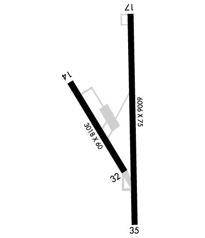
| Lat: N 2712.4 Long: W 09807.3 Elev: 112 Var: -06 Longest Runway: 6006 | ||
| AWOS: 118.12 CTAF: 122.8 | ||
| ||||||||||||||||||||||||||||||||||||||||||||
| ||||||||||||||||||||||||||||||||||||||||||||
| ||||||||||||||||||||||||||||||||||||||||||||
| Rwy | Rwy | |||||||
| 3018x60 | 3018' | 3018x60 | 3018' | |||||
| 6006x75 | 6006' | 6006x75 | 6006' | |||||
| Runway ID | Single Wheel | Double Wheel | Double Tandem Wheel | Dual Double Wheel |
| 14/32 | 4,000 | N/A | N/A | N/A |
| 17/35 | 52,000 | 80,000 | N/A | N/A |
| These numbers are Advisory and are not limits. The Airport Manager should have more accurate Weight Limits | ||||
 Airport Diagram might not be current. | |
| Facility Name: | BROOKS COUNTY |
| City Name: | FALFURRIAS |
| County: | BROOKS |
| State abbrev: | TX |
| State Name: | TEXAS |
| Ownership: | PUBLICLY OWNED |
| Use: | OPEN TO THE PUBLIC |
| Owner's Name: | BROOKS COUNTY |
| Address: | CO COMMISSIONERS COURT |
| FALFURRIAS, TX 78355 | |
| Owner's Phone: | 361-325-5604 |
| Manager's Name: | BOND COSBY |
| Address: | PO BOX 556 |
| FALFURRIAS, TX 78355 | |
| Phone: | 361-325-2909; 361-850-3430 OR FROM NOV-FEB ON CALL 24/7 |
| FAA Region: | SOUTHWEST |
| FAA Field Office: | TEX |
| Date | Sunrise | Sunset |
|---|---|---|
| 09/24/21 Friday | 7:22 | 19:27 |
| 09/25/21 Saturday | 7:22 | 19:26 |
| 09/26/21 Sunday | 7:23 | 19:25 |
| 09/27/21 Monday | 7:23 | 19:23 |
| 09/28/21 Tuesday | 7:24 | 19:22 |
| 09/29/21 Wednesday | 7:24 | 19:21 |
| 09/30/21 Thursday | 7:25 | 19:20 |
| 10/01/21 Friday | 7:25 | 19:19 |
| 10/02/21 Saturday | 7:25 | 19:18 |
| 10/03/21 Sunday | 7:26 | 19:17 |
| 10/04/21 Monday | 7:26 | 19:16 |
| 10/05/21 Tuesday | 7:27 | 19:14 |
| 10/06/21 Wednesday | 7:27 | 19:13 |
| 10/07/21 Thursday | 7:28 | 19:12 |
| Airport Attendance Schedule | MAR-OCT MON-FRI 0900-1600, NOV-FEB 7 Days A Week 0900-1700; FOR ATTENDANT AFT HRS CALL 361-325-2909. |
| Airport Status | OPERATIONAL (This Status can change at any time - please check NOTAMS) |
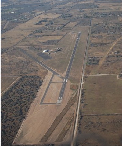
| Airport Lighting Schedule | MIRL RWY 17/35 PRESET LOW INTST. TO INCR INTST & ACTVT REIL RWY 17; PAPI RWYS 17 & 35 - CTAF. |
| Airport Storage Available | Tie Downs |
| Extra Services Available | NONE |
| Wind Indicator | YES - (lighted) |
| Control Tower | NO |
| CTAF Frequency | 122.800 |
| Unicom Frequency | 122.800 |
| Rotating Beacon Color | CLEAR-GREEN (Light Land Airport) |
| Segmented Circle | YES |
| Landing Fee | NO |
| Airport Inspected | STATE - performed by STATE AERONAUTICAL PERSONNEL |
| Inspection Date | 01/10/2017 |
| Type of Fuel Available | Grade 100LL, JET A (freeze point -40C) |
| Airframe Repair Service | NONE |
| Power Plant Repair Service | NONE |
| Latitude | N2712.4 |
| Longitude | W09807.3 (ESTIMATED) |
| Arpt Elevation | 111ft (SURVEYED) |
| Magnetic Variation | 06E |
| 2 miles SE | of FALFURRIAS |
| Traffic Pattern Altitude | |
| Sectional Chart | BROWNSVILLE |
| Operations (Reported) | Yearly | Avg. Daily |
|---|---|---|
| General Aviation Transient | 5000 | 14 |
| General Aviation Local | 450 | 1 |
| Air Taxi | 0 | 0 |
| Commerical | 0 | 0 |
| Commuter | 0 | 0 |
| Military | 2500 | 7 |
| Aircraft based on Field | |
|---|---|
| General Aviation Singles | 0 |
| General Aviation Multi | 0 |
| Jet Aircraft | 0 |
| General Aviation Helicopters | 1 |
| Military Aircraft | 0 |
| Gliders | 0 |
| Ultralights | 0 |
| FSS on field | NO |
| FSS tie-in | SAN ANGELO |
| FSS Phone | 1-800-WX-BRIEF |
| Who issues Notams | BKS |
| Notam D service at airport | YES |
| ARTCC Name | HOUSTON |
| Airport Certification | |
| Aircraft Rescue & Firefighting Index | None |
| Airport of Entry | No |
| Custom Landing Rights | No |
| Joint Civil/Military | No |
| Military Landing rights | YES |
| NATIONAL PLAN OF INTEGRATED AIRPORT SYSTEMS (NPIAS) |
| GRANT AGREEMENTS UNDER FAAP/ADAP/AIP |
| ASSURANCES PURSUANT TO TITLE VI, CIVIL RIGHTS ACT OF 1964 |
| 9 FT FENCE LCTD APRX 900 FT NORTH OF RWY 17. |
| FOR CD CTC HOUSTON ARTCC AT 281-230-5622. |
| RWY 14/3 2 SINGLE WHEEL 18000 LBS. |
Airport Communications & Frequencies:
| |||||||||||||||||
| Runway: 14 | Runway: 32 | ||
| Mag heading: | 143° | Mag heading: | 323° |
| Rwy Slope: | .00% | Rwy Slope: | .00% |
| Approach: | Approach: | ||
| Pattern: | Left Traffic | Pattern: | Left Traffic |
| Markings: | BASIC | Markings: | BASIC |
| Marking Condition: | GOOD | Marking Condition: | GOOD |
| Arresting Dev: | Arresting Dev: | ||
| Lat & Long: | N2712.5 W09807.5 | Lat. & Long.: | N2712.1 W09807.2 |
| Elev: | 110.8 ft. MSL | Elev: | 110.8 ft. MSL |
| TCH: | TCH: | ||
| Visual Glide Path: | Visual Glide Path: | ||
| Displaced Threshold: | No | Displaced Threshold: | No |
| Touchdown Zone: | YES | Touchdown Zone: | YES |
| Touchdown Elev.: | 110.8 feet | Touchdown Elev.: | 110.8 feet |
| Visual Glide Slope: | Visual Glide Slope: | ||
| RVR Equipment: | RVR Equipment: | ||
| RVV Equipment: | NO | RVV Equipment: | NO |
| Approach Lights: | Approach Lights: | ||
| REIL: | NO | REIL: | NO |
| Centerline Lights: | NO | Centerline Lights: | NO |
| Touchdown lights: | NO | Touchdown lights: | NO |
| Runway Category: | Runway with a Visual Approach | Runway Category: | Runway with a Visual Approach |
| Declared Distances: | Declared Distances: | ||
| Obstructions: | TREES | Obstructions: | TREES |
| Marked: | NOT Marked/Lighted | Marked: | NOT Marked/Lighted |
| Clearance slope: | 12:1 | Clearance slope: | 20:1 |
| Obstruction height: | 26 feet AGL | Obstruction height: | 27 feet AGL |
| Dist. from runway: | 534 feet | Dist. from runway: | 744 feet |
| Centerline offset: | 75 left of centerline | Centerline offset: | |
| Comments: | +16 FT TREES FM THR TO 200 FT FM THR, 87 FT RIGHT. | Comments: |
| Runway: 17 | Runway: 35 | ||
| Mag heading: | 174° | Mag heading: | 354° |
| Rwy Slope: | -.01% Down | Rwy Slope: | .01% Up |
| Approach: | Approach: | ||
| Pattern: | Left Traffic | Pattern: | Left Traffic |
| Markings: | NONPRECISION INSTRUMENT | Markings: | NONPRECISION INSTRUMENT |
| Marking Condition: | GOOD | Marking Condition: | GOOD |
| Arresting Dev: | Arresting Dev: | ||
| Lat & Long: | N2712.9 W09807.2 | Lat. & Long.: | N2711.9 W09807.2 |
| Elev: | 111.4 ft. MSL | Elev: | 110.7 ft. MSL |
| TCH: | 45 ft. AGL | TCH: | 45 ft. AGL |
| Visual Glide Path: | 3.00 degrees | Visual Glide Path: | 3.00 degrees |
| Displaced Threshold: | No | Displaced Threshold: | No |
| Touchdown Zone: | YES | Touchdown Zone: | YES |
| Touchdown Elev.: | 111.4 feet | Touchdown Elev.: | 111.7 feet |
| Visual Glide Slope: | 4-Light PAPI on LEFT side of Runway | Visual Glide Slope: | 4-Light PAPI on LEFT side of Runway |
| RVR Equipment: | RVR Equipment: | ||
| RVV Equipment: | NO | RVV Equipment: | NO |
| Approach Lights: | Approach Lights: | ||
| REIL: | YES | REIL: | NO |
| Centerline Lights: | NO | Centerline Lights: | NO |
| Touchdown lights: | NO | Touchdown lights: | NO |
| Runway Category: | Runway with a Non-precision Approach having visibility minimums greater than 3/4 mile | Runway Category: | Runway with a Non-precision Approach having visibility minimums greater than 3/4 mile |
| Declared Distances: | Declared Distances: | ||
| Obstructions: | TREE | Obstructions: | |
| Marked: | NOT Marked/Lighted | Marked: | |
| Clearance slope: | 20:1 | Clearance slope: | 50:1 |
| Obstruction height: | 39 feet AGL | Obstruction height: | |
| Dist. from runway: | 1014 feet | Dist. from runway: | |
| Centerline offset: | 295 left of centerline | Centerline offset: | |
| Comments: | Comments: |
Thanks for using FltPlan.com
all rights reserved © 1999-2021 by Flight Plan LLC