
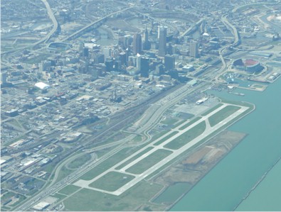
| BURKE LAKEFRONT CLEVELAND OH |
| |
| Lat: N 4131.1 Long: W 08141.0 Elev: 584 Var: +07 Longest Runway: 6604 | ||
| Clr Del: 121.9 TWR CL Dept. ATIS: 125.25 Arr. ATIS: 125.25 AWOS: 125.25 Ground: 121.9 Tower: 124.3 | ||
| ||||||||||||||||||||||||||||||||||||||||||||
| ||||||||||||||||||||||||||||||||||||||||||||
| ||||||||||||||||||||||||||||||||||||||||||||
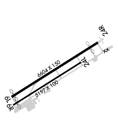
| Rwy | Rwy | |||||||
| 6604x150 | 6426' | 6604x150 | 6004' | 109.75 - 245° | ||||
| 5197x100 | 4922' | 5197x100 | 5197' | |||||
| Runway ID | Single Wheel | Double Wheel | Double Tandem Wheel | Dual Double Wheel |
| 06L/24R | 93,000 | 113,000 | 170,000 | N/A |
| 06R/24L | 43,000 | 50,000 | 82,000 | N/A |
| These numbers are Advisory and are not limits. The Airport Manager should have more accurate Weight Limits | ||||
 Airport Diagram might not be current. | |
| Facility Name: | BURKE LAKEFRONT |
| City Name: | CLEVELAND |
| County: | CUYAHOGA |
| State abbrev: | OH |
| State Name: | OHIO |
| Ownership: | PUBLICLY OWNED |
| Use: | OPEN TO THE PUBLIC |
| Owner's Name: | CITY OF CLEVELAND |
| Address: | 1501 N MARGINAL RD |
| CLEVELAND, OH 44114 | |
| Owner's Phone: | 216-781-6411 |
| Manager's Name: | KHALID BAHHUR |
| Address: | 1501 N MARGINAL RD |
| CLEVELAND, OH 44114 | |
| Phone: | 216-781-6411 |
| FAA Region: | GREAT LAKES |
| FAA Field Office: | DET |
| Date | Sunrise | Sunset |
|---|---|---|
| 09/24/21 Friday | 7:16 | 19:21 |
| 09/25/21 Saturday | 7:17 | 19:19 |
| 09/26/21 Sunday | 7:18 | 19:17 |
| 09/27/21 Monday | 7:19 | 19:16 |
| 09/28/21 Tuesday | 7:20 | 19:14 |
| 09/29/21 Wednesday | 7:21 | 19:12 |
| 09/30/21 Thursday | 7:22 | 19:11 |
| 10/01/21 Friday | 7:23 | 19:09 |
| 10/02/21 Saturday | 7:24 | 19:07 |
| 10/03/21 Sunday | 7:25 | 19:06 |
| 10/04/21 Monday | 7:26 | 19:04 |
| 10/05/21 Tuesday | 7:27 | 19:02 |
| 10/06/21 Wednesday | 7:29 | 19:01 |
| 10/07/21 Thursday | 7:30 | 18:59 |
| Airport Attendance Schedule | CONTINUOUS |
| Airport Status | OPERATIONAL (This Status can change at any time - please check NOTAMS) |
| Airport Lighting Schedule | WHEN ATCT CLSD ACTVT MALSF RWY 24R - CTAF. HIRL RWY 06L/24R PRESET MED INTST, TO INCR INTST RDO REQ ON UNICOM. |
| Airport Storage Available | Tie Downs, Hanger |
| Extra Services Available | Air Freight, Air Ambulance, Avionics, Cargo Handling, Charter, Flight Instruction |
| Wind Indicator | YES - (lighted) |
| Control Tower | YES |
| CTAF Frequency | 124.300 |
| Unicom Frequency | 122.950 |
| Rotating Beacon Color | CLEAR-GREEN (Light Land Airport) |
| Segmented Circle | Y-L |
| Landing Fee | YES; FEE SKED BASED ON NR OF ENGINES AND GWT. |
| Airport Inspected | FEDERAL - performed by FAA AIRPORTS FIELD PERSONNEL |
| Inspection Date | 08/26/2020 |
| Type of Fuel Available | Grade 100LL, JET A (freeze point -40C) |
| Airframe Repair Service | MAJOR |
| Power Plant Repair Service | MAJOR |
| Latitude | N4131.1 |
| Longitude | W08141.0 (ESTIMATED) |
| Arpt Elevation | 583ft (SURVEYED) |
| Magnetic Variation | 07W |
| 1 miles N | of CLEVELAND |
| Traffic Pattern Altitude | |
| Sectional Chart | DETROIT |
| Operations (Reported) | Yearly | Avg. Daily |
|---|---|---|
| General Aviation Transient | 16523 | 45 |
| General Aviation Local | 13883 | 38 |
| Air Taxi | 9358 | 26 |
| Commerical | 992 | 3 |
| Commuter | 0 | 0 |
| Military | 459 | 1 |
| Aircraft based on Field | |
|---|---|
| General Aviation Singles | 9 |
| General Aviation Multi | 0 |
| Jet Aircraft | 3 |
| General Aviation Helicopters | 5 |
| Military Aircraft | 0 |
| Gliders | 0 |
| Ultralights | 0 |
| FSS on field | NO |
| FSS tie-in | CLEVELAND |
| FSS Phone | 1-800-WX-BRIEF |
| Who issues Notams | BKL |
| Notam D service at airport | YES |
| ARTCC Name | CLEVELAND |
| Airport Certification | CLSD TO SKEDD ACR OPS GTR THAN 9 PAX SEATS. PPR FOR UNSKED ACR OPS WITH MORE THAN 30 PAX SEATS CALL AMGR. |
| Aircraft Rescue & Firefighting Index | AIRPORT HAS A CERTIFICATE UNDER CFR PART 139 |
| Airport of Entry | No |
| Custom Landing Rights | No |
| Joint Civil/Military | No |
| Military Landing rights | YES |
| NATIONAL PLAN OF INTEGRATED AIRPORT SYSTEMS (NPIAS) |
| GRANT AGREEMENTS UNDER FAAP/ADAP/AIP |
| ASSURANCES PURSUANT TO TITLE VI, CIVIL RIGHTS ACT OF 1964 |
| BIRDS AND WATERFOWL ON & INVOF ARPT. |
| FLIGHT NOTIFICATION SERVICE (ADCUS) AVBL 24 HRS MON-FRI REQ FOR SERVICE ON SAT; SUN & HOLS MUST BE MADE PRIOR TO 1630 ON FRI; 2 HRS ADVANCE NOTICE REQUIRED CALL 216-267-3600. PRIVATE ACFT & GENERAL AVIATION ONLY. |
| 72 FT SHIP CRANE 1300 FT SW OF RWY 06R. |
| FOR CD WHEN ATCT CLSD CTC CLEVELAND APCH AT 216-352-2323. |
| RWY 06R/ 24LCLSD TO UNSKED ACR OPS GTR THAN 30 PAX SEATS; CLSD WHEN ATCT CLSD. |
Airport Communications & Frequencies:
| ||||||||||||||||||||||||||||
| Runway: 06L | Runway: 24R | ||
| Mag heading: | 65° | Mag heading: | 245° |
| Rwy Slope: | .02% Up | Rwy Slope: | -.02% Down |
| Approach: | Approach: | ILS/DME | |
| Pattern: | Left Traffic | Pattern: | Right Traffic |
| Markings: | PRECISION INSTRUMENT | Markings: | PRECISION INSTRUMENT |
| Marking Condition: | GOOD | Marking Condition: | GOOD |
| Arresting Dev: | Arresting Dev: | EMAS | |
| Lat & Long: | N4130.8 W08141.5 | Lat. & Long.: | N4131.4 W08140.3 |
| Elev: | 581.1 ft. MSL | Elev: | 582.4 ft. MSL |
| TCH: | 45 ft. AGL | TCH: | 42 ft. AGL |
| Visual Glide Path: | 3.00 degrees | Visual Glide Path: | 3.00 degrees |
| Displaced Threshold: | 178 feet | Displaced Threshold: | 600 feet |
| Touchdown Zone: | YES | Touchdown Zone: | YES |
| Touchdown Elev.: | 582.8 feet | Touchdown Elev.: | 583.0 feet |
| Visual Glide Slope: | 4-Light PAPI on RIGHT side of Runway; UNUSBL BYD 5 DEGS RIGHT OF CNTRLN. | Visual Glide Slope: | 4-Light PAPI on RIGHT side of Runway; UNUSBL BYD 8 DEGS LEFT OF CRS. |
| RVR Equipment: | RVR Equipment: | ||
| RVV Equipment: | NO | RVV Equipment: | NO |
| Approach Lights: | Approach Lights: | MALSF - 1,400 foot medium intensity approach lighting system with sequenced flashers | |
| REIL: | YES | REIL: | NO |
| Centerline Lights: | NO | Centerline Lights: | NO |
| Touchdown lights: | NO | Touchdown lights: | NO |
| Runway Category: | Runway with a Visual Approach | Runway Category: | Precision Instrument Runway |
| Declared Distances: | TORA:6503' TODA:6503' ASDA:6503' LDA:6325' | Declared Distances: | TORA:6603' TODA:6603' ASDA:6603' LDA:6003' |
| Obstructions: | RWY 06L/24R & RWY 06R/24L APCH SFCS HAVE NAVIGABLE WATERWAYS CREATING POSSIBLE VESSEL OBSTRUCTION AREAS - CHECK LOCAL NOTAMS FOR CURRENT ACTIVITY; VESSEL HEIGHT; ETC. | Obstructions: | BLDG |
| Marked: | NOT Marked/Lighted | Marked: | NOT Marked/Lighted |
| Clearance slope: | 50:1 | Clearance slope: | 25:1 |
| Obstruction height: | Obstruction height: | 122 feet AGL | |
| Dist. from runway: | Dist. from runway: | 3364 feet | |
| Centerline offset: | Centerline offset: | 837 feet left of centerline | |
| Comments: | Comments: |
| Runway: 06R | Runway: 24L | ||
| Mag heading: | 65° | Mag heading: | 245° |
| Rwy Slope: | .04% Up | Rwy Slope: | -.04% Down |
| Approach: | Approach: | ||
| Pattern: | Left Traffic | Pattern: | Right Traffic |
| Markings: | BASIC | Markings: | BASIC |
| Marking Condition: | GOOD | Marking Condition: | GOOD |
| Arresting Dev: | Arresting Dev: | ||
| Lat & Long: | N4130.8 W08141.5 | Lat. & Long.: | N4131.2 W08140.5 |
| Elev: | 580.5 ft. MSL | Elev: | 582.5 ft. MSL |
| TCH: | TCH: | ||
| Visual Glide Path: | Visual Glide Path: | ||
| Displaced Threshold: | 275 feet | Displaced Threshold: | No |
| Touchdown Zone: | YES | Touchdown Zone: | YES |
| Touchdown Elev.: | 582.4 feet | Touchdown Elev.: | 583.5 feet |
| Visual Glide Slope: | Visual Glide Slope: | ||
| RVR Equipment: | RVR Equipment: | ||
| RVV Equipment: | NO | RVV Equipment: | NO |
| Approach Lights: | Approach Lights: | ||
| REIL: | NO | REIL: | YES |
| Centerline Lights: | NO | Centerline Lights: | NO |
| Touchdown lights: | NO | Touchdown lights: | NO |
| Runway Category: | Runway with a Visual Approach | Runway Category: | Runway with a Visual Approach |
| Declared Distances: | TORA:5199' TODA:5199' ASDA:5199' LDA:4924' | Declared Distances: | TORA:5199' TODA:5199' ASDA:5199' LDA:5199' |
| Obstructions: | Obstructions: | ANT | |
| Marked: | Marked: | LIGHTED | |
| Clearance slope: | 50:1 | Clearance slope: | 23:1 |
| Obstruction height: | Obstruction height: | 274 feet AGL | |
| Dist. from runway: | Dist. from runway: | 6560 feet | |
| Centerline offset: | Centerline offset: | 1222 feet left of centerline | |
| Comments: | Comments: |
Thanks for using FltPlan.com
all rights reserved © 1999-2021 by Flight Plan LLC