
| BEMIDJI RGNL BEMIDJI MN |
| |
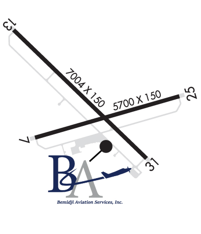
| Lat: N 4730.6 Long: W 09456.1 Elev: 1391 Var: -01 Longest Runway: 7004 | ||
| AWOS: 110.0 CTAF: 122.8 | ||
| ||||||||||||||||||||||||||||||||||||||||||||||||||||||||||||||||||||
| ||||||||||||||||||||||||||||||||||||||||||||||||||||||||||||||||||||
| ||||||||||||||||||||||||||||||||||||||||||||||||||||||||||||||||||||
| Rwy | Rwy | |||||||
| 5700x150 | 5700' | 5700x150 | 5700' | 109.35 - 253° | ||||
| 7004x150 | 7004' | 7004x150 | 7004' | 111.90 - 313° | ||||
| Runway ID | Single Wheel | Double Wheel | Double Tandem Wheel | Dual Double Wheel |
| 07/25 | 86,000 | 150,000 | 269,000 | N/A |
| 13/31 | 75,000 | 200,000 | N/A | N/A |
| These numbers are Advisory and are not limits. The Airport Manager should have more accurate Weight Limits | ||||
 Airport Diagram might not be current. | |
| Facility Name: | BEMIDJI RGNL |
| City Name: | BEMIDJI |
| County: | BELTRAMI |
| State abbrev: | MN |
| State Name: | MINNESOTA |
| Ownership: | PUBLICLY OWNED |
| Use: | OPEN TO THE PUBLIC |
| Owner's Name: | CITY OF BEMIDJI / BELTRAMI CO |
| Address: | 3824 MOBERG DRIVE, STE. 101 |
| BEMIDJI, MN 56601 | |
| Owner's Phone: | 218-444-2438 |
| Manager's Name: | KYLE CHRISTIANSEN; APT MAINT SUPVR, PHONE 218-558-5190. APRT DIRECTOR EMAIL KYLE.CHRISTIANSEN@BEMIDJIAIRPORT.ORG . |
| Address: | 3824 MOBERG DRIVE, STE 101 |
| BEMIDJI, MN 56601 | |
| Phone: | 218-558-5190 |
| FAA Region: | GREAT LAKES |
| FAA Field Office: | DMA |
| Date | Sunrise | Sunset |
|---|---|---|
| 06/08/26 Monday | 5:23 | 21:15 |
| 06/09/26 Tuesday | 5:23 | 21:15 |
| 06/10/26 Wednesday | 5:23 | 21:16 |
| 06/11/26 Thursday | 5:22 | 21:17 |
| 06/12/26 Friday | 5:22 | 21:17 |
| 06/13/26 Saturday | 5:22 | 21:18 |
| 06/14/26 Sunday | 5:22 | 21:18 |
| 06/15/26 Monday | 5:22 | 21:19 |
| 06/16/26 Tuesday | 5:22 | 21:19 |
| 06/17/26 Wednesday | 5:22 | 21:20 |
| 06/18/26 Thursday | 5:22 | 21:20 |
| 06/19/26 Friday | 5:22 | 21:20 |
| 06/20/26 Saturday | 5:22 | 21:20 |
| 06/21/26 Sunday | 5:22 | 21:21 |
| Airport Attendance Schedule | TUE-FRI 0600-2100, SAT-SUN 0800-1700, MON 0700-2100 |
| Airport Status | OPERATIONAL (This Status can change at any time - please check NOTAMS) |
| Airport Lighting Schedule | HIRL RY 13/31 PRESET ON LOW INTST; TO INCR INTST & ACTVT REIL RY 07/25; MIRL RY 07/25; MALSR RY 13/31; HIRL RY 13/31 - CTAF. PAPI RY 07, RY 25, RY 13 AND RY 31 OPR CONTINUOUSLY. |
| Airport Storage Available | Tie Downs, Hanger |
| Extra Services Available | Air Freight, Air Ambulance, Avionics, Cargo Handling, Charter, Flight Instruction, Aircraft Rental |
| Wind Indicator | YES - (lighted) |
| Control Tower | NO |
| CTAF Frequency | 122.800 |
| Unicom Frequency | 122.800 |
| Rotating Beacon Color | WG |
| Segmented Circle | NO |
| Landing Fee | NO |
| Airport Inspected | FEDERAL - performed by STATE AERONAUTICAL PERSONNEL |
| Inspection Date | 08/13/2025 |
| Type of Fuel Available | Grade 100LL, JET A (freeze point -40C) |
| Airframe Repair Service | MAJOR |
| Power Plant Repair Service | MAJOR |
| Latitude | N4730.6 |
| Longitude | W09456.1 (ESTIMATED) |
| Arpt Elevation | 1391ft (SURVEYED) |
| Magnetic Variation | 01E |
| 3 miles NW | of BEMIDJI |
| Traffic Pattern Altitude | |
| Sectional Chart | TWIN CITIES |
| Operations (Reported) | Yearly | Avg. Daily |
|---|---|---|
| General Aviation Transient | 0 | 0 |
| General Aviation Local | 0 | 0 |
| Air Taxi | 0 | 0 |
| Commerical | 0 | 0 |
| Commuter | 0 | 0 |
| Military | 0 | 0 |
| Aircraft based on Field | |
|---|---|
| General Aviation Singles | 0 |
| General Aviation Multi | 0 |
| Jet Aircraft | 0 |
| General Aviation Helicopters | 0 |
| Military Aircraft | 0 |
| Gliders | 0 |
| Ultralights | 0 |
| FSS on field | NO |
| FSS tie-in | PRINCETON |
| FSS Phone | 1-800-WX-BRIEF |
| Who issues Notams | BJI |
| Notam D service at airport | YES |
| ARTCC Name | MINNEAPOLIS |
| Airport Certification | AIRPORT RECEIVING SCHEDULED AIR CARRIER SERVICE FROM CARRIERS CERTIFICATED BY THE CIVIL AERONAUTICS BOARD; 48 HR PPR FOR UNSKED ACR OPNS WITH MORE THAN 30 PSGR SEATS, CALL AMGR 218-444-2438. |
| Aircraft Rescue & Firefighting Index | AIRPORT HAS A CERTIFICATE UNDER CFR PART 139 |
| Airport of Entry | No |
| Custom Landing Rights | No |
| Joint Civil/Military | No |
| Military Landing rights | YES |
| NATIONAL PLAN OF INTEGRATED AIRPORT SYSTEMS (NPIAS) |
| GRANT AGREEMENTS UNDER FAAP/ADAP/AIP |
| ASSURANCES PURSUANT TO TITLE VI, CIVIL RIGHTS ACT OF 1964 |
| AGREEMENT UNDER DLAND OR DCLA HAS EXPIRED. |
| DEER & BIRDS ON & INVOF ARPT. |
| SNOW REMOVAL CREWS MONTR CTAF DURG ALL ACR OPS FOR AIRFIELD COND INFO. |
| ARFF CREWS MONTR CTAF DURG ALL ACR OPS. |
| FOR CD IF UNA TO CTC ON FSS FREQ, CTC MINNEAPOLIS ARTCC AT 651-463-5588. |
| RWY 07/2 5 PCR VALUE: 310/F/A/X/T |
| RWY 13/3 1 PCR VALUE: 380/F/A/X/T |
Airport Communications & Frequencies:
| |||||||||
| Runway: 07 | Runway: 25 | ||
| Mag heading: | 73° | Mag heading: | 253° |
| Rwy Slope: | -.07% Down | Rwy Slope: | .07% Up |
| Approach: | Approach: | ILS/DME | |
| Pattern: | Left Traffic | Pattern: | Left Traffic |
| Markings: | NONPRECISION INSTRUMENT | Markings: | PRECISION INSTRUMENT |
| Marking Condition: | GOOD | Marking Condition: | GOOD |
| Arresting Dev: | Arresting Dev: | ||
| Lat & Long: | N4730.4 W09456.6 | Lat. & Long.: | N4730.7 W09455.3 |
| Elev: | 1383.9 ft. MSL | Elev: | 1379.9 ft. MSL |
| TCH: | 44 ft. AGL | TCH: | 47 ft. AGL |
| Visual Glide Path: | 3.00 degrees | Visual Glide Path: | 3.00 degrees |
| Displaced Threshold: | No | Displaced Threshold: | No |
| Touchdown Zone: | YES | Touchdown Zone: | YES |
| Touchdown Elev.: | 1388.7 feet | Touchdown Elev.: | 1388.7 feet |
| Visual Glide Slope: | 4-Light PAPI on LEFT side of Runway | Visual Glide Slope: | 4-Light PAPI on LEFT side of Runway |
| RVR Equipment: | RVR Equipment: | ||
| RVV Equipment: | NO | RVV Equipment: | NO |
| Approach Lights: | Approach Lights: | ||
| REIL: | YES | REIL: | YES |
| Centerline Lights: | NO | Centerline Lights: | NO |
| Touchdown lights: | NO | Touchdown lights: | NO |
| Runway Category: | Runway with a Visual Approach | Runway Category: | Precision Instrument Runway |
| Declared Distances: | TORA:5700' TODA:5700' ASDA:5700' LDA:5700' | Declared Distances: | TORA:5700' TODA:5700' ASDA:5700' LDA:5700' |
| Obstructions: | Obstructions: | TREES | |
| Marked: | Marked: | NOT Marked/Lighted | |
| Clearance slope: | 20:1 | Clearance slope: | 31:1 |
| Obstruction height: | Obstruction height: | 35 feet AGL | |
| Dist. from runway: | Dist. from runway: | 1294 feet | |
| Centerline offset: | Centerline offset: | 600 feet right of centerline | |
| Comments: | Comments: |
| Runway: 13 | Runway: 31 | ||
| Mag heading: | 133° | Mag heading: | 313° |
| Rwy Slope: | -.10% Down | Rwy Slope: | .10% Up |
| Approach: | Approach: | ILS | |
| Pattern: | Left Traffic | Pattern: | Left Traffic |
| Markings: | PRECISION INSTRUMENT | Markings: | PRECISION INSTRUMENT |
| Marking Condition: | GOOD | Marking Condition: | GOOD |
| Arresting Dev: | Arresting Dev: | ||
| Lat & Long: | N4731.1 W09456.8 | Lat. & Long.: | N4730.3 W09455.6 |
| Elev: | 1391.2 ft. MSL | Elev: | 1384.2 ft. MSL |
| TCH: | 45 ft. AGL | TCH: | 45 ft. AGL |
| Visual Glide Path: | 3.00 degrees | Visual Glide Path: | 3.00 degrees |
| Displaced Threshold: | No | Displaced Threshold: | No |
| Touchdown Zone: | YES | Touchdown Zone: | YES |
| Touchdown Elev.: | 1391.4 feet | Touchdown Elev.: | 1389.2 feet |
| Visual Glide Slope: | 4-Light PAPI on LEFT side of Runway | Visual Glide Slope: | 4-Light PAPI on LEFT side of Runway |
| RVR Equipment: | RVR Equipment: | ||
| RVV Equipment: | NO | RVV Equipment: | NO |
| Approach Lights: | MALSR - 1,400 foot medium intensity approach lighting system with runway alignment indicator lights | Approach Lights: | MALSR - 1,400 foot medium intensity approach lighting system with runway alignment indicator lights |
| REIL: | NO | REIL: | NO |
| Centerline Lights: | NO | Centerline Lights: | NO |
| Touchdown lights: | NO | Touchdown lights: | NO |
| Runway Category: | D | Runway Category: | Precision Instrument Runway |
| Declared Distances: | TORA:7002' TODA:7002' ASDA:7002' LDA:7002' | Declared Distances: | TORA:7002' TODA:7002' ASDA:7002' LDA:7002' |
| Obstructions: | TREES | Obstructions: | |
| Marked: | NOT Marked/Lighted | Marked: | |
| Clearance slope: | 30:1 | Clearance slope: | 50:1 |
| Obstruction height: | 68 feet AGL | Obstruction height: | |
| Dist. from runway: | 2278 feet | Dist. from runway: | |
| Centerline offset: | 362 left of centerline | Centerline offset: | |
| Comments: | Comments: |
Thanks for using FltPlan.com
all rights reserved © 1999-2026 by Flight Plan LLC


