| ROCKY MOUNTAIN METROPOLITAN DENVER CO |
| |
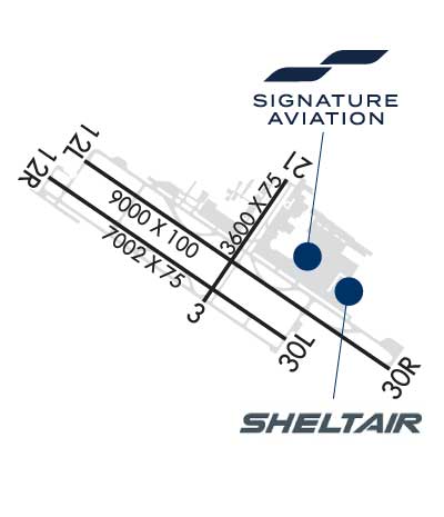
| Lat: N 3954.5 Long: W 10507.0 Elev: 5673 Var: -09 Longest Runway: 9000 | ||
| Clr Del: 132.6 Dept. ATIS: 126.25 Arr. ATIS: 126.25 Ground: 121.7 Tower: 118.6 | ||
| |||||||||||||||||||||||||||||||||||||||||||||||||||||||||||||||||||||
| |||||||||||||||||||||||||||||||||||||||||||||||||||||||||||||||||||||
| |||||||||||||||||||||||||||||||||||||||||||||||||||||||||||||||||||||
| |||||||||||||||||||||||||||||||||||||||||||||||||||||||||||||||||||||
| |||||||||||||||||||||||||||||||||||||||||||||||||||||||||||||||||||||
| |||||||||||||||||||||||||||||||||||||||||||||||||||||||||||||||||||||
| Rwy | Rwy | |||||||
| 3600x75 | 3600' | 3600x75 | 3600' | |||||
| 9000x100 | 9000' | 9000x100 | 9000' | 111.70 - 295° | ||||
| 7002x75 | 7002' | 7002x75 | 7002' | |||||
| Runway ID | Single Wheel | Double Wheel | Double Tandem Wheel | Dual Double Wheel |
| 03/21 | 40,000 | 45,000 | 65,000 | N/A |
| 12L/30R | 65,000 | 105,000 | 150,000 | N/A |
| 12R/30L | 47,000 | 61,000 | N/A | N/A |
| These numbers are Advisory and are not limits. The Airport Manager should have more accurate Weight Limits | ||||
 Airport Diagram might not be current. | |
| Facility Name: | ROCKY MOUNTAIN METRO |
| City Name: | DENVER |
| County: | JEFFERSON |
| State abbrev: | CO |
| State Name: | COLORADO |
| Ownership: | PUBLICLY OWNED |
| Use: | OPEN TO THE PUBLIC |
| Owner's Name: | JEFFERSON COUNTY |
| Address: | 100 JEFFERSON CO PKWY |
| GOLDEN, CO 80419 | |
| Owner's Phone: | (303) 271-4850 |
| Manager's Name: | ERICK DAHL |
| Address: | 11755 AIRPORT WAY |
| BROOMFIELD, CO 80021 | |
| Phone: | (303) 271-4851 |
| FAA Region: | NORTHWEST MOUNTAIN |
| FAA Field Office: | DEN |
| Date | Sunrise | Sunset |
|---|---|---|
| 06/08/26 Monday | 5:32 | 20:27 |
| 06/09/26 Tuesday | 5:32 | 20:28 |
| 06/10/26 Wednesday | 5:32 | 20:28 |
| 06/11/26 Thursday | 5:31 | 20:29 |
| 06/12/26 Friday | 5:31 | 20:29 |
| 06/13/26 Saturday | 5:31 | 20:30 |
| 06/14/26 Sunday | 5:31 | 20:30 |
| 06/15/26 Monday | 5:31 | 20:31 |
| 06/16/26 Tuesday | 5:31 | 20:31 |
| 06/17/26 Wednesday | 5:31 | 20:31 |
| 06/18/26 Thursday | 5:31 | 20:32 |
| 06/19/26 Friday | 5:32 | 20:32 |
| 06/20/26 Saturday | 5:32 | 20:32 |
| 06/21/26 Sunday | 5:32 | 20:32 |
| Airport Attendance Schedule | CONTINUOUS |
| Airport Status | OPERATIONAL (This Status can change at any time - please check NOTAMS) |
| Airport Lighting Schedule | WHEN ATCT CLSD ACTVT MALSR RWY 30R; REIL RWY 12L, 12R & 30L; PAPI RWY 03, 12L, 12R, 21, 30L & 30R; MIRL RWY 03/21 & 12R/30L; HIRL RWY 12L/30R - CTAF. |
| Airport Storage Available | Tie Downs, Hanger |
| Extra Services Available | Air Freight, Avionics, Cargo Handling, Charter, Flight Instruction, Aircraft Rental, Aircraft Sales, Annual Surveying |
| Wind Indicator | YES - (lighted) |
| Control Tower | YES |
| CTAF Frequency | 118.600 |
| Unicom Frequency | |
| Rotating Beacon Color | WG |
| Segmented Circle | YES |
| Landing Fee | NO |
| Airport Inspected | STATE - performed by FAA AIRPORTS FIELD PERSONNEL |
| Inspection Date | 02/26/2026 |
| Type of Fuel Available | Grade 100LL, JET A (freeze point -40C)UL94; -10100LL SELF SVC. |
| Airframe Repair Service | MAJOR |
| Power Plant Repair Service | MAJOR |
| Latitude | N3954.5 |
| Longitude | W10507.0 (ESTIMATED) |
| Arpt Elevation | 5673ft (SURVEYED) |
| Magnetic Variation | 09E |
| 9 miles NW | of DENVER |
| Traffic Pattern Altitude | |
| Sectional Chart | DENVER |
| Operations (Reported) | Yearly | Avg. Daily |
|---|---|---|
| General Aviation Transient | 0 | 0 |
| General Aviation Local | 0 | 0 |
| Air Taxi | 0 | 0 |
| Commerical | 0 | 0 |
| Commuter | 0 | 0 |
| Military | 0 | 0 |
| Aircraft based on Field | |
|---|---|
| General Aviation Singles | 0 |
| General Aviation Multi | 0 |
| Jet Aircraft | 0 |
| General Aviation Helicopters | 0 |
| Military Aircraft | 0 |
| Gliders | 0 |
| Ultralights | 0 |
| FSS on field | NO |
| FSS tie-in | DENVER |
| FSS Phone | 1-800-WX-BRIEF |
| Who issues Notams | BJC |
| Notam D service at airport | YES |
| ARTCC Name | DENVER |
| Airport Certification | AIRPORT RECEIVING SCHEDULED AIR CARRIER SERVICE FROM CARRIERS CERTIFICATED BY THE CIVIL AERONAUTICS BOARD; 24 HR PPR FOR UNSKED ACR OPS WITH MORE THAN 30 PAX SEATS - 720-352-0395. |
| Aircraft Rescue & Firefighting Index | AIRPORT HAS A CERTIFICATE UNDER CFR PART 139 |
| Airport of Entry | No |
| Custom Landing Rights | No; US CUSTOMS USER FEE ARPT. |
| Joint Civil/Military | No |
| Military Landing rights | No |
| NATIONAL PLAN OF INTEGRATED AIRPORT SYSTEMS (NPIAS) |
| GRANT AGREEMENTS UNDER FAAP/ADAP/AIP |
| ASSURANCES PURSUANT TO TITLE VI, CIVIL RIGHTS ACT OF 1964 |
| THIS AIRPORT HAS BEEN SURVEYED BY THE NATIONAL GEODETIC SURVEY. |
| BIRDS & WILDLIFE ON & INVOF RWY. |
| TWY C1 & D MKD WITH REFLECTORS. |
| N TRML RAMP SLP EXCEEDS RCMDD STD. |
| HEL ARR/DEP FM RWY & TWYS. |
| ARFF INDEX B AVBL PPR - 720-352-0395 |
| PILOTS ARE REQUESTED TO AVOID FLIGHT DUE TO NESTING EAGLES: BLW 6500 FT MSL, BJC VOR 25 DEG RADIAL, 2.7 DME; OVER STANDLEY LAKE BLW 8000 FT MSL, BJC VOR 150 DEG RADIAL, 3.0 DME. |
| NOISE ABATEMENT PROC IN EFCT - 303-271-4850. |
| FLIGHT NOTIFICATION SERVICE (ADCUS) AVBL. |
| RWY 03/2 1 PCR VALUE: 130/F/D/X/T |
| RWY 12L/ 30RPCR VALUE: 360/F/D/X/T |
| RWY 12R/ 30LPCR VALUE: 150/F/C/X/T |
Airport Communications & Frequencies:
| |||||||||||||||||||||||||||
| Runway: 03 | Runway: 21 | ||
| Mag heading: | 25° | Mag heading: | 205° |
| Rwy Slope: | -.44% Down | Rwy Slope: | .44% Up |
| Approach: | Approach: | ||
| Pattern: | Left Traffic | Pattern: | Right Traffic |
| Markings: | BASIC | Markings: | BASIC |
| Marking Condition: | FAIR | Marking Condition: | FAIR |
| Arresting Dev: | Arresting Dev: | ||
| Lat & Long: | N3954.4 W10507.1 | Lat. & Long.: | N3954.8 W10506.7 |
| Elev: | 5616.0 ft. MSL | Elev: | 5600.0 ft. MSL |
| TCH: | 30 ft. AGL | TCH: | 40 ft. AGL |
| Visual Glide Path: | 3.00 degrees | Visual Glide Path: | 3.00 degrees |
| Displaced Threshold: | No | Displaced Threshold: | No |
| Touchdown Zone: | YES | Touchdown Zone: | YES |
| Touchdown Elev.: | 5620.4 feet | Touchdown Elev.: | 5620.4 feet |
| Visual Glide Slope: | 2-Light PAPI on LEFT side of Runway | Visual Glide Slope: | 2-Light PAPI on LEFT side of Runway |
| RVR Equipment: | RVR Equipment: | ||
| RVV Equipment: | NO | RVV Equipment: | NO |
| Approach Lights: | Approach Lights: | ||
| REIL: | NO | REIL: | NO |
| Centerline Lights: | NO | Centerline Lights: | NO |
| Touchdown lights: | NO | Touchdown lights: | NO |
| Runway Category: | Runway with a Visual Approach | Runway Category: | Runway with a Visual Approach |
| Declared Distances: | TORA:3600' TODA:3600' ASDA:3600' LDA:3600' | Declared Distances: | TORA:3600' TODA:3600' ASDA:3600' LDA:3600' |
| Runway: 12L | Runway: 30R | ||
| Mag heading: | 115° | Mag heading: | 295° |
| Rwy Slope: | -1.05% Down | Rwy Slope: | 1.05% Up |
| Approach: | Approach: | ILS | |
| Pattern: | Left Traffic | Pattern: | Right Traffic |
| Markings: | PRECISION INSTRUMENT | Markings: | PRECISION INSTRUMENT |
| Marking Condition: | FAIR | Marking Condition: | FAIR |
| Arresting Dev: | Arresting Dev: | ||
| Lat & Long: | N3954.9 W10507.7 | Lat. & Long.: | N3954.1 W10506.1 |
| Elev: | 5660.5 ft. MSL | Elev: | 5565.9 ft. MSL |
| TCH: | 41 ft. AGL | TCH: | 52 ft. AGL |
| Visual Glide Path: | 3.00 degrees | Visual Glide Path: | 3.00 degrees |
| Displaced Threshold: | No | Displaced Threshold: | No |
| Touchdown Zone: | YES | Touchdown Zone: | YES |
| Touchdown Elev.: | 5660.6 feet | Touchdown Elev.: | 5598.5 feet |
| Visual Glide Slope: | 4-Light PAPI on LEFT side of Runway | Visual Glide Slope: | 4-Light PAPI on LEFT side of Runway |
| RVR Equipment: | RVR Equipment: | ||
| RVV Equipment: | NO | RVV Equipment: | NO |
| Approach Lights: | Approach Lights: | MALSR - 1,400 foot medium intensity approach lighting system with runway alignment indicator lights | |
| REIL: | YES | REIL: | NO |
| Centerline Lights: | NO | Centerline Lights: | NO |
| Touchdown lights: | NO | Touchdown lights: | NO |
| Runway Category: | Runway with a Visual Approach | Runway Category: | Precision Instrument Runway |
| Declared Distances: | TORA:9000' TODA:9000' ASDA:9000' LDA:9000' | Declared Distances: | TORA:9000' TODA:9000' ASDA:9000' LDA:9000' |
| Runway: 12R | Runway: 30L | ||
| Mag heading: | 115° | Mag heading: | 295° |
| Rwy Slope: | -1.11% Down | Rwy Slope: | 1.11% Up |
| Approach: | Approach: | ||
| Pattern: | Right Traffic | Pattern: | Left Traffic |
| Markings: | NONPRECISION INSTRUMENT | Markings: | NONPRECISION INSTRUMENT |
| Marking Condition: | FAIR | Marking Condition: | FAIR |
| Arresting Dev: | Arresting Dev: | ||
| Lat & Long: | N3954.9 W10507.9 | Lat. & Long.: | N3954.2 W10506.7 |
| Elev: | 5673.3 ft. MSL | Elev: | 5595.4 ft. MSL |
| TCH: | 40 ft. AGL | TCH: | 41 ft. AGL |
| Visual Glide Path: | 3.00 degrees | Visual Glide Path: | 3.00 degrees |
| Displaced Threshold: | No | Displaced Threshold: | No |
| Touchdown Zone: | YES | Touchdown Zone: | YES |
| Touchdown Elev.: | 5673.4 feet | Touchdown Elev.: | 5628.4 feet |
| Visual Glide Slope: | 2-Light PAPI on LEFT side of Runway | Visual Glide Slope: | 2-Light PAPI on LEFT side of Runway |
| RVR Equipment: | RVR Equipment: | ||
| RVV Equipment: | NO | RVV Equipment: | NO |
| Approach Lights: | Approach Lights: | ||
| REIL: | YES | REIL: | YES |
| Centerline Lights: | NO | Centerline Lights: | NO |
| Touchdown lights: | NO | Touchdown lights: | NO |
| Runway Category: | Runway with a Visual Approach | Runway Category: | Runway with a Non-precision Approach having visibility minimums greater than 3/4 mile |
| Declared Distances: | TORA:7002' TODA:7002' ASDA:7002' LDA:7002' | Declared Distances: | TORA:7002' TODA:7002' ASDA:7002' LDA:7002' |
Thanks for using FltPlan.com
all rights reserved © 1999-2026 by Flight Plan LLC