| BISMARCK MUNI BISMARCK ND |
| |
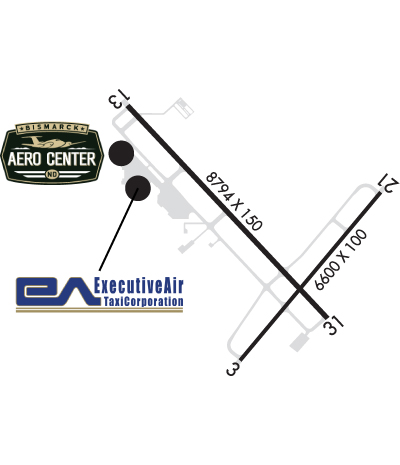
| Lat: N 4646.4 Long: W 10044.7 Elev: 1661 Var: -07 Longest Runway: 8794 | ||
| Dept. ATIS: 119.35 Arr. ATIS: 119.35 AWOS: 119.35 Ground: 121.9 Tower: 118.3 | ||
| ||||||||||||||||||||||||||||||||||||||||||||
| ||||||||||||||||||||||||||||||||||||||||||||
| ||||||||||||||||||||||||||||||||||||||||||||
| ||||||||||||||||||||||||||||||||||||||||||||
| FBOs at nearby airports who want your business: | |||||||||||||||||
| |||||||||||||||||
| Rwy | Rwy | |||||||
| 6600x100 | 6600' | 6600x100 | 6600' | |||||
| 8794x150 | 8794' | 111.50 - 130° | 8794x150 | 8794' | 110.30 - 310° | |||
| Runway ID | Single Wheel | Double Wheel | Double Tandem Wheel | Dual Double Wheel |
| 03/21 | 104,000 | 140,000 | 198,000 | N/A |
| 13/31 | 120,000 | 225,000 | 342,000 | N/A |
| These numbers are Advisory and are not limits. The Airport Manager should have more accurate Weight Limits | ||||
 Airport Diagram might not be current. | |
| Facility Name: | BISMARCK MUNI |
| City Name: | BISMARCK |
| County: | BURLEIGH |
| State abbrev: | ND |
| State Name: | NORTH DAKOTA |
| Ownership: | PUBLICLY OWNED |
| Use: | OPEN TO THE PUBLIC |
| Owner's Name: | CITY OF BISMARCK |
| Address: | BOX 991 |
| BISMARCK, ND 58502 | |
| Owner's Phone: | 701-355-1808 |
| Manager's Name: | GREGORY B HAUG; 24HR CONTACT: OPERATIONS 701-220-9885. |
| Address: | BOX 991 |
| BISMARCK, ND 58502-0991 | |
| Phone: | 701-355-1808 |
| FAA Region: | GREAT LAKES |
| FAA Field Office: | DMA |
| Date | Sunrise | Sunset |
|---|---|---|
| 06/12/26 Friday | 5:49 | 21:37 |
| 06/13/26 Saturday | 5:48 | 21:38 |
| 06/14/26 Sunday | 5:48 | 21:38 |
| 06/15/26 Monday | 5:48 | 21:39 |
| 06/16/26 Tuesday | 5:48 | 21:39 |
| 06/17/26 Wednesday | 5:48 | 21:40 |
| 06/18/26 Thursday | 5:48 | 21:40 |
| 06/19/26 Friday | 5:48 | 21:40 |
| 06/20/26 Saturday | 5:49 | 21:40 |
| 06/21/26 Sunday | 5:49 | 21:41 |
| 06/22/26 Monday | 5:49 | 21:41 |
| 06/23/26 Tuesday | 5:49 | 21:41 |
| 06/24/26 Wednesday | 5:50 | 21:41 |
| 06/25/26 Thursday | 5:50 | 21:41 |
| Airport Attendance Schedule | CONTINUOUS |
| Airport Status | OPERATIONAL (This Status can change at any time - please check NOTAMS) |
| Airport Lighting Schedule | WHEN ATCT CLSD HIRL RYS 13/31 & 03/21 PRESET MED INTST; PAPI RYS 13; 31; 03; & 21 ON; ACTVT MALS RY 13 & MALSR RY 31 - CTAF. |
| Airport Storage Available | Tie Downs, Hanger |
| Extra Services Available | Air Freight, Air Ambulance, Avionics, Charter, Flight Instruction, Aircraft Rental, Aircraft Sales |
| Wind Indicator | YES - (lighted) |
| Control Tower | YES |
| CTAF Frequency | 118.300 |
| Unicom Frequency | 122.950 |
| Rotating Beacon Color | WG |
| Segmented Circle | NO |
| Landing Fee | NO |
| Airport Inspected | FEDERAL - performed by FAA AIRPORTS FIELD PERSONNEL |
| Inspection Date | 09/18/2025 |
| Type of Fuel Available | Grade 100LL, JET A (freeze point -40C); -10FOR FUEL CALL 701-223-4754 OR 701-258-5024. |
| Airframe Repair Service | MAJOR |
| Power Plant Repair Service | MAJOR |
| Latitude | N4646.4 |
| Longitude | W10044.7 (ESTIMATED) |
| Arpt Elevation | 1661ft (SURVEYED) |
| Magnetic Variation | 07E |
| 3 miles SE | of BISMARCK |
| Traffic Pattern Altitude | |
| Sectional Chart | TWIN CITIES |
| Operations (Reported) | Yearly | Avg. Daily |
|---|---|---|
| General Aviation Transient | 0 | 0 |
| General Aviation Local | 0 | 0 |
| Air Taxi | 0 | 0 |
| Commerical | 0 | 0 |
| Commuter | 0 | 0 |
| Military | 0 | 0 |
| Aircraft based on Field | |
|---|---|
| General Aviation Singles | 0 |
| General Aviation Multi | 0 |
| Jet Aircraft | 0 |
| General Aviation Helicopters | 0 |
| Military Aircraft | 0 |
| Gliders | 0 |
| Ultralights | 0 |
| FSS on field | NO |
| FSS tie-in | GRAND FORKS |
| FSS Phone | 1-800-WX-BRIEF |
| Who issues Notams | BIS |
| Notam D service at airport | YES |
| ARTCC Name | MINNEAPOLIS |
| Airport Certification | AIRPORT RECEIVING SCHEDULED AIR CARRIER SERVICE FROM CARRIERS CERTIFICATED BY THE CIVIL AERONAUTICS BOARD |
| Aircraft Rescue & Firefighting Index | AIRPORT HAS A CERTIFICATE UNDER CFR PART 139 |
| Airport of Entry | No |
| Custom Landing Rights | No |
| Joint Civil/Military | No |
| Military Landing rights | YES |
| NATIONAL PLAN OF INTEGRATED AIRPORT SYSTEMS (NPIAS) |
| GRANT AGREEMENTS UNDER FAAP/ADAP/AIP |
| SURPLUS PROPERTY AGREEMENT UNDER PUBLIC LAW 289 |
| CONVEYANCE UNDER SCETION 16, FEDERAL AIRPORT ACT OF 1946 OR SECTION 23, AIRPORT AND AIRWAY DEVELOPMENT ACT OF 1970 |
| ASSURANCES PURSUANT TO TITLE VI, CIVIL RIGHTS ACT OF 1964 |
| AGREEMENT UNDER DLAND OR DCLA HAS EXPIRED. |
| DEER, COYOTES & BIRDS ON & INVOF ARPT. |
| FOR CD IF UNA TO CTC ON FSS FREQ, CTC MINNEAPOLIS ARTCC AT 651-463-5588. |
| RWY 213 0Z++ MON-FRI EXC HOL, PPR 24 PN RQR DSN 373-4071/70, C701-3334071/70. FW PAX TRML LCTD IN 'SE' HGR. |
| RWY 03 RESA NSTD. |
| RWY 21 RESA NSTD. |
| RWY 03/2 1 PCR VALUE: 430/F/D/X/T |
| RWY 13/3 1 PCR VALUE: 750/R/D/W/T |
Airport Communications & Frequencies:
| |||||||||||||||||||||||||||||
| Runway: 03 | Runway: 21 | ||
| Mag heading: | 32° | Mag heading: | 212° |
| Rwy Slope: | .01% Up | Rwy Slope: | -.01% Down |
| Approach: | Approach: | ||
| Pattern: | Left Traffic | Pattern: | Left Traffic |
| Markings: | PRECISION INSTRUMENT | Markings: | PRECISION INSTRUMENT |
| Marking Condition: | GOOD | Marking Condition: | GOOD |
| Arresting Dev: | Arresting Dev: | ||
| Lat & Long: | N4645.8 W10044.9 | Lat. & Long.: | N4646.6 W10043.9 |
| Elev: | 1660.6 ft. MSL | Elev: | 1661.3 ft. MSL |
| TCH: | 48 ft. AGL | TCH: | 48 ft. AGL |
| Visual Glide Path: | 3.00 degrees | Visual Glide Path: | 3.00 degrees |
| Displaced Threshold: | No | Displaced Threshold: | No |
| Touchdown Zone: | YES | Touchdown Zone: | YES |
| Touchdown Elev.: | 1660.6 feet | Touchdown Elev.: | 1661.3 feet |
| Visual Glide Slope: | 4-Light PAPI on LEFT side of Runway | Visual Glide Slope: | 4-Light PAPI on LEFT side of Runway |
| RVR Equipment: | RVR Equipment: | ||
| RVV Equipment: | NO | RVV Equipment: | NO |
| Approach Lights: | Approach Lights: | ||
| REIL: | YES | REIL: | YES |
| Centerline Lights: | NO | Centerline Lights: | NO |
| Touchdown lights: | NO | Touchdown lights: | NO |
| Runway Category: | D | Runway Category: | D |
| Declared Distances: | TORA:6600' TODA:6600' ASDA:6600' LDA:6600' | Declared Distances: | TORA:6600' TODA:6600' ASDA:6600' LDA:6600' |
| Runway: 13 | Runway: 31 | ||
| Mag heading: | 131° | Mag heading: | 311° |
| Rwy Slope: | -.11% Down | Rwy Slope: | .11% Up |
| Approach: | ILS | Approach: | ILS/DME |
| Pattern: | Left Traffic | Pattern: | Left Traffic |
| Markings: | PRECISION INSTRUMENT | Markings: | PRECISION INSTRUMENT |
| Marking Condition: | GOOD | Marking Condition: | GOOD |
| Arresting Dev: | Arresting Dev: | ||
| Lat & Long: | N4647.0 W10045.7 | Lat. & Long.: | N4646.0 W10044.3 |
| Elev: | 1654.6 ft. MSL | Elev: | 1645.2 ft. MSL |
| TCH: | 58 ft. AGL | TCH: | 48 ft. AGL |
| Visual Glide Path: | 3.00 degrees | Visual Glide Path: | 3.00 degrees |
| Displaced Threshold: | No | Displaced Threshold: | No |
| Touchdown Zone: | YES | Touchdown Zone: | YES |
| Touchdown Elev.: | 1654.6 feet | Touchdown Elev.: | 1645.7 feet |
| Visual Glide Slope: | 4-Light PAPI on LEFT side of Runway | Visual Glide Slope: | 4-Light PAPI on LEFT side of Runway |
| RVR Equipment: | ROLLOUT | RVR Equipment: | TOUCHDOWN |
| RVV Equipment: | NO | RVV Equipment: | NO |
| Approach Lights: | MALS - 1,400 foot medium intensity approach lighting system | Approach Lights: | MALSR - 1,400 foot medium intensity approach lighting system with runway alignment indicator lights |
| REIL: | NO | REIL: | NO |
| Centerline Lights: | NO | Centerline Lights: | NO |
| Touchdown lights: | NO | Touchdown lights: | NO |
| Runway Category: | Precision Instrument Runway | Runway Category: | Precision Instrument Runway |
| Declared Distances: | TORA:8794' TODA:8794' ASDA:8794' LDA:8794' | Declared Distances: | TORA:8794' TODA:8794' ASDA:8794' LDA:8794' |
| Obstructions: | POLE | Obstructions: | |
| Marked: | LIGHTED | Marked: | |
| Clearance slope: | 34:1 | Clearance slope: | 50:1 |
| Obstruction height: | 43 feet AGL | Obstruction height: | |
| Dist. from runway: | 1662 feet | Dist. from runway: | |
| Centerline offset: | 688 left of centerline | Centerline offset: | |
| Comments: | Comments: |
Thanks for using FltPlan.com
all rights reserved © 1999-2026 by Flight Plan LLC