
| VIRGIL I GRISSOM MUNI BEDFORD IN |
| |
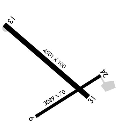
| Lat: N 3850.4 Long: W 08626.7 Elev: 727 Var: +04 Longest Runway: 4501 | ||
| AWOS: 119.12 CTAF: 122.8 | ||
| ||||||||||||||||||||||||||||||||||||||||||||
| ||||||||||||||||||||||||||||||||||||||||||||
| ||||||||||||||||||||||||||||||||||||||||||||
| Rwy | Rwy | |||||||
| 3089x70 | 3089' | 3089x70 | 3089' | |||||
| 4501x100 | 4501' | 4501x100 | 4501' | |||||
| Runway ID | Single Wheel | Double Wheel | Double Tandem Wheel | Dual Double Wheel |
| 06/24 | 4,000 | N/A | N/A | N/A |
| 13/31 | 25,000 | 30,000 | N/A | N/A |
| These numbers are Advisory and are not limits. The Airport Manager should have more accurate Weight Limits | ||||
 Airport Diagram might not be current. | |
| Facility Name: | VIRGIL I GRISSOM MUNI |
| City Name: | BEDFORD |
| County: | LAWRENCE |
| State abbrev: | IN |
| State Name: | INDIANA |
| Ownership: | PUBLICLY OWNED |
| Use: | OPEN TO THE PUBLIC |
| Owner's Name: | LAWRENCE COUNTY BOAC |
| Address: | 3213 TUNNELTON RD. |
| BEDFORD, IN 47421 | |
| Owner's Phone: | 812-279-9839 |
| Manager's Name: | |
| Address: | |
| Phone: | |
| FAA Region: | GREAT LAKES |
| FAA Field Office: | CHI |
| Date | Sunrise | Sunset |
|---|---|---|
| 09/24/21 Friday | 7:35 | 19:40 |
| 09/25/21 Saturday | 7:36 | 19:38 |
| 09/26/21 Sunday | 7:37 | 19:37 |
| 09/27/21 Monday | 7:38 | 19:35 |
| 09/28/21 Tuesday | 7:39 | 19:34 |
| 09/29/21 Wednesday | 7:40 | 19:32 |
| 09/30/21 Thursday | 7:41 | 19:30 |
| 10/01/21 Friday | 7:41 | 19:29 |
| 10/02/21 Saturday | 7:42 | 19:27 |
| 10/03/21 Sunday | 7:43 | 19:26 |
| 10/04/21 Monday | 7:44 | 19:24 |
| 10/05/21 Tuesday | 7:45 | 19:23 |
| 10/06/21 Wednesday | 7:46 | 19:21 |
| 10/07/21 Thursday | 7:47 | 19:20 |
| Airport Attendance Schedule | MON-FRI 0900-1700, SAT 0900-1200; ARPT CLSD NEW YEARS, THANKSGIVING & CHRISTMAS DAY. |
| Airport Status | OPERATIONAL (This Status can change at any time - please check NOTAMS) |
| Airport Lighting Schedule | ACTVT REIL RWY 13 & 31; MIRL RWY 06/24 & 13/31 - CTAF. MIRL RWY 06/24 & 13/31 PRESET LOW INTST; INCR INTST - CTAF. |
| Airport Storage Available | Tie Downs, Hanger |
| Extra Services Available | Flight Instruction, Aircraft Rental |
| Wind Indicator | YES - (lighted) |
| Control Tower | NO |
| CTAF Frequency | 122.800 |
| Unicom Frequency | 122.800 |
| Rotating Beacon Color | CLEAR-GREEN (Light Land Airport) |
| Segmented Circle | NO |
| Landing Fee | NO |
| Airport Inspected | STATE - performed by STATE AERONAUTICAL PERSONNEL |
| Inspection Date | 05/01/2020 |
| Type of Fuel Available | Grade 100LL, JET A (freeze point -40C) |
| Airframe Repair Service | MAJOR |
| Power Plant Repair Service | MAJOR |
| Latitude | N3850.4 |
| Longitude | W08626.7 (ESTIMATED) |
| Arpt Elevation | 727ft (SURVEYED) |
| Magnetic Variation | 04W |
| 3 miles SE | of BEDFORD |
| Traffic Pattern Altitude | 800 |
| Sectional Chart | ST LOUIS |
| Operations (Reported) | Yearly | Avg. Daily |
|---|---|---|
| General Aviation Transient | 2667 | 7 |
| General Aviation Local | 2667 | 7 |
| Air Taxi | 312 | 1 |
| Commerical | 0 | 0 |
| Commuter | 0 | 0 |
| Military | 212 | 1 |
| Aircraft based on Field | |
|---|---|
| General Aviation Singles | 24 |
| General Aviation Multi | 1 |
| Jet Aircraft | 0 |
| General Aviation Helicopters | 1 |
| Military Aircraft | 0 |
| Gliders | 0 |
| Ultralights | 3 |
| FSS on field | NO |
| FSS tie-in | TERRE HAUTE |
| FSS Phone | 1-800-WX-BRIEF |
| Who issues Notams | HUF |
| Notam D service at airport | YES |
| ARTCC Name | INDIANAPOLIS |
| Airport Certification | |
| Aircraft Rescue & Firefighting Index | None |
| Airport of Entry | No |
| Custom Landing Rights | No |
| Joint Civil/Military | No |
| Military Landing rights | YES |
| NATIONAL PLAN OF INTEGRATED AIRPORT SYSTEMS (NPIAS) |
| GRANT AGREEMENTS UNDER FAAP/ADAP/AIP |
| ASSURANCES PURSUANT TO TITLE VI, CIVIL RIGHTS ACT OF 1964 |
| LINE OF SIGHT RSTRNS TO VIS. |
| DEER ON & INVOF ARPT. |
| FOR CD CTC INDIANAPOLIS ARTCC AT 317-247-2411. |
| RWY 13/3 1 BRUSH & TREES 200 FT L & R OF CNTRLN ENTIRE LENGTH OF RWY. |
Airport Communications & Frequencies:
| |||||||||
| Runway: 06 | Runway: 24 | ||
| Mag heading: | 62° | Mag heading: | 242° |
| Rwy Slope: | .32% Up | Rwy Slope: | -.32% Down |
| Approach: | Approach: | ||
| Pattern: | Left Traffic | Pattern: | Left Traffic |
| Markings: | BASIC | Markings: | BASIC |
| Marking Condition: | FAIR | Marking Condition: | FAIR |
| Arresting Dev: | Arresting Dev: | ||
| Lat & Long: | N3850.1 W08626.9 | Lat. & Long.: | N3850.4 W08626.3 |
| Elev: | 712.7 ft. MSL | Elev: | 722.5 ft. MSL |
| TCH: | TCH: | ||
| Visual Glide Path: | Visual Glide Path: | ||
| Displaced Threshold: | No | Displaced Threshold: | No |
| Touchdown Zone: | YES | Touchdown Zone: | YES |
| Touchdown Elev.: | 727.4 feet | Touchdown Elev.: | 727.4 feet |
| Visual Glide Slope: | Visual Glide Slope: | ||
| RVR Equipment: | RVR Equipment: | ||
| RVV Equipment: | NO | RVV Equipment: | NO |
| Approach Lights: | Approach Lights: | ||
| REIL: | NO | REIL: | NO |
| Centerline Lights: | NO | Centerline Lights: | NO |
| Touchdown lights: | NO | Touchdown lights: | NO |
| Runway Category: | Runway with a Visual Approach | Runway Category: | Runway with a Visual Approach |
| Declared Distances: | Declared Distances: | ||
| Obstructions: | TREES | Obstructions: | BRUSH |
| Marked: | NOT Marked/Lighted | Marked: | NOT Marked/Lighted |
| Clearance slope: | 17:1; APCH SLOPE 26:1 AT THR. | Clearance slope: | APCH SLOPE 22:1 AT THR. |
| Obstruction height: | 24 feet AGL | Obstruction height: | 15 feet AGL |
| Dist. from runway: | 629 feet | Dist. from runway: | 201 feet |
| Centerline offset: | 65 right of centerline | Centerline offset: | 100 feet right of centerline |
| Comments: | Comments: | 10 FT DOWNSLOPE TERRAIN & BRUSH 175-200 FT FM RWY END. |
| Runway: 13 | Runway: 31 | ||
| Mag heading: | 133° | Mag heading: | 313° |
| Rwy Slope: | .26% Up | Rwy Slope: | -.26% Down |
| Approach: | Approach: | ||
| Pattern: | Left Traffic | Pattern: | Left Traffic |
| Markings: | NONPRECISION INSTRUMENT | Markings: | NONPRECISION INSTRUMENT |
| Marking Condition: | GOOD | Marking Condition: | GOOD |
| Arresting Dev: | Arresting Dev: | ||
| Lat & Long: | N3850.7 W08627.2 | Lat. & Long.: | N3850.3 W08626.4 |
| Elev: | 711.8 ft. MSL | Elev: | 723.3 ft. MSL |
| TCH: | TCH: | 44 ft. AGL | |
| Visual Glide Path: | Visual Glide Path: | 3.50 degrees | |
| Displaced Threshold: | No | Displaced Threshold: | No |
| Touchdown Zone: | YES | Touchdown Zone: | YES |
| Touchdown Elev.: | 720.9 feet | Touchdown Elev.: | 724.7 feet |
| Visual Glide Slope: | Visual Glide Slope: | 2-Light PAPI on LEFT side of Runway | |
| RVR Equipment: | RVR Equipment: | ||
| RVV Equipment: | NO | RVV Equipment: | NO |
| Approach Lights: | Approach Lights: | ||
| REIL: | YES | REIL: | YES |
| Centerline Lights: | NO | Centerline Lights: | NO |
| Touchdown lights: | NO | Touchdown lights: | NO |
| Runway Category: | Runway with a Non-precision Approach having visibility minimums greater than 3/4 mile | Runway Category: | Runway with a Non-precision Approach having visibility minimums greater than 3/4 mile |
| Declared Distances: | Declared Distances: | ||
| Obstructions: | TREES | Obstructions: | TREE |
| Marked: | NOT Marked/Lighted | Marked: | NOT Marked/Lighted |
| Clearance slope: | Clearance slope: | 19:1 | |
| Obstruction height: | 47 feet AGL | Obstruction height: | 90 feet AGL |
| Dist. from runway: | 200 feet | Dist. from runway: | 1950 feet |
| Centerline offset: | 190 right of centerline | Centerline offset: | 280 feet left of centerline |
| Comments: | 47 FT TREE LINE 0-200 FT FM RWY END 190 FT R OF CNTRLN. | Comments: |
Thanks for using FltPlan.com
all rights reserved © 1999-2021 by Flight Plan LLC
