
| MOBILE DOWNTOWN MOBILE AL |
| |
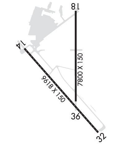
| Lat: N 3037.6 Long: W 08804.1 Elev: 26 Var: +01 Longest Runway: 9618 | ||
| Dept. ATIS: 135.57 Arr. ATIS: 135.57 AWOS: 135.57 Ground: 121.7 Tower: 118.8 | ||
| ||||||||||||||||||||||||||||||||||||||||||||
| ||||||||||||||||||||||||||||||||||||||||||||
| ||||||||||||||||||||||||||||||||||||||||||||
| Rwy | Rwy | |||||||
| 9618x150 | 9618' | 9618x150 | 9618' | 108.50 - 319° | ||||
| 7800x150 | 7800' | 7800x150 | 7800' | |||||
| Runway ID | Single Wheel | Double Wheel | Double Tandem Wheel | Dual Double Wheel |
| 14/32 | 75,000 | 185,000 | 325,000 | N/A |
| 18/36 | 76,000 | 150,000 | 320,000 | N/A |
| These numbers are Advisory and are not limits. The Airport Manager should have more accurate Weight Limits | ||||
 Airport Diagram might not be current. | |
| Facility Name: | MOBILE DOWNTOWN |
| City Name: | MOBILE |
| County: | MOBILE |
| State abbrev: | AL |
| State Name: | ALABAMA |
| Ownership: | PUBLICLY OWNED |
| Use: | OPEN TO THE PUBLIC |
| Owner's Name: | MOBILE AIRPORT AUTHORITY |
| Address: | 1891-9TH ST/BROOKLEY COMPLEX |
| MOBILE, AL 36615 | |
| Owner's Phone: | 251-438-7334 |
| Manager's Name: | CHRIS CURRY |
| Address: | P O BOX 88004 |
| MOBILE, AL 36608 | |
| Phone: | 251-639-4680; FAX PHONE 251-694-7667. |
| FAA Region: | SOUTHERN |
| FAA Field Office: | JAN |
| Date | Sunrise | Sunset |
|---|---|---|
| 09/24/21 Friday | 6:42 | 18:47 |
| 09/25/21 Saturday | 6:42 | 18:45 |
| 09/26/21 Sunday | 6:43 | 18:44 |
| 09/27/21 Monday | 6:43 | 18:43 |
| 09/28/21 Tuesday | 6:44 | 18:42 |
| 09/29/21 Wednesday | 6:44 | 18:40 |
| 09/30/21 Thursday | 6:45 | 18:39 |
| 10/01/21 Friday | 6:46 | 18:38 |
| 10/02/21 Saturday | 6:46 | 18:37 |
| 10/03/21 Sunday | 6:47 | 18:35 |
| 10/04/21 Monday | 6:47 | 18:34 |
| 10/05/21 Tuesday | 6:48 | 18:33 |
| 10/06/21 Wednesday | 6:49 | 18:32 |
| 10/07/21 Thursday | 6:49 | 18:30 |
| Airport Attendance Schedule | 7 Days A Week 0700-2300 |
| Airport Status | OPERATIONAL (This Status can change at any time - please check NOTAMS) |
| Airport Lighting Schedule | DUSK-DAWN. WHEN ATCT CLSD ACTVT MALSR RWY 32 - CTAF. HIRL RWY 14/32 PRESET ON STEP 3 OR HYR BASED ON WX. |
| Airport Storage Available | Tie Downs, Hanger |
| Extra Services Available | Cargo Handling, Charter, Flight Instruction, Aircraft Rental, Aircraft Sales |
| Wind Indicator | YES - (lighted) |
| Control Tower | YES |
| CTAF Frequency | 118.800 |
| Unicom Frequency | 122.950 |
| Rotating Beacon Color | CLEAR-GREEN (Light Land Airport) |
| Segmented Circle | YES |
| Landing Fee | NO |
| Airport Inspected | FEDERAL - performed by FAA AIRPORTS FIELD PERSONNEL |
| Inspection Date | 11/20/2019 |
| Type of Fuel Available | Grade 100LL, JET A (freeze point -40C) |
| Airframe Repair Service | MAJOR |
| Power Plant Repair Service | MAJOR |
| Latitude | N3037.6 |
| Longitude | W08804.1 (ESTIMATED) |
| Arpt Elevation | 26ft (SURVEYED) |
| Magnetic Variation | 01W |
| 3 miles S | of MOBILE |
| Traffic Pattern Altitude | |
| Sectional Chart | NEW ORLEANS |
| Operations (Reported) | Yearly | Avg. Daily |
|---|---|---|
| General Aviation Transient | 9093 | 25 |
| General Aviation Local | 2911 | 8 |
| Air Taxi | 160725 | 440 |
| Commerical | 2065 | 6 |
| Commuter | 0 | 0 |
| Military | 258622 | 709 |
| Aircraft based on Field | |
|---|---|
| General Aviation Singles | 16 |
| General Aviation Multi | 3 |
| Jet Aircraft | 6 |
| General Aviation Helicopters | 1 |
| Military Aircraft | 0 |
| Gliders | 0 |
| Ultralights | 0 |
| FSS on field | NO |
| FSS tie-in | ANNISTON |
| FSS Phone | 1-800-WX-BRIEF |
| Who issues Notams | BFM |
| Notam D service at airport | YES |
| ARTCC Name | HOUSTON |
| Airport Certification | AIRPORT RECEIVING SCHEDULED AIR CARRIER SERVICE FROM CARRIERS CERTIFICATED BY THE CIVIL AERONAUTICS BOARD |
| Aircraft Rescue & Firefighting Index | AIRPORT HAS A CERTIFICATE UNDER CFR PART 139 |
| Airport of Entry | No |
| Custom Landing Rights | YES |
| Joint Civil/Military | No |
| Military Landing rights | YES |
| NATIONAL PLAN OF INTEGRATED AIRPORT SYSTEMS (NPIAS) |
| GRANT AGREEMENTS UNDER FAAP/ADAP/AIP |
| SURPLUS PROPERTY AGREEMENT UNDER PUBLIC LAW 289 |
| ASSURANCES PURSUANT TO TITLE VI, CIVIL RIGHTS ACT OF 1964 |
| CONDS NOT MNT WHEN ATCT CLSD. |
| HOT CARGO SPACE ASGND TO TWY A BTN RWY 18/36 AND A6 |
| FOR CD WHEN ATCT CLSD CTC MOBILE APCH AT 251-662-6236. WHEN APCH CLSD CTC HOUSTON ARTCC AT 281-230-5622. |
Airport Communications & Frequencies:
| |||||||||||||||||||||||||||||
| Runway: 14 | Runway: 32 | ||
| Mag heading: | 140° | Mag heading: | 320° |
| Rwy Slope: | -.08% Down | Rwy Slope: | .08% Up |
| Approach: | Approach: | ILS/DME | |
| Pattern: | Right Traffic | Pattern: | Left Traffic |
| Markings: | PRECISION INSTRUMENT | Markings: | PRECISION INSTRUMENT |
| Marking Condition: | GOOD | Marking Condition: | GOOD |
| Arresting Dev: | Arresting Dev: | ||
| Lat & Long: | N3038.0 W08804.8 | Lat. & Long.: | N3036.8 W08803.6 |
| Elev: | 26.2 ft. MSL | Elev: | 18.6 ft. MSL |
| TCH: | 68 ft. AGL | TCH: | 71 ft. AGL |
| Visual Glide Path: | 3.00 degrees | Visual Glide Path: | 3.00 degrees |
| Displaced Threshold: | No | Displaced Threshold: | No |
| Touchdown Zone: | YES | Touchdown Zone: | YES |
| Touchdown Elev.: | 26.2 feet | Touchdown Elev.: | 25.1 feet |
| Visual Glide Slope: | 4-Light PAPI on LEFT side of Runway | Visual Glide Slope: | 4-Light PAPI on LEFT side of Runway |
| RVR Equipment: | ROLLOUT | RVR Equipment: | TOUCHDOWN |
| RVV Equipment: | NO | RVV Equipment: | NO |
| Approach Lights: | Approach Lights: | MALSR - 1,400 foot medium intensity approach lighting system with runway alignment indicator lights | |
| REIL: | YES | REIL: | NO |
| Centerline Lights: | YES; RWY 14/32 CNTRLN LGTS AVBL DURG ATCT OPER HRS ONLY. | Centerline Lights: | YES |
| Touchdown lights: | NO | Touchdown lights: | YES; TDZ LGTS AVBL DURG ACTC OPER HRS ONLY. |
| Runway Category: | Runway with a Non-precision Approach having visibility minimums greater than 3/4 mile | Runway Category: | Precision Instrument Runway |
| Declared Distances: | Declared Distances: | ||
| Obstructions: | TREE | Obstructions: | |
| Marked: | NOT Marked/Lighted | Marked: | |
| Clearance slope: | 34:1 | Clearance slope: | 50:1 |
| Obstruction height: | 39 feet AGL | Obstruction height: | |
| Dist. from runway: | 1535 feet | Dist. from runway: | |
| Centerline offset: | 500 right of centerline | Centerline offset: | |
| Comments: | Comments: |
| Runway: 18 | Runway: 36 | ||
| Mag heading: | 181° | Mag heading: | 1° |
| Rwy Slope: | -.01% Down | Rwy Slope: | .01% Up |
| Approach: | Approach: | ||
| Pattern: | Left Traffic | Pattern: | Right Traffic |
| Markings: | NONPRECISION INSTRUMENT | Markings: | NONPRECISION INSTRUMENT |
| Marking Condition: | GOOD | Marking Condition: | GOOD |
| Arresting Dev: | Arresting Dev: | ||
| Lat & Long: | N3038.5 W08804.0 | Lat. & Long.: | N3037.2 W08804.0 |
| Elev: | 25.4 ft. MSL | Elev: | 25.0 ft. MSL |
| TCH: | 64 ft. AGL | TCH: | 62 ft. AGL |
| Visual Glide Path: | 3.00 degrees | Visual Glide Path: | 3.00 degrees |
| Displaced Threshold: | No | Displaced Threshold: | No |
| Touchdown Zone: | YES | Touchdown Zone: | YES |
| Touchdown Elev.: | 25.5 feet | Touchdown Elev.: | 26.1 feet |
| Visual Glide Slope: | 4-Light PAPI on LEFT side of Runway | Visual Glide Slope: | 4-Light PAPI on LEFT side of Runway |
| RVR Equipment: | RVR Equipment: | ||
| RVV Equipment: | NO | RVV Equipment: | NO |
| Approach Lights: | Approach Lights: | ||
| REIL: | NO | REIL: | NO |
| Centerline Lights: | NO | Centerline Lights: | NO |
| Touchdown lights: | NO | Touchdown lights: | NO |
| Runway Category: | D | Runway Category: | D |
| Declared Distances: | Declared Distances: | ||
| Obstructions: | POLE | Obstructions: | TREES |
| Marked: | NOT Marked/Lighted | Marked: | NOT Marked/Lighted |
| Clearance slope: | 30:1 | Clearance slope: | 20:1 |
| Obstruction height: | 33 feet AGL | Obstruction height: | 55 feet AGL |
| Dist. from runway: | 1200 feet | Dist. from runway: | 1300 feet |
| Centerline offset: | Centerline offset: | 400 feet left of centerline | |
| Comments: | Comments: |
Thanks for using FltPlan.com
all rights reserved © 1999-2021 by Flight Plan LLC
