
| SOUTHWEST MICHIGAN RGNL BENTON HARBOR MI |
| |
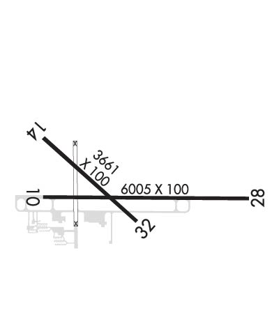
| Lat: N 4207.7 Long: W 08625.5 Elev: 649 Var: +04 Longest Runway: 6006 | ||
| Clr Del: 119.7 AWOS: 121.55 CTAF: 123.0 | ||
| ||||||
| ||||||
|
| Rwy | Rwy | |||||||
| 6006x100 | 6006' | 6006x100 | 6006' | 108.50 - 274° | ||||
| 3205x60 | 3205' | 3205x60 | 3205' | |||||
| Runway ID | Single Wheel | Double Wheel | Double Tandem Wheel | Dual Double Wheel |
| 10/28 | 60,000 | 100,000 | 100,000 | N/A |
| 14/32 | 30,000 | 45,000 | N/A | N/A |
| These numbers are Advisory and are not limits. The Airport Manager should have more accurate Weight Limits | ||||
 Airport Diagram might not be current. | |
| Facility Name: | SOUTHWEST MICHIGAN RGNL |
| City Name: | BENTON HARBOR |
| County: | BERRIEN |
| State abbrev: | MI |
| State Name: | MICHIGAN |
| Ownership: | PUBLICLY OWNED |
| Use: | OPEN TO THE PUBLIC |
| Owner's Name: | BENTON HARBOR/ST JOSEPH |
| Address: | 1123 TERRITORIAL RD |
| BENTON HARBOR, MI 49022-2939 | |
| Owner's Phone: | 269-927-3194 |
| Manager's Name: | VINCENT DESJARDINS |
| Address: | 1123 TERRITORIAL RD |
| BENTON HARBOR, MI 49022-2939 | |
| Phone: | 269-927-3194; EXTN 10; CELL 269-921-9200. |
| FAA Region: | GREAT LAKES |
| FAA Field Office: | DET |
| Date | Sunrise | Sunset |
|---|---|---|
| 09/24/21 Friday | 7:35 | 19:40 |
| 09/25/21 Saturday | 7:36 | 19:38 |
| 09/26/21 Sunday | 7:37 | 19:36 |
| 09/27/21 Monday | 7:38 | 19:35 |
| 09/28/21 Tuesday | 7:39 | 19:33 |
| 09/29/21 Wednesday | 7:40 | 19:31 |
| 09/30/21 Thursday | 7:41 | 19:29 |
| 10/01/21 Friday | 7:42 | 19:28 |
| 10/02/21 Saturday | 7:44 | 19:26 |
| 10/03/21 Sunday | 7:45 | 19:24 |
| 10/04/21 Monday | 7:46 | 19:22 |
| 10/05/21 Tuesday | 7:47 | 19:21 |
| 10/06/21 Wednesday | 7:48 | 19:19 |
| 10/07/21 Thursday | 7:49 | 19:17 |
| Airport Attendance Schedule | MON-FRI 0800-1700, SAT 0800-1400; UNATNDD MAJ HOL, OTR TIMES BY REQ: CALL 269-925-5114 DURG BUS HRS TO REQ AFTR HRS SERV. CALL IN FEE $75. |
| Airport Status | OPERATIONAL (This Status can change at any time - please check NOTAMS) |
| Airport Lighting Schedule | ACTVT MALSR RWY 28; REIL RWY 14 & 32; PAPI RWY 10/28 & 14/32; HIRL RWY 10/28; MIRL RWY 14/32 - CTAF. |
| Airport Storage Available | Tie Downs, Hanger |
| Extra Services Available | Air Ambulance, Cargo Handling, Charter, Aircraft Sales |
| Wind Indicator | YES - (lighted) |
| Control Tower | NO |
| CTAF Frequency | 123.000 |
| Unicom Frequency | 123.000 |
| Rotating Beacon Color | CLEAR-GREEN (Light Land Airport) |
| Segmented Circle | YES |
| Landing Fee | YES; LDG FEE FOR ALL MULTI-ENGINE & COML SINGLE ENGINE ACFT WAIVED WITH MIN FUEL PURCHASE. |
| Airport Inspected | STATE - performed by STATE AERONAUTICAL PERSONNEL |
| Inspection Date | 09/24/2018 |
| Type of Fuel Available | Grade 100LL, JET A-1 (icing inhibitor, freeze point -50C); -A1FOR SVC AFTER HRS CALL 269-325-7529. CALL-IN FEE. |
| Airframe Repair Service | MAJOR |
| Power Plant Repair Service | MAJOR |
| Latitude | N4207.7 |
| Longitude | W08625.5 (ESTIMATED) |
| Arpt Elevation | 649ft (SURVEYED) |
| Magnetic Variation | 04W |
| 2 miles NE | of BENTON HARBOR |
| Traffic Pattern Altitude | |
| Sectional Chart | CHICAGO |
| Operations (Reported) | Yearly | Avg. Daily |
|---|---|---|
| General Aviation Transient | 8625 | 24 |
| General Aviation Local | 8625 | 24 |
| Air Taxi | 1000 | 3 |
| Commerical | 0 | 0 |
| Commuter | 0 | 0 |
| Military | 100 | 0 |
| Aircraft based on Field | |
|---|---|
| General Aviation Singles | 50 |
| General Aviation Multi | 8 |
| Jet Aircraft | 7 |
| General Aviation Helicopters | 0 |
| Military Aircraft | 0 |
| Gliders | 0 |
| Ultralights | 0 |
| FSS on field | NO |
| FSS tie-in | LANSING |
| FSS Phone | 1-800-WX-BRIEF |
| Who issues Notams | BEH |
| Notam D service at airport | YES |
| ARTCC Name | CHICAGO |
| Airport Certification | |
| Aircraft Rescue & Firefighting Index | None |
| Airport of Entry | No |
| Custom Landing Rights | No |
| Joint Civil/Military | No |
| Military Landing rights | YES |
| NATIONAL PLAN OF INTEGRATED AIRPORT SYSTEMS (NPIAS) |
| GRANT AGREEMENTS UNDER FAAP/ADAP/AIP |
| ASSURANCES PURSUANT TO TITLE VI, CIVIL RIGHTS ACT OF 1964 |
| BIRDS AND DEER ON & INVOF ARPT. |
| FOR FIELD COND 269-921-9200 (AMGR CELL). |
| FIELD CONDITIONS NOT MONITORED AFTR ATND HRS. |
| FOR CD CTC CHICAGO ARTCC AT 630-906-8921. |
| RY 14: DROP OFF BEGINS 90 FT FM PAVED SFC. |
| SNOW REM OPNS WINT MONTHS, VEH OPERATORS WILL MONITOR CTAF. |
| (CONTACT PHONE NR) CELL. |
Airport Communications & Frequencies:
| |||||||||||||||||||
| Runway: 10 | Runway: 28 | ||
| Mag heading: | 94° | Mag heading: | 274° |
| Rwy Slope: | .36% Up | Rwy Slope: | -.36% Down |
| Approach: | Approach: | ILS/DME | |
| Pattern: | Left Traffic | Pattern: | Left Traffic |
| Markings: | PRECISION INSTRUMENT | Markings: | PRECISION INSTRUMENT |
| Marking Condition: | GOOD | Marking Condition: | GOOD |
| Arresting Dev: | Arresting Dev: | ||
| Lat & Long: | N4207.7 W08626.0 | Lat. & Long.: | N4207.7 W08624.7 |
| Elev: | 627.5 ft. MSL | Elev: | 649.1 ft. MSL |
| TCH: | 34 ft. AGL | TCH: | 44 ft. AGL |
| Visual Glide Path: | 3.00 degrees | Visual Glide Path: | 3.00 degrees |
| Displaced Threshold: | No | Displaced Threshold: | No |
| Touchdown Zone: | YES | Touchdown Zone: | YES |
| Touchdown Elev.: | 631.3 feet | Touchdown Elev.: | 649.1 feet |
| Visual Glide Slope: | 4-Light PAPI on LEFT side of Runway | Visual Glide Slope: | 4-Light PAPI on LEFT side of Runway |
| RVR Equipment: | RVR Equipment: | ||
| RVV Equipment: | NO | RVV Equipment: | NO |
| Approach Lights: | Approach Lights: | MALSR - 1,400 foot medium intensity approach lighting system with runway alignment indicator lights | |
| REIL: | YES | REIL: | NO |
| Centerline Lights: | NO | Centerline Lights: | NO |
| Touchdown lights: | NO | Touchdown lights: | NO |
| Runway Category: | Runway with a Non-precision Approach having visibility minimums greater than 3/4 mile | Runway Category: | Precision Instrument Runway |
| Declared Distances: | Declared Distances: | ||
| Obstructions: | TREES | Obstructions: | TREES |
| Marked: | NOT Marked/Lighted | Marked: | NOT Marked/Lighted |
| Clearance slope: | 27:1 | Clearance slope: | 20:1 |
| Obstruction height: | 63 feet AGL | Obstruction height: | 21 feet AGL |
| Dist. from runway: | 1960 feet | Dist. from runway: | 624 feet |
| Centerline offset: | 775 right of centerline | Centerline offset: | 560 feet left of centerline |
| Comments: | Comments: |
| Runway: 14 | Runway: 32 | ||
| Mag heading: | 136° | Mag heading: | 316° |
| Rwy Slope: | .13% Up | Rwy Slope: | -.13% Down |
| Approach: | Approach: | ||
| Pattern: | Left Traffic | Pattern: | Left Traffic |
| Markings: | BASIC | Markings: | BASIC |
| Marking Condition: | FAIR | Marking Condition: | FAIR |
| Arresting Dev: | Arresting Dev: | ||
| Lat & Long: | N4207.9 W08626.0 | Lat. & Long.: | N4207.6 W08625.5 |
| Elev: | 627.0 ft. MSL | Elev: | 631.2 ft. MSL |
| TCH: | 36 ft. AGL | TCH: | 36 ft. AGL |
| Visual Glide Path: | 3.50 degrees | Visual Glide Path: | 3.50 degrees |
| Displaced Threshold: | No | Displaced Threshold: | No |
| Touchdown Zone: | YES | Touchdown Zone: | YES |
| Touchdown Elev.: | 630.5 feet | Touchdown Elev.: | 631.2 feet |
| Visual Glide Slope: | 2-Light PAPI on LEFT side of Runway | Visual Glide Slope: | 2-Light PAPI on LEFT side of Runway |
| RVR Equipment: | RVR Equipment: | ||
| RVV Equipment: | NO | RVV Equipment: | NO |
| Approach Lights: | Approach Lights: | ||
| REIL: | YES | REIL: | YES |
| Centerline Lights: | NO | Centerline Lights: | NO |
| Touchdown lights: | NO | Touchdown lights: | NO |
| Runway Category: | Runway with a Visual Approach | Runway Category: | Runway with a Visual Approach |
| Declared Distances: | Declared Distances: | ||
| Obstructions: | TREE | Obstructions: | Unknown |
| Marked: | NOT Marked/Lighted | Marked: | NOT Marked/Lighted |
| Clearance slope: | 21:1 | Clearance slope: | 19:1 |
| Obstruction height: | 75 feet AGL | Obstruction height: | 45 feet AGL |
| Dist. from runway: | 1785 feet | Dist. from runway: | 1055 feet |
| Centerline offset: | 225 left of centerline | Centerline offset: | 200 feet right of centerline |
| Comments: | Comments: |
Thanks for using FltPlan.com
all rights reserved © 1999-2021 by Flight Plan LLC
