
| LAURENCE G HANSCOM FLD BEDFORD MA |
| |
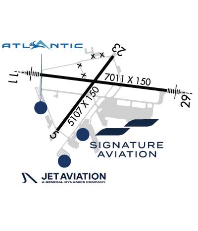
| Lat: N 4228.2 Long: W 07117.3 Elev: 132 Var: +16 Longest Runway: 7011 | ||
| Clr Del: 121.85 Dept. ATIS: 124.6 Arr. ATIS: 124.6 AWOS: 124.6 Ground: 121.7 Tower: 118.5 | ||

| |||||||||||||||||||||||||||||||||||||||||||||||||||||||||||||||||||||
| |||||||||||||||||||||||||||||||||||||||||||||||||||||||||||||||||||||
| |||||||||||||||||||||||||||||||||||||||||||||||||||||||||||||||||||||
| |||||||||||||||||||||||||||||||||||||||||||||||||||||||||||||||||||||
| |||||||||||||||||||||||||||||||||||||||||||||||||||||||||||||||||||||
| |||||||||||||||||||||||||||||||||||||||||||||||||||||||||||||||||||||
| Rwy | Rwy | |||||||
| 5107x150 | 5107' | 5107x150 | 5107' | |||||
| 7011x150 | 7011' | 111.15 - 113° | 7011x150 | 7011' | 111.15 - 293° | |||
| Runway ID | Single Wheel | Double Wheel | Double Tandem Wheel | Dual Double Wheel |
| 05/23 | 120,000 | 250,000 | 436,000 | N/A |
| 11/29 | 120,000 | 250,000 | 455,000 | N/A |
| These numbers are Advisory and are not limits. The Airport Manager should have more accurate Weight Limits | ||||
 Airport Diagram might not be current. | |
| Facility Name: | LAURENCE G HANSCOM FLD |
| City Name: | BEDFORD |
| County: | MIDDLESEX |
| State abbrev: | MA |
| State Name: | MASSACHUSETTS |
| Ownership: | PUBLICLY OWNED |
| Use: | OPEN TO THE PUBLIC |
| Owner's Name: | MASS PORT AUTHORITY |
| Address: | ONE HARBORSIDE DR |
| E BOSTON, MA 02128 | |
| Owner's Phone: | (781) 869-8000 |
| Manager's Name: | SHARON M. WILLIAMS |
| Address: | MASSPORT, 200 HANSCOM DRIVE |
| BEDFORD, MA 01730 | |
| Phone: | 781-869-8000 |
| FAA Region: | NEW ENGLAND |
| FAA Field Office: | NONE |

| Date | Sunrise | Sunset |
|---|---|---|
| 09/24/21 Friday | 6:34 | 18:39 |
| 09/25/21 Saturday | 6:35 | 18:38 |
| 09/26/21 Sunday | 6:36 | 18:36 |
| 09/27/21 Monday | 6:38 | 18:34 |
| 09/28/21 Tuesday | 6:39 | 18:32 |
| 09/29/21 Wednesday | 6:40 | 18:31 |
| 09/30/21 Thursday | 6:41 | 18:29 |
| 10/01/21 Friday | 6:42 | 18:27 |
| 10/02/21 Saturday | 6:43 | 18:25 |
| 10/03/21 Sunday | 6:44 | 18:24 |
| 10/04/21 Monday | 6:45 | 18:22 |
| 10/05/21 Tuesday | 6:46 | 18:20 |
| 10/06/21 Wednesday | 6:47 | 18:18 |
| 10/07/21 Thursday | 6:49 | 18:17 |
| Airport Attendance Schedule | CONTINUOUS |
| Airport Status | OPERATIONAL (This Status can change at any time - please check NOTAMS) |
| Airport Lighting Schedule | ACTVT MALSR RWY 11 & 29; REIL RWY 05 & 23; HIRL RWY 11/29; MIRL RWY 05/23; TWY LGTS - 118.5. |
| Airport Storage Available | Tie Downs, Hanger |
| Extra Services Available | Air Freight, Air Ambulance, Avionics, Charter, Flight Instruction, Aircraft Rental, Aircraft Sales |
| Wind Indicator | YES - (lighted) |
| Control Tower | YES |
| CTAF Frequency | 118.500 |
| Unicom Frequency | 122.950 |
| Rotating Beacon Color | CLEAR-GREEN (Light Land Airport) |
| Segmented Circle | YES |
| Landing Fee | YES; SURCHARGE FOR EACH LDG & DEP 2300-0700. COML & TSNT LDG FEE. |
| Airport Inspected | FEDERAL - performed by FAA AIRPORTS FIELD PERSONNEL |
| Inspection Date | 10/04/2018 |
| Type of Fuel Available | Grade 100LL, JET A (freeze point -40C) |
| Airframe Repair Service | MAJOR |
| Power Plant Repair Service | MAJOR |
| Latitude | N4228.2 |
| Longitude | W07117.3 (ESTIMATED) |
| Arpt Elevation | 132ft (SURVEYED) |
| Magnetic Variation | 16W |
| 0 miles NE | of BEDFORD |
| Traffic Pattern Altitude | 1000 FT AGL FIXED WING; 1500 FT AGL TURBOJET; 1800 FT AGL HEAVY JET ACFT. |
| Sectional Chart | NEW YORK |
| Operations (Reported) | Yearly | Avg. Daily |
|---|---|---|
| General Aviation Transient | 42280 | 116 |
| General Aviation Local | 56253 | 154 |
| Air Taxi | 22379 | 61 |
| Commerical | 319 | 1 |
| Commuter | 0 | 0 |
| Military | 433 | 1 |
| Aircraft based on Field | |
|---|---|
| General Aviation Singles | 140 |
| General Aviation Multi | 20 |
| Jet Aircraft | 75 |
| General Aviation Helicopters | 12 |
| Military Aircraft | 0 |
| Gliders | 0 |
| Ultralights | 0 |
| FSS on field | NO |
| FSS tie-in | BRIDGEPORT |
| FSS Phone | 1-800-WX-BRIEF |
| Who issues Notams | BED |
| Notam D service at airport | YES |
| ARTCC Name | BOSTON |
| Airport Certification | AIRPORT RECEIVING SCHEDULED AIR CARRIER SERVICE FROM CARRIERS CERTIFICATED BY THE CIVIL AERONAUTICS BOARD; CLSD TO PART 121 ACR OPS WITH OVER 60 SEATS EXCP 24 HR PPR CALL 781-869-8000. |
| Aircraft Rescue & Firefighting Index | AIRPORT HAS A CERTIFICATE UNDER CFR PART 139 |
| Airport of Entry | No |
| Custom Landing Rights | YES; US CUSTOMS USER FEE ARPT. |
| Joint Civil/Military | No |
| Military Landing rights | YES |
| NATIONAL PLAN OF INTEGRATED AIRPORT SYSTEMS (NPIAS) |
| GRANT AGREEMENTS UNDER FAAP/ADAP/AIP |
| SURPLUS PROPERTY AGREEMENT UNDER PUBLIC LAW 289 |
| SURPLUS PROPERTY AGREEMENT UNDER REGULATION 16-WAA |
| ASSURANCES PURSUANT TO TITLE VI, CIVIL RIGHTS ACT OF 1964 |
| AGREEMENT UNDER DLAND OR DCLA HAS EXPIRED. |
| PPR FOR ALL ACFT CARRYING EXPLOSIVES CALL 781-869-8000. |
| TWY C, F, J, R, S, T, TWY M SOUTH OF TWY E & TWY G BTN RWY 11/29 & RWY 05/23 CLSD TO ACFT GTR THAN 118 FT WINGSPAN. TWY N CLSD PERMLY. |
| NO PLAS/TGLS FOR ACFT UNDER 12500 LBS BTN 2300-0700. |
| SVC-TRAN ALERT: OPR 1200-0400Z++ WKD; 1400-2200Z++ SUN; PPR OT AND HOL DSN 845-5589/5592. DE-ICING AVBL FR VENDOR. |
| AF: PPR ALL MIL ACFT, PAX MNFST REQ ALL INBD PAX, CTC BASE OPS DSN 845-5589/5592, C781-225-5589/5592. |
| AF: COMD POST DSN 845-6960/6961, C781-225-6960/6961. |
| NO PLAS/TGLS FOR ACFT 12500 LBS & OVER. |
| VOLUNTARY NOISE ABATEMENT PROCS IN EFCT CTC AMGR 781-869-8000. NOISE SENSITIVE HISTORIC AREA S OF ARPT; FOR RWY 23 DEP CONT RWY HDG TO 1000 FT AGL, TURNING CROSSWIND OVR RTE 2. |
| PPR FOR MAINT ENG RUN - CTC AMGR. |
| NOISE RULES IN EFCT - HELS OPERG WI CNTLD ASP ARE RQRD TO MNTN HIST PSBL ALT. |
| SUPPORT: OPR 1200-0400Z++ MON-FRI, 1300-1900Z++ SAT & SUN, CLSD HOL. CTC BASE OPS PRIOR TO 1700Z++ FRI FOR OT SUPPORT. |
| BIRDS & WILDLIFE ON & INVOF ARPT. |
| BE ALERT FOR SML ACFT PARKED ON RAMPS. |
| (A23) RWY 29 RIGHT TFC ACFT OVR 12500 LBS. |
Airport Communications & Frequencies:
| ||||||||||||||||||||||||||||
| Runway: 05 | Runway: 23 | ||
| Mag heading: | 53° | Mag heading: | 233° |
| Rwy Slope: | .00% Down | Rwy Slope: | .00% Up |
| Approach: | Approach: | ||
| Pattern: | Left Traffic | Pattern: | Left Traffic |
| Markings: | NONPRECISION INSTRUMENT | Markings: | NONPRECISION INSTRUMENT |
| Marking Condition: | GOOD | Marking Condition: | GOOD |
| Arresting Dev: | Arresting Dev: | ||
| Lat & Long: | N4227.8 W07117.8 | Lat. & Long.: | N4228.5 W07117.1 |
| Elev: | 128.0 ft. MSL | Elev: | 127.8 ft. MSL |
| TCH: | 62 ft. AGL | TCH: | 56 ft. AGL |
| Visual Glide Path: | 3.75 degrees | Visual Glide Path: | 3.50 degrees |
| Displaced Threshold: | No | Displaced Threshold: | No |
| Touchdown Zone: | YES | Touchdown Zone: | YES |
| Touchdown Elev.: | 128.1 feet | Touchdown Elev.: | 128.1 feet |
| Visual Glide Slope: | 4-BOX VASI ON LEFT SIDE OF RUNWAY; OTS UFN. | Visual Glide Slope: | 4-BOX VASI ON RIGHT SIDE OF RUNWAY |
| RVR Equipment: | RVR Equipment: | ||
| RVV Equipment: | NO | RVV Equipment: | NO |
| Approach Lights: | Approach Lights: | ||
| REIL: | YES | REIL: | YES |
| Centerline Lights: | NO | Centerline Lights: | NO |
| Touchdown lights: | NO | Touchdown lights: | NO |
| Runway Category: | Runway with a Visual Approach | Runway Category: | Runway with a Non-precision Approach having visibility minimums greater than 3/4 mile |
| Declared Distances: | TORA:5107' TODA:5107' ASDA:5107' LDA:5107' | Declared Distances: | TORA:5107' TODA:5107' ASDA:5107' LDA:5107' |
| Runway: 11 | Runway: 29 | ||
| Mag heading: | 113° | Mag heading: | 293° |
| Rwy Slope: | -.13% Down | Rwy Slope: | .13% Up |
| Approach: | ILS/DME | Approach: | ILS/DME |
| Pattern: | Left Traffic | Pattern: | Left Traffic |
| Markings: | PRECISION INSTRUMENT | Markings: | PRECISION INSTRUMENT |
| Marking Condition: | GOOD | Marking Condition: | GOOD |
| Arresting Dev: | Arresting Dev: | ||
| Lat & Long: | N4228.3 W07118.0 | Lat. & Long.: | N4228.2 W07116.5 |
| Elev: | 132.0 ft. MSL | Elev: | 123.0 ft. MSL |
| TCH: | 67 ft. AGL | TCH: | 52 ft. AGL |
| Visual Glide Path: | 3.00 degrees | Visual Glide Path: | 3.00 degrees |
| Displaced Threshold: | No | Displaced Threshold: | No |
| Touchdown Zone: | YES | Touchdown Zone: | YES |
| Touchdown Elev.: | 132.0 feet | Touchdown Elev.: | 127.9 feet |
| Visual Glide Slope: | 4-Light PAPI on LEFT side of Runway | Visual Glide Slope: | 4-Light PAPI on RIGHT side of Runway |
| RVR Equipment: | TOUCHDOWN | RVR Equipment: | ROLLOUT |
| RVV Equipment: | NO | RVV Equipment: | NO |
| Approach Lights: | MALSR - 1,400 foot medium intensity approach lighting system with runway alignment indicator lights | Approach Lights: | MALSR - 1,400 foot medium intensity approach lighting system with runway alignment indicator lights |
| REIL: | NO | REIL: | NO |
| Centerline Lights: | NO | Centerline Lights: | NO |
| Touchdown lights: | NO | Touchdown lights: | NO |
| Runway Category: | Precision Instrument Runway | Runway Category: | Precision Instrument Runway |
| Declared Distances: | TORA:7011' TODA:7011' ASDA:7011' LDA:7011' | Declared Distances: | TORA:7011' TODA:7011' ASDA:7011' LDA:7011' |
| Obstructions: | HILL | Obstructions: | |
| Marked: | LIGHTED | Marked: | |
| Clearance slope: | 34:1 | Clearance slope: | 34:1 |
| Obstruction height: | 120 feet AGL | Obstruction height: | |
| Dist. from runway: | 1050 feet | Dist. from runway: | |
| Centerline offset: | 734 right of centerline | Centerline offset: | |
| Comments: | Comments: |
Thanks for using FltPlan.com
all rights reserved © 1999-2021 by Flight Plan LLC