| BOULDER MUNI BOULDER CO |
| |
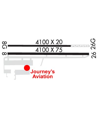
| Lat: N 4002.4 Long: W 10513.6 Elev: 5288 Var: -12 Longest Runway: 4100 | ||
| AWOS: 118.82 CTAF: 122.72 | ||
| |||||||||||||||||||||||||||||||||||||||||||||||||||||||||||||
| |||||||||||||||||||||||||||||||||||||||||||||||||||||||||||||
| |||||||||||||||||||||||||||||||||||||||||||||||||||||||||||||
| |||||||||||||||||||||||||||||||||||||||||||||||||||||||||||||
| Rwy | Rwy | |||||||
| 4100x75 | 3900' | 4100x75 | 4100' | |||||
| 4100x20 | 4100' | 4100x20 | 4100' | |||||
| Runway ID | Single Wheel | Double Wheel | Double Tandem Wheel | Dual Double Wheel |
| 08/26 | 16,000 | N/A | N/A | N/A |
| 08G/26G | N/A | N/A | N/A | N/A |
| These numbers are Advisory and are not limits. The Airport Manager should have more accurate Weight Limits | ||||
| FltPlan does not have IFR approach charts available for KBDU. |
 Airport Diagram might not be current. | |
| Facility Name: | BOULDER MUNI |
| City Name: | BOULDER |
| County: | BOULDER |
| State abbrev: | CO |
| State Name: | COLORADO |
| Ownership: | PUBLICLY OWNED |
| Use: | OPEN TO THE PUBLIC |
| Owner's Name: | CITY OF BOULDER |
| Address: | PO BOX 791 |
| BOULDER, CO 80306 | |
| Owner's Phone: | 303-441-3108 |
| Manager's Name: | DENIS GODFREY |
| Address: | 3327 AIRPORT ROAD |
| BOULDER, CO 80301 | |
| Phone: | 303-441-3108 |
| FAA Region: | NORTHWEST MOUNTAIN |
| FAA Field Office: | DEN |
| Date | Sunrise | Sunset |
|---|---|---|
| 09/24/21 Friday | 6:50 | 18:55 |
| 09/25/21 Saturday | 6:51 | 18:53 |
| 09/26/21 Sunday | 6:52 | 18:52 |
| 09/27/21 Monday | 6:53 | 18:50 |
| 09/28/21 Tuesday | 6:54 | 18:48 |
| 09/29/21 Wednesday | 6:55 | 18:47 |
| 09/30/21 Thursday | 6:56 | 18:45 |
| 10/01/21 Friday | 6:57 | 18:43 |
| 10/02/21 Saturday | 6:58 | 18:42 |
| 10/03/21 Sunday | 6:59 | 18:40 |
| 10/04/21 Monday | 7:00 | 18:39 |
| 10/05/21 Tuesday | 7:01 | 18:37 |
| 10/06/21 Wednesday | 7:02 | 18:35 |
| 10/07/21 Thursday | 7:03 | 18:34 |
| Airport Attendance Schedule | 7 Days A Week 0800-1700 |
| Airport Status | OPERATIONAL (This Status can change at any time - please check NOTAMS) |
| Airport Lighting Schedule | ACTVT PAPI RWY 26; MIRL RWY 8/26 - CTAF. |
| Airport Storage Available | Tie Downs, Hanger |
| Extra Services Available | Glider, Flight Instruction, Parachute Jumping, Aircraft Rental, Aircraft Sales, Glider Towing |
| Wind Indicator | YES - (lighted) |
| Control Tower | NO |
| CTAF Frequency | 122.725 |
| Unicom Frequency | 122.725 |
| Rotating Beacon Color | CLEAR-GREEN (Light Land Airport) |
| Segmented Circle | YES |
| Landing Fee | NO |
| Airport Inspected | STATE - performed by STATE AERONAUTICAL PERSONNEL |
| Inspection Date | 05/07/2018 |
| Type of Fuel Available | Grade 100LL, JET A (freeze point -40C); -10100LL SELF SERVE AVBL H24. |
| Airframe Repair Service | MAJOR |
| Power Plant Repair Service | MAJOR |
| Latitude | N4002.4 |
| Longitude | W10513.6 (ESTIMATED) |
| Arpt Elevation | 5288ft (ESTIMATED) |
| Magnetic Variation | 12E |
| 3 miles NE | of BOULDER |
| Traffic Pattern Altitude | 1012 |
| Sectional Chart | CHEYENNE |
| Operations (Reported) | Yearly | Avg. Daily |
|---|---|---|
| General Aviation Transient | 7277 | 20 |
| General Aviation Local | 49352 | 135 |
| Air Taxi | 0 | 0 |
| Commerical | 0 | 0 |
| Commuter | 0 | 0 |
| Military | 0 | 0 |
| Aircraft based on Field | |
|---|---|
| General Aviation Singles | 36 |
| General Aviation Multi | 6 |
| Jet Aircraft | 0 |
| General Aviation Helicopters | 0 |
| Military Aircraft | 0 |
| Gliders | 19 |
| Ultralights | 0 |
| FSS on field | NO |
| FSS tie-in | DENVER |
| FSS Phone | 1-800-WX-BRIEF |
| Who issues Notams | DEN |
| Notam D service at airport | YES |
| ARTCC Name | DENVER |
| Airport Certification | |
| Aircraft Rescue & Firefighting Index | None |
| Airport of Entry | No |
| Custom Landing Rights | No |
| Joint Civil/Military | No |
| Military Landing rights | YES |
| NATIONAL PLAN OF INTEGRATED AIRPORT SYSTEMS (NPIAS) |
| GRANT AGREEMENTS UNDER FAAP/ADAP/AIP |
| ASSURANCES PURSUANT TO TITLE VI, CIVIL RIGHTS ACT OF 1964 |
| PAJA & WATER FOWL ON & INVOF ARPT. |
| RY 08/26 TPA (1012 FT AGL) 6300 FT MSL; RY 08 DEP, NO TURN BLO (512 FT AGL) 5800 FT MSL. RY 08 PREFERRED UNDER LIGHT WIND CONDITIONS. DURING WEST WIND CONDITIONS EXPECT SEVERE WIND TURBULENCE APPROACHING AND DEPARTING RY 26. |
| SIMULTANEOUS APCHS TO & DEP FM RWY 8/26 & 8G/26G PROHIBITED; PWRD ACFT YIELD RIGHT OF WAY TO GLIDERS ON FINAL OR INITIATE GO-AROUND FOR ADEQUATE SPACING. |
| CTN: USAF STUDENT TRNG INVOF COLORADO SPRINGS & PUEBLO ARPT. |
| MIDFIELD PAT ENTRY FM S AVBL FOR GLIDER USE ONLY. |
| FOR CD CTC DENVER APCH AT 303-342-1916. |
| GLIDER ACT DLY SR-SS SE OF ARPT BTN ARPT & POWER PLANT FM 6300 - 9000 FT; RCMD AVOIDANCE & EXERCIZE EXTREME CTN WHEN TRANSITING AREA. |
| RWY 08 & 08G: 25 - 55 FT TREES OUTLINE HAYDEN LAKE 200 FT FM 08G THR; HAYDEN LAKE LCTD 250 FT FM RWY 8 & 8G THRS. |
| NOISE ABATEMENT PROC IN EFCT - AMGR OR HTTP:/WWW.BOULDERCOLORADO.GOV/AIRPORT. |
| RWY 08G/ 26GLNDG AREA UNDEFINED; GLIDER OPS ONLY; 197 FT SEPN CNTRLN TO CNTRLN. GLIDER OPS AS CLOSE AS 60 FT PARALLEL TO RWY 8/26. |
| RWY 26 300 FT SAFETY AREA OUTLINED WITH RED REFLECTORS; 130 FT DROPOFF E OF MKD AREA. |
| RWY 08G/ 26G3000 FT X 20 FT CHIP & SEAL W END; 1100 FT GRASS E END. |
| Runway: 08 | Runway: 26 | ||
| Mag heading: | 78° | Mag heading: | 258° |
| Rwy Slope: | -.22% Down | Rwy Slope: | .22% Up |
| Approach: | Approach: | ||
| Pattern: | Left Traffic | Pattern: | Right Traffic |
| Markings: | BASIC | Markings: | BASIC |
| Marking Condition: | GOOD | Marking Condition: | GOOD |
| Arresting Dev: | Arresting Dev: | ||
| Lat & Long: | N4002.3 W10514.0 | Lat. & Long.: | N4002.3 W10513.1 |
| Elev: | 5288.0 ft. MSL | Elev: | 5278.8 ft. MSL |
| TCH: | TCH: | 40 ft. AGL | |
| Visual Glide Path: | Visual Glide Path: | 3.50 degrees | |
| Displaced Threshold: | 200 feet | Displaced Threshold: | No |
| Touchdown Zone: | YES | Touchdown Zone: | YES |
| Touchdown Elev.: | 5288.0 feet | Touchdown Elev.: | 5278.8 feet |
| Visual Glide Slope: | Visual Glide Slope: | 4-Light PAPI on LEFT side of Runway | |
| RVR Equipment: | RVR Equipment: | ||
| RVV Equipment: | NO | RVV Equipment: | NO |
| Approach Lights: | Approach Lights: | ||
| REIL: | NO | REIL: | NO |
| Centerline Lights: | NO | Centerline Lights: | NO |
| Touchdown lights: | NO | Touchdown lights: | NO |
| Runway Category: | Runway with a Visual Approach | Runway Category: | Runway with a Visual Approach |
| Declared Distances: | TORA:4100' TODA:4100' ASDA:4100' LDA:3900' | Declared Distances: | TORA:4100' TODA:4100' ASDA:3900' LDA:3900' |
| Obstructions: | TREES | Obstructions: | |
| Marked: | NOT Marked/Lighted | Marked: | |
| Clearance slope: | 19:1 | Clearance slope: | 50:1 |
| Obstruction height: | 60 feet AGL | Obstruction height: | |
| Dist. from runway: | 1350 feet | Dist. from runway: | |
| Centerline offset: | Centerline offset: | ||
| Comments: | Comments: |
| Runway: 08G | Runway: 26G | ||
| Mag heading: | N/A | Mag heading: | N/A |
| Rwy Slope: | -.32% Down | Rwy Slope: | .32% Up |
| Approach: | Approach: | ||
| Pattern: | Left Traffic | Pattern: | Right Traffic |
| Markings: | Markings: | ||
| Marking Condition: | Marking Condition: | ||
| Arresting Dev: | Arresting Dev: | ||
| Lat & Long: | N4002.4 W10514.0 | Lat. & Long.: | N4002.4 W10513.1 |
| Elev: | 5287.0 ft. MSL | Elev: | 5274.0 ft. MSL |
| TCH: | TCH: | ||
| Visual Glide Path: | Visual Glide Path: | ||
| Displaced Threshold: | No | Displaced Threshold: | No |
| Touchdown Zone: | NO | Touchdown Zone: | NO |
| Touchdown Elev.: | Touchdown Elev.: | ||
| Visual Glide Slope: | Visual Glide Slope: | ||
| RVR Equipment: | RVR Equipment: | ||
| RVV Equipment: | NO | RVV Equipment: | NO |
| Approach Lights: | Approach Lights: | ||
| REIL: | NO | REIL: | NO |
| Centerline Lights: | NO | Centerline Lights: | NO |
| Touchdown lights: | NO | Touchdown lights: | NO |
| Runway Category: | Runway with a Visual Approach | Runway Category: | Runway with a Visual Approach |
| Declared Distances: | Declared Distances: | ||
| Obstructions: | TREES | Obstructions: | |
| Marked: | NOT Marked/Lighted | Marked: | |
| Clearance slope: | 3:1 | Clearance slope: | 50:1 |
| Obstruction height: | 60 feet AGL | Obstruction height: | |
| Dist. from runway: | 200 feet | Dist. from runway: | |
| Centerline offset: | 126 left of centerline | Centerline offset: | |
| Comments: | Comments: |
Thanks for using FltPlan.com
all rights reserved © 1999-2021 by Flight Plan LLC