
| BLANDING MUNI BLANDING UT |
| |
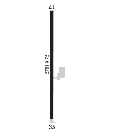
| Lat: N 3735.0 Long: W 10929.0 Elev: 5868 Var: -12 Longest Runway: 5781 | ||
| AWOS: 127.75 CTAF: 122.8 | ||
| ||||||||||||||||||||||||||||||||||||||||||||
| ||||||||||||||||||||||||||||||||||||||||||||
| ||||||||||||||||||||||||||||||||||||||||||||
| Rwy | Rwy | |||||||
| 5781x75 | 5781' | 5781x75 | 5781' | |||||
| Runway ID | Single Wheel | Double Wheel | Double Tandem Wheel | Dual Double Wheel |
| 17/35 | 27,000 | N/A | N/A | N/A |
| These numbers are Advisory and are not limits. The Airport Manager should have more accurate Weight Limits | ||||
 Airport Diagram might not be current. | |
| Facility Name: | BLANDING MUNI |
| City Name: | BLANDING |
| County: | SAN JUAN |
| State abbrev: | UT |
| State Name: | UTAH |
| Ownership: | PUBLICLY OWNED |
| Use: | OPEN TO THE PUBLIC |
| Owner's Name: | BLANDING CITY |
| Address: | 50 WEST 100 SOUTH |
| BLANDING, UT 84511 | |
| Owner's Phone: | 435-678-2791 |
| Manager's Name: | TAYLOR FRANCOM; DIR COMM. DEV/ARPT MGR. 435-678-2791. |
| Address: | 50 WEST 100 SOUTH |
| BLANDING, UT 84511 | |
| Phone: | 435-678-2791; FBO/ARPT ATTENDANT. |
| FAA Region: | NORTHWEST MOUNTAIN |
| FAA Field Office: | DEN |
| Date | Sunrise | Sunset |
|---|---|---|
| 06/08/26 Monday | 5:56 | 20:38 |
| 06/09/26 Tuesday | 5:56 | 20:38 |
| 06/10/26 Wednesday | 5:56 | 20:39 |
| 06/11/26 Thursday | 5:56 | 20:39 |
| 06/12/26 Friday | 5:56 | 20:40 |
| 06/13/26 Saturday | 5:56 | 20:40 |
| 06/14/26 Sunday | 5:56 | 20:40 |
| 06/15/26 Monday | 5:56 | 20:41 |
| 06/16/26 Tuesday | 5:56 | 20:41 |
| 06/17/26 Wednesday | 5:56 | 20:42 |
| 06/18/26 Thursday | 5:56 | 20:42 |
| 06/19/26 Friday | 5:56 | 20:42 |
| 06/20/26 Saturday | 5:57 | 20:42 |
| 06/21/26 Sunday | 5:57 | 20:43 |
| Airport Attendance Schedule | CONTINUOUS |
| Airport Status | OPERATIONAL (This Status can change at any time - please check NOTAMS) |
| Airport Lighting Schedule | ACTVT MIRL RWY 17/35, REIL - CTAF. PAPI RWY 17 & 35 OPER CONSLY. |
| Airport Storage Available | Tie Downs |
| Extra Services Available | Air Ambulance |
| Wind Indicator | YES - (lighted) |
| Control Tower | NO |
| CTAF Frequency | 122.800 |
| Unicom Frequency | 122.800 |
| Rotating Beacon Color | WG |
| Segmented Circle | YES |
| Landing Fee | NO |
| Airport Inspected | STATE - performed by PRIVATE CONTRACT PERSONNEL |
| Inspection Date | 10/01/2023 |
| Type of Fuel Available | Grade 100LL, JET A (freeze point -40C); -1024 HR FULL & SELF-SVC. CALL-IN & RAMP SVC FEE WAIVED WITH MIN FUEL PURCHASE. |
| Airframe Repair Service | NONE |
| Power Plant Repair Service | NONE |
| Latitude | N3735.0 |
| Longitude | W10929.0 (ESTIMATED) |
| Arpt Elevation | 5867ft (SURVEYED) |
| Magnetic Variation | 12E |
| 3 miles S | of BLANDING |
| Traffic Pattern Altitude | |
| Sectional Chart | DENVER |
| Operations (Reported) | Yearly | Avg. Daily |
|---|---|---|
| General Aviation Transient | 0 | 0 |
| General Aviation Local | 0 | 0 |
| Air Taxi | 0 | 0 |
| Commerical | 0 | 0 |
| Commuter | 0 | 0 |
| Military | 0 | 0 |
| Aircraft based on Field | |
|---|---|
| General Aviation Singles | 0 |
| General Aviation Multi | 0 |
| Jet Aircraft | 0 |
| General Aviation Helicopters | 0 |
| Military Aircraft | 0 |
| Gliders | 0 |
| Ultralights | 0 |
| FSS on field | NO |
| FSS tie-in | CEDAR CITY |
| FSS Phone | 1-800-WX-BRIEF |
| Who issues Notams | CDC |
| Notam D service at airport | YES |
| ARTCC Name | DENVER |
| Airport Certification | |
| Aircraft Rescue & Firefighting Index | None |
| Airport of Entry | No |
| Custom Landing Rights | No |
| Joint Civil/Military | No |
| Military Landing rights | YES |
| NATIONAL PLAN OF INTEGRATED AIRPORT SYSTEMS (NPIAS) |
| GRANT AGREEMENTS UNDER FAAP/ADAP/AIP |
| ASSURANCES PURSUANT TO TITLE VI, CIVIL RIGHTS ACT OF 1964 |
| WILDLIFE ON AND INVOF ARPT. |
| FOR CD CTC DENVER ARTCC AT 303-651-4257. |
Airport Communications & Frequencies:
| |||||||||
| Runway: 17 | Runway: 35 | ||
| Mag heading: | 168° | Mag heading: | 348° |
| Rwy Slope: | -1.61% Down | Rwy Slope: | 1.61% Up |
| Approach: | Approach: | ||
| Pattern: | Left Traffic | Pattern: | Left Traffic |
| Markings: | BASIC | Markings: | NONPRECISION INSTRUMENT |
| Marking Condition: | POOR; RWY MKGS FADED. | Marking Condition: | POOR; RWY MKGS FADED. |
| Arresting Dev: | Arresting Dev: | ||
| Lat & Long: | N3735.5 W10929.0 | Lat. & Long.: | N3734.5 W10929.0 |
| Elev: | 5867.8 ft. MSL | Elev: | 5774.5 ft. MSL |
| TCH: | 40 ft. AGL | TCH: | 40 ft. AGL |
| Visual Glide Path: | 3.00 degrees | Visual Glide Path: | 3.00 degrees |
| Displaced Threshold: | No | Displaced Threshold: | No |
| Touchdown Zone: | YES | Touchdown Zone: | YES |
| Touchdown Elev.: | 5867.8 feet | Touchdown Elev.: | 5820.6 feet |
| Visual Glide Slope: | 2-Light PAPI on LEFT side of Runway | Visual Glide Slope: | 2-Light PAPI on LEFT side of Runway |
| RVR Equipment: | RVR Equipment: | ||
| RVV Equipment: | NO | RVV Equipment: | NO |
| Approach Lights: | Approach Lights: | ||
| REIL: | YES | REIL: | YES |
| Centerline Lights: | NO | Centerline Lights: | NO |
| Touchdown lights: | NO | Touchdown lights: | NO |
| Runway Category: | Runway with a Visual Approach | Runway Category: | Runway with a Non-precision Approach having visibility minimums greater than 3/4 mile |
| Declared Distances: | Declared Distances: | ||
| Obstructions: | Obstructions: | ROAD | |
| Marked: | Marked: | NOT Marked/Lighted | |
| Clearance slope: | 50:1 | Clearance slope: | 28:1 |
| Obstruction height: | Obstruction height: | 15 feet AGL | |
| Dist. from runway: | Dist. from runway: | 620 feet | |
| Centerline offset: | Centerline offset: | ||
| Comments: | Comments: |
Thanks for using FltPlan.com
all rights reserved © 1999-2026 by Flight Plan LLC
