
| VIRGINIATECH/MONTGOMERY EXECUT BLACKSBURG VA |
| |
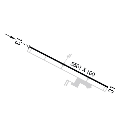
| Lat: N 3712.6 Long: W 08024.7 Elev: 2119 Var: +08 Longest Runway: 5501 | ||
| Clr Del: 124.85 AWOS: 133.32 CTAF: 123.05 | ||
| ||||||||||||||||||||||||||||||||||||||||||||
| ||||||||||||||||||||||||||||||||||||||||||||
| ||||||||||||||||||||||||||||||||||||||||||||
| Rwy | Rwy | |||||||
| 5501x100 | 5501' | 109.10 - 125° | 5501x100 | 5501' | ||||
| Runway ID | Single Wheel | Double Wheel | Double Tandem Wheel | Dual Double Wheel |
| 13/31 | N/A | N/A | N/A | N/A |
| These numbers are Advisory and are not limits. The Airport Manager should have more accurate Weight Limits | ||||
 Airport Diagram might not be current. | |
| Facility Name: | VIRGINIA TECH/MONTGOMERY EXEC |
| City Name: | BLACKSBURG |
| County: | MONTGOMERY |
| State abbrev: | VA |
| State Name: | VIRGINIA |
| Ownership: | PUBLICLY OWNED |
| Use: | OPEN TO THE PUBLIC |
| Owner's Name: | VTMRAA |
| Address: | 1601 RESEARCH CENTER DRIVE |
| BLACKSBURG, VA 24060 | |
| Owner's Phone: | 540-231-4444 |
| Manager's Name: | KEITH HOLT |
| Address: | 1601 RESEARCH CENTER DRIVE |
| BLACKSBURG, VA 24060 | |
| Phone: | 540-231-4444 |
| FAA Region: | EASTERN |
| FAA Field Office: | DCA |
| Date | Sunrise | Sunset |
|---|---|---|
| 06/08/26 Monday | 6:01 | 20:40 |
| 06/09/26 Tuesday | 6:01 | 20:41 |
| 06/10/26 Wednesday | 6:01 | 20:41 |
| 06/11/26 Thursday | 6:01 | 20:42 |
| 06/12/26 Friday | 6:01 | 20:42 |
| 06/13/26 Saturday | 6:01 | 20:43 |
| 06/14/26 Sunday | 6:01 | 20:43 |
| 06/15/26 Monday | 6:01 | 20:43 |
| 06/16/26 Tuesday | 6:01 | 20:44 |
| 06/17/26 Wednesday | 6:01 | 20:44 |
| 06/18/26 Thursday | 6:01 | 20:44 |
| 06/19/26 Friday | 6:01 | 20:45 |
| 06/20/26 Saturday | 6:01 | 20:45 |
| 06/21/26 Sunday | 6:02 | 20:45 |
| Airport Attendance Schedule | 7 Days A Week 0800-1900; UNATNDD NEW YEARS DAY, THANKSGIVING DAY, CHRISTMAS DAY, MAJOR HOLS. |
| Airport Status | OPERATIONAL (This Status can change at any time - please check NOTAMS) |
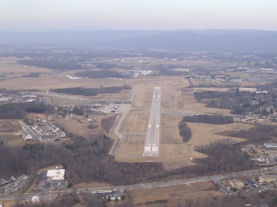
| Airport Lighting Schedule | ACTVT ODALS RWY 13; REIL RWY 31; PAPI RWY 13 & 31; MIRL RWY 13/31 - CTAF. MIRL RWY 13/31 PRESET LOW INTST. |
| Airport Storage Available | Tie Downs |
| Extra Services Available | Charter, Flight Instruction, Aircraft Rental |
| Wind Indicator | YES - (lighted) |
| Control Tower | NO |
| CTAF Frequency | 123.050 |
| Unicom Frequency | 123.050 |
| Rotating Beacon Color | WG |
| Segmented Circle | YES |
| Landing Fee | NO |
| Airport Inspected | STATE - performed by STATE AERONAUTICAL PERSONNEL |
| Inspection Date | 08/05/2025 |
| Type of Fuel Available | Grade 100LL, JET A; -10PPR FOR FUEL WHEN ARPT UNATNDD; PHONE 540-231-4444; FEE FOR AFT HRS. |
| Airframe Repair Service | NONE |
| Power Plant Repair Service | NONE |
| Latitude | N3712.6 |
| Longitude | W08024.7 (ESTIMATED) |
| Arpt Elevation | 2119ft (SURVEYED) |
| Magnetic Variation | 08W |
| 3 miles S | of BLACKSBURG |
| Traffic Pattern Altitude | TPA 1000 FT AGL FOR NON TURBINE POWERED ACFT. TPA FOR TURBINE POWERED ACFT 1500 FT AGL. |
| Sectional Chart | CINCINNATI |
| Operations (Reported) | Yearly | Avg. Daily |
|---|---|---|
| General Aviation Transient | 0 | 0 |
| General Aviation Local | 0 | 0 |
| Air Taxi | 0 | 0 |
| Commerical | 0 | 0 |
| Commuter | 0 | 0 |
| Military | 0 | 0 |
| Aircraft based on Field | |
|---|---|
| General Aviation Singles | 0 |
| General Aviation Multi | 0 |
| Jet Aircraft | 0 |
| General Aviation Helicopters | 0 |
| Military Aircraft | 0 |
| Gliders | 0 |
| Ultralights | 0 |
| FSS on field | NO |
| FSS tie-in | LEESBURG |
| FSS Phone | 1-800-WX-BRIEF |
| Who issues Notams | BCB |
| Notam D service at airport | YES |
| ARTCC Name | WASHINGTON |
| Airport Certification | |
| Aircraft Rescue & Firefighting Index | None |
| Airport of Entry | No |
| Custom Landing Rights | No |
| Joint Civil/Military | No |
| Military Landing rights | YES |
| NATIONAL PLAN OF INTEGRATED AIRPORT SYSTEMS (NPIAS) |
| GRANT AGREEMENTS UNDER FAAP/ADAP/AIP |
| ASSURANCES PURSUANT TO TITLE VI, CIVIL RIGHTS ACT OF 1964 |
| OCCASIONAL WILDLIFE ON ARPT. |
| VFR DEPARTURES MAINTAIN RWY HEADING UNTIL REACHING 1000 FT AGL. |
| NOISE SENSITIVE AREA NORTH OF ARPT. |
| ROA TWR SVCS AVBL AT 540-563-1307. |
| FOR CD CTC ROANOKE APCH AT 540-563-1307. |
Airport Communications & Frequencies:
| ||||||||||||||||
| Runway: 13 | Runway: 31 | ||
| Mag heading: | 125° | Mag heading: | 305° |
| Rwy Slope: | .00% Up | Rwy Slope: | .00% Down |
| Approach: | LOC/DME | Approach: | |
| Pattern: | Left Traffic | Pattern: | Left Traffic |
| Markings: | NONPRECISION INSTRUMENT | Markings: | NONPRECISION INSTRUMENT |
| Marking Condition: | GOOD | Marking Condition: | GOOD |
| Arresting Dev: | Arresting Dev: | ||
| Lat & Long: | N3712.8 W08025.2 | Lat. & Long.: | N3712.4 W08024.2 |
| Elev: | 2119.1 ft. MSL | Elev: | 2119.3 ft. MSL |
| TCH: | 55 ft. AGL | TCH: | 50 ft. AGL |
| Visual Glide Path: | 3.44 degrees | Visual Glide Path: | 3.00 degrees |
| Displaced Threshold: | No | Displaced Threshold: | No |
| Touchdown Zone: | YES | Touchdown Zone: | YES |
| Touchdown Elev.: | 2119.1 feet | Touchdown Elev.: | 2119.4 feet |
| Visual Glide Slope: | 4-Light PAPI on LEFT side of Runway | Visual Glide Slope: | 2-Light PAPI on LEFT side of Runway |
| RVR Equipment: | RVR Equipment: | ||
| RVV Equipment: | NO | RVV Equipment: | NO |
| Approach Lights: | ODALS - omnidirectional approach lighting system | Approach Lights: | |
| REIL: | NO | REIL: | YES |
| Centerline Lights: | NO | Centerline Lights: | NO |
| Touchdown lights: | NO | Touchdown lights: | NO |
| Runway Category: | Runway with a Non-precision Approach having visibility minimums greater than 3/4 mile | Runway Category: | Runway with a Non-precision Approach having visibility minimums greater than 3/4 mile |
| Declared Distances: | Declared Distances: | ||
| Obstructions: | TREE | Obstructions: | TREE |
| Marked: | NOT Marked/Lighted | Marked: | NOT Marked/Lighted |
| Clearance slope: | 15:1 | Clearance slope: | 23:1 |
| Obstruction height: | 59 feet AGL | Obstruction height: | 48 feet AGL |
| Dist. from runway: | 1112 feet | Dist. from runway: | 1341 feet |
| Centerline offset: | 363 left of centerline | Centerline offset: | 395 feet left of centerline |
| Comments: | Comments: |
Thanks for using FltPlan.com
all rights reserved © 1999-2026 by Flight Plan LLC