
| HURON COUNTY MEMORIAL BAD AXE MI |
| |
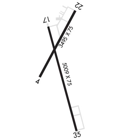
| Lat: N 4346.8 Long: W 08259.1 Elev: 763 Var: +05 Longest Runway: 5009 | ||
| AWOS: 118.6 CTAF: 123.07 | ||
| ||||||
| ||||||
|
| Rwy | Rwy | |||||||
| 3495x75 | 3195' | 3495x75 | 3495' | |||||
| 5009x75 | 5009' | 5009x75 | 5009' | |||||
| Runway ID | Single Wheel | Double Wheel | Double Tandem Wheel | Dual Double Wheel |
| 04/22 | 16,000 | N/A | N/A | N/A |
| 17/35 | N/A | N/A | N/A | N/A |
| These numbers are Advisory and are not limits. The Airport Manager should have more accurate Weight Limits | ||||
 Airport Diagram might not be current. | |
| Facility Name: | HURON COUNTY MEML |
| City Name: | BAD AXE |
| County: | HURON |
| State abbrev: | MI |
| State Name: | MICHIGAN |
| Ownership: | PUBLICLY OWNED |
| Use: | OPEN TO THE PUBLIC |
| Owner's Name: | NEAL J HENTSCHL |
| Address: | PO BOX 270, 417 S HANSELMAN ST |
| BAD AXE, MI 48413 | |
| Owner's Phone: | 989-269-6404 |
| Manager's Name: | CHRIS JACKSON |
| Address: | 352 THOMPSON RD |
| BAD AXE, MI 48413 | |
| Phone: | 989-269-6511 |
| FAA Region: | GREAT LAKES |
| FAA Field Office: | DET |
| Date | Sunrise | Sunset |
|---|---|---|
| 09/24/21 Friday | 7:21 | 19:26 |
| 09/25/21 Saturday | 7:22 | 19:24 |
| 09/26/21 Sunday | 7:23 | 19:22 |
| 09/27/21 Monday | 7:25 | 19:21 |
| 09/28/21 Tuesday | 7:26 | 19:19 |
| 09/29/21 Wednesday | 7:27 | 19:17 |
| 09/30/21 Thursday | 7:28 | 19:15 |
| 10/01/21 Friday | 7:29 | 19:13 |
| 10/02/21 Saturday | 7:30 | 19:11 |
| 10/03/21 Sunday | 7:32 | 19:10 |
| 10/04/21 Monday | 7:33 | 19:08 |
| 10/05/21 Tuesday | 7:34 | 19:06 |
| 10/06/21 Wednesday | 7:35 | 19:04 |
| 10/07/21 Thursday | 7:36 | 19:03 |
| Airport Attendance Schedule | MON-FRI 0830-1630, SAT-SUN UNATND; ARPT UNATNDD WEEKENDS & MAJOR HOLS. |
| Airport Status | OPERATIONAL (This Status can change at any time - please check NOTAMS) |
| Airport Lighting Schedule | MIRL RYS 04/22 & 17/35 OPER DUSK-2130; TO INCR INTST & AFT 2130 ACTVT - CTAF. ACTVT PAPI RYS 4, 17, 22, & 35 AND REIL RYS 17 & 35 - CTAF. |
| Airport Storage Available | NONE |
| Extra Services Available | NONE |
| Wind Indicator | YES - (lighted) |
| Control Tower | NO |
| CTAF Frequency | 123.075 |
| Unicom Frequency | 123.075 |
| Rotating Beacon Color | CLEAR-GREEN (Light Land Airport) |
| Segmented Circle | YES |
| Landing Fee | NO |
| Airport Inspected | STATE - performed by STATE AERONAUTICAL PERSONNEL |
| Inspection Date | 07/10/2019 |
| Type of Fuel Available | Grade 100LL, JET A (freeze point -40C); -A FOR FULL SERVICE CALL 989-269-6511 |
| Airframe Repair Service | None |
| Power Plant Repair Service | None |
| Latitude | N4346.8 |
| Longitude | W08259.1 (ESTIMATED) |
| Arpt Elevation | 763ft (SURVEYED) |
| Magnetic Variation | 05W |
| 1 miles S | of BAD AXE |
| Traffic Pattern Altitude | |
| Sectional Chart | DETROIT |
| Operations (Reported) | Yearly | Avg. Daily |
|---|---|---|
| General Aviation Transient | 2964 | 8 |
| General Aviation Local | 3334 | 9 |
| Air Taxi | 0 | 0 |
| Commerical | 0 | 0 |
| Commuter | 0 | 0 |
| Military | 0 | 0 |
| Aircraft based on Field | |
|---|---|
| General Aviation Singles | 18 |
| General Aviation Multi | 0 |
| Jet Aircraft | 2 |
| General Aviation Helicopters | 0 |
| Military Aircraft | 0 |
| Gliders | 0 |
| Ultralights | 0 |
| FSS on field | NO |
| FSS tie-in | LANSING |
| FSS Phone | 1-800-WX-BRIEF |
| Who issues Notams | BAX |
| Notam D service at airport | YES |
| ARTCC Name | CLEVELAND |
| Airport Certification | |
| Aircraft Rescue & Firefighting Index | None |
| Airport of Entry | No |
| Custom Landing Rights | No |
| Joint Civil/Military | No |
| Military Landing rights | YES |
| NATIONAL PLAN OF INTEGRATED AIRPORT SYSTEMS (NPIAS) |
| GRANT AGREEMENTS UNDER FAAP/ADAP/AIP |
| ASSURANCES PURSUANT TO TITLE VI, CIVIL RIGHTS ACT OF 1964 |
| THIS AIRPORT HAS BEEN SURVEYED BY THE NATIONAL GEODETIC SURVEY. |
| BIRDS AND DEER ON AND INVOF ARPT. |
| ADMIN BLDG ACCESS-DEPRESS V, THEN SIMULTANEOUS III-II, THEN I. |
| FOR APCH/DEP CTC CLEVELAND ARTCC AT 440-774-0224. |
| TURBO PROP & JET LANDING FEE WAIVED WITH FUEL PURCHASE. |
| FOR CD CTC CLEVELAND ARTCC AT 440-774-0224, IF UNA CTC 440-774-0490. |
Airport Communications & Frequencies:
| |||||||||
| Runway: 04 | Runway: 22 | ||
| Mag heading: | 33° | Mag heading: | 213° |
| Rwy Slope: | .21% Up | Rwy Slope: | -.21% Down |
| Approach: | Approach: | ||
| Pattern: | Left Traffic | Pattern: | Left Traffic |
| Markings: | NONPRECISION INSTRUMENT | Markings: | NONPRECISION INSTRUMENT |
| Marking Condition: | FAIR | Marking Condition: | FAIR |
| Arresting Dev: | Arresting Dev: | ||
| Lat & Long: | N4346.7 W08259.3 | Lat. & Long.: | N4347.2 W08259.0 |
| Elev: | 754.6 ft. MSL | Elev: | 762.0 ft. MSL |
| TCH: | 25 ft. AGL | TCH: | 45 ft. AGL |
| Visual Glide Path: | 3.00 degrees | Visual Glide Path: | 3.50 degrees |
| Displaced Threshold: | 300 feet | Displaced Threshold: | No |
| Touchdown Zone: | YES | Touchdown Zone: | YES |
| Touchdown Elev.: | 763.3 feet | Touchdown Elev.: | 763.3 feet |
| Visual Glide Slope: | 4-Light PAPI on LEFT side of Runway | Visual Glide Slope: | 4-Light PAPI on LEFT side of Runway |
| RVR Equipment: | RVR Equipment: | ||
| RVV Equipment: | NO | RVV Equipment: | NO |
| Approach Lights: | Approach Lights: | ||
| REIL: | NO | REIL: | NO |
| Centerline Lights: | NO | Centerline Lights: | NO |
| Touchdown lights: | NO | Touchdown lights: | NO |
| Runway Category: | Runway with a Non-precision Approach | Runway Category: | Runway with a Non-precision Approach |
| Declared Distances: | Declared Distances: | ||
| Obstructions: | RR | Obstructions: | TREES |
| Marked: | NOT Marked/Lighted | Marked: | NOT Marked/Lighted |
| Clearance slope: | APCH 21:1 TO DSPLCD THLD. | Clearance slope: | 5:1 |
| Obstruction height: | 23 feet AGL | Obstruction height: | 47 feet AGL |
| Dist. from runway: | 201 feet | Dist. from runway: | 435 feet |
| Centerline offset: | 250 left of centerline | Centerline offset: | 285 feet right of centerline |
| Comments: | Comments: |
| Runway: 17 | Runway: 35 | ||
| Mag heading: | 170° | Mag heading: | 350° |
| Rwy Slope: | -.19% Down | Rwy Slope: | .19% Up |
| Approach: | Approach: | ||
| Pattern: | Left Traffic | Pattern: | Left Traffic |
| Markings: | NONPRECISION INSTRUMENT | Markings: | NONPRECISION INSTRUMENT |
| Marking Condition: | FAIR | Marking Condition: | FAIR |
| Arresting Dev: | Arresting Dev: | ||
| Lat & Long: | N4347.1 W08259.3 | Lat. & Long.: | N4346.3 W08259.0 |
| Elev: | 762.8 ft. MSL | Elev: | 753.1 ft. MSL |
| TCH: | 40 ft. AGL | TCH: | 41 ft. AGL |
| Visual Glide Path: | 3.00 degrees | Visual Glide Path: | 3.00 degrees |
| Displaced Threshold: | No | Displaced Threshold: | No |
| Touchdown Zone: | YES | Touchdown Zone: | YES |
| Touchdown Elev.: | 762.8 feet | Touchdown Elev.: | 755.8 feet |
| Visual Glide Slope: | 4-Light PAPI on LEFT side of Runway | Visual Glide Slope: | 4-Light PAPI on LEFT side of Runway |
| RVR Equipment: | RVR Equipment: | ||
| RVV Equipment: | NO | RVV Equipment: | NO |
| Approach Lights: | Approach Lights: | ||
| REIL: | YES | REIL: | YES |
| Centerline Lights: | NO | Centerline Lights: | NO |
| Touchdown lights: | NO | Touchdown lights: | NO |
| Runway Category: | Runway with a Non-precision Approach | Runway Category: | Runway with a Non-precision Approach |
| Declared Distances: | Declared Distances: | ||
| Obstructions: | TREES | Obstructions: | TREES |
| Marked: | NOT Marked/Lighted | Marked: | NOT Marked/Lighted |
| Clearance slope: | 20:1 | Clearance slope: | 20:1 |
| Obstruction height: | 80 feet AGL | Obstruction height: | 81 feet AGL |
| Dist. from runway: | 1800 feet | Dist. from runway: | 1835 feet |
| Centerline offset: | 202 left of centerline | Centerline offset: | 200 feet left of centerline |
| Comments: | Comments: |
Thanks for using FltPlan.com
all rights reserved © 1999-2021 by Flight Plan LLC
