| COLUMBUS MUNI COLUMBUS IN |
| |
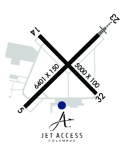
| Lat: N 3915.7 Long: W 08553.8 Elev: 656 Var: +03 Longest Runway: 6401 | ||
| Clr Del: 134.85 TW CLD AWOS: 119.75 Ground: 121.6 Tower: 118.6 | ||
| |||||||||||||||||||||||||||||||||||||||||||||||||||||||||||||||||||||
| |||||||||||||||||||||||||||||||||||||||||||||||||||||||||||||||||||||
| |||||||||||||||||||||||||||||||||||||||||||||||||||||||||||||||||||||
| |||||||||||||||||||||||||||||||||||||||||||||||||||||||||||||||||||||
| Rwy | Rwy | |||||||
| 6401x150 | 6401' | 6401x150 | 6401' | 110.70 - 228° | ||||
| 5000x100 | 5000' | 5000x100 | 5000' | |||||
| Runway ID | Single Wheel | Double Wheel | Double Tandem Wheel | Dual Double Wheel |
| 05/23 | 75,000 | 130,000 | 200,000 | N/A |
| 14/32 | 120,000 | 171,000 | 290,000 | 735,000 |
| These numbers are Advisory and are not limits. The Airport Manager should have more accurate Weight Limits | ||||
 Airport Diagram might not be current. | |
| Facility Name: | COLUMBUS MUNI |
| City Name: | COLUMBUS |
| County: | BARTHOLOMEW |
| State abbrev: | IN |
| State Name: | INDIANA |
| Ownership: | PUBLICLY OWNED |
| Use: | OPEN TO THE PUBLIC |
| Owner's Name: | CITY OF COLUMBUS |
| Address: | 4770 RAY BOLL BLVD |
| COLUMBUS, IN 47203 | |
| Owner's Phone: | 812-376-2519 |
| Manager's Name: | BRIAN PAYNE |
| Address: | 4770 RAY BOLL BLVD |
| COLUMBUS, IN 47203 | |
| Phone: | 812-376-2519; 812-379-9942 |
| FAA Region: | GREAT LAKES |
| FAA Field Office: | CHI |
| Date | Sunrise | Sunset |
|---|---|---|
| 09/24/21 Friday | 7:33 | 19:38 |
| 09/25/21 Saturday | 7:34 | 19:36 |
| 09/26/21 Sunday | 7:35 | 19:35 |
| 09/27/21 Monday | 7:36 | 19:33 |
| 09/28/21 Tuesday | 7:37 | 19:31 |
| 09/29/21 Wednesday | 7:37 | 19:30 |
| 09/30/21 Thursday | 7:38 | 19:28 |
| 10/01/21 Friday | 7:39 | 19:27 |
| 10/02/21 Saturday | 7:40 | 19:25 |
| 10/03/21 Sunday | 7:41 | 19:23 |
| 10/04/21 Monday | 7:42 | 19:22 |
| 10/05/21 Tuesday | 7:43 | 19:20 |
| 10/06/21 Wednesday | 7:44 | 19:19 |
| 10/07/21 Thursday | 7:45 | 19:17 |
| Airport Attendance Schedule | 7 Days A Week 0600-2000; AFT HR - 812-372-1819. |
| Airport Status | OPERATIONAL (This Status can change at any time - please check NOTAMS) |
| Airport Lighting Schedule | WHEN ATCT CLSD ACTVT MALSR RWY 23; REIL RWY 05, 14 & 32; HIRL RWY 05/23; MIRL RWY 14/32 - CTAF. PAPI RWY 5, 14, 23 & 32 ON CONSLY. |
| Airport Storage Available | Tie Downs, Hanger |
| Extra Services Available | Air Freight, Avionics, Charter, Flight Instruction, Aircraft Rental, Aircraft Sales, Annual Surveying |
| Wind Indicator | YES - (lighted) |
| Control Tower | YES |
| CTAF Frequency | 118.600 |
| Unicom Frequency | 122.950 |
| Rotating Beacon Color | CLEAR-GREEN (Light Land Airport) |
| Segmented Circle | NO |
| Landing Fee | NO |
| Airport Inspected | FEDERAL - performed by FAA AIRPORTS FIELD PERSONNEL |
| Inspection Date | 04/10/2019 |
| Type of Fuel Available | Grade 100LL, JET A (freeze point -40C) |
| Airframe Repair Service | MAJOR |
| Power Plant Repair Service | MAJOR |
| Latitude | N3915.7 |
| Longitude | W08553.8 (ESTIMATED) |
| Arpt Elevation | 656ft (SURVEYED) |
| Magnetic Variation | 03W |
| 3 miles N | of COLUMBUS |
| Traffic Pattern Altitude | |
| Sectional Chart | ST LOUIS |
| Operations (Reported) | Yearly | Avg. Daily |
|---|---|---|
| General Aviation Transient | 20157 | 55 |
| General Aviation Local | 19291 | 53 |
| Air Taxi | 336 | 1 |
| Commerical | 0 | 0 |
| Commuter | 0 | 0 |
| Military | 2464 | 7 |
| Aircraft based on Field | |
|---|---|
| General Aviation Singles | 50 |
| General Aviation Multi | 12 |
| Jet Aircraft | 5 |
| General Aviation Helicopters | 3 |
| Military Aircraft | 0 |
| Gliders | 0 |
| Ultralights | 0 |
| FSS on field | NO |
| FSS tie-in | TERRE HAUTE |
| FSS Phone | 1-800-WX-BRIEF |
| Who issues Notams | BAK |
| Notam D service at airport | YES |
| ARTCC Name | INDIANAPOLIS |
| Airport Certification | CLSD TO SKED ACR OPS GTR THAN 9 PAX SEATS. UNSKED ACR OPS GTR THAN 30 PAX SEATS 90 DAY PPR - AMGR OR 379-9942. |
| Aircraft Rescue & Firefighting Index | AIRPORT HAS A CERTIFICATE UNDER CFR PART 139 |
| Airport of Entry | No |
| Custom Landing Rights | No |
| Joint Civil/Military | No |
| Military Landing rights | YES |
| NATIONAL PLAN OF INTEGRATED AIRPORT SYSTEMS (NPIAS) |
| GRANT AGREEMENTS UNDER FAAP/ADAP/AIP |
| SURPLUS PROPERTY AGREEMENT UNDER PUBLIC LAW 289 |
| ASSURANCES PURSUANT TO TITLE VI, CIVIL RIGHTS ACT OF 1964 |
| SAWRS AVBL. |
| BIRDS ON & INVOF ARPT; HVY ACT AUG & SEP. |
| FICONS NOT MNTD 1700-0600. |
| ACFT SVCS - UNICOM. |
| RWY 05/2 3 MIL MARKINGS CMSND. |
Airport Communications & Frequencies:
| |||||||||||||||||||||||
| Runway: 05 | Runway: 23 | ||
| Mag heading: | 48° | Mag heading: | 228° |
| Rwy Slope: | .09% Up | Rwy Slope: | -.09% Down |
| Approach: | Approach: | ILS | |
| Pattern: | Left Traffic | Pattern: | Left Traffic |
| Markings: | PRECISION INSTRUMENT | Markings: | PRECISION INSTRUMENT |
| Marking Condition: | GOOD | Marking Condition: | GOOD |
| Arresting Dev: | Arresting Dev: | ||
| Lat & Long: | N3915.3 W08554.3 | Lat. & Long.: | N3916.1 W08553.3 |
| Elev: | 650.3 ft. MSL | Elev: | 656.0 ft. MSL |
| TCH: | 50 ft. AGL | TCH: | 52 ft. AGL |
| Visual Glide Path: | 3.00 degrees | Visual Glide Path: | 3.00 degrees |
| Displaced Threshold: | No | Displaced Threshold: | No |
| Touchdown Zone: | YES | Touchdown Zone: | YES |
| Touchdown Elev.: | 652.5 feet | Touchdown Elev.: | 656.1 feet |
| Visual Glide Slope: | 4-Light PAPI on LEFT side of Runway | Visual Glide Slope: | 4-Light PAPI on LEFT side of Runway |
| RVR Equipment: | RVR Equipment: | ||
| RVV Equipment: | NO | RVV Equipment: | NO |
| Approach Lights: | Approach Lights: | MALSR - 1,400 foot medium intensity approach lighting system with runway alignment indicator lights | |
| REIL: | YES | REIL: | NO |
| Centerline Lights: | NO | Centerline Lights: | NO |
| Touchdown lights: | NO | Touchdown lights: | NO |
| Runway Category: | Runway with a Non-precision Approach having visibility minimums greater than 3/4 mile | Runway Category: | Precision Instrument Runway |
| Declared Distances: | TORA:6401' TODA:6401' ASDA:6401' LDA:6401' | Declared Distances: | TORA:6401' TODA:6401' ASDA:6401' LDA:6401' |
| Obstructions: | TOWER | Obstructions: | |
| Marked: | NOT Marked/Lighted | Marked: | |
| Clearance slope: | 38:1 | Clearance slope: | 50:1 |
| Obstruction height: | 74 feet AGL | Obstruction height: | |
| Dist. from runway: | 3040 feet | Dist. from runway: | |
| Centerline offset: | 94 right of centerline | Centerline offset: | |
| Comments: | Comments: |
| Runway: 14 | Runway: 32 | ||
| Mag heading: | 138° | Mag heading: | 318° |
| Rwy Slope: | -.06% Down | Rwy Slope: | .06% Up |
| Approach: | Approach: | ||
| Pattern: | Left Traffic | Pattern: | Left Traffic |
| Markings: | NONPRECISION INSTRUMENT | Markings: | NONPRECISION INSTRUMENT |
| Marking Condition: | GOOD | Marking Condition: | GOOD |
| Arresting Dev: | Arresting Dev: | ||
| Lat & Long: | N3916.0 W08554.1 | Lat. & Long.: | N3915.5 W08553.4 |
| Elev: | 654.5 ft. MSL | Elev: | 651.5 ft. MSL |
| TCH: | 45 ft. AGL | TCH: | 45 ft. AGL |
| Visual Glide Path: | 3.00 degrees | Visual Glide Path: | 3.00 degrees |
| Displaced Threshold: | No | Displaced Threshold: | No |
| Touchdown Zone: | YES | Touchdown Zone: | YES |
| Touchdown Elev.: | 654.6 feet | Touchdown Elev.: | 653.2 feet |
| Visual Glide Slope: | 4-Light PAPI on LEFT side of Runway | Visual Glide Slope: | 4-Light PAPI on LEFT side of Runway |
| RVR Equipment: | RVR Equipment: | ||
| RVV Equipment: | NO | RVV Equipment: | NO |
| Approach Lights: | Approach Lights: | ||
| REIL: | YES | REIL: | YES |
| Centerline Lights: | NO | Centerline Lights: | NO |
| Touchdown lights: | NO | Touchdown lights: | NO |
| Runway Category: | Runway with a Non-precision Approach having visibility minimums greater than 3/4 mile | Runway Category: | Runway with a Non-precision Approach having visibility minimums greater than 3/4 mile |
| Declared Distances: | TORA:5000' TODA:5000' ASDA:5000' LDA:5000' | Declared Distances: | TORA:5000' TODA:5000' ASDA:5000' LDA:5000' |
Thanks for using FltPlan.com
all rights reserved © 1999-2021 by Flight Plan LLC