
| BARNES MUNI WESTFIELD/SPRINGFIEL MA |
| |
| Lat: N 4209.5 Long: W 07243.0 Elev: 270 Var: +14 Longest Runway: 9000 | ||
| Clr Del: 121.7 TW CLD Dept. ATIS: 127.1 Arr. ATIS: 127.1 AWOS: 127.1 Ground: 121.7 Tower: 125.07 | ||
| ||||||||||||||||||||||||||||||||||||||||||||||||||||||||||||||||||||
| ||||||||||||||||||||||||||||||||||||||||||||||||||||||||||||||||||||
| ||||||||||||||||||||||||||||||||||||||||||||||||||||||||||||||||||||
| ||||||||||||||||||||||||||||||||||||||||||||||||||||||||||||||||||||
| Rwy | Rwy | |||||||
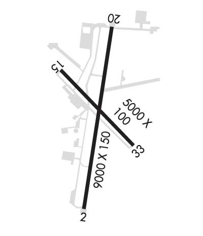
| 9000x150 | 9000' | 9000x150 | 9000' | 111.90 - 204° | ||||
| 5000x75 | 4510' | 5000x75 | 5000' | |||||
| Runway ID | Single Wheel | Double Wheel | Double Tandem Wheel | Dual Double Wheel |
| 02/20 | 75,000 | 160,000 | 240,000 | N/A |
| 15/33 | 51,000 | 60,000 | 155,000 | N/A |
| These numbers are Advisory and are not limits. The Airport Manager should have more accurate Weight Limits | ||||
 Airport Diagram might not be current. | |
| Facility Name: | WESTFIELD-BARNES RGNL |
| City Name: | WESTFIELD/SPRINGFIELD |
| County: | HAMPDEN |
| State abbrev: | MA |
| State Name: | MASSACHUSETTS |
| Ownership: | PUBLICLY OWNED |
| Use: | OPEN TO THE PUBLIC |
| Owner's Name: | CITY OF WESTFIELD |
| Address: | CITY HALL, 59 COURT ST |
| WESTFIELD, MA 01085 | |
| Owner's Phone: | 413-572-6201 |
| Manager's Name: | DANIEL SHEARER |
| Address: | 110 AIRPORT RD |
| WESTFIELD, MA 01085 | |
| Phone: | 413-572-6275 |
| FAA Region: | NEW ENGLAND |
| FAA Field Office: | NONE |
| Date | Sunrise | Sunset |
|---|---|---|
| 06/07/26 Sunday | 5:15 | 20:24 |
| 06/08/26 Monday | 5:15 | 20:25 |
| 06/09/26 Tuesday | 5:15 | 20:26 |
| 06/10/26 Wednesday | 5:14 | 20:26 |
| 06/11/26 Thursday | 5:14 | 20:27 |
| 06/12/26 Friday | 5:14 | 20:27 |
| 06/13/26 Saturday | 5:14 | 20:28 |
| 06/14/26 Sunday | 5:14 | 20:28 |
| 06/15/26 Monday | 5:14 | 20:29 |
| 06/16/26 Tuesday | 5:14 | 20:29 |
| 06/17/26 Wednesday | 5:14 | 20:29 |
| 06/18/26 Thursday | 5:14 | 20:30 |
| 06/19/26 Friday | 5:14 | 20:30 |
| 06/20/26 Saturday | 5:15 | 20:30 |
| Airport Attendance Schedule | 7 Days A Week 0700-1900 LOCAL; FUEL AVBL 0700-1900; SVC AFT 1900 PPR - 413-485-0078. |
| Airport Status | OPERATIONAL (This Status can change at any time - please check NOTAMS) |
| Airport Lighting Schedule | WHEN ATCT CLSD ACTVT MALSR RWY 20; REIL RWY 02; PAPI RWY 15; HIRL RWY 02/20; MIRL RWY 15/33 - CTAF. PAPI RWY 33 - CONSLY. |
| Airport Storage Available | Tie Downs, Hanger |
| Extra Services Available | Air Freight, Charter, Flight Instruction, Aircraft Rental, Aircraft Sales |
| Wind Indicator | YES - (lighted) |
| Control Tower | YES |
| CTAF Frequency | 125.075 |
| Unicom Frequency | |
| Rotating Beacon Color | WG |
| Segmented Circle | YES |
| Landing Fee | YES; FEE FOR COML; CORPORATE; ACFT OVR 7500 LBS. |
| Airport Inspected | FEDERAL - performed by FAA AIRPORTS FIELD PERSONNEL |
| Inspection Date | 06/05/2025 |
| Type of Fuel Available | Grade 100LL, JET A (freeze point -40C) |
| Airframe Repair Service | MAJOR |
| Power Plant Repair Service | MAJOR |
| Latitude | N4209.5 |
| Longitude | W07243.0 (ESTIMATED) |
| Arpt Elevation | 270ft (SURVEYED) |
| Magnetic Variation | 14W |
| 3 miles N | of WESTFIELD/SPRINGFIELD |
| Traffic Pattern Altitude | 1029; TPA 1300 (1029) LGT ACFT; 1800 (1529) HVY & MIL ACFT. EXPC MIL OVHD & CLSD PAT TFC. |
| Sectional Chart | NEW YORK |
| Operations (Reported) | Yearly | Avg. Daily |
|---|---|---|
| General Aviation Transient | 0 | 0 |
| General Aviation Local | 0 | 0 |
| Air Taxi | 0 | 0 |
| Commerical | 0 | 0 |
| Commuter | 0 | 0 |
| Military | 0 | 0 |
| Aircraft based on Field | |
|---|---|
| General Aviation Singles | 0 |
| General Aviation Multi | 0 |
| Jet Aircraft | 0 |
| General Aviation Helicopters | 0 |
| Military Aircraft | 0 |
| Gliders | 0 |
| Ultralights | 0 |
| FSS on field | NO |
| FSS tie-in | BURLINGTON |
| FSS Phone | 1-800-WX-BRIEF |
| Who issues Notams | BAF |
| Notam D service at airport | YES |
| ARTCC Name | BOSTON |
| Airport Certification | PPR 24 HR FOR ACR OPS WITH MORE THAN 9 PAX - AMGR. |
| Aircraft Rescue & Firefighting Index | AIRPORT HAS A CERTIFICATE UNDER CFR PART 139 |
| Airport of Entry | No |
| Custom Landing Rights | YES |
| Joint Civil/Military | No |
| Military Landing rights | YES |
| NATIONAL PLAN OF INTEGRATED AIRPORT SYSTEMS (NPIAS) |
| GRANT AGREEMENTS UNDER FAAP/ADAP/AIP |
| ASSURANCES PURSUANT TO TITLE VI, CIVIL RIGHTS ACT OF 1964 |
| AGREEMENT UNDER DLAND OR DCLA HAS EXPIRED. |
| JET ACFT STARTING UNITS AVBL. |
| CSTMS/AG/IMG - 1300-2300Z++ MON-FRI, FONE PRIOR 2300Z++ PRECEDING WKD C413-785-0365, C800-973-2867. |
| MISC - FIRST 400 FT RWY 02/20 CONC, MID 8200 FT ASPH. RWY 02/20 GROOVED. CLASS D ASP EFF 1200-0300Z++, OT CLASS G. LDG FEE COML, CORPORATE AND ALL ACFT OVER 5000 LB. FLT NOTIFICATION SVC, ADCUS, AVBL. LAWRS. |
| BE AWARE WING TIP CLRNC S RUNUP/D-ARM PAD TWY CNTRLN MKGS FOR F-15 A/C ONLY. |
| SERVICE-A-GEAR: REQ THRU TWR DUR TWR OPR HR, WHEN TWR CLSD REQ THRU ANG CP, WHIP ON UHF 309.0. RWY 02/20, MIL ACFT ARST BARRIERS MAY FAIL IN THE UP POSN. VERIFY STATUS OF BARRIERS PRIOR TO LDG. HVY ACFT SHOULD AVOID LDG DRCTLY ON ARST BARRIER. RWY GROOVING FOR SFC DRAINAGE WI 10 FT N & S OF BOTH ARST SYSS. |
| MILITARY: ANG: NO ACFT WITH WINGSPAN GREATER THAN 110 FT ALLOWED ON ANG RAMP. NSTD TXL CNTRLN MRKG LEADING INTO ANG APN. |
| RWY 2/20 MIL ACFT ARST BARRIERS MAY FAIL IN THE UP PSN. SML GA ACFT SHOULD USE CTN, SPCLY AT NGT, AND IF POSS CFM THE ACTUAL STS OF THE BARRIERS PRIOR TO LDG. |
| COLD TEMPERATURE AIRPORT. ALTITUDE CORRECTION REQUIRED AT OR BELOW -20C. |
| MILITARY: ANG: BASH II COND JUL & AUG FOR MIGRATORY BIRD ACT. |
| FOR CD WHEN ATCT CLSD, CTC BRADLEY APCH AT 860-386-3597. |
| SVR DOWNDRAFT AER 33 WHEN WIND NW IN EXCESS OF 15 KT. BIRDS & OTHER WILDLIFE ON & INVOF ARPT. |
| TWY G CLSD TO CIV OPS. |
| ACFT & HEL NOISE ABATEMENT PROCS IN EFCT - AMGR. |
| MILITARY: ANG: OPR 1200-2200Z++ TUE-FRI EXC HOL. LTD COPTER MAINT, FUEL AND ACFT PRK ARNG RAMP. NO COPTER LDG OR DEP FR PRK RAMP. CTC DSN 698-1811 OR C413-568-9151 EXTN 1811. |
| MILITARY: ANG: ALL TRAN ACFT MUST OBTAIN PPR NR 48 HR PRIOR; CTC C413-568-9151 EXTN 698-1228/9 OR DSN 698-1228/9. OFFL BUS 1230-2200Z++ TUE-FRI, CLSD HOL. NO DE-ICING AVBL. FOR CURRENT BIRD WATCH COND CTC HAWK OPS 309.0; DURG NON-DUTY HR CTC WHIP ON 309.0. BASH PHASE II COND, JUL, AUG AND SEP FOR MIGRATORY BIRD ACT. |
| RWY 15/3 3 RWY 15/33 NOT AVBL FOR PART 121/PART 380 OPS WITH SKED PAX CARRYING OPS MORE THAN 9 PAX SEATS AND NON-SKED PAX CARRYING OPS MORE THAN 30 PAX SEATS. |
| RWY 02/2 0 200 FT OVRN NE END & SW END. |
| RWY 02/2 0 PCR VALUE: 460/R/C/W/T |
| RWY 15/3 3 PCR VALUE: 600/F/A/X/T |
Airport Communications & Frequencies:
| |||||||||||||||||||||||||||||||||||
| Runway: 02 | Runway: 20 | ||
| Mag heading: | 24° | Mag heading: | 204° |
| Rwy Slope: | .07% Up | Rwy Slope: | -.07% Down |
| Approach: | Approach: | ILS | |
| Pattern: | Left Traffic | Pattern: | Left Traffic |
| Markings: | PRECISION INSTRUMENT | Markings: | PRECISION INSTRUMENT |
| Marking Condition: | GOOD | Marking Condition: | GOOD |
| Arresting Dev: | BAK-14; BAK-14 BAK-12B(B) (1420 FT). | Arresting Dev: | BAK-14; BAK-14 BAK-12B(B) (1450 FT). |
| Lat & Long: | N4208.7 W07243.1 | Lat. & Long.: | N4210.2 W07242.8 |
| Elev: | 260.4 ft. MSL | Elev: | 266.5 ft. MSL |
| TCH: | 50 ft. AGL | TCH: | 50 ft. AGL |
| Visual Glide Path: | 3.00 degrees | Visual Glide Path: | 3.00 degrees |
| Displaced Threshold: | No | Displaced Threshold: | No |
| Touchdown Zone: | YES | Touchdown Zone: | YES |
| Touchdown Elev.: | 263.9 feet | Touchdown Elev.: | 270.0 feet |
| Visual Glide Slope: | 4-Light PAPI on LEFT side of Runway | Visual Glide Slope: | 4-Light PAPI on LEFT side of Runway |
| RVR Equipment: | RVR Equipment: | TOUCHDOWN | |
| RVV Equipment: | NO | RVV Equipment: | NO |
| Approach Lights: | Approach Lights: | MALSR - 1,400 foot medium intensity approach lighting system with runway alignment indicator lights | |
| REIL: | YES | REIL: | NO |
| Centerline Lights: | NO | Centerline Lights: | NO |
| Touchdown lights: | NO | Touchdown lights: | NO |
| Runway Category: | Runway with a Non-precision Approach having visibility minimums greater than 3/4 mile | Runway Category: | Precision Instrument Runway |
| Declared Distances: | TORA:9000' TODA:9000' ASDA:9000' LDA:9000' | Declared Distances: | TORA:9000' TODA:9000' ASDA:8919' LDA:8919' |
| Obstructions: | TREES | Obstructions: | TREES |
| Marked: | NOT Marked/Lighted | Marked: | NOT Marked/Lighted |
| Clearance slope: | 20:1 | Clearance slope: | 33:1 |
| Obstruction height: | 56 feet AGL | Obstruction height: | 83 feet AGL |
| Dist. from runway: | 1325 feet | Dist. from runway: | 2950 feet |
| Centerline offset: | 300 right of centerline | Centerline offset: | 175 feet right of centerline |
| Comments: | Comments: |
| Runway: 15 | Runway: 33 | ||
| Mag heading: | 154° | Mag heading: | 334° |
| Rwy Slope: | -.29% Down | Rwy Slope: | .29% Up |
| Approach: | Approach: | ||
| Pattern: | Left Traffic | Pattern: | Left Traffic |
| Markings: | BASIC | Markings: | BASIC |
| Marking Condition: | GOOD | Marking Condition: | GOOD |
| Arresting Dev: | Arresting Dev: | ||
| Lat & Long: | N4209.8 W07243.3 | Lat. & Long.: | N4209.2 W07242.6 |
| Elev: | 261.5 ft. MSL | Elev: | 246.9 ft. MSL |
| TCH: | 41 ft. AGL | TCH: | 42 ft. AGL |
| Visual Glide Path: | 3.50 degrees | Visual Glide Path: | 4.00 degrees |
| Displaced Threshold: | 490 feet | Displaced Threshold: | No |
| Touchdown Zone: | YES | Touchdown Zone: | YES |
| Touchdown Elev.: | 266.2 feet | Touchdown Elev.: | 265.0 feet |
| Visual Glide Slope: | 4-Light PAPI on LEFT side of Runway; UNUSBL BYD 4 NM. | Visual Glide Slope: | 4-Light PAPI on LEFT side of Runway |
| RVR Equipment: | RVR Equipment: | ||
| RVV Equipment: | NO | RVV Equipment: | NO |
| Approach Lights: | Approach Lights: | ||
| REIL: | YES | REIL: | NO |
| Centerline Lights: | NO | Centerline Lights: | NO |
| Touchdown lights: | NO | Touchdown lights: | NO |
| Runway Category: | Runway with a Visual Approach | Runway Category: | Runway with a Visual Approach |
| Declared Distances: | TORA:5000' TODA:5000' ASDA:4508' LDA:4510' | Declared Distances: | TORA:5000' TODA:5000' ASDA:5000' LDA:5000' |
| Obstructions: | TREES | Obstructions: | TREES |
| Marked: | NOT Marked/Lighted | Marked: | NOT Marked/Lighted |
| Clearance slope: | 19:1 | Clearance slope: | 1:1 |
| Obstruction height: | 48 feet AGL | Obstruction height: | 30 feet AGL |
| Dist. from runway: | 1150 feet | Dist. from runway: | 150 feet |
| Centerline offset: | 35 left of centerline | Centerline offset: | |
| Comments: | Comments: |
Thanks for using FltPlan.com
all rights reserved © 1999-2026 by Flight Plan LLC


