
| BEALE AFB (PVT) MARYSVILLE CA |
| |
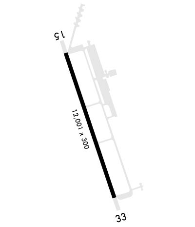
| Lat: N 3908.2 Long: W 12126.2 Elev: 113 Var: -16 Longest Runway: 12001 | ||
| Dept. ATIS: 124.55 Arr. ATIS: 124.55 Ground: 121.6 Tower: 119.4 | ||
| ||||||||||||||||||||||||||||||||
| ||||||||||||||||||||||||||||||||
| Rwy | Rwy | |||||||
| 12001x300 | 12001' | 109.50 - 145° | 12001x300 | 12001' | 109.50 - 325° | |||
| Runway ID | Single Wheel | Double Wheel | Double Tandem Wheel | Dual Double Wheel |
| 15/33 | N/A | N/A | N/A | N/A |
| These numbers are Advisory and are not limits. The Airport Manager should have more accurate Weight Limits | ||||
 Airport Diagram might not be current. | |
| Facility Name: | BEALE AFB |
| City Name: | MARYSVILLE |
| County: | YUBA |
| State abbrev: | CA |
| State Name: | CALIFORNIA |
| Ownership: | AIR FORCE OWNED |
| Use: | PRIVATE |
| Owner's Name: | USAF |
| Address: | BEALE AFB |
| MARYSVILLE, CA 95903 | |
| Owner's Phone: | |
| Manager's Name: | BASE OPERATIONS (USAF) |
| Address: | 9TH CBAT SUP GP (SAC) BEALE AFB |
| MARYSVILLE, CA 95903 | |
| Phone: | 530-634-4823 |
| FAA Region: | WESTERN-PACIFIC |
| FAA Field Office: | SFO |
| Date | Sunrise | Sunset |
|---|---|---|
| 06/08/26 Monday | 5:40 | 20:30 |
| 06/09/26 Tuesday | 5:39 | 20:31 |
| 06/10/26 Wednesday | 5:39 | 20:31 |
| 06/11/26 Thursday | 5:39 | 20:32 |
| 06/12/26 Friday | 5:39 | 20:32 |
| 06/13/26 Saturday | 5:39 | 20:33 |
| 06/14/26 Sunday | 5:39 | 20:33 |
| 06/15/26 Monday | 5:39 | 20:33 |
| 06/16/26 Tuesday | 5:39 | 20:34 |
| 06/17/26 Wednesday | 5:39 | 20:34 |
| 06/18/26 Thursday | 5:39 | 20:34 |
| 06/19/26 Friday | 5:39 | 20:35 |
| 06/20/26 Saturday | 5:40 | 20:35 |
| 06/21/26 Sunday | 5:40 | 20:35 |
| Airport Attendance Schedule | ALL; OPR H24 FR 1400Z++ MON THRU 0600Z++ SAT (2200L FRI), AND/OR BY NOTAM; CLSD WKEND AND HOL, OPENING AT 1400Z++ THE NEXT DUTY DAY. |
| Airport Status | OPERATIONAL (This Status can change at any time - please check NOTAMS) |
| Airport Lighting Schedule | SS-SR |
| Airport Storage Available | Hanger |
| Extra Services Available | Cargo Handling |
| Wind Indicator | YES - (unlit) |
| Control Tower | YES |
| CTAF Frequency | |
| Unicom Frequency | |
| Rotating Beacon Color | SWG |
| Segmented Circle | NO |
| Landing Fee | NO |
| Airport Inspected | No Inspection Data Available performed by the OWNER |
| Inspection Date | Unknown |
| Type of Fuel Available | None |
| Airframe Repair Service | MINOR |
| Power Plant Repair Service | MINOR |
| Latitude | N3908.2 |
| Longitude | W12126.2 (ESTIMATED) |
| Arpt Elevation | 112ft (SURVEYED) |
| Magnetic Variation | 16E |
| 6 miles E | of MARYSVILLE |
| Traffic Pattern Altitude | TFC PAT: RECTANGULAR PAT 1100 FT; OVHD PAT 2100 FT. FTR TYPE ACFT FLY RP RWY 15. |
| Sectional Chart | SAN FRANCISCO |
| Operations (Reported) | Yearly | Avg. Daily |
|---|---|---|
| General Aviation Transient | 0 | 0 |
| General Aviation Local | 0 | 0 |
| Air Taxi | 0 | 0 |
| Commerical | 0 | 0 |
| Commuter | 0 | 0 |
| Military | 0 | 0 |
| Aircraft based on Field | |
|---|---|
| General Aviation Singles | 0 |
| General Aviation Multi | 0 |
| Jet Aircraft | 0 |
| General Aviation Helicopters | 0 |
| Military Aircraft | 0 |
| Gliders | 0 |
| Ultralights | 0 |
| FSS on field | NO |
| FSS tie-in | RANCHO MURIETA |
| FSS Phone | 1-800-WX-BRIEF |
| Who issues Notams | BAB |
| Notam D service at airport | YES |
| ARTCC Name | OAKLAND |
| Airport Certification | |
| Aircraft Rescue & Firefighting Index | None |
| Airport of Entry | No |
| Custom Landing Rights | YES |
| Joint Civil/Military | No |
| Military Landing rights | No |
| BEARING STRENGTH RWY 15/33: S160 T300 ST175 ST175 SBTT620 TT490 TDT840. |
| CSTMS/AG/IMG: 24 HR PN RQR FOR CSTMS AND AG. |
| MISC: TRAN ACFT EXP PROGRESSIVE TAXI. NO COMSEC MATERIAL AVBL. TRAN AIRCREW SHOULD PLAN TO ARR WITH APPROPRIATE COMSEC TO COMPLETE ENTIRE MSN. RWY 15-33 GROOVED. CLASS C AIRSPACE CONT. |
| RWY LGTS: RY 15, SF. |
| CAUTION: BEALE AFB IS LCTD ON A MAJ MIGRATORY BIRD FLYWAY. |
| BEARING STRENGTH RWY 15/33: S81, T122, ST175, SBTT590, TT490, TDT840. |
| PMSV METRO: WX OBSN AVBL H24 VIA AUTO OBSN SYS; WX SVC AVBL 1 HR PRIOR TO AFLD OPR HRS AND DUR FCST SEVERE WX DSN 368-9134, C530-634-9134. DUR WX FLT CLOSURES REMOTE BRIEFING SVC AVBL FROM 25 OP WX SQ DSN 228-6598/6599/6588. |
| JASU: (AM32A-60A) (A/M32A-86) 7(MC-1A) (MC-2A). |
| PMSV METRO: WHEN AUTO OBSN SYS INOP, OBST FR 325-060 DEG, 080-220 DEG, AND 245-280 DEG MAY IMPACT PREVAILING VIS. |
| CAUTION: USE EXTREME CAUTION FOR UNMANNED ACFT ACT IN VCNTY OF BEALE AFB. |
| CSTMS/AG/IMG: LTD CSTMS/AG AVBL TO MIL ACFT ONLY, 24 HR PN RQR. CTC AFLD MGT AT C530-634-2002 OR DSN 368-2002. |
| ATIS: OPR WHEN AERODROME IS OPEN. |
| FOR CD WHEN ATCT IS CLSD CTC NORCAL APCH AT 916-361-6874 |
| MISC: NO SPACE-A PAX SUPPORT AVBL ON WKENDS, HOL, AND ACC FAMILY DAYS. |
| RSTD: VIP PRKG RSTD TO ACFT WITH WINGSPAN 85 FT OR LESS. LRGR DV ACFT WILL PARK ON CARGO SPOTS. |
| MISC: WX SVC AVBL H24. CURRENT WX OBSN AVBL VIA ATIS OR CTC ATC. |
| FUEL: J8. |
| SVC TRAN ALERT: LAV CART AVBL FOR TSNT ACFT WITH PRIOR CDN. AIRCREW WILL HAVE TO PERFORM THEIR OWN LAV SVC AND CLEANUP. |
| SVC TRAN ALERT: NO POTABLE WATER OR ICE SVC. |
| AFRC: 940TH COMD POST, DSN 368-1960, C530-634-1960. |
| MISC: FOR SUPPORT OUTSIDE OF AIRFIELD OPR HRS (I.E., WKENDS, WING DOWN DAYS AND HOL) CTC BEALE 9RW COMMAND POST, DSN 368-5700, C530-634-5700. |
| MISC: STORAGE OF CLASSIFIED MTRL UNAVBL AT AIRFIELD MGMT; CTC COMMAND POST DSN 368-5700, C530-634-5700, H24 PRIOR. |
| FLUID: W SP LPOX LOX. |
| RWYLGTS: RY 33, SF. |
| OIL: O-128-133-148. |
| TRAN ALERT: SVC AVBL 1500-0600Z++ MON-FRI EXC FEDERAL HOL. ACFT THAT ARR AFTER 0600Z++ WILL NOT BE SVCD UNTIL NEXT DUTY DAY. FLEET SVC AVBL, 24 HR PN. |
| RSTD: PPR 24 HR PN, CTC BASE OPS DSN 368-2002/9120, C530-634-2002/9120. ISSUED PPR VALID 1 HR +/- ETA, EARLY/LATE ARR/DEP MUST RE-COORD. |
| RSTD: NO UNANNOUNCED ACFT PRACTICE APCH. INBOUND TSNT ACFT OBTAIN APVL FROM CTL TWR DSN 368-9140 FOR ACFT PRACTICE APCH PRIOR TO FLT. LTD PRKG AVBL. |
| RWY 15/3 3 RWY 300 FT WIDE MARKED AT 200 FT; FULL 300 FT WIDTH USBL. |
Airport Communications & Frequencies:
| |||||||||||||||||||||||||||||||||
| Runway: 15 | Runway: 33 | ||
| Mag heading: | 145° | Mag heading: | 325° |
| Rwy Slope: | -.06% Down | Rwy Slope: | .06% Up |
| Approach: | LOC/GS | Approach: | LOC/GS |
| Pattern: | Left Traffic | Pattern: | Left Traffic |
| Markings: | PRECISION INSTRUMENT | Markings: | PRECISION INSTRUMENT |
| Marking Condition: | GOOD | Marking Condition: | GOOD |
| Arresting Dev: | Arresting Dev: | ||
| Lat & Long: | N3909.1 W12126.6 | Lat. & Long.: | N3907.2 W12125.8 |
| Elev: | 112.7 ft. MSL | Elev: | 105.1 ft. MSL |
| TCH: | 54 ft. AGL | TCH: | 51 ft. AGL |
| Visual Glide Path: | 2.75 degrees | Visual Glide Path: | 3.00 degrees |
| Displaced Threshold: | No | Displaced Threshold: | No |
| Touchdown Zone: | YES | Touchdown Zone: | YES |
| Touchdown Elev.: | 112.7 feet | Touchdown Elev.: | 105.1 feet |
| Visual Glide Slope: | 4-Light PAPI on LEFT side of Runway | Visual Glide Slope: | 4-Light PAPI on LEFT side of Runway |
| RVR Equipment: | TOUCHDOWN | RVR Equipment: | TOUCHDOWN |
| RVV Equipment: | NO | RVV Equipment: | NO |
| Approach Lights: | ALSF1 - standard 2,400 foot high intensity approach lighting system with sequenced flashers, Category I | Approach Lights: | ALSF1 - standard 2,400 foot high intensity approach lighting system with sequenced flashers, Category I |
| REIL: | NO | REIL: | NO |
| Centerline Lights: | NO | Centerline Lights: | NO |
| Touchdown lights: | NO | Touchdown lights: | NO |
| Runway Category: | Runway Category: | ||
| Declared Distances: | Declared Distances: |
Thanks for using FltPlan.com
all rights reserved © 1999-2026 by Flight Plan LLC
