
| SUGARLOAF RGNL CARRABASSETT ME |
| |
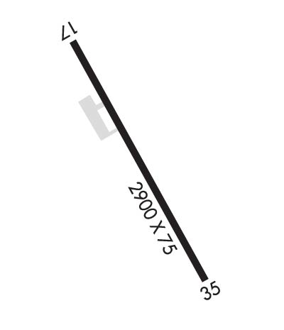
| Lat: N 4505.1 Long: W 07013.0 Elev: 880 Var: +17 Longest Runway: 2797 | ||
| CTAF: 122.8 | ||
| ||||||||||||||||||||||||||||||||
| ||||||||||||||||||||||||||||||||
| Rwy | Rwy | |||||||
| 2797x75 | 2797' | 2797x75 | 2708' | |||||
| Runway ID | Single Wheel | Double Wheel | Double Tandem Wheel | Dual Double Wheel |
| 17/35 | 12,000 | N/A | N/A | N/A |
| These numbers are Advisory and are not limits. The Airport Manager should have more accurate Weight Limits | ||||
 Airport Diagram might not be current. | |
| Facility Name: | SUGARLOAF RGNL |
| City Name: | CARRABASSETT |
| County: | FRANKLIN |
| State abbrev: | ME |
| State Name: | MAINE |
| Ownership: | PUBLICLY OWNED |
| Use: | OPEN TO THE PUBLIC |
| Owner's Name: | TOWN OF CARRABASSETT |
| Address: | 1001 CARRIAGE RD |
| CARRABASSETT VALLEY, ME 04947 | |
| Owner's Phone: | 207-235-2646 |
| Manager's Name: | TOM WALLACE; ADDNL CTC: TOM WALLACE AT TLWCFII@YAHOO.COM. |
| Address: | 1001 CARRIAGE RD |
| CARRABASSETT VALLEY, ME 04947 | |
| Phone: | 207-350-1415 |
| FAA Region: | NEW ENGLAND |
| FAA Field Office: | NONE |
| Date | Sunrise | Sunset |
|---|---|---|
| 06/08/26 Monday | 4:54 | 20:26 |
| 06/09/26 Tuesday | 4:54 | 20:26 |
| 06/10/26 Wednesday | 4:54 | 20:27 |
| 06/11/26 Thursday | 4:53 | 20:28 |
| 06/12/26 Friday | 4:53 | 20:28 |
| 06/13/26 Saturday | 4:53 | 20:29 |
| 06/14/26 Sunday | 4:53 | 20:29 |
| 06/15/26 Monday | 4:53 | 20:30 |
| 06/16/26 Tuesday | 4:53 | 20:30 |
| 06/17/26 Wednesday | 4:53 | 20:30 |
| 06/18/26 Thursday | 4:53 | 20:31 |
| 06/19/26 Friday | 4:53 | 20:31 |
| 06/20/26 Saturday | 4:53 | 20:31 |
| 06/21/26 Sunday | 4:54 | 20:32 |
| Airport Attendance Schedule | UNATTENDED |
| Airport Status | OPERATIONAL (This Status can change at any time - please check NOTAMS) |
| Airport Lighting Schedule | |
| Airport Storage Available | Tie Downs |
| Extra Services Available | NONE |
| Wind Indicator | YES - (unlit) |
| Control Tower | NO |
| CTAF Frequency | 122.800 |
| Unicom Frequency | 122.800 |
| Rotating Beacon Color | |
| Segmented Circle | YES |
| Landing Fee | NO |
| Airport Inspected | STATE - performed by PRIVATE CONTRACT PERSONNEL |
| Inspection Date | 08/09/2025 |
| Type of Fuel Available | Grade 100LLMOGAS |
| Airframe Repair Service | NONE |
| Power Plant Repair Service | NONE |
| Latitude | N4505.1 |
| Longitude | W07013.0 (ESTIMATED) |
| Arpt Elevation | 880ft (SURVEYED) |
| Magnetic Variation | 17W |
| 1 miles N | of CARRABASSETT |
| Traffic Pattern Altitude | 2000 |
| Sectional Chart | MONTREAL |
| Operations (Reported) | Yearly | Avg. Daily |
|---|---|---|
| General Aviation Transient | 0 | 0 |
| General Aviation Local | 0 | 0 |
| Air Taxi | 0 | 0 |
| Commerical | 0 | 0 |
| Commuter | 0 | 0 |
| Military | 0 | 0 |
| Aircraft based on Field | |
|---|---|
| General Aviation Singles | 0 |
| General Aviation Multi | 0 |
| Jet Aircraft | 0 |
| General Aviation Helicopters | 0 |
| Military Aircraft | 0 |
| Gliders | 0 |
| Ultralights | 0 |
| FSS on field | NO |
| FSS tie-in | BANGOR |
| FSS Phone | 1-800-WX-BRIEF |
| Who issues Notams | BGR |
| Notam D service at airport | YES |
| ARTCC Name | BOSTON |
| Airport Certification | |
| Aircraft Rescue & Firefighting Index | None |
| Airport of Entry | No |
| Custom Landing Rights | No |
| Joint Civil/Military | No |
| Military Landing rights | YES |
| NATIONAL PLAN OF INTEGRATED AIRPORT SYSTEMS (NPIAS) |
| GRANT AGREEMENTS UNDER FAAP/ADAP/AIP |
| ASSURANCES PURSUANT TO TITLE VI, CIVIL RIGHTS ACT OF 1964 |
| HIGH TRRN 4237 FT MSL NORTH/EAST/WEST OF ARPT. |
| CALL 207-350-1415 TO CK ARPT CONDS. |
| DEER, MOOSE & TURKEY ON & INVOF ARPT. |
| FOR CD CTC BOSTON ARTCC AT 603-879-6859. |
Airport Communications & Frequencies:
| |||||||||
| Runway: 17 | Runway: 35 | ||
| Mag heading: | 166° | Mag heading: | 346° |
| Rwy Slope: | -.83% Down | Rwy Slope: | .83% Up |
| Approach: | Approach: | ||
| Pattern: | Left Traffic | Pattern: | Left Traffic |
| Markings: | BASIC | Markings: | BASIC |
| Marking Condition: | GOOD | Marking Condition: | GOOD |
| Arresting Dev: | Arresting Dev: | ||
| Lat & Long: | N4505.3 W07013.1 | Lat. & Long.: | N4504.9 W07012.8 |
| Elev: | 880.0 ft. MSL | Elev: | 856.9 ft. MSL |
| TCH: | TCH: | ||
| Visual Glide Path: | Visual Glide Path: | ||
| Displaced Threshold: | No | Displaced Threshold: | 89 feet |
| Touchdown Zone: | YES | Touchdown Zone: | YES |
| Touchdown Elev.: | 880.0 feet | Touchdown Elev.: | 880.0 feet |
| Visual Glide Slope: | Visual Glide Slope: | ||
| RVR Equipment: | RVR Equipment: | ||
| RVV Equipment: | NO | RVV Equipment: | NO |
| Approach Lights: | Approach Lights: | ||
| REIL: | NO | REIL: | NO |
| Centerline Lights: | NO | Centerline Lights: | NO |
| Touchdown lights: | NO | Touchdown lights: | NO |
| Runway Category: | Runway with a Visual Approach | Runway Category: | Runway with a Visual Approach |
| Declared Distances: | Declared Distances: | ||
| Obstructions: | ROAD | Obstructions: | BLDG |
| Marked: | NOT Marked/Lighted | Marked: | NOT Marked/Lighted |
| Clearance slope: | Clearance slope: | 2:1 | |
| Obstruction height: | 10 feet AGL | Obstruction height: | 53 feet AGL |
| Dist. from runway: | 200 feet | Dist. from runway: | 316 feet |
| Centerline offset: | 85 left of centerline | Centerline offset: | 160 feet right of centerline |
| Comments: | +10 FT ROADWAY 100-200 FT FM THR, 85-125 FT L OF CNTRLN. | Comments: |
Thanks for using FltPlan.com
all rights reserved © 1999-2026 by Flight Plan LLC
