
| WHITFORDS WEEDSPORT NY |
| |
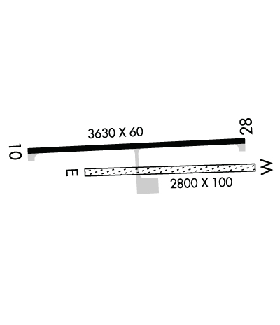
| Lat: N 4304.8 Long: W 07632.3 Elev: 400 Var: +12 Longest Runway: 3630 | ||
| CTAF: 122.8 | ||
| ||||||
|
| Rwy | Rwy | |||||||
| 3630x60 | 3200' | 3630x60 | 3280' | |||||
| 2800x100 | 2800' | 2800x100 | 2800' | |||||
| Runway ID | Single Wheel | Double Wheel | Double Tandem Wheel | Dual Double Wheel |
| 10/28 | N/A | N/A | N/A | N/A |
| E/W | N/A | N/A | N/A | N/A |
| These numbers are Advisory and are not limits. The Airport Manager should have more accurate Weight Limits | ||||
 Airport Diagram might not be current. | |
| Facility Name: | WHITFORDS |
| City Name: | WEEDSPORT |
| County: | CAYUGA |
| State abbrev: | NY |
| State Name: | NEW YORK |
| Ownership: | PRIVATELY OWNED |
| Use: | OPEN TO THE PUBLIC |
| Owner's Name: | JOHN WHITFORD |
| Address: | 3043 DITMAR ROAD |
| WEEDSPORT, NY 13166 | |
| Owner's Phone: | 315-834-9950 |
| Manager's Name: | JOHN WHITFORD |
| Address: | 3043 DITMAR ROAD |
| WEEDSPORT, NY 13166 | |
| Phone: | 315-834-9950 |
| FAA Region: | EASTERN |
| FAA Field Office: | NYC |
| Date | Sunrise | Sunset |
|---|---|---|
| 09/24/21 Friday | 6:55 | 19:00 |
| 09/25/21 Saturday | 6:56 | 18:59 |
| 09/26/21 Sunday | 6:58 | 18:57 |
| 09/27/21 Monday | 6:59 | 18:55 |
| 09/28/21 Tuesday | 7:00 | 18:53 |
| 09/29/21 Wednesday | 7:01 | 18:51 |
| 09/30/21 Thursday | 7:02 | 18:50 |
| 10/01/21 Friday | 7:03 | 18:48 |
| 10/02/21 Saturday | 7:04 | 18:46 |
| 10/03/21 Sunday | 7:05 | 18:44 |
| 10/04/21 Monday | 7:07 | 18:43 |
| 10/05/21 Tuesday | 7:08 | 18:41 |
| 10/06/21 Wednesday | 7:09 | 18:39 |
| 10/07/21 Thursday | 7:10 | 18:37 |
| Airport Attendance Schedule | 7 Days A Week DALGT |
| Airport Status | OPERATIONAL (This Status can change at any time - please check NOTAMS) |
| Airport Lighting Schedule | ACTVT MIRL RWY 10/28 - 122.7.; DUSK-2300. FOR ROTG BCN AFTER 2300 CALL 315-834-9950. |
| Airport Storage Available | Tie Downs |
| Extra Services Available | Flight Instruction, Parachute Jumping, Aircraft Rental |
| Wind Indicator | YES - (lighted) |
| Control Tower | NO |
| CTAF Frequency | 122.800 |
| Unicom Frequency | 122.800 |
| Rotating Beacon Color | CLEAR-GREEN (Light Land Airport); BEACON OTS INDEFLY. |
| Segmented Circle | YES |
| Landing Fee | NO |
| Airport Inspected | 5010-1 PUBLIC USE MAILOUT PROGRAM - performed by STATE AERONAUTICAL PERSONNEL |
| Inspection Date | 06/15/2018 |
| Type of Fuel Available | Grade 100LLMOGAS; -10 91 OCTANE NO-ETHANOL AVBL. |
| Airframe Repair Service | NONE |
| Power Plant Repair Service | NONE |
| Latitude | N4304.8 |
| Longitude | W07632.3 (ESTIMATED) |
| Arpt Elevation | 400ft (SURVEYED) |
| Magnetic Variation | 12W |
| 2 miles NE | of WEEDSPORT |
| Traffic Pattern Altitude | 800 |
| Sectional Chart | NEW YORK |
| Operations (Reported) | Yearly | Avg. Daily |
|---|---|---|
| General Aviation Transient | 2000 | 5 |
| General Aviation Local | 4000 | 11 |
| Air Taxi | 0 | 0 |
| Commerical | 0 | 0 |
| Commuter | 0 | 0 |
| Military | 100 | 0 |
| Aircraft based on Field | |
|---|---|
| General Aviation Singles | 18 |
| General Aviation Multi | 1 |
| Jet Aircraft | 0 |
| General Aviation Helicopters | 0 |
| Military Aircraft | 0 |
| Gliders | 0 |
| Ultralights | 0 |
| FSS on field | NO |
| FSS tie-in | BUFFALO |
| FSS Phone | 1-800-WX-BRIEF |
| Who issues Notams | BUF |
| Notam D service at airport | YES |
| ARTCC Name | BOSTON |
| Airport Certification | |
| Aircraft Rescue & Firefighting Index | None |
| Airport of Entry | No |
| Custom Landing Rights | No |
| Joint Civil/Military | No |
| Military Landing rights | No |
| NATIONAL PLAN OF INTEGRATED AIRPORT SYSTEMS (NPIAS) |
| RWY E/W CLSD NOV 1 - MAY 15. |
| ULTRA-LIGHTS ON & INVOF ARPT. |
| SKYDIVING ON & INVOF ARPT. |
| FOR CD CTC SYRACUSE APCH AT 315-455-6218. |
Airport Communications & Frequencies:
| ||||||||||||||
| Runway: 10 | Runway: 28 | ||
| Mag heading: | 99° | Mag heading: | 279° |
| Rwy Slope: | .00% | Rwy Slope: | .00% |
| Approach: | Approach: | ||
| Pattern: | Left Traffic | Pattern: | Left Traffic |
| Markings: | NONPRECISION INSTRUMENT | Markings: | NONPRECISION INSTRUMENT |
| Marking Condition: | GOOD | Marking Condition: | GOOD |
| Arresting Dev: | Arresting Dev: | ||
| Lat & Long: | N4304.8 W07632.8 | Lat. & Long.: | N4304.9 W07632.0 |
| Elev: | 398.0 ft. MSL | Elev: | 398.0 ft. MSL |
| TCH: | TCH: | ||
| Visual Glide Path: | Visual Glide Path: | ||
| Displaced Threshold: | 430 feet | Displaced Threshold: | 350 feet |
| Touchdown Zone: | YES | Touchdown Zone: | YES |
| Touchdown Elev.: | 400.0 feet | Touchdown Elev.: | 400.0 feet |
| Visual Glide Slope: | Visual Glide Slope: | ||
| RVR Equipment: | RVR Equipment: | ||
| RVV Equipment: | NO | RVV Equipment: | NO |
| Approach Lights: | Approach Lights: | ||
| REIL: | NO | REIL: | NO |
| Centerline Lights: | NO | Centerline Lights: | NO |
| Touchdown lights: | NO | Touchdown lights: | NO |
| Runway Category: | Runway with a Non-precision Approach having visibility minimums greater than 3/4 mile | Runway Category: | Runway with a Non-precision Approach having visibility minimums greater than 3/4 mile |
| Declared Distances: | Declared Distances: | ||
| Obstructions: | TREES | Obstructions: | TREES |
| Marked: | NOT Marked/Lighted | Marked: | NOT Marked/Lighted |
| Clearance slope: | 2:1 | Clearance slope: | 1:1 |
| Obstruction height: | 50 feet AGL | Obstruction height: | 67 feet AGL |
| Dist. from runway: | 315 feet | Dist. from runway: | 347 feet |
| Centerline offset: | 191 left of centerline | Centerline offset: | 203 feet right of centerline |
| Comments: | Comments: |
| Runway: E | Runway: W | ||
| Mag heading: | 278° | Mag heading: | 98° |
| Rwy Slope: | .00% | Rwy Slope: | .00% |
| Approach: | Approach: | ||
| Pattern: | Left Traffic | Pattern: | Left Traffic |
| Markings: | Markings: | ||
| Marking Condition: | Marking Condition: | ||
| Arresting Dev: | Arresting Dev: | ||
| Lat & Long: | N4304.8 W07632.5 | Lat. & Long.: | N4304.8 W07631.9 |
| Elev: | 393.0 ft. MSL | Elev: | 393.0 ft. MSL |
| TCH: | TCH: | ||
| Visual Glide Path: | Visual Glide Path: | ||
| Displaced Threshold: | No | Displaced Threshold: | No |
| Touchdown Zone: | YES | Touchdown Zone: | YES |
| Touchdown Elev.: | 393.0 feet | Touchdown Elev.: | 393.0 feet |
| Visual Glide Slope: | Visual Glide Slope: | ||
| RVR Equipment: | RVR Equipment: | ||
| RVV Equipment: | NO | RVV Equipment: | NO |
| Approach Lights: | Approach Lights: | ||
| REIL: | NO | REIL: | NO |
| Centerline Lights: | NO | Centerline Lights: | NO |
| Touchdown lights: | NO | Touchdown lights: | NO |
| Runway Category: | Runway with a Visual Approach | Runway Category: | Runway with a Visual Approach |
| Declared Distances: | Declared Distances: | ||
| Obstructions: | HILL | Obstructions: | TREES |
| Marked: | NOT Marked/Lighted | Marked: | NOT Marked/Lighted |
| Clearance slope: | 14:1 | Clearance slope: | |
| Obstruction height: | 12 feet AGL | Obstruction height: | 60 feet AGL |
| Dist. from runway: | 173 feet | Dist. from runway: | 7 feet |
| Centerline offset: | 130 right of centerline | Centerline offset: | 98 feet left of centerline |
| Comments: | Comments: |
Thanks for using FltPlan.com
all rights reserved © 1999-2021 by Flight Plan LLC
