
| PALO ALTO ARPT OF SANTA CLARA PALO ALTO CA |
| |
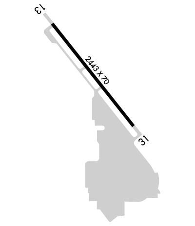
| Lat: N 3727.7 Long: W 12206.9 Elev: 7 Var: -15 Longest Runway: 2443 | ||
| Dept. ATIS: 135.27 Arr. ATIS: 135.27 Ground: 125.0 Tower: 118.6 | ||
| |||||||||||||||||||||||||||||||||||||||||||||||||||||||||||||
| |||||||||||||||||||||||||||||||||||||||||||||||||||||||||||||
| |||||||||||||||||||||||||||||||||||||||||||||||||||||||||||||
| |||||||||||||||||||||||||||||||||||||||||||||||||||||||||||||
| |||||||||||||||||||||||||||||||||||||||||||||||||||||||||||||
| Rwy | Rwy | |||||||
| 2443x70 | 2443' | 2443x70 | 2443' | |||||
| Runway ID | Single Wheel | Double Wheel | Double Tandem Wheel | Dual Double Wheel |
| 13/31 | 12,500 | N/A | N/A | N/A |
| These numbers are Advisory and are not limits. The Airport Manager should have more accurate Weight Limits | ||||
 Airport Diagram might not be current. | |
| Facility Name: | PALO ALTO |
| City Name: | PALO ALTO |
| County: | SANTA CLARA |
| State abbrev: | CA |
| State Name: | CALIFORNIA |
| Ownership: | PUBLICLY OWNED |
| Use: | OPEN TO THE PUBLIC |
| Owner's Name: | CITY OF PALO ALTO |
| Address: | 250 HAMILTON AVENUE |
| PALO ALTO, CA 94301-2531 | |
| Owner's Phone: | (650) 329-2444 |
| Manager's Name: | ANDREW SWANSON |
| Address: | 250 HAMILTON AVENUE |
| PALO ALTO, CA 94301-2531 | |
| Phone: | (650) 329-2444 |
| FAA Region: | WESTERN-PACIFIC |
| FAA Field Office: | SFO |
| Date | Sunrise | Sunset |
|---|---|---|
| 04/18/24 Thursday | 6:28 | 19:47 |
| 04/19/24 Friday | 6:27 | 19:48 |
| 04/20/24 Saturday | 6:26 | 19:49 |
| 04/21/24 Sunday | 6:24 | 19:50 |
| 04/22/24 Monday | 6:23 | 19:51 |
| 04/23/24 Tuesday | 6:22 | 19:52 |
| 04/24/24 Wednesday | 6:21 | 19:53 |
| 04/25/24 Thursday | 6:19 | 19:54 |
| 04/26/24 Friday | 6:18 | 19:55 |
| 04/27/24 Saturday | 6:17 | 19:56 |
| 04/28/24 Sunday | 6:16 | 19:56 |
| 04/29/24 Monday | 6:15 | 19:57 |
| 04/30/24 Tuesday | 6:13 | 19:58 |
| 05/01/24 Wednesday | 6:12 | 19:59 |
| Airport Attendance Schedule | 7 Days A Week 0600-2000 |
| Airport Status | OPERATIONAL (This Status can change at any time - please check NOTAMS) |
| Airport Lighting Schedule | ARPT LGTS OPERATE CONTINUOUSLY WHEN ATCT CLSD. |
| Airport Storage Available | Tie Downs |
| Extra Services Available | Air Ambulance, Avionics, Charter, Glider, Flight Instruction, Aircraft Rental, Aircraft Sales |
| Wind Indicator | YES - (lighted) |
| Control Tower | YES |
| CTAF Frequency | 118.600 |
| Unicom Frequency | 122.950 |
| Rotating Beacon Color | WG |
| Segmented Circle | YES |
| Landing Fee | NO |
| Airport Inspected | STATE - performed by STATE AERONAUTICAL PERSONNEL |
| Inspection Date | 12/15/2023 |
| Type of Fuel Available | Grade 100LL, JET A (freeze point -40C); -10SELF-FUELING AVAILBLE 24/7. |
| Airframe Repair Service | MAJOR |
| Power Plant Repair Service | MAJOR |
| Latitude | N3727.7 |
| Longitude | W12206.9 (ESTIMATED) |
| Arpt Elevation | 6ft (SURVEYED) |
| Magnetic Variation | 15E |
| 0 miles E | of PALO ALTO |
| Traffic Pattern Altitude | |
| Sectional Chart | SAN FRANCISCO |
| Operations (Reported) | Yearly | Avg. Daily |
|---|---|---|
| General Aviation Transient | 76509 | 210 |
| General Aviation Local | 115083 | 315 |
| Air Taxi | 105 | 0 |
| Commerical | 0 | 0 |
| Commuter | 0 | 0 |
| Military | 0 | 0 |
| Aircraft based on Field | |
|---|---|
| General Aviation Singles | 311 |
| General Aviation Multi | 18 |
| Jet Aircraft | 0 |
| General Aviation Helicopters | 1 |
| Military Aircraft | 0 |
| Gliders | 1 |
| Ultralights | 0 |
| FSS on field | NO |
| FSS tie-in | OAKLAND |
| FSS Phone | 1-800-WX-BRIEF |
| Who issues Notams | PAO |
| Notam D service at airport | YES |
| ARTCC Name | OAKLAND |
| Airport Certification | |
| Aircraft Rescue & Firefighting Index | None |
| Airport of Entry | No |
| Custom Landing Rights | No |
| Joint Civil/Military | No |
| Military Landing rights | YES |
| NATIONAL PLAN OF INTEGRATED AIRPORT SYSTEMS (NPIAS) |
| GRANT AGREEMENTS UNDER FAAP/ADAP/AIP |
| ASSURANCES PURSUANT TO TITLE VI, CIVIL RIGHTS ACT OF 1964 |
| THIS AIRPORT HAS BEEN SURVEYED BY THE NATIONAL GEODETIC SURVEY. |
| +100 FT TRANSMISSION TWRS E OF ARPT. |
| ARPT RSTRD BY ARPT OPR TO ACFT WITH MAX CERTD WT OF 12500 LBS OR LESS. |
| FOR CD WHEN ATCT IS CLSD CTC NORCAL APCH AT 916-361-3748. |
| BIRDS ON AND INVOF AP. |
| TPA 1000 FT W & 800 FT E. |
| NOISE SENSITIVE AREA SE THRU NW OF ARPT. RCMD ACFT LDG AT PALO ALTO ARPT FLY AT OR ABOVE 1500 FT UNTIL XNG THE BAYSHORE FREEWAY, AND RCMD ACFT DEP RWY 31 TURN 10 DEG RIGHT AFTER TKOF TIL RCHG DUMBARTON AUTO BRIDGE. |
| BE ALERT FOR PEDESTRAINS XNG A DIKE ROAD 8 FT HIGH AND 300 FT FROM RWY 13 END. |
| CONS PEDESTRIAN/VEHICLE ACT ON ACFT TAXI LANES NOT DESIGNATED AS TWY MOV AREAS. |
| ARPT SCTY PRODS IN EFCT. |
| ON APCH TO RWY 31 BE ALERT TO POSS STG UPDRAFT FM WIND TUNNEL LCTD ON W SIDE OF MOFFETT FEDERAL AIRFIELD. |
Airport Communications & Frequencies:
| |||||||||||||||||||||||||||||||
| Runway: 13 | Runway: 31 | ||
| Mag heading: | 127° | Mag heading: | 307° |
| Rwy Slope: | .00% Up | Rwy Slope: | .00% Down |
| Approach: | Approach: | ||
| Pattern: | Left Traffic | Pattern: | Right Traffic |
| Markings: | BASIC | Markings: | NONPRECISION INSTRUMENT |
| Marking Condition: | GOOD | Marking Condition: | GOOD |
| Arresting Dev: | Arresting Dev: | ||
| Lat & Long: | N3727.8 W12207.1 | Lat. & Long.: | N3727.5 W12206.7 |
| Elev: | 6.7 ft. MSL | Elev: | 6.8 ft. MSL |
| TCH: | 29 ft. AGL | TCH: | 29 ft. AGL |
| Visual Glide Path: | 4.00 degrees | Visual Glide Path: | 4.00 degrees |
| Displaced Threshold: | No | Displaced Threshold: | No |
| Touchdown Zone: | YES | Touchdown Zone: | YES |
| Touchdown Elev.: | 6.8 feet | Touchdown Elev.: | 6.8 feet |
| Visual Glide Slope: | 2-Light PAPI on LEFT side of Runway | Visual Glide Slope: | 2-Light PAPI on LEFT side of Runway |
| RVR Equipment: | RVR Equipment: | ||
| RVV Equipment: | NO | RVV Equipment: | NO |
| Approach Lights: | Approach Lights: | ||
| REIL: | YES | REIL: | YES |
| Centerline Lights: | NO | Centerline Lights: | NO |
| Touchdown lights: | NO | Touchdown lights: | NO |
| Runway Category: | Runway with a Visual Approach | Runway Category: | Runway with a Non-precision Approach |
| Declared Distances: | Declared Distances: | ||
| Obstructions: | BERM | Obstructions: | BERM |
| Marked: | LIGHTED | Marked: | LIGHTED |
| Clearance slope: | 12:1; RY 13 +8 FT DIKE 300 FT FROM RY END, OBSTN LGTD. | Clearance slope: | 6:1; RY 31 +5 FT DIKE 230 FT FROM RY END, OBSTN LGTD. |
| Obstruction height: | 8 feet AGL | Obstruction height: | 5 feet AGL |
| Dist. from runway: | 300 feet | Dist. from runway: | 230 feet |
| Centerline offset: | Centerline offset: | ||
| Comments: | Comments: |
Thanks for using FltPlan.com
all rights reserved © 1999-2024 by Flight Plan LLC

