| KALAMAZOO/BATTLE CREEK INTL KALAMAZOO MI |
| |
| Lat: N 4214.1 Long: W 08533.1 Elev: 874 Var: +03 Longest Runway: 6502 | ||
| Clr Del: 121.75 Dept. ATIS: 127.25 Arr. ATIS: 127.25 AWOS: 127.25 Ground: 121.9 Tower: 118.3 | ||
| |||||||||||||||||||||||||||||||||||||||
| |||||||||||||||||||||||||||||||||||||||
| |||||||||||||||||||||||||||||||||||||||
| |||||||||||||||||||||||||||||||||||||||
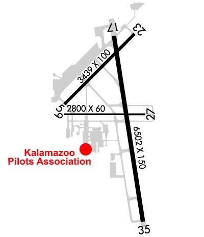
| Rwy | Rwy | |||||||
| 3438x100 | 3438' | 3438x100 | 3438' | |||||
| 2800x60 | 2800' | 2800x60 | 2800' | |||||
| 6502x150 | 6502' | 6502x150 | 6502' | 110.90 - 354° | ||||
| Runway ID | Single Wheel | Double Wheel | Double Tandem Wheel | Dual Double Wheel |
| 05/23 | 30,000 | 45,000 | 60,000 | N/A |
| 09/27 | 30,000 | 60,000 | N/A | N/A |
| 17/35 | 85,000 | 121,000 | 240,000 | N/A |
| These numbers are Advisory and are not limits. The Airport Manager should have more accurate Weight Limits | ||||
 Airport Diagram might not be current. | |
| Facility Name: | KALAMAZOO/BATTLE CREEK INTL |
| City Name: | KALAMAZOO |
| County: | KALAMAZOO |
| State abbrev: | MI |
| State Name: | MICHIGAN |
| Ownership: | PUBLICLY OWNED |
| Use: | OPEN TO THE PUBLIC |
| Owner's Name: | KALAMAZOO CO |
| Address: | 5235 PORTAGE RD |
| PORTAGE, MI 49002 | |
| Owner's Phone: | 269-388-3668 |
| Manager's Name: | CRAIG WILLIAMS, AIRPORT DIRECTOR |
| Address: | 5235 PORTAGE RD |
| PORTAGE, MI 49002 | |
| Phone: | 269-388-3668 |
| FAA Region: | GREAT LAKES |
| FAA Field Office: | DET |
| Date | Sunrise | Sunset |
|---|---|---|
| 06/07/26 Sunday | 6:06 | 21:16 |
| 06/08/26 Monday | 6:06 | 21:17 |
| 06/09/26 Tuesday | 6:06 | 21:17 |
| 06/10/26 Wednesday | 6:06 | 21:18 |
| 06/11/26 Thursday | 6:05 | 21:18 |
| 06/12/26 Friday | 6:05 | 21:19 |
| 06/13/26 Saturday | 6:05 | 21:19 |
| 06/14/26 Sunday | 6:05 | 21:20 |
| 06/15/26 Monday | 6:05 | 21:20 |
| 06/16/26 Tuesday | 6:05 | 21:21 |
| 06/17/26 Wednesday | 6:05 | 21:21 |
| 06/18/26 Thursday | 6:05 | 21:21 |
| 06/19/26 Friday | 6:05 | 21:22 |
| 06/20/26 Saturday | 6:06 | 21:22 |
| Airport Attendance Schedule | CONTINUOUS |
| Airport Status | OPERATIONAL (This Status can change at any time - please check NOTAMS) |
| Airport Lighting Schedule | WHEN ATCT CLSD ACTVT MALSR RWY 35; REIL RWY 17, 05, & 23; HIRL RWY 17/35; MIRL RWY 05/23 & 09/27 - CTAF. PAPI RWY 17, 35, 05, & 23 OPR CONSLY.; ATC-CTL |
| Airport Storage Available | Tie Downs, Hanger |
| Extra Services Available | Cargo Handling, Charter, Flight Instruction, Aircraft Rental |
| Wind Indicator | YES - (lighted) |
| Control Tower | YES |
| CTAF Frequency | 118.300 |
| Unicom Frequency | 122.950 |
| Rotating Beacon Color | WG |
| Segmented Circle | YES |
| Landing Fee | YES; GA LDG FEE FOR ACFT WITH MAX LDG WT 8000 LB OR GTR. |
| Airport Inspected | FEDERAL - performed by FAA AIRPORTS FIELD PERSONNEL |
| Inspection Date | 05/08/2024 |
| Type of Fuel Available | Grade 100LL, JET A (freeze point -40C) |
| Airframe Repair Service | MAJOR |
| Power Plant Repair Service | MAJOR |
| Latitude | N4214.1 |
| Longitude | W08533.1 (ESTIMATED) |
| Arpt Elevation | 873ft (SURVEYED) |
| Magnetic Variation | 03W |
| 3 miles SE | of KALAMAZOO |
| Traffic Pattern Altitude | 800 |
| Sectional Chart | CHICAGO |
| Operations (Reported) | Yearly | Avg. Daily |
|---|---|---|
| General Aviation Transient | 0 | 0 |
| General Aviation Local | 0 | 0 |
| Air Taxi | 0 | 0 |
| Commerical | 0 | 0 |
| Commuter | 0 | 0 |
| Military | 0 | 0 |
| Aircraft based on Field | |
|---|---|
| General Aviation Singles | 0 |
| General Aviation Multi | 0 |
| Jet Aircraft | 0 |
| General Aviation Helicopters | 0 |
| Military Aircraft | 0 |
| Gliders | 0 |
| Ultralights | 0 |
| FSS on field | NO |
| FSS tie-in | LANSING |
| FSS Phone | 1-800-WX-BRIEF |
| Who issues Notams | AZO |
| Notam D service at airport | YES |
| ARTCC Name | CHICAGO |
| Airport Certification | AIRPORT RECEIVING SCHEDULED AIR CARRIER SERVICE FROM CARRIERS CERTIFICATED BY THE CIVIL AERONAUTICS BOARD; PPR FOR UNSKED ACR OPS GTR THAN 30 PAX SEATS - CALL AMGR. |
| Aircraft Rescue & Firefighting Index | AIRPORT HAS A CERTIFICATE UNDER CFR PART 139 |
| Airport of Entry | No |
| Custom Landing Rights | YES |
| Joint Civil/Military | No |
| Military Landing rights | YES |
| NATIONAL PLAN OF INTEGRATED AIRPORT SYSTEMS (NPIAS) |
| GRANT AGREEMENTS UNDER FAAP/ADAP/AIP |
| ASSURANCES PURSUANT TO TITLE VI, CIVIL RIGHTS ACT OF 1964 |
| AGREEMENT UNDER DLAND OR DCLA HAS EXPIRED. |
| MIGRATORY WATER FOWL ROOSTING AREA 5500 FT APCH END RY 35. BIRDS ON & INVOF ARPT. |
| 11C SPB LCTD 3.6 NM SOUTH. ACFT OPRG AT 11C WILL ANNC INTNS ON AZO CTAF. |
| PPR FOR UNSKED ACR OPS GTR THAN 175,000 LB MAX TOG. |
| FICONS UNMON NOV-APR 0000-0300 & MAY-OCT 0000-0400. |
| FOR CUSTOMS CALL 269-965-3349. |
| TWYS F & G E OF RY 17/35 RSTRD ACFT LESS THAN 12500 LBS. |
| RY 09 & RY 05 APCH ENDS ARE CLOSELY ALIGNED. VERIFY CORRECT RY AND COMPASS HEADING PRIOR TO DEP. |
| FOR CD WHEN TWR CLSD CTC GREAT LAKES APCH AT 269-459-3344, WHEN APCH CLSD CTC CHICAGO ARTCC AT 630-906-8921. |
| RWY 05/2 3 RWY 05/23 NOT AVBL FOR PART 121/PART 380 OPS WITH SKED PAX CARRYING OPS MORE THAN 9 PAX SEATS AND NON-SKED PAX CARRYING OPS MORE THAN 30 PAX SEATS. NO PART 121/PART 380 OPS EXC FOR TAX. |
| RWY 09/2 7 RWY 09/27 NOT AVBL FOR PART 121/PART 380 OPS WITH SKED PAX CARRYING OPS MORE THAN 9 PAX SEATS AND NON-SKED PAX CARRYING OPS MORE THAN 30 PAX SEATS. |
| RWY 05/2 3 PCR VALUE: 354/F/C/X/T |
| RWY 09/2 7 PCR VALUE: 66/F/C/X/T |
| RWY 17/3 5 PCR VALUE: 402/F/C/X/T |
Airport Communications & Frequencies:
| |||||||||||||||||||||||||||||||||||||||||||||
| Runway: 05 | Runway: 23 | ||
| Mag heading: | 48° | Mag heading: | 228° |
| Rwy Slope: | -.67% Down | Rwy Slope: | .67% Up |
| Approach: | Approach: | ||
| Pattern: | Left Traffic | Pattern: | Left Traffic |
| Markings: | NONPRECISION INSTRUMENT | Markings: | NONPRECISION INSTRUMENT |
| Marking Condition: | FAIR | Marking Condition: | FAIR |
| Arresting Dev: | Arresting Dev: | ||
| Lat & Long: | N4214.1 W08533.5 | Lat. & Long.: | N4214.5 W08532.9 |
| Elev: | 873.8 ft. MSL | Elev: | 850.9 ft. MSL |
| TCH: | 28 ft. AGL | TCH: | 38 ft. AGL |
| Visual Glide Path: | 3.00 degrees | Visual Glide Path: | 3.50 degrees |
| Displaced Threshold: | No | Displaced Threshold: | No |
| Touchdown Zone: | YES | Touchdown Zone: | YES |
| Touchdown Elev.: | 873.9 feet | Touchdown Elev.: | 873.9 feet |
| Visual Glide Slope: | 4-Light PAPI on LEFT side of Runway | Visual Glide Slope: | 4-Light PAPI on LEFT side of Runway |
| RVR Equipment: | RVR Equipment: | ||
| RVV Equipment: | NO | RVV Equipment: | NO |
| Approach Lights: | Approach Lights: | ||
| REIL: | YES | REIL: | YES |
| Centerline Lights: | NO | Centerline Lights: | NO |
| Touchdown lights: | NO | Touchdown lights: | NO |
| Runway Category: | Runway with a Non-precision Approach having visibility minimums greater than 3/4 mile | Runway Category: | Runway with a Non-precision Approach having visibility minimums greater than 3/4 mile |
| Declared Distances: | TORA:3438' TODA:3438' ASDA:3438' LDA:3438' | Declared Distances: | TORA:3438' TODA:3438' ASDA:3438' LDA:3438' |
| Obstructions: | POLE | Obstructions: | TREE |
| Marked: | NOT Marked/Lighted | Marked: | NOT Marked/Lighted |
| Clearance slope: | 15:1 | Clearance slope: | 16:1 |
| Obstruction height: | 46 feet AGL | Obstruction height: | 53 feet AGL |
| Dist. from runway: | 900 feet | Dist. from runway: | 1050 feet |
| Centerline offset: | 275 right of centerline | Centerline offset: | 340 feet left of centerline |
| Comments: | Comments: |
| Runway: 09 | Runway: 27 | ||
| Mag heading: | 93° | Mag heading: | 273° |
| Rwy Slope: | -.36% Down | Rwy Slope: | .36% Up |
| Approach: | Approach: | ||
| Pattern: | Left Traffic | Pattern: | Left Traffic |
| Markings: | BASIC | Markings: | BASIC |
| Marking Condition: | FAIR | Marking Condition: | FAIR |
| Arresting Dev: | Arresting Dev: | ||
| Lat & Long: | N4214.0 W08533.5 | Lat. & Long.: | N4214.0 W08532.9 |
| Elev: | 872.9 ft. MSL | Elev: | 862.7 ft. MSL |
| TCH: | TCH: | ||
| Visual Glide Path: | Visual Glide Path: | ||
| Displaced Threshold: | No | Displaced Threshold: | No |
| Touchdown Zone: | YES | Touchdown Zone: | YES |
| Touchdown Elev.: | 873.0 feet | Touchdown Elev.: | 873.0 feet |
| Visual Glide Slope: | Visual Glide Slope: | ||
| RVR Equipment: | RVR Equipment: | ||
| RVV Equipment: | NO | RVV Equipment: | NO |
| Approach Lights: | Approach Lights: | ||
| REIL: | NO | REIL: | NO |
| Centerline Lights: | NO | Centerline Lights: | NO |
| Touchdown lights: | NO | Touchdown lights: | NO |
| Runway Category: | Runway with a Visual Approach | Runway Category: | Runway with a Visual Approach |
| Declared Distances: | TORA:2800' TODA:2800' ASDA:2800' LDA:2800' | Declared Distances: | TORA:2800' TODA:2800' ASDA:2800' LDA:2800' |
| Obstructions: | TREE | Obstructions: | RR |
| Marked: | NOT Marked/Lighted | Marked: | NOT Marked/Lighted |
| Clearance slope: | 17:1 | Clearance slope: | 25:1 |
| Obstruction height: | 84 feet AGL | Obstruction height: | 17 feet AGL |
| Dist. from runway: | 1710 feet | Dist. from runway: | 640 feet |
| Centerline offset: | 275 left of centerline | Centerline offset: | |
| Comments: | Comments: |
| Runway: 17 | Runway: 35 | ||
| Mag heading: | 174° | Mag heading: | 354° |
| Rwy Slope: | .14% Up | Rwy Slope: | -.14% Down |
| Approach: | Approach: | ILS | |
| Pattern: | Left Traffic | Pattern: | Left Traffic |
| Markings: | PRECISION INSTRUMENT | Markings: | PRECISION INSTRUMENT |
| Marking Condition: | GOOD | Marking Condition: | GOOD |
| Arresting Dev: | Arresting Dev: | ||
| Lat & Long: | N4214.5 W08533.1 | Lat. & Long.: | N4213.4 W08532.9 |
| Elev: | 859.2 ft. MSL | Elev: | 868.2 ft. MSL |
| TCH: | 45 ft. AGL | TCH: | 53 ft. AGL |
| Visual Glide Path: | 3.00 degrees | Visual Glide Path: | 3.00 degrees |
| Displaced Threshold: | No | Displaced Threshold: | No |
| Touchdown Zone: | YES | Touchdown Zone: | YES |
| Touchdown Elev.: | 866.9 feet | Touchdown Elev.: | 868.4 feet |
| Visual Glide Slope: | 4-Light PAPI on LEFT side of Runway | Visual Glide Slope: | 4-Light PAPI on LEFT side of Runway |
| RVR Equipment: | ROLLOUT | RVR Equipment: | TOUCHDOWN |
| RVV Equipment: | NO | RVV Equipment: | NO |
| Approach Lights: | Approach Lights: | MALSR - 1,400 foot medium intensity approach lighting system with runway alignment indicator lights | |
| REIL: | YES | REIL: | NO |
| Centerline Lights: | NO | Centerline Lights: | NO |
| Touchdown lights: | NO | Touchdown lights: | NO |
| Runway Category: | Runway with a Non-precision Approach having visibility minimums greater than 3/4 mile | Runway Category: | Precision Instrument Runway |
| Declared Distances: | TORA:6502' TODA:6502' ASDA:6502' LDA:6502' | Declared Distances: | TORA:6502' TODA:6502' ASDA:6502' LDA:6502' |
| Obstructions: | TREES | Obstructions: | RR |
| Marked: | NOT Marked/Lighted | Marked: | NOT Marked/Lighted |
| Clearance slope: | 24:1 | Clearance slope: | 31:1 |
| Obstruction height: | 76 feet AGL | Obstruction height: | 18 feet AGL |
| Dist. from runway: | 2090 feet | Dist. from runway: | 758 feet |
| Centerline offset: | 750 left of centerline | Centerline offset: | 586 feet right of centerline |
| Comments: | Comments: |
Thanks for using FltPlan.com
all rights reserved © 1999-2026 by Flight Plan LLC