| NEIL ARMSTRONG WAPAKONETA OH |
| |
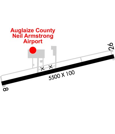
| Lat: N 4029.6 Long: W 08417.9 Elev: 913 Var: +04 Longest Runway: 5500 | ||
| AWOS: 128.32 CTAF: 122.8 | ||
| ||||||||||||||||||||||||||||||||||||||||||||||||||||||||||||||||||||
| ||||||||||||||||||||||||||||||||||||||||||||||||||||||||||||||||||||
| ||||||||||||||||||||||||||||||||||||||||||||||||||||||||||||||||||||
| Rwy | Rwy | |||||||
| 5500x100 | 4800' | 5500x100 | 5263' | 109.15 - 261° | ||||
| Runway ID | Single Wheel | Double Wheel | Double Tandem Wheel | Dual Double Wheel |
| 08/26 | N/A | N/A | N/A | N/A |
| These numbers are Advisory and are not limits. The Airport Manager should have more accurate Weight Limits | ||||
 Airport Diagram might not be current. | |
| Facility Name: | NEIL ARMSTRONG |
| City Name: | WAPAKONETA |
| County: | AUGLAIZE |
| State abbrev: | OH |
| State Name: | OHIO |
| Ownership: | PUBLICLY OWNED |
| Use: | OPEN TO THE PUBLIC |
| Owner's Name: | AUGLAIZE CO ARPT AUTH |
| Address: | PO BOX 400 |
| NEW KNOXVILLE, OH 45871-0400 | |
| Owner's Phone: | 419-753-2810 |
| Manager's Name: | TED BERGSTROM |
| Address: | PO BOX 400 |
| NEW KNOXVILLE, OH 45871-0400 | |
| Phone: | 419-753-2810 |
| FAA Region: | GREAT LAKES |
| FAA Field Office: | DET |
| Date | Sunrise | Sunset |
|---|---|---|
| 09/24/21 Friday | 7:26 | 19:31 |
| 09/25/21 Saturday | 7:27 | 19:30 |
| 09/26/21 Sunday | 7:28 | 19:28 |
| 09/27/21 Monday | 7:29 | 19:26 |
| 09/28/21 Tuesday | 7:30 | 19:25 |
| 09/29/21 Wednesday | 7:31 | 19:23 |
| 09/30/21 Thursday | 7:32 | 19:21 |
| 10/01/21 Friday | 7:33 | 19:20 |
| 10/02/21 Saturday | 7:34 | 19:18 |
| 10/03/21 Sunday | 7:35 | 19:16 |
| 10/04/21 Monday | 7:36 | 19:15 |
| 10/05/21 Tuesday | 7:37 | 19:13 |
| 10/06/21 Wednesday | 7:38 | 19:12 |
| 10/07/21 Thursday | 7:39 | 19:10 |
| Airport Attendance Schedule | MON-FRI 0700-1700, SAT-SUN ON CALL; FOR SVC CALL AMGR. |
| Airport Status | OPERATIONAL (This Status can change at any time - please check NOTAMS) |
| Airport Lighting Schedule | ACTVT REIL RWY 08 & 26; MIRL RWY 08/26 - 122.7. |
| Airport Storage Available | Tie Downs |
| Extra Services Available | Flight Instruction, Aircraft Rental, Aircraft Sales |
| Wind Indicator | YES - (lighted) |
| Control Tower | NO |
| CTAF Frequency | 122.800 |
| Unicom Frequency | 122.800 |
| Rotating Beacon Color | CLEAR-GREEN (Light Land Airport) |
| Segmented Circle | NO |
| Landing Fee | NO |
| Airport Inspected | STATE - performed by STATE AERONAUTICAL PERSONNEL |
| Inspection Date | 05/08/2018 |
| Type of Fuel Available | Grade 100LL, JET A-1 (icing inhibitor, freeze point -50C) |
| Airframe Repair Service | MAJOR |
| Power Plant Repair Service | MAJOR |
| Latitude | N4029.6 |
| Longitude | W08417.9 (ESTIMATED) |
| Arpt Elevation | 912ft (SURVEYED) |
| Magnetic Variation | 04W |
| 8 miles SW | of WAPAKONETA |
| Traffic Pattern Altitude | 990 |
| Sectional Chart | DETROIT |
| Operations (Reported) | Yearly | Avg. Daily |
|---|---|---|
| General Aviation Transient | 3000 | 8 |
| General Aviation Local | 5000 | 14 |
| Air Taxi | 1800 | 5 |
| Commerical | 0 | 0 |
| Commuter | 0 | 0 |
| Military | 5 | 0 |
| Aircraft based on Field | |
|---|---|
| General Aviation Singles | 26 |
| General Aviation Multi | 0 |
| Jet Aircraft | 5 |
| General Aviation Helicopters | 0 |
| Military Aircraft | 0 |
| Gliders | 0 |
| Ultralights | 0 |
| FSS on field | NO |
| FSS tie-in | DAYTON |
| FSS Phone | 1-800-WX-BRIEF |
| Who issues Notams | DAY |
| Notam D service at airport | YES |
| ARTCC Name | INDIANAPOLIS |
| Airport Certification | |
| Aircraft Rescue & Firefighting Index | None |
| Airport of Entry | No |
| Custom Landing Rights | No |
| Joint Civil/Military | No |
| Military Landing rights | No |
| NATIONAL PLAN OF INTEGRATED AIRPORT SYSTEMS (NPIAS) |
| GRANT AGREEMENTS UNDER FAAP/ADAP/AIP |
| ASSURANCES PURSUANT TO TITLE VI, CIVIL RIGHTS ACT OF 1964 |
| THIS AIRPORT HAS BEEN SURVEYED BY THE NATIONAL GEODETIC SURVEY. |
| FOR CD CTC COLUMBUS APCH AT 614-338-8537. |
Airport Communications & Frequencies:
| ||||||||||||||||||
| Runway: 08 | Runway: 26 | ||
| Mag heading: | 81° | Mag heading: | 261° |
| Rwy Slope: | .01% Up | Rwy Slope: | -.01% Down |
| Approach: | Approach: | LOC/DME | |
| Pattern: | Left Traffic | Pattern: | Left Traffic |
| Markings: | NONPRECISION INSTRUMENT | Markings: | NONPRECISION INSTRUMENT |
| Marking Condition: | GOOD | Marking Condition: | GOOD |
| Arresting Dev: | Arresting Dev: | ||
| Lat & Long: | N4029.5 W08418.5 | Lat. & Long.: | N4029.7 W08417.3 |
| Elev: | 907.8 ft. MSL | Elev: | 908.3 ft. MSL |
| TCH: | 50 ft. AGL | TCH: | 40 ft. AGL |
| Visual Glide Path: | 4.00 degrees | Visual Glide Path: | 3.00 degrees |
| Displaced Threshold: | 700 feet | Displaced Threshold: | 237 feet |
| Touchdown Zone: | YES | Touchdown Zone: | YES |
| Touchdown Elev.: | 912.5 feet | Touchdown Elev.: | 909.9 feet |
| Visual Glide Slope: | 4-Light PAPI on LEFT side of Runway | Visual Glide Slope: | 4-Light PAPI on LEFT side of Runway |
| RVR Equipment: | RVR Equipment: | ||
| RVV Equipment: | NO | RVV Equipment: | NO |
| Approach Lights: | Approach Lights: | ||
| REIL: | YES | REIL: | YES |
| Centerline Lights: | NO | Centerline Lights: | NO |
| Touchdown lights: | NO | Touchdown lights: | NO |
| Runway Category: | Runway with a Non-precision Approach | Runway Category: | Runway with a Non-precision Approach |
| Declared Distances: | Declared Distances: | ||
| Obstructions: | TREES | Obstructions: | ROAD |
| Marked: | NOT Marked/Lighted | Marked: | NOT Marked/Lighted |
| Clearance slope: | 2:1; RWY 08 APCH SLOPE 12:1 TO DSPLCD THLD DUE TO +91 FT TREE 1155 FT DISTANCE 270 FT L. | Clearance slope: | 8:1; RY 26 APCH SLOPE 15:1 TO DSPLCD THLD DUE TO +16 FT ROAD 452 FT DSTC 275 FT R. |
| Obstruction height: | 91 feet AGL | Obstruction height: | 15 feet AGL |
| Dist. from runway: | 455 feet | Dist. from runway: | 330 feet |
| Centerline offset: | 270 left of centerline | Centerline offset: | 275 feet right of centerline |
| Comments: | Comments: |
Thanks for using FltPlan.com
all rights reserved © 1999-2021 by Flight Plan LLC