
| HOUSTON-SOUTHWEST HOUSTON TX |
| |
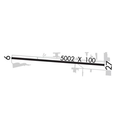
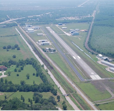
| Lat: N 2930.4 Long: W 09528.6 Elev: 69 Var: -05 Longest Runway: 5002 | ||
| Clr Del: 120.8 AWOS: 123.62 CTAF: 123.0 | ||
| ||||||||||||||||||||||||||||||||||||||||||||
| ||||||||||||||||||||||||||||||||||||||||||||
| ||||||||||||||||||||||||||||||||||||||||||||
| Rwy | Rwy | |||||||
| 5002x100 | 5002' | 108.90 - 089° | 5002x100 | 5002' | ||||
| Runway ID | Single Wheel | Double Wheel | Double Tandem Wheel | Dual Double Wheel |
| 09/27 | 60,000 | 75,000 | 100,000 | N/A |
| These numbers are Advisory and are not limits. The Airport Manager should have more accurate Weight Limits | ||||
 Airport Diagram might not be current. | |
| Facility Name: | HOUSTON/SOUTHWEST |
| City Name: | HOUSTON |
| County: | FORT BEND |
| State abbrev: | TX |
| State Name: | TEXAS |
| Ownership: | PRIVATELY OWNED |
| Use: | OPEN TO THE PUBLIC |
| Owner's Name: | JAMES GRIFFITH JR; WILSON GRIFFITH |
| Address: | 503 MC KEEVER RD |
| ARCOLA, TX 77583 | |
| Owner's Phone: | 281-431-2581 |
| Manager's Name: | LEN FRANKLIN |
| Address: | 503 MC KEEVER RD #1505 |
| ARCOLA, TX 77583 | |
| Phone: | 281-431-2581 |
| FAA Region: | SOUTHWEST |
| FAA Field Office: | TEX |
| Date | Sunrise | Sunset |
|---|---|---|
| 06/07/26 Sunday | 6:21 | 20:20 |
| 06/08/26 Monday | 6:21 | 20:21 |
| 06/09/26 Tuesday | 6:21 | 20:21 |
| 06/10/26 Wednesday | 6:21 | 20:21 |
| 06/11/26 Thursday | 6:21 | 20:22 |
| 06/12/26 Friday | 6:21 | 20:22 |
| 06/13/26 Saturday | 6:21 | 20:23 |
| 06/14/26 Sunday | 6:21 | 20:23 |
| 06/15/26 Monday | 6:22 | 20:23 |
| 06/16/26 Tuesday | 6:22 | 20:24 |
| 06/17/26 Wednesday | 6:22 | 20:24 |
| 06/18/26 Thursday | 6:22 | 20:24 |
| 06/19/26 Friday | 6:22 | 20:24 |
| 06/20/26 Saturday | 6:22 | 20:25 |
| Airport Attendance Schedule | CONTINUOUS |
| Airport Status | OPERATIONAL (This Status can change at any time - please check NOTAMS) |
| Airport Lighting Schedule | MIRL RWY 09/27 PRESET LOW INTST SS-SR. TO INCR INTST & ACTVT REIL RWY 09 & 27- CTAF. |
| Airport Storage Available | Tie Downs, Hanger |
| Extra Services Available | Flight Instruction, Aircraft Rental |
| Wind Indicator | YES - (lighted) |
| Control Tower | NO |
| CTAF Frequency | 123.000 |
| Unicom Frequency | 123.000 |
| Rotating Beacon Color | WG |
| Segmented Circle | NO |
| Landing Fee | NO |
| Airport Inspected | STATE - performed by PRIVATE CONTRACT PERSONNEL |
| Inspection Date | 03/23/2026 |
| Type of Fuel Available | Grade 100LL, JET A |
| Airframe Repair Service | MAJOR |
| Power Plant Repair Service | MAJOR |
| Latitude | N2930.4 |
| Longitude | W09528.6 (ESTIMATED) |
| Arpt Elevation | 68ft (SURVEYED) |
| Magnetic Variation | 05E |
| 15 miles SW | of HOUSTON |
| Traffic Pattern Altitude | |
| Sectional Chart | HOUSTON |
| Operations (Reported) | Yearly | Avg. Daily |
|---|---|---|
| General Aviation Transient | 0 | 0 |
| General Aviation Local | 0 | 0 |
| Air Taxi | 0 | 0 |
| Commerical | 0 | 0 |
| Commuter | 0 | 0 |
| Military | 0 | 0 |
| Aircraft based on Field | |
|---|---|
| General Aviation Singles | 0 |
| General Aviation Multi | 0 |
| Jet Aircraft | 0 |
| General Aviation Helicopters | 0 |
| Military Aircraft | 0 |
| Gliders | 0 |
| Ultralights | 0 |
| FSS on field | NO |
| FSS tie-in | MONTGOMERY COUNTY |
| FSS Phone | 1-800-WX-BRIEF |
| Who issues Notams | CXO |
| Notam D service at airport | YES |
| ARTCC Name | HOUSTON |
| Airport Certification | |
| Aircraft Rescue & Firefighting Index | None |
| Airport of Entry | No |
| Custom Landing Rights | No |
| Joint Civil/Military | No |
| Military Landing rights | No |
| NATIONAL PLAN OF INTEGRATED AIRPORT SYSTEMS (NPIAS) |
| GRANT AGREEMENTS UNDER FAAP/ADAP/AIP |
| HEL TFC INVOF ARPT. |
| FOR CD CTC HOUSTON APCH AT 281-443-5844. TO CNL IFR CTC HOUSTON APCH AT 281-443-5888. |
| RWY 09 CALM WIND RWY. |
Airport Communications & Frequencies:
| ||||||||||||||||
| Runway: 09 | Runway: 27 | ||
| Mag heading: | 89° | Mag heading: | 269° |
| Rwy Slope: | -.05% Down | Rwy Slope: | .05% Up |
| Approach: | LOC/DME | Approach: | |
| Pattern: | Left Traffic | Pattern: | Left Traffic |
| Markings: | NONPRECISION INSTRUMENT | Markings: | NONPRECISION INSTRUMENT |
| Marking Condition: | GOOD | Marking Condition: | GOOD |
| Arresting Dev: | Arresting Dev: | ||
| Lat & Long: | N2930.4 W09529.1 | Lat. & Long.: | N2930.3 W09528.1 |
| Elev: | 68.9 ft. MSL | Elev: | 66.4 ft. MSL |
| TCH: | 50 ft. AGL | TCH: | 43 ft. AGL |
| Visual Glide Path: | 3.50 degrees | Visual Glide Path: | 3.00 degrees |
| Displaced Threshold: | No | Displaced Threshold: | No |
| Touchdown Zone: | YES | Touchdown Zone: | YES |
| Touchdown Elev.: | 68.9 feet | Touchdown Elev.: | 67.5 feet |
| Visual Glide Slope: | 2-Light PAPI on LEFT side of Runway | Visual Glide Slope: | 2-Light PAPI on LEFT side of Runway |
| RVR Equipment: | RVR Equipment: | ||
| RVV Equipment: | NO | RVV Equipment: | NO |
| Approach Lights: | Approach Lights: | ||
| REIL: | YES | REIL: | YES |
| Centerline Lights: | NO | Centerline Lights: | NO |
| Touchdown lights: | NO | Touchdown lights: | NO |
| Runway Category: | Runway with a Non-precision Approach having visibility minimums greater than 3/4 mile | Runway Category: | Runway with a Non-precision Approach having visibility minimums greater than 3/4 mile |
| Declared Distances: | Declared Distances: | ||
| Obstructions: | ROAD | Obstructions: | ROAD |
| Marked: | NOT Marked/Lighted | Marked: | NOT Marked/Lighted |
| Clearance slope: | 4:1 | Clearance slope: | 8:1 |
| Obstruction height: | 15 feet AGL | Obstruction height: | 15 feet AGL |
| Dist. from runway: | 265 feet | Dist. from runway: | 330 feet |
| Centerline offset: | 260 left of centerline | Centerline offset: | |
| Comments: | Comments: |
Thanks for using FltPlan.com
all rights reserved © 1999-2026 by Flight Plan LLC