
| AVON PARK EXECUTIVE AVON PARK FL |
| |
| Lat: N 2735.5 Long: W 08131.7 Elev: 160 Var: +05 Longest Runway: 5374 | ||
| AWOS: 118.72 CTAF: 122.8 | ||
| ||||||||||||||||||||||||||||||||||||||||||||
| ||||||||||||||||||||||||||||||||||||||||||||
| ||||||||||||||||||||||||||||||||||||||||||||
| ||||||||||||||||||||||||||||||||||||||||||||
| Rwy | Rwy | |||||||
| 5374x100 | 5374' | 5374x100 | 4330' | |||||
| 3844x75 | 3844' | 3844x75 | 3844' | |||||
| Runway ID | Single Wheel | Double Wheel | Double Tandem Wheel | Dual Double Wheel |
| 05/23 | 50,000 | 73,000 | N/A | N/A |
| 10/28 | 78,000 | 119,000 | N/A | N/A |
| These numbers are Advisory and are not limits. The Airport Manager should have more accurate Weight Limits | ||||
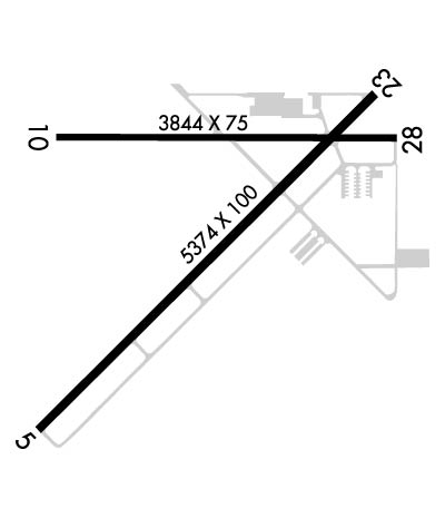 Airport Diagram might not be current. | |
| Facility Name: | AVON PARK EXEC |
| City Name: | AVON PARK |
| County: | HIGHLANDS |
| State abbrev: | FL |
| State Name: | FLORIDA |
| Ownership: | PUBLICLY OWNED |
| Use: | OPEN TO THE PUBLIC |
| Owner's Name: | CITY OF AVON PARK; GARRETT ANDERSON 863-452-4400 |
| Address: | 110 EAST MAIN STREET |
| AVON PARK, FL 33825 | |
| Owner's Phone: | 863-452-4400 |
| Manager's Name: | ANDREW LIVINGSTON; AIRPORT PHYSICAL ADDRESS: 1545 STATE RD 64 WEST, AVON PARK, FL 33825 FAX: 863-452-4413 |
| Address: | 1535 STATE ROAD 64 WEST |
| AVON PARK, FL 33825 | |
| Phone: | 863-446-3244 |
| FAA Region: | SOUTHERN |
| FAA Field Office: | ORL |
| Date | Sunrise | Sunset |
|---|---|---|
| 07/16/26 Thursday | 6:41 | 20:23 |
| 07/17/26 Friday | 6:41 | 20:23 |
| 07/18/26 Saturday | 6:42 | 20:23 |
| 07/19/26 Sunday | 6:42 | 20:22 |
| 07/20/26 Monday | 6:43 | 20:22 |
| 07/21/26 Tuesday | 6:43 | 20:21 |
| 07/22/26 Wednesday | 6:44 | 20:21 |
| 07/23/26 Thursday | 6:44 | 20:20 |
| 07/24/26 Friday | 6:45 | 20:20 |
| 07/25/26 Saturday | 6:45 | 20:19 |
| 07/26/26 Sunday | 6:46 | 20:19 |
| 07/27/26 Monday | 6:47 | 20:18 |
| 07/28/26 Tuesday | 6:47 | 20:18 |
| 07/29/26 Wednesday | 6:48 | 20:17 |
| Airport Attendance Schedule | MON-FRI 0800-1600; ON CALL SAT & SUN. CTC (863) 453-3565 FOR SVC AFTER HRS. CLSD HOLIDAYS. |
| Airport Status | OPERATIONAL (This Status can change at any time - please check NOTAMS) |
| Airport Lighting Schedule | MIRL RWY 05/23 & 10/28 PRESET LOW INTST DUSK-DAWN; TO INCR INTST AND ACTVT TWY LGTS, REIL RWY 05 & 23, AND PAPI RWY 05, 10, 23 & 28, - CTAF. |
| Airport Storage Available | Tie Downs |
| Extra Services Available | Crop Dusting, Flight Instruction |
| Wind Indicator | YES - (lighted) |
| Control Tower | NO |
| CTAF Frequency | 122.800 |
| Unicom Frequency | 122.800 |
| Rotating Beacon Color | WG; BEACON OTS INDEF |
| Segmented Circle | Y-L |
| Landing Fee | NO |
| Airport Inspected | STATE - performed by STATE AERONAUTICAL PERSONNEL |
| Inspection Date | 07/16/2025 |
| Type of Fuel Available | Grade 100LL, JET A (freeze point -40C) |
| Airframe Repair Service | MAJOR |
| Power Plant Repair Service | MAJOR |
| Latitude | N2735.5 |
| Longitude | W08131.7 (ESTIMATED) |
| Arpt Elevation | 160ft (SURVEYED) |
| Magnetic Variation | 05W |
| 2 miles W | of AVON PARK |
| Traffic Pattern Altitude | |
| Sectional Chart | MIAMI |
| Operations (Reported) | Yearly | Avg. Daily |
|---|---|---|
| General Aviation Transient | 0 | 0 |
| General Aviation Local | 0 | 0 |
| Air Taxi | 0 | 0 |
| Commerical | 0 | 0 |
| Commuter | 0 | 0 |
| Military | 0 | 0 |
| Aircraft based on Field | |
|---|---|
| General Aviation Singles | 0 |
| General Aviation Multi | 0 |
| Jet Aircraft | 0 |
| General Aviation Helicopters | 0 |
| Military Aircraft | 0 |
| Gliders | 0 |
| Ultralights | 0 |
| FSS on field | NO |
| FSS tie-in | SAINT PETERSBURG |
| FSS Phone | 1-800-WX-BRIEF |
| Who issues Notams | PIE |
| Notam D service at airport | YES |
| ARTCC Name | MIAMI |
| Airport Certification | |
| Aircraft Rescue & Firefighting Index | None |
| Airport of Entry | No |
| Custom Landing Rights | No |
| Joint Civil/Military | No |
| Military Landing rights | YES |
| NATIONAL PLAN OF INTEGRATED AIRPORT SYSTEMS (NPIAS) |
| GRANT AGREEMENTS UNDER FAAP/ADAP/AIP |
| SURPLUS PROPERTY AGREEMENT UNDER REGULATION 16-WAA |
| ASSURANCES PURSUANT TO TITLE VI, CIVIL RIGHTS ACT OF 1964 |
| FOR CD IF UNA TO CTC ON FSS FREQ, CTC MIAMI ARTCC AT 305-716-1731. |
| UNLGTD OBSTNS PRSNT IN THE APCH TO RY 23 DUE TO FENCE & ROAD 200 FT OF AER 23. |
Airport Communications & Frequencies:
| |||||||||
| Runway: 05 | Runway: 23 | ||
| Mag heading: | 50° | Mag heading: | 230° |
| Rwy Slope: | -.15% Down | Rwy Slope: | .15% Up |
| Approach: | Approach: | ||
| Pattern: | Left Traffic | Pattern: | Left Traffic |
| Markings: | NONPRECISION INSTRUMENT | Markings: | BASIC |
| Marking Condition: | FAIR | Marking Condition: | FAIR |
| Arresting Dev: | Arresting Dev: | ||
| Lat & Long: | N2735.1 W08132.1 | Lat. & Long.: | N2735.7 W08131.4 |
| Elev: | 160.3 ft. MSL | Elev: | 152.2 ft. MSL |
| TCH: | 39 ft. AGL | TCH: | 43 ft. AGL |
| Visual Glide Path: | 3.00 degrees | Visual Glide Path: | 3.00 degrees |
| Displaced Threshold: | No | Displaced Threshold: | 1044 feet |
| Touchdown Zone: | YES | Touchdown Zone: | YES |
| Touchdown Elev.: | 160.4 feet | Touchdown Elev.: | 155.0 feet |
| Visual Glide Slope: | 4-Light PAPI on LEFT side of Runway | Visual Glide Slope: | 4-Light PAPI on LEFT side of Runway |
| RVR Equipment: | RVR Equipment: | ||
| RVV Equipment: | NO | RVV Equipment: | NO |
| Approach Lights: | Approach Lights: | ||
| REIL: | YES | REIL: | YES |
| Centerline Lights: | NO | Centerline Lights: | NO |
| Touchdown lights: | NO | Touchdown lights: | NO |
| Runway Category: | Runway with a Non-precision Approach | Runway Category: | Runway with a Visual Approach |
| Declared Distances: | Declared Distances: | ||
| Obstructions: | BRUSH | Obstructions: | ROAD |
| Marked: | NOT Marked/Lighted | Marked: | NOT Marked/Lighted |
| Clearance slope: | 12:1 | Clearance slope: | RWY 23 APCH RATIO 28:1 TO DTHR. |
| Obstruction height: | 5 feet AGL | Obstruction height: | 15 feet AGL |
| Dist. from runway: | 265 feet | Dist. from runway: | 200 feet |
| Centerline offset: | 230 left of centerline | Centerline offset: | 250 feet right of centerline |
| Comments: | Comments: | RY 23, UNLGTD 15 FT ROAD; 90 FT FM END OF RWY, 250 FT RIGHT OF CNTRLN. |
| Runway: 10 | Runway: 28 | ||
| Mag heading: | 95° | Mag heading: | 275° |
| Rwy Slope: | -.03% Down | Rwy Slope: | .03% Up |
| Approach: | Approach: | ||
| Pattern: | Left Traffic | Pattern: | Left Traffic |
| Markings: | NONPRECISION INSTRUMENT | Markings: | BASIC |
| Marking Condition: | POOR; RWY 10/28 MARKINGS FADED. | Marking Condition: | POOR; RWY 10/28 MARKINGS FADED. |
| Arresting Dev: | Arresting Dev: | ||
| Lat & Long: | N2735.6 W08132.1 | Lat. & Long.: | N2735.6 W08131.4 |
| Elev: | 153.4 ft. MSL | Elev: | 152.2 ft. MSL |
| TCH: | 44 ft. AGL | TCH: | 58 ft. AGL |
| Visual Glide Path: | 3.00 degrees | Visual Glide Path: | 3.00 degrees |
| Displaced Threshold: | No | Displaced Threshold: | No |
| Touchdown Zone: | YES | Touchdown Zone: | YES |
| Touchdown Elev.: | 153.9 feet | Touchdown Elev.: | 153.9 feet |
| Visual Glide Slope: | 4-Light PAPI on LEFT side of Runway | Visual Glide Slope: | 4-Light PAPI on LEFT side of Runway |
| RVR Equipment: | RVR Equipment: | ||
| RVV Equipment: | NO | RVV Equipment: | NO |
| Approach Lights: | Approach Lights: | ||
| REIL: | NO | REIL: | NO |
| Centerline Lights: | NO | Centerline Lights: | NO |
| Touchdown lights: | NO | Touchdown lights: | NO |
| Runway Category: | Runway with a Non-precision Approach | Runway Category: | Runway with a Visual Approach |
| Declared Distances: | Declared Distances: | ||
| Obstructions: | TREES | Obstructions: | FENCE |
| Marked: | NOT Marked/Lighted | Marked: | NOT Marked/Lighted |
| Clearance slope: | 31:1 | Clearance slope: | 4:1 |
| Obstruction height: | 45 feet AGL | Obstruction height: | 5 feet AGL |
| Dist. from runway: | 1595 feet | Dist. from runway: | 221 feet |
| Centerline offset: | 60 right of centerline | Centerline offset: | 200 feet right of centerline |
| Comments: | Comments: |
Thanks for using FltPlan.com
all rights reserved © 1999-2026 by Flight Plan LLC
