| WAUSAU DOWNTOWN WAUSAU WI |
| |
| Lat: N 4455.6 Long: W 08937.6 Elev: 1201 Var: +03 Longest Runway: 8000 | ||
| AWOS: 125.92 CTAF: 122.7 | ||
| ||||||||||||||||||||||||||||||||||||||||||||||||||||||||||||||||||||
| ||||||||||||||||||||||||||||||||||||||||||||||||||||||||||||||||||||
| ||||||||||||||||||||||||||||||||||||||||||||||||||||||||||||||||||||
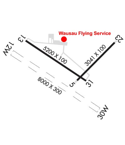
| Rwy | Rwy | |||||||
| 3041x100 | 3041' | 3041x100 | 3041' | |||||
| 8000x300 | 8000' | 8000x300 | 8000' | |||||
| 5200x100 | 5200' | 5200x100 | 5200' | |||||
| Runway ID | Single Wheel | Double Wheel | Double Tandem Wheel | Dual Double Wheel |
| 05/23 | 32,000 | 55,000 | 95,000 | N/A |
| 12W/30W | N/A | N/A | N/A | N/A |
| 13/31 | 45,000 | 80,000 | 140,000 | N/A |
| These numbers are Advisory and are not limits. The Airport Manager should have more accurate Weight Limits | ||||
 Airport Diagram might not be current. | |
| Facility Name: | WAUSAU DOWNTOWN |
| City Name: | WAUSAU |
| County: | MARATHON |
| State abbrev: | WI |
| State Name: | WISCONSIN |
| Ownership: | PUBLICLY OWNED |
| Use: | OPEN TO THE PUBLIC |
| Owner's Name: | CITY OF WAUSAU |
| Address: | 407 GRANT ST. |
| WAUSAU, WI 54403 | |
| Owner's Phone: | 715-261-6740 |
| Manager's Name: | JOHN P CHMIEL |
| Address: | 725 WOODS PLACE |
| WAUSAU, WI 54401 | |
| Phone: | 715-845-3400 |
| FAA Region: | GREAT LAKES |
| FAA Field Office: | CHI |
| Date | Sunrise | Sunset |
|---|---|---|
| 06/08/26 Monday | 5:12 | 20:43 |
| 06/09/26 Tuesday | 5:12 | 20:43 |
| 06/10/26 Wednesday | 5:12 | 20:44 |
| 06/11/26 Thursday | 5:12 | 20:45 |
| 06/12/26 Friday | 5:12 | 20:45 |
| 06/13/26 Saturday | 5:11 | 20:46 |
| 06/14/26 Sunday | 5:11 | 20:46 |
| 06/15/26 Monday | 5:11 | 20:47 |
| 06/16/26 Tuesday | 5:11 | 20:47 |
| 06/17/26 Wednesday | 5:11 | 20:47 |
| 06/18/26 Thursday | 5:11 | 20:48 |
| 06/19/26 Friday | 5:12 | 20:48 |
| 06/20/26 Saturday | 5:12 | 20:48 |
| 06/21/26 Sunday | 5:12 | 20:49 |
| Airport Attendance Schedule | 7 Days A Week 0800-1700 |
| Airport Status | OPERATIONAL (This Status can change at any time - please check NOTAMS) |
| Airport Lighting Schedule | MIRL RWY 13/31 PRESET TO LOW; TO INCR INTST AND ACTVT REILS RWY 13 & 31; PAPI RWY 13 & 31; MIRL RWY 5/23 - CTAF. |
| Airport Storage Available | Tie Downs, Hanger |
| Extra Services Available | Flight Instruction, Aircraft Rental |
| Wind Indicator | YES - (lighted) |
| Control Tower | NO |
| CTAF Frequency | 122.700 |
| Unicom Frequency | 122.700 |
| Rotating Beacon Color | WG |
| Segmented Circle | YES |
| Landing Fee | NO |
| Airport Inspected | STATE - performed by STATE AERONAUTICAL PERSONNEL |
| Inspection Date | 06/06/2024 |
| Type of Fuel Available | Grade 100LL, JET AMOGAS |
| Airframe Repair Service | MAJOR |
| Power Plant Repair Service | MAJOR |
| Latitude | N4455.6 |
| Longitude | W08937.6 (ESTIMATED) |
| Arpt Elevation | 1201ft (SURVEYED) |
| Magnetic Variation | 03W |
| 0 miles S | of WAUSAU |
| Traffic Pattern Altitude | |
| Sectional Chart | GREEN BAY |
| Operations (Reported) | Yearly | Avg. Daily |
|---|---|---|
| General Aviation Transient | 0 | 0 |
| General Aviation Local | 0 | 0 |
| Air Taxi | 0 | 0 |
| Commerical | 0 | 0 |
| Commuter | 0 | 0 |
| Military | 0 | 0 |
| Aircraft based on Field | |
|---|---|
| General Aviation Singles | 0 |
| General Aviation Multi | 0 |
| Jet Aircraft | 0 |
| General Aviation Helicopters | 0 |
| Military Aircraft | 0 |
| Gliders | 0 |
| Ultralights | 0 |
| FSS on field | NO |
| FSS tie-in | GREEN BAY |
| FSS Phone | 1-800-WX-BRIEF |
| Who issues Notams | AUW |
| Notam D service at airport | YES |
| ARTCC Name | MINNEAPOLIS |
| Airport Certification | |
| Aircraft Rescue & Firefighting Index | None |
| Airport of Entry | No |
| Custom Landing Rights | No |
| Joint Civil/Military | No |
| Military Landing rights | No |
| NATIONAL PLAN OF INTEGRATED AIRPORT SYSTEMS (NPIAS) |
| GRANT AGREEMENTS UNDER FAAP/ADAP/AIP |
| ASSURANCES PURSUANT TO TITLE VI, CIVIL RIGHTS ACT OF 1964 |
| FOR CD IF UNA TO CTC ON FSS FREQ, CTC MINNEAPOLIS ARTCC AT 651-463-5588. |
Airport Communications & Frequencies:
| |||||||||
| Runway: 05 | Runway: 23 | ||
| Mag heading: | 47° | Mag heading: | 227° |
| Rwy Slope: | .35% Up | Rwy Slope: | -.35% Down |
| Approach: | Approach: | ||
| Pattern: | Left Traffic | Pattern: | Left Traffic |
| Markings: | BASIC | Markings: | BASIC |
| Marking Condition: | FAIR | Marking Condition: | FAIR |
| Arresting Dev: | Arresting Dev: | ||
| Lat & Long: | N4455.4 W08937.5 | Lat. & Long.: | N4455.7 W08937.0 |
| Elev: | 1190.4 ft. MSL | Elev: | 1201.0 ft. MSL |
| TCH: | TCH: | ||
| Visual Glide Path: | Visual Glide Path: | ||
| Displaced Threshold: | No | Displaced Threshold: | No |
| Touchdown Zone: | YES | Touchdown Zone: | YES |
| Touchdown Elev.: | 1201.0 feet | Touchdown Elev.: | 1201.0 feet |
| Visual Glide Slope: | Visual Glide Slope: | ||
| RVR Equipment: | RVR Equipment: | ||
| RVV Equipment: | NO | RVV Equipment: | NO |
| Approach Lights: | Approach Lights: | ||
| REIL: | NO | REIL: | NO |
| Centerline Lights: | NO | Centerline Lights: | NO |
| Touchdown lights: | NO | Touchdown lights: | NO |
| Runway Category: | Runway with a Visual Approach | Runway Category: | Runway with a Visual Approach |
| Declared Distances: | Declared Distances: |
| Runway: 12W | Runway: 30W | ||
| Mag heading: | N/A | Mag heading: | N/A |
| Rwy Slope: | .00% | Rwy Slope: | .00% |
| Approach: | Approach: | ||
| Pattern: | Left Traffic | Pattern: | Left Traffic |
| Markings: | NONE | Markings: | NONE |
| Marking Condition: | GOOD | Marking Condition: | GOOD |
| Arresting Dev: | Arresting Dev: | ||
| Lat & Long: | N4455.8 W08938.7 | Lat. & Long.: | N4455.0 W08937.2 |
| Elev: | 1166.0 ft. MSL | Elev: | 1166.0 ft. MSL |
| TCH: | TCH: | ||
| Visual Glide Path: | Visual Glide Path: | ||
| Displaced Threshold: | No | Displaced Threshold: | No |
| Touchdown Zone: | YES | Touchdown Zone: | YES |
| Touchdown Elev.: | 1166.0 feet | Touchdown Elev.: | 1166.0 feet |
| Visual Glide Slope: | Visual Glide Slope: | ||
| RVR Equipment: | RVR Equipment: | ||
| RVV Equipment: | NO | RVV Equipment: | NO |
| Approach Lights: | Approach Lights: | ||
| REIL: | NO | REIL: | NO |
| Centerline Lights: | NO | Centerline Lights: | NO |
| Touchdown lights: | NO | Touchdown lights: | NO |
| Runway Category: | Runway Category: | ||
| Declared Distances: | Declared Distances: |
| Runway: 13 | Runway: 31 | ||
| Mag heading: | 127° | Mag heading: | 307° |
| Rwy Slope: | -.04% Down | Rwy Slope: | .04% Up |
| Approach: | Approach: | ||
| Pattern: | Left Traffic | Pattern: | Left Traffic |
| Markings: | NONPRECISION INSTRUMENT | Markings: | NONPRECISION INSTRUMENT |
| Marking Condition: | FAIR | Marking Condition: | FAIR |
| Arresting Dev: | Arresting Dev: | ||
| Lat & Long: | N4455.8 W08938.4 | Lat. & Long.: | N4455.4 W08937.4 |
| Elev: | 1192.1 ft. MSL | Elev: | 1190.1 ft. MSL |
| TCH: | 43 ft. AGL | TCH: | 44 ft. AGL |
| Visual Glide Path: | 3.00 degrees | Visual Glide Path: | 3.00 degrees |
| Displaced Threshold: | No | Displaced Threshold: | No |
| Touchdown Zone: | YES | Touchdown Zone: | YES |
| Touchdown Elev.: | 1195.7 feet | Touchdown Elev.: | 1195.3 feet |
| Visual Glide Slope: | 4-Light PAPI on LEFT side of Runway | Visual Glide Slope: | 4-Light PAPI on LEFT side of Runway |
| RVR Equipment: | RVR Equipment: | ||
| RVV Equipment: | NO | RVV Equipment: | NO |
| Approach Lights: | Approach Lights: | ||
| REIL: | YES | REIL: | YES |
| Centerline Lights: | NO | Centerline Lights: | NO |
| Touchdown lights: | NO | Touchdown lights: | NO |
| Runway Category: | D | Runway Category: | Runway with a Non-precision Approach having visibility minimums greater than 3/4 mile |
| Declared Distances: | Declared Distances: | ||
| Obstructions: | TREES | Obstructions: | TREES |
| Marked: | NOT Marked/Lighted | Marked: | NOT Marked/Lighted |
| Clearance slope: | 1:1 | Clearance slope: | |
| Obstruction height: | 34 feet AGL | Obstruction height: | 38 feet AGL |
| Dist. from runway: | 250 feet | Dist. from runway: | 225 feet |
| Centerline offset: | 410 left of centerline | Centerline offset: | 375 feet left of centerline |
| Comments: | 40 FT TREES 0-200 FT FM THR 300 FT R & 450 FT L. | Comments: | 30 FT TREES 150 FT FM THR 425 FT L. |
Thanks for using FltPlan.com
all rights reserved © 1999-2026 by Flight Plan LLC