
| AUBURN-OPELIKA ROBERT G. PITTS AUBURN AL |
| |
| Lat: N 3236.9 Long: W 08526.0 Elev: 777 Var: +04 Longest Runway: 5264 | ||
| Clr Del: 118.7 AWOS: 132.57 Ground: 121.62 Tower: 123.87 | ||
| |||||||||||||||||||||||||||||||||||||||||||||||||||||||||||||
| |||||||||||||||||||||||||||||||||||||||||||||||||||||||||||||
| |||||||||||||||||||||||||||||||||||||||||||||||||||||||||||||
| Rwy | Rwy | |||||||
| 4000x75 | 4000' | 4000x75 | 3703' | |||||
| 5264x100 | 5264' | 5264x100 | 5264' | 110.10 - 005° | ||||
| Runway ID | Single Wheel | Double Wheel | Double Tandem Wheel | Dual Double Wheel |
| 11/29 | 25,000 | 42,000 | N/A | N/A |
| 18/36 | 45,000 | 75,000 | N/A | N/A |
| These numbers are Advisory and are not limits. The Airport Manager should have more accurate Weight Limits | ||||
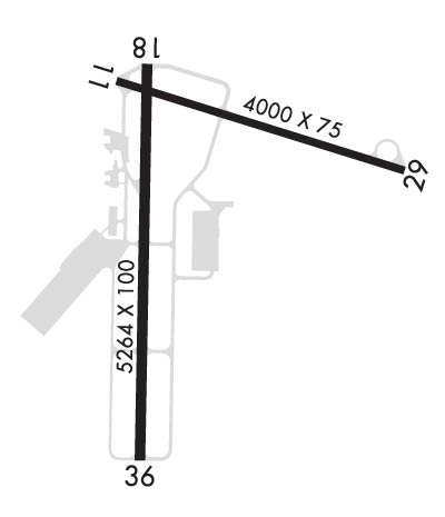 Airport Diagram might not be current. | |
| Facility Name: | AUBURN UNIVERSITY RGNL |
| City Name: | AUBURN |
| County: | LEE |
| State abbrev: | AL |
| State Name: | ALABAMA |
| Ownership: | PUBLICLY OWNED |
| Use: | OPEN TO THE PUBLIC |
| Owner's Name: | AUBURN UNIVERSITY |
| Address: | 2150 BENT CREEK RD. |
| AUBURN, AL 36830 | |
| Owner's Phone: | 334-844-4597 |
| Manager's Name: | WILLIAM T. HUTTO |
| Address: | 2150 BENT CREEK RD. |
| AUBURN, AL 36830 | |
| Phone: | 334-844-4606 |
| FAA Region: | SOUTHERN |
| FAA Field Office: | JAN |

| Date | Sunrise | Sunset |
|---|---|---|
| 06/07/26 Sunday | 5:34 | 19:47 |
| 06/08/26 Monday | 5:34 | 19:48 |
| 06/09/26 Tuesday | 5:34 | 19:48 |
| 06/10/26 Wednesday | 5:34 | 19:49 |
| 06/11/26 Thursday | 5:33 | 19:49 |
| 06/12/26 Friday | 5:33 | 19:50 |
| 06/13/26 Saturday | 5:34 | 19:50 |
| 06/14/26 Sunday | 5:34 | 19:50 |
| 06/15/26 Monday | 5:34 | 19:51 |
| 06/16/26 Tuesday | 5:34 | 19:51 |
| 06/17/26 Wednesday | 5:34 | 19:51 |
| 06/18/26 Thursday | 5:34 | 19:52 |
| 06/19/26 Friday | 5:34 | 19:52 |
| 06/20/26 Saturday | 5:34 | 19:52 |
| Airport Attendance Schedule | MON-FRI 0700-2100, SAT-SUN 0800-1700 |
| Airport Status | OPERATIONAL (This Status can change at any time - please check NOTAMS) |
| Airport Lighting Schedule | WHEN ATCT CLSD, ACTVT MALSF RWY 36; PAPI RWY 29 & 36; MIRL RWY 11/29; HIRL RWY 18/36 - CTAF. |
| Airport Storage Available | Tie Downs |
| Extra Services Available | Charter, Flight Instruction, Aircraft Rental, Aircraft Sales |
| Wind Indicator | YES - (lighted) |
| Control Tower | YES |
| CTAF Frequency | 123.875 |
| Unicom Frequency | 123.000 |
| Rotating Beacon Color | WG |
| Segmented Circle | YES |
| Landing Fee | NO |
| Airport Inspected | STATE - performed by STATE AERONAUTICAL PERSONNEL |
| Inspection Date | 03/09/2026 |
| Type of Fuel Available | Grade 100LL, JET A (freeze point -40C), JET A; -10SVC AFT HRS & HOL 334-501-3100. |
| Airframe Repair Service | NONE |
| Power Plant Repair Service | NONE |
| Latitude | N3236.9 |
| Longitude | W08526.0 (ESTIMATED) |
| Arpt Elevation | 776ft (SURVEYED) |
| Magnetic Variation | 04W |
| 2 miles E | of AUBURN |
| Traffic Pattern Altitude | |
| Sectional Chart | ATLANTA |
| Operations (Reported) | Yearly | Avg. Daily |
|---|---|---|
| General Aviation Transient | 0 | 0 |
| General Aviation Local | 0 | 0 |
| Air Taxi | 0 | 0 |
| Commerical | 0 | 0 |
| Commuter | 0 | 0 |
| Military | 0 | 0 |
| Aircraft based on Field | |
|---|---|
| General Aviation Singles | 0 |
| General Aviation Multi | 0 |
| Jet Aircraft | 0 |
| General Aviation Helicopters | 0 |
| Military Aircraft | 0 |
| Gliders | 0 |
| Ultralights | 0 |
| FSS on field | NO |
| FSS tie-in | ANNISTON |
| FSS Phone | 1-800-WX-BRIEF |
| Who issues Notams | AUO |
| Notam D service at airport | YES |
| ARTCC Name | ATLANTA |
| Airport Certification | |
| Aircraft Rescue & Firefighting Index | None |
| Airport of Entry | No |
| Custom Landing Rights | No |
| Joint Civil/Military | No |
| Military Landing rights | YES |
| NATIONAL PLAN OF INTEGRATED AIRPORT SYSTEMS (NPIAS) |
| GRANT AGREEMENTS UNDER FAAP/ADAP/AIP |
| ASSURANCES PURSUANT TO TITLE VI, CIVIL RIGHTS ACT OF 1964 |
| AGREEMENT UNDER DLAND OR DCLA HAS EXPIRED. |
| JET START CPBLTY AVBL. |
| HVY FLT STUDENT ACTVTY WI 35NM OF ARPT. |
Airport Communications & Frequencies:
| |||||||||||||||||||||||||||||||||
| Runway: 11 | Runway: 29 | ||
| Mag heading: | 111° | Mag heading: | 291° |
| Rwy Slope: | -.22% Down | Rwy Slope: | .22% Up |
| Approach: | Approach: | ||
| Pattern: | Left Traffic | Pattern: | Left Traffic |
| Markings: | NONPRECISION INSTRUMENT | Markings: | NONPRECISION INSTRUMENT |
| Marking Condition: | GOOD | Marking Condition: | GOOD |
| Arresting Dev: | Arresting Dev: | ||
| Lat & Long: | N3237.2 W08526.2 | Lat. & Long.: | N3237.0 W08525.5 |
| Elev: | 774.9 ft. MSL | Elev: | 766.3 ft. MSL |
| TCH: | TCH: | 22 ft. AGL | |
| Visual Glide Path: | Visual Glide Path: | 3.00 degrees | |
| Displaced Threshold: | No | Displaced Threshold: | 297 feet |
| Touchdown Zone: | YES | Touchdown Zone: | YES |
| Touchdown Elev.: | 774.9 feet | Touchdown Elev.: | 770.4 feet |
| Visual Glide Slope: | Visual Glide Slope: | 4-Light PAPI on LEFT side of Runway | |
| RVR Equipment: | RVR Equipment: | ||
| RVV Equipment: | NO | RVV Equipment: | NO |
| Approach Lights: | Approach Lights: | ||
| REIL: | NO | REIL: | NO |
| Centerline Lights: | NO | Centerline Lights: | NO |
| Touchdown lights: | NO | Touchdown lights: | NO |
| Runway Category: | Runway with a Non-precision Approach having visibility minimums greater than 3/4 mile | Runway Category: | Runway with a Non-precision Approach having visibility minimums greater than 3/4 mile |
| Declared Distances: | Declared Distances: | ||
| Obstructions: | TREES | Obstructions: | TREE |
| Marked: | NOT Marked/Lighted | Marked: | NOT Marked/Lighted |
| Clearance slope: | 7:1 | Clearance slope: | 11:1; APCH RATIO 26:1 FROM DSPLCD THLD. |
| Obstruction height: | 22 feet AGL | Obstruction height: | 63 feet AGL |
| Dist. from runway: | 372 feet | Dist. from runway: | 954 feet |
| Centerline offset: | 192 left of centerline | Centerline offset: | 379 feet right of centerline |
| Comments: | Comments: |
| Runway: 18 | Runway: 36 | ||
| Mag heading: | 185° | Mag heading: | 5° |
| Rwy Slope: | -.87% Down | Rwy Slope: | .87% Up |
| Approach: | Approach: | ILS/DME | |
| Pattern: | Left Traffic | Pattern: | Left Traffic |
| Markings: | PRECISION INSTRUMENT | Markings: | PRECISION INSTRUMENT |
| Marking Condition: | GOOD | Marking Condition: | GOOD |
| Arresting Dev: | Arresting Dev: | ||
| Lat & Long: | N3237.2 W08526.2 | Lat. & Long.: | N3236.3 W08526.2 |
| Elev: | 776.8 ft. MSL | Elev: | 731.1 ft. MSL |
| TCH: | TCH: | 44 ft. AGL | |
| Visual Glide Path: | Visual Glide Path: | 3.00 degrees | |
| Displaced Threshold: | No | Displaced Threshold: | No |
| Touchdown Zone: | YES | Touchdown Zone: | YES |
| Touchdown Elev.: | 776.8 feet | Touchdown Elev.: | 759.1 feet |
| Visual Glide Slope: | Visual Glide Slope: | 4-Light PAPI on LEFT side of Runway | |
| RVR Equipment: | RVR Equipment: | ||
| RVV Equipment: | NO | RVV Equipment: | NO |
| Approach Lights: | Approach Lights: | MALSF - 1,400 foot medium intensity approach lighting system with sequenced flashers | |
| REIL: | NO | REIL: | NO |
| Centerline Lights: | NO | Centerline Lights: | NO |
| Touchdown lights: | NO | Touchdown lights: | NO |
| Runway Category: | Runway with a Non-precision Approach having visibility minimums greater than 3/4 mile | Runway Category: | Precision Instrument Runway |
| Declared Distances: | Declared Distances: | ||
| Obstructions: | TREE | Obstructions: | TREE |
| Marked: | NOT Marked/Lighted | Marked: | NOT Marked/Lighted |
| Clearance slope: | 23:1 | Clearance slope: | 1:1 |
| Obstruction height: | 43 feet AGL | Obstruction height: | 8 feet AGL |
| Dist. from runway: | 1204 feet | Dist. from runway: | 212 feet |
| Centerline offset: | 367 right of centerline | Centerline offset: | 300 feet right of centerline |
| Comments: | Comments: |
Thanks for using FltPlan.com
all rights reserved © 1999-2026 by Flight Plan LLC
