| AUGUSTA STATE AUGUSTA ME |
| |
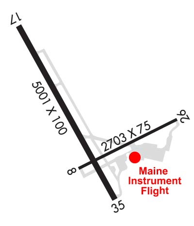
| Lat: N 4419.2 Long: W 06947.8 Elev: 352 Var: +18 Longest Runway: 5001 | ||
| Clr Del: 119.95 AWOS: 118.32 CTAF: 123.0 | ||
| |||||||||||||||||||||||||||||||||||||||||||||||||||||||||||||||||||||
| |||||||||||||||||||||||||||||||||||||||||||||||||||||||||||||||||||||
| |||||||||||||||||||||||||||||||||||||||||||||||||||||||||||||||||||||
| Rwy | Rwy | |||||||
| 2703x75 | 2703' | 2703x75 | 2703' | |||||
| 5001x100 | 5001' | 108.70 - 171° | 5001x100 | 5001' | ||||
| Runway ID | Single Wheel | Double Wheel | Double Tandem Wheel | Dual Double Wheel |
| 08/26 | 30,000 | N/A | N/A | N/A |
| 17/35 | 50,000 | 60,000 | N/A | N/A |
| These numbers are Advisory and are not limits. The Airport Manager should have more accurate Weight Limits | ||||
 Airport Diagram might not be current. | |
| Facility Name: | AUGUSTA STATE |
| City Name: | AUGUSTA |
| County: | KENNEBEC |
| State abbrev: | ME |
| State Name: | MAINE |
| Ownership: | PUBLICLY OWNED |
| Use: | OPEN TO THE PUBLIC |
| Owner's Name: | STATE OF MAINE |
| Address: | 16 STATE HOUSE STATION |
| AUGUSTA, ME 04333 | |
| Owner's Phone: | 207-624-3250 |
| Manager's Name: | JOHN GUIMOND |
| Address: | 75 AIRPORT RD |
| AUGUSTA, ME 04330 | |
| Phone: | 207-626-2306 |
| FAA Region: | NEW ENGLAND |
| FAA Field Office: | NONE |
| Date | Sunrise | Sunset |
|---|---|---|
| 09/24/21 Friday | 6:28 | 18:33 |
| 09/25/21 Saturday | 6:29 | 18:32 |
| 09/26/21 Sunday | 6:31 | 18:30 |
| 09/27/21 Monday | 6:32 | 18:28 |
| 09/28/21 Tuesday | 6:33 | 18:26 |
| 09/29/21 Wednesday | 6:34 | 18:24 |
| 09/30/21 Thursday | 6:35 | 18:22 |
| 10/01/21 Friday | 6:37 | 18:20 |
| 10/02/21 Saturday | 6:38 | 18:19 |
| 10/03/21 Sunday | 6:39 | 18:17 |
| 10/04/21 Monday | 6:40 | 18:15 |
| 10/05/21 Tuesday | 6:41 | 18:13 |
| 10/06/21 Wednesday | 6:43 | 18:11 |
| 10/07/21 Thursday | 6:44 | 18:10 |
| Airport Attendance Schedule | 7 Days A Week 0700-2000; ARPT UNATNDD AFDK DURG SN AND ICE SEASON. FLD COND RPRTS, SN DEPTHS & BA MAY NOT BE AVBL FOR RWYS FM 1800 TO 0600. |
| Airport Status | OPERATIONAL (This Status can change at any time - please check NOTAMS) |
| Airport Lighting Schedule | ACTVT MALSR RWY 17; REIL RWY 35; PAPI RWY 17 & 35; HIRL RWY 17/35; MIRL RWY 08/26 - CTAF. |
| Airport Storage Available | Tie Downs, Hanger |
| Extra Services Available | Air Freight, Air Ambulance, Charter, Flight Instruction, Aircraft Rental, Aircraft Sales |
| Wind Indicator | YES - (lighted) |
| Control Tower | NO |
| CTAF Frequency | 123.000 |
| Unicom Frequency | 123.000 |
| Rotating Beacon Color | CLEAR-GREEN (Light Land Airport) |
| Segmented Circle | YES |
| Landing Fee | YES |
| Airport Inspected | STATE - performed by PRIVATE CONTRACT PERSONNEL |
| Inspection Date | 08/12/2019 |
| Type of Fuel Available | Grade 100LL, JET A (freeze point -40C); -10FOR FUEL AFTER NORMAL BUS HRS CALL 207-622-2507. |
| Airframe Repair Service | MAJOR |
| Power Plant Repair Service | MAJOR |
| Latitude | N4419.2 |
| Longitude | W06947.8 (ESTIMATED) |
| Arpt Elevation | 351ft (SURVEYED) |
| Magnetic Variation | 18W |
| 1 miles NW | of AUGUSTA |
| Traffic Pattern Altitude | 1048 |
| Sectional Chart | MONTREAL |
| Operations (Reported) | Yearly | Avg. Daily |
|---|---|---|
| General Aviation Transient | 3225 | 9 |
| General Aviation Local | 12203 | 33 |
| Air Taxi | 4620 | 13 |
| Commerical | 0 | 0 |
| Commuter | 0 | 0 |
| Military | 1307 | 4 |
| Aircraft based on Field | |
|---|---|
| General Aviation Singles | 39 |
| General Aviation Multi | 8 |
| Jet Aircraft | 0 |
| General Aviation Helicopters | 0 |
| Military Aircraft | 0 |
| Gliders | 0 |
| Ultralights | 0 |
| FSS on field | NO |
| FSS tie-in | BANGOR |
| FSS Phone | 1-800-WX-BRIEF |
| Who issues Notams | AUG |
| Notam D service at airport | YES |
| ARTCC Name | BOSTON |
| Airport Certification | |
| Aircraft Rescue & Firefighting Index | None |
| Airport of Entry | No |
| Custom Landing Rights | No |
| Joint Civil/Military | No |
| Military Landing rights | YES |
| NATIONAL PLAN OF INTEGRATED AIRPORT SYSTEMS (NPIAS) |
| GRANT AGREEMENTS UNDER FAAP/ADAP/AIP |
| SURPLUS PROPERTY AGREEMENT UNDER PUBLIC LAW 289 |
| ASSURANCES PURSUANT TO TITLE VI, CIVIL RIGHTS ACT OF 1964 |
| AGREEMENT UNDER DLAND OR DCLA HAS EXPIRED. |
| THIS AIRPORT HAS BEEN SURVEYED BY THE NATIONAL GEODETIC SURVEY. |
| RWY 35 DESIGNATED CALM WIND RWY. |
| ACR RAMP CLSD TO GA TFC. |
| RWY 17/35 HAVE EMAS CATEGORY B2 |
| FOR CD WHEN PORTLAND APCH CLSD, CTC BOSTON ARTCC AT 603-879-6859. |
| TWY F EAST CLSD TO ALL ACFT WITH WING SPAN GTR THAN 45 FT. |
| LDG FEE FOR MULTI-ENG ACFT; FEE WAIVED WITH FUEL PURCHASE. |
| BIRDS & DEER ON & INVOF ARPT. |
Airport Communications & Frequencies:
| |||||||||||||||||||||
| Runway: 08 | Runway: 26 | ||
| Mag heading: | 80° | Mag heading: | 260° |
| Rwy Slope: | .09% Up | Rwy Slope: | -.09% Down |
| Approach: | Approach: | ||
| Pattern: | Left Traffic | Pattern: | Left Traffic |
| Markings: | NONPRECISION INSTRUMENT | Markings: | NONPRECISION INSTRUMENT |
| Marking Condition: | GOOD | Marking Condition: | GOOD |
| Arresting Dev: | Arresting Dev: | ||
| Lat & Long: | N4419.0 W06947.9 | Lat. & Long.: | N4419.2 W06947.3 |
| Elev: | 349.3 ft. MSL | Elev: | 351.7 ft. MSL |
| TCH: | TCH: | ||
| Visual Glide Path: | Visual Glide Path: | ||
| Displaced Threshold: | No | Displaced Threshold: | No |
| Touchdown Zone: | YES | Touchdown Zone: | YES |
| Touchdown Elev.: | 351.5 feet | Touchdown Elev.: | 351.7 feet |
| Visual Glide Slope: | Visual Glide Slope: | ||
| RVR Equipment: | RVR Equipment: | ||
| RVV Equipment: | NO | RVV Equipment: | NO |
| Approach Lights: | Approach Lights: | ||
| REIL: | NO | REIL: | NO |
| Centerline Lights: | NO | Centerline Lights: | NO |
| Touchdown lights: | NO | Touchdown lights: | NO |
| Runway Category: | Runway with a Non-precision Approach | Runway Category: | Runway with a Visual Approach |
| Declared Distances: | TORA:2703' TODA:2703' ASDA:2703' LDA:2703' | Declared Distances: | TORA:2703' TODA:2703' ASDA:2703' LDA:2703' |
| Obstructions: | TREES | Obstructions: | FENCE |
| Marked: | NOT Marked/Lighted | Marked: | LIGHTED |
| Clearance slope: | 16:1 | Clearance slope: | |
| Obstruction height: | 12 feet AGL | Obstruction height: | 6 feet AGL |
| Dist. from runway: | 398 feet | Dist. from runway: | 201 feet |
| Centerline offset: | 115 left of centerline | Centerline offset: | 131 feet left of centerline |
| Comments: | Comments: | ROAD & FENCE LEFT OF APCH, 0-200 FT FM RWY END, LGTD. |
| Runway: 17 | Runway: 35 | ||
| Mag heading: | 171° | Mag heading: | 351° |
| Rwy Slope: | .73% Up | Rwy Slope: | -.73% Down |
| Approach: | ILS | Approach: | |
| Pattern: | Left Traffic | Pattern: | Left Traffic |
| Markings: | PRECISION INSTRUMENT | Markings: | PRECISION INSTRUMENT |
| Marking Condition: | GOOD | Marking Condition: | GOOD |
| Arresting Dev: | EMAS; ENGINEERED MATERIALS ARRESTING SYSTEM (EMAS) 130 FT IN LENGTH BY 122 FT IN WIDTH LCTD AT DER 17. | Arresting Dev: | EMAS; ENGINEERED MATERIALS ARRESTING SYSTEM (EMAS) 150 FT IN LENGTH BY 122 FT IN WIDTH LCTD AT DER 35. |
| Lat & Long: | N4419.7 W06948.2 | Lat. & Long.: | N4418.9 W06947.7 |
| Elev: | 310.5 ft. MSL | Elev: | 346.8 ft. MSL |
| TCH: | 53 ft. AGL | TCH: | 40 ft. AGL |
| Visual Glide Path: | 3.00 degrees | Visual Glide Path: | 3.00 degrees |
| Displaced Threshold: | No | Displaced Threshold: | No |
| Touchdown Zone: | YES | Touchdown Zone: | YES |
| Touchdown Elev.: | 347.9 feet | Touchdown Elev.: | 350.0 feet |
| Visual Glide Slope: | 4-Light PAPI on LEFT side of Runway | Visual Glide Slope: | 4-Light PAPI on LEFT side of Runway |
| RVR Equipment: | RVR Equipment: | ||
| RVV Equipment: | NO | RVV Equipment: | NO |
| Approach Lights: | MALSR - 1,400 foot medium intensity approach lighting system with runway alignment indicator lights | Approach Lights: | |
| REIL: | NO | REIL: | YES |
| Centerline Lights: | NO | Centerline Lights: | NO |
| Touchdown lights: | NO | Touchdown lights: | NO |
| Runway Category: | Precision Instrument Runway | Runway Category: | Runway with a Non-precision Approach having visibility minimums greater than 3/4 mile |
| Declared Distances: | TORA:5001' TODA:5001' ASDA:5001' LDA:5001' | Declared Distances: | TORA:5001' TODA:5001' ASDA:5001' LDA:5001' |
| Obstructions: | Obstructions: | ROAD | |
| Marked: | Marked: | LIGHTED | |
| Clearance slope: | 50:1 | Clearance slope: | |
| Obstruction height: | Obstruction height: | 15 feet AGL | |
| Dist. from runway: | Dist. from runway: | 201 feet | |
| Centerline offset: | Centerline offset: | 255 feet right of centerline | |
| Comments: | Comments: | ROAD 240 FT RIGHT, 0-200 FT FROM RWY END. |
Thanks for using FltPlan.com
all rights reserved © 1999-2021 by Flight Plan LLC