
| APPLETON INT'L. AIRPORT APPLETON WI |
| |
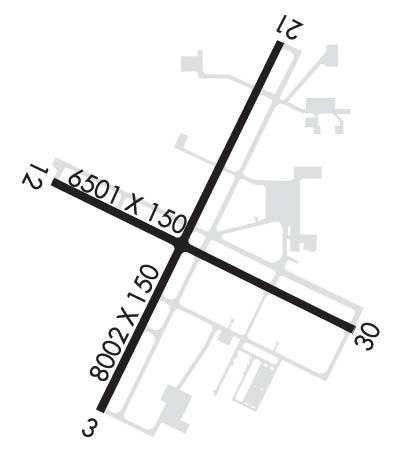
| Lat: N 4415.5 Long: W 08831.1 Elev: 918 Var: +02 Longest Runway: 8003 | ||
| Dept. ATIS: 127.15 Arr. ATIS: 127.15 Ground: 121.7 Tower: 119.6 | ||
| ||||||||||||||||||||||||||||||||||||||||||||
| ||||||||||||||||||||||||||||||||||||||||||||
| ||||||||||||||||||||||||||||||||||||||||||||
| ||||||||||||||||||||||||||||||||||||||||||||
| Rwy | Rwy | |||||||
| 8003x150 | 8003' | 109.10 - 028° | 8003x150 | 8003' | ||||
| 6502x150 | 6502' | 6502x150 | 6502' | 109.70 - 298° | ||||
| Runway ID | Single Wheel | Double Wheel | Double Tandem Wheel | Dual Double Wheel |
| 03/21 | 120,000 | 250,000 | 524,000 | 1,043,000 |
| 12/30 | 120,000 | 224,000 | 360,000 | 835,000 |
| These numbers are Advisory and are not limits. The Airport Manager should have more accurate Weight Limits | ||||
 Airport Diagram might not be current. | |
| Facility Name: | APPLETON INTL |
| City Name: | APPLETON |
| County: | OUTAGAMIE |
| State abbrev: | WI |
| State Name: | WISCONSIN |
| Ownership: | PUBLICLY OWNED |
| Use: | OPEN TO THE PUBLIC |
| Owner's Name: | OUTAGAMIE COUNTY |
| Address: | W6390 CHALLENGER DR-SUITE 201 |
| APPLETON, WI 54915 | |
| Owner's Phone: | 920-832-5267 |
| Manager's Name: | ABE WEBER, AIRPORT DIRECTOR |
| Address: | W6390 CHALLENGER DR-SUITE 201 |
| APPLETON, WI 54914-9119 | |
| Phone: | 920-832-5267 |
| FAA Region: | GREAT LAKES |
| FAA Field Office: | CHI |
| Date | Sunrise | Sunset |
|---|---|---|
| 07/24/25 Thursday | 5:33 | 20:28 |
| 07/25/25 Friday | 5:34 | 20:27 |
| 07/26/25 Saturday | 5:35 | 20:26 |
| 07/27/25 Sunday | 5:36 | 20:25 |
| 07/28/25 Monday | 5:37 | 20:24 |
| 07/29/25 Tuesday | 5:38 | 20:22 |
| 07/30/25 Wednesday | 5:39 | 20:21 |
| 07/31/25 Thursday | 5:40 | 20:20 |
| 08/01/25 Friday | 5:41 | 20:19 |
| 08/02/25 Saturday | 5:42 | 20:18 |
| 08/03/25 Sunday | 5:43 | 20:16 |
| 08/04/25 Monday | 5:45 | 20:15 |
| 08/05/25 Tuesday | 5:46 | 20:14 |
| 08/06/25 Wednesday | 5:47 | 20:12 |
| Airport Attendance Schedule | CONTINUOUS |
| Airport Status | OPERATIONAL (This Status can change at any time - please check NOTAMS) |
| Airport Lighting Schedule | WHEN ATCT CLSD HIRL RWY 03/21 PRESET ON LOW INTST; TO INCR INTST & ACTVT MALSR RWY 03, 30; REIL RWY 12, 21; PAPI RWY 12; HIRL RWY 03/21, 12/30 - CTAF. |
| Airport Storage Available | Tie Downs, Hanger |
| Extra Services Available | Air Freight, Avionics, Charter, Flight Instruction, Aircraft Rental, Aircraft Sales |
| Wind Indicator | YES - (lighted) |
| Control Tower | YES |
| CTAF Frequency | 119.600 |
| Unicom Frequency | 122.950 |
| Rotating Beacon Color | WG |
| Segmented Circle | NO |
| Landing Fee | NO |
| Airport Inspected | FEDERAL - performed by FAA AIRPORTS FIELD PERSONNEL |
| Inspection Date | 04/01/2025 |
| Type of Fuel Available | Grade 100LL, JET A (freeze point -40C) |
| Airframe Repair Service | MAJOR |
| Power Plant Repair Service | MAJOR |
| Latitude | N4415.5 |
| Longitude | W08831.1 (ESTIMATED) |
| Arpt Elevation | 918ft (SURVEYED) |
| Magnetic Variation | 02W |
| 3 miles W | of APPLETON |
| Traffic Pattern Altitude | |
| Sectional Chart | GREEN BAY |
| Operations (Reported) | Yearly | Avg. Daily |
|---|---|---|
| General Aviation Transient | 0 | 0 |
| General Aviation Local | 0 | 0 |
| Air Taxi | 0 | 0 |
| Commerical | 0 | 0 |
| Commuter | 0 | 0 |
| Military | 0 | 0 |
| Aircraft based on Field | |
|---|---|
| General Aviation Singles | 0 |
| General Aviation Multi | 0 |
| Jet Aircraft | 0 |
| General Aviation Helicopters | 0 |
| Military Aircraft | 0 |
| Gliders | 0 |
| Ultralights | 0 |
| FSS on field | NO |
| FSS tie-in | GREEN BAY |
| FSS Phone | 1-800-WX-BRIEF |
| Who issues Notams | ATW |
| Notam D service at airport | YES |
| ARTCC Name | CHICAGO |
| Airport Certification | AIRPORT RECEIVING SCHEDULED AIR CARRIER SERVICE FROM CARRIERS CERTIFICATED BY THE CIVIL AERONAUTICS BOARD |
| Aircraft Rescue & Firefighting Index | AIRPORT HAS A CERTIFICATE UNDER CFR PART 139 |
| Airport of Entry | No |
| Custom Landing Rights | No; US CUSTOMS USER FEE ARPT. |
| Joint Civil/Military | No |
| Military Landing rights | YES |
| NATIONAL PLAN OF INTEGRATED AIRPORT SYSTEMS (NPIAS) |
| GRANT AGREEMENTS UNDER FAAP/ADAP/AIP |
| ASSURANCES PURSUANT TO TITLE VI, CIVIL RIGHTS ACT OF 1964 |
| BIRDS & MIGRATORY WATERFOWL ON & INVOF ARPT. |
| SNOW REMOVAL OPNS IN PROGRESS WINTER MONTHS. VEHICLE OPERATORS WILL BE MONITORING CTAF; ACFT LNDG/DEP APPLETON SHOULD USE CTAF WHEN ATCT CLSD. |
| US CSTMS AND BORDER PROTECTION. PPR US CSTMS SVC MON-FRI 1300-2100Z (0800-1600 LOCAL) CALL 920-968-2348. |
| WHEN ATCT CLSD, FOR CD CTC GREEN BAY APCH ON FREQ, IF UNA CTC MINNEAPOLIS ARTCC AT 651-463-5588. |
| PERIODIC LIVE FIRE TRNG SOUTH SIDE OF ARPT. |
| COML RAMP DEICING PADS ARE AVBL FOR LIVE ENG RUN OPN DRG DEICING. |
| RWY 03/2 1 PCR VALUE: 1000/R/C/W/T |
| RWY 12/3 0 PCR VALUE: 730/R/C/W/T |
Airport Communications & Frequencies:
| |||||||||||||||||||||||
| Runway: 03 | Runway: 21 | ||
| Mag heading: | 28° | Mag heading: | 208° |
| Rwy Slope: | -.12% Down | Rwy Slope: | .12% Up |
| Approach: | ILS/DME | Approach: | |
| Pattern: | Left Traffic | Pattern: | Left Traffic |
| Markings: | PRECISION INSTRUMENT | Markings: | PRECISION INSTRUMENT |
| Marking Condition: | GOOD | Marking Condition: | GOOD |
| Arresting Dev: | Arresting Dev: | ||
| Lat & Long: | N4414.9 W08831.6 | Lat. & Long.: | N4416.1 W08830.8 |
| Elev: | 887.5 ft. MSL | Elev: | 877.9 ft. MSL |
| TCH: | 47 ft. AGL | TCH: | 47 ft. AGL |
| Visual Glide Path: | 3.00 degrees | Visual Glide Path: | 3.00 degrees |
| Displaced Threshold: | No | Displaced Threshold: | No |
| Touchdown Zone: | YES | Touchdown Zone: | YES |
| Touchdown Elev.: | 887.5 feet | Touchdown Elev.: | 879.3 feet |
| Visual Glide Slope: | 4-Light PAPI on LEFT side of Runway; OPERATES CONTINUOUSLY. | Visual Glide Slope: | 4-Light PAPI on LEFT side of Runway; OPERATES CONTINUOUSLY. PAPI RESTRICTED BYD 8.5 DEG RGT OF COURSE. |
| RVR Equipment: | TOUCHDOWN | RVR Equipment: | ROLLOUT |
| RVV Equipment: | NO | RVV Equipment: | NO |
| Approach Lights: | MALSR - 1,400 foot medium intensity approach lighting system with runway alignment indicator lights | Approach Lights: | |
| REIL: | NO | REIL: | YES |
| Centerline Lights: | NO | Centerline Lights: | NO |
| Touchdown lights: | NO | Touchdown lights: | NO |
| Runway Category: | Precision Instrument Runway | Runway Category: | Runway with a Non-precision Approach having visibility minimums greater than 3/4 mile |
| Declared Distances: | TORA:8002' TODA:8002' ASDA:8002' LDA:8002' | Declared Distances: | TORA:8002' TODA:8002' ASDA:8002' LDA:8002' |
| Obstructions: | TREE | Obstructions: | TREE |
| Marked: | NOT Marked/Lighted | Marked: | NOT Marked/Lighted |
| Clearance slope: | 39:1 | Clearance slope: | 38:1 |
| Obstruction height: | 56 feet AGL | Obstruction height: | 62 feet AGL |
| Dist. from runway: | 2400 feet | Dist. from runway: | 2600 feet |
| Centerline offset: | 200 left of centerline | Centerline offset: | 350 feet left of centerline |
| Comments: | Comments: |
| Runway: 12 | Runway: 30 | ||
| Mag heading: | 118° | Mag heading: | 298° |
| Rwy Slope: | -.92% Down | Rwy Slope: | .92% Up |
| Approach: | Approach: | ILS/DME | |
| Pattern: | Left Traffic | Pattern: | Left Traffic |
| Markings: | PRECISION INSTRUMENT | Markings: | PRECISION INSTRUMENT |
| Marking Condition: | GOOD | Marking Condition: | GOOD |
| Arresting Dev: | Arresting Dev: | ||
| Lat & Long: | N4415.7 W08831.8 | Lat. & Long.: | N4415.2 W08830.4 |
| Elev: | 918.0 ft. MSL | Elev: | 858.1 ft. MSL |
| TCH: | 35 ft. AGL | TCH: | 61 ft. AGL |
| Visual Glide Path: | 3.00 degrees | Visual Glide Path: | 3.00 degrees |
| Displaced Threshold: | No | Displaced Threshold: | No |
| Touchdown Zone: | YES | Touchdown Zone: | YES |
| Touchdown Elev.: | 918.0 feet | Touchdown Elev.: | 874.8 feet |
| Visual Glide Slope: | 4-Light PAPI on LEFT side of Runway | Visual Glide Slope: | 4-Light PAPI on LEFT side of Runway; OPERATES CONTINUOUSLY. |
| RVR Equipment: | RVR Equipment: | ||
| RVV Equipment: | NO | RVV Equipment: | NO |
| Approach Lights: | Approach Lights: | MALSR - 1,400 foot medium intensity approach lighting system with runway alignment indicator lights | |
| REIL: | YES | REIL: | NO |
| Centerline Lights: | NO | Centerline Lights: | NO |
| Touchdown lights: | NO | Touchdown lights: | NO |
| Runway Category: | D | Runway Category: | Precision Instrument Runway |
| Declared Distances: | TORA:6501' TODA:6501' ASDA:6501' LDA:6501' | Declared Distances: | TORA:6501' TODA:6501' ASDA:6501' LDA:6501' |
| Obstructions: | TREE | Obstructions: | |
| Marked: | NOT Marked/Lighted | Marked: | |
| Clearance slope: | 45:1 | Clearance slope: | 50:1 |
| Obstruction height: | 57 feet AGL | Obstruction height: | |
| Dist. from runway: | 2800 feet | Dist. from runway: | |
| Centerline offset: | 350 right of centerline | Centerline offset: | |
| Comments: | Comments: |
Thanks for using FltPlan.com
all rights reserved © 1999-2025 by Flight Plan LLC
