
| JOHN F KENNEDY MEMORIAL ASHLAND WI |
| |
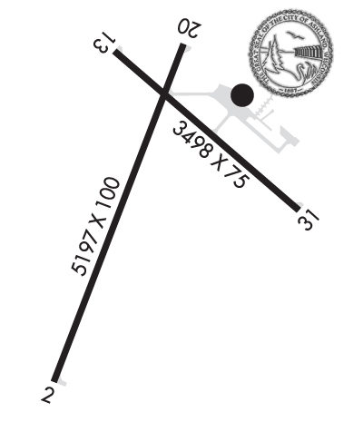
| Lat: N 4632.9 Long: W 09055.1 Elev: 827 Var: +02 Longest Runway: 5197 | ||
| AWOS: 126.77 CTAF: 122.8 | ||
| ||||||||||||||||||||||||||||||||||||||||||||
| ||||||||||||||||||||||||||||||||||||||||||||
| ||||||||||||||||||||||||||||||||||||||||||||
| Rwy | Rwy | |||||||
| 5197x100 | 5197' | 109.30 - 022° | 5197x100 | 5197' | ||||
| 3498x75 | 3498' | 3498x75 | 3498' | |||||
| Runway ID | Single Wheel | Double Wheel | Double Tandem Wheel | Dual Double Wheel |
| 02/20 | 42,000 | 52,000 | N/A | N/A |
| 13/31 | 40,000 | 50,000 | N/A | N/A |
| These numbers are Advisory and are not limits. The Airport Manager should have more accurate Weight Limits | ||||
 Airport Diagram might not be current. | |
| Facility Name: | JOHN F KENNEDY MEML |
| City Name: | ASHLAND |
| County: | ASHLAND |
| State abbrev: | WI |
| State Name: | WISCONSIN |
| Ownership: | PUBLICLY OWNED |
| Use: | OPEN TO THE PUBLIC |
| Owner's Name: | COUNTY & CITY OF ASHLAND |
| Address: | |
| ASHLAND, WI 54806 | |
| Owner's Phone: | 715-682-7070 |
| Manager's Name: | BILL MOORE |
| Address: | 50511 STATE HIGHWAY 112 |
| ASHLAND, WI 54806 | |
| Phone: | 715-682-7070 |
| FAA Region: | GREAT LAKES |
| FAA Field Office: | CHI |
| Date | Sunrise | Sunset |
|---|---|---|
| 09/24/21 Friday | 6:53 | 18:58 |
| 09/25/21 Saturday | 6:54 | 18:56 |
| 09/26/21 Sunday | 6:55 | 18:54 |
| 09/27/21 Monday | 6:57 | 18:52 |
| 09/28/21 Tuesday | 6:58 | 18:50 |
| 09/29/21 Wednesday | 6:59 | 18:48 |
| 09/30/21 Thursday | 7:01 | 18:46 |
| 10/01/21 Friday | 7:02 | 18:44 |
| 10/02/21 Saturday | 7:03 | 18:42 |
| 10/03/21 Sunday | 7:05 | 18:40 |
| 10/04/21 Monday | 7:06 | 18:38 |
| 10/05/21 Tuesday | 7:07 | 18:36 |
| 10/06/21 Wednesday | 7:09 | 18:34 |
| 10/07/21 Thursday | 7:10 | 18:32 |
| Airport Attendance Schedule | MON-FRI 0800-1600; FOR SVC AFTER HRS CALL 715-292-7070. |
| Airport Status | OPERATIONAL (This Status can change at any time - please check NOTAMS) |
| Airport Lighting Schedule | MIRL RY 02/20 PRESET LOW INTENSITY; TO INCREASE INTENSITY AND ACTVT REIL RY 02; PAPI RY 02/20; MIRL RY 02/20; PAPI RY 31; MIRL RY 13/31 - CTAF. |
| Airport Storage Available | Tie Downs, Hanger |
| Extra Services Available | Flight Instruction |
| Wind Indicator | YES - (lighted) |
| Control Tower | NO |
| CTAF Frequency | 122.800 |
| Unicom Frequency | 122.800 |
| Rotating Beacon Color | CLEAR-GREEN (Light Land Airport) |
| Segmented Circle | NO |
| Landing Fee | NO |
| Airport Inspected | STATE - performed by STATE AERONAUTICAL PERSONNEL |
| Inspection Date | 08/15/2019 |
| Type of Fuel Available | Grade 100LL, JET A; -10JET A+ PPR CTC AMGR 715-682-7070, AFT HRS CALL 715-292-7070. 24 HR SELF SERVE 100LL. |
| Airframe Repair Service | NONE |
| Power Plant Repair Service | NONE |
| Latitude | N4632.9 |
| Longitude | W09055.1 (ESTIMATED) |
| Arpt Elevation | 826ft (SURVEYED) |
| Magnetic Variation | 02W |
| 2 miles SW | of ASHLAND |
| Traffic Pattern Altitude | |
| Sectional Chart | GREEN BAY |
| Operations (Reported) | Yearly | Avg. Daily |
|---|---|---|
| General Aviation Transient | 5000 | 14 |
| General Aviation Local | 5000 | 14 |
| Air Taxi | 500 | 1 |
| Commerical | 0 | 0 |
| Commuter | 0 | 0 |
| Military | 25 | 0 |
| Aircraft based on Field | |
|---|---|
| General Aviation Singles | 19 |
| General Aviation Multi | 1 |
| Jet Aircraft | 1 |
| General Aviation Helicopters | 0 |
| Military Aircraft | 0 |
| Gliders | 0 |
| Ultralights | 0 |
| FSS on field | NO |
| FSS tie-in | GREEN BAY |
| FSS Phone | 1-800-WX-BRIEF |
| Who issues Notams | ASX |
| Notam D service at airport | YES |
| ARTCC Name | MINNEAPOLIS |
| Airport Certification | |
| Aircraft Rescue & Firefighting Index | None |
| Airport of Entry | No |
| Custom Landing Rights | No |
| Joint Civil/Military | No |
| Military Landing rights | YES |
| NATIONAL PLAN OF INTEGRATED AIRPORT SYSTEMS (NPIAS) |
| GRANT AGREEMENTS UNDER FAAP/ADAP/AIP |
| ASSURANCES PURSUANT TO TITLE VI, CIVIL RIGHTS ACT OF 1964 |
| THIS AIRPORT HAS BEEN SURVEYED BY THE NATIONAL GEODETIC SURVEY. |
| DEER & OTR WILDLIFE ON & INVOF ARPT. HVY BIRD ACT SPRING & SUMMER MONTHS. |
| ACFT OVER 4000 LBS MUST STOP OR PARK ON CONC; ALL OTR ACFT PARK ON ASPH. |
| GCO AVBL ON FREQ 122.25 THRU FLT SVCS. |
| FOR CD IF UNA TO CTC ON FSS FREQ, CTC MINNEAPOLIS ARTCC AT 651-463-5588. |
Airport Communications & Frequencies:
| |||||||||
| Runway: 02 | Runway: 20 | ||
| Mag heading: | 23° | Mag heading: | 203° |
| Rwy Slope: | .08% Up | Rwy Slope: | -.08% Down |
| Approach: | LOC/DME | Approach: | |
| Pattern: | Left Traffic | Pattern: | Left Traffic |
| Markings: | NONPRECISION INSTRUMENT | Markings: | NONPRECISION INSTRUMENT |
| Marking Condition: | GOOD | Marking Condition: | GOOD |
| Arresting Dev: | Arresting Dev: | ||
| Lat & Long: | N4632.4 W09055.5 | Lat. & Long.: | N4633.2 W09055.0 |
| Elev: | 818.9 ft. MSL | Elev: | 823.2 ft. MSL |
| TCH: | 41 ft. AGL | TCH: | 34 ft. AGL |
| Visual Glide Path: | 3.00 degrees | Visual Glide Path: | 3.00 degrees |
| Displaced Threshold: | No | Displaced Threshold: | No |
| Touchdown Zone: | YES | Touchdown Zone: | YES |
| Touchdown Elev.: | 825.8 feet | Touchdown Elev.: | 826.5 feet |
| Visual Glide Slope: | 4-Light PAPI on LEFT side of Runway | Visual Glide Slope: | 4-Light PAPI on LEFT side of Runway |
| RVR Equipment: | RVR Equipment: | ||
| RVV Equipment: | NO | RVV Equipment: | NO |
| Approach Lights: | Approach Lights: | ||
| REIL: | YES | REIL: | NO |
| Centerline Lights: | NO | Centerline Lights: | NO |
| Touchdown lights: | NO | Touchdown lights: | NO |
| Runway Category: | Runway with a Non-precision Approach having visibility minimums greater than 3/4 mile | Runway Category: | Runway with a Non-precision Approach having visibility minimums greater than 3/4 mile |
| Declared Distances: | Declared Distances: | ||
| Obstructions: | TREES | Obstructions: | TREES |
| Marked: | NOT Marked/Lighted | Marked: | NOT Marked/Lighted |
| Clearance slope: | 28:1 | Clearance slope: | 28:1 |
| Obstruction height: | 63 feet AGL | Obstruction height: | 72 feet AGL |
| Dist. from runway: | 1960 feet | Dist. from runway: | 2210 feet |
| Centerline offset: | 300 right of centerline | Centerline offset: | |
| Comments: | Comments: |
| Runway: 13 | Runway: 31 | ||
| Mag heading: | 133° | Mag heading: | 313° |
| Rwy Slope: | -.41% Down | Rwy Slope: | .41% Up |
| Approach: | Approach: | ||
| Pattern: | Left Traffic | Pattern: | Left Traffic |
| Markings: | NONPRECISION INSTRUMENT | Markings: | NONPRECISION INSTRUMENT |
| Marking Condition: | FAIR | Marking Condition: | FAIR |
| Arresting Dev: | Arresting Dev: | ||
| Lat & Long: | N4633.2 W09055.3 | Lat. & Long.: | N4632.8 W09054.6 |
| Elev: | 824.1 ft. MSL | Elev: | 809.9 ft. MSL |
| TCH: | TCH: | 37 ft. AGL | |
| Visual Glide Path: | Visual Glide Path: | 3.00 degrees | |
| Displaced Threshold: | No | Displaced Threshold: | No |
| Touchdown Zone: | YES | Touchdown Zone: | YES |
| Touchdown Elev.: | 826.5 feet | Touchdown Elev.: | 826.5 feet |
| Visual Glide Slope: | Visual Glide Slope: | 2-Light PAPI on LEFT side of Runway | |
| RVR Equipment: | RVR Equipment: | ||
| RVV Equipment: | NO | RVV Equipment: | NO |
| Approach Lights: | Approach Lights: | ||
| REIL: | NO | REIL: | NO |
| Centerline Lights: | NO | Centerline Lights: | NO |
| Touchdown lights: | NO | Touchdown lights: | NO |
| Runway Category: | Runway with a Non-precision Approach | Runway Category: | Runway with a Non-precision Approach |
| Declared Distances: | Declared Distances: | ||
| Obstructions: | TREES | Obstructions: | TREES |
| Marked: | NOT Marked/Lighted | Marked: | NOT Marked/Lighted |
| Clearance slope: | 27:1 | Clearance slope: | 20:1 |
| Obstruction height: | 40 feet AGL | Obstruction height: | 45 feet AGL |
| Dist. from runway: | 1300 feet | Dist. from runway: | 1100 feet |
| Centerline offset: | 300 left of centerline | Centerline offset: | 300 feet right of centerline |
| Comments: | Comments: |
Thanks for using FltPlan.com
all rights reserved © 1999-2021 by Flight Plan LLC
