| WARSAW MUNI WARSAW IN |
| |
| Lat: N 4116.5 Long: W 08550.4 Elev: 850 Var: +03 Longest Runway: 6001 | ||
| Clr Del: 134.05 AWOS: 121.12 CTAF: 122.7 | ||
| |||||||||||||||||||||||||||||||||||||||||||||||||||||||||||||
| |||||||||||||||||||||||||||||||||||||||||||||||||||||||||||||
| |||||||||||||||||||||||||||||||||||||||||||||||||||||||||||||
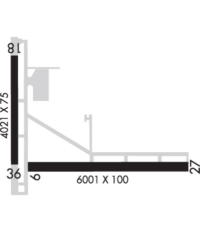
| Rwy | Rwy | |||||||
| 6001x100 | 6001' | 6001x100 | 5100' | 111.55 - 271° | ||||
| 4021x75 | 4021' | 4021x75 | 4021' | |||||
| Runway ID | Single Wheel | Double Wheel | Double Tandem Wheel | Dual Double Wheel |
| 09/27 | 46,000 | 75,000 | N/A | N/A |
| 18/36 | 15,000 | N/A | N/A | N/A |
| These numbers are Advisory and are not limits. The Airport Manager should have more accurate Weight Limits | ||||
 Airport Diagram might not be current. | |
| Facility Name: | WARSAW MUNI |
| City Name: | WARSAW |
| County: | KOSCIUSKO |
| State abbrev: | IN |
| State Name: | INDIANA |
| Ownership: | PUBLICLY OWNED |
| Use: | OPEN TO THE PUBLIC |
| Owner's Name: | WARSAW BOAC |
| Address: | 3000 AIRPORT DR |
| WARSAW, IN 46582 | |
| Owner's Phone: | 574-269-1337 |
| Manager's Name: | NICHOLAS KING |
| Address: | 3000 AIRPORT DR |
| WARSAW, IN 46582 | |
| Phone: | 574-269-1337 |
| FAA Region: | GREAT LAKES |
| FAA Field Office: | CHI |
| Date | Sunrise | Sunset |
|---|---|---|
| 06/08/26 Monday | 6:10 | 21:15 |
| 06/09/26 Tuesday | 6:10 | 21:15 |
| 06/10/26 Wednesday | 6:10 | 21:16 |
| 06/11/26 Thursday | 6:10 | 21:16 |
| 06/12/26 Friday | 6:10 | 21:17 |
| 06/13/26 Saturday | 6:10 | 21:17 |
| 06/14/26 Sunday | 6:10 | 21:18 |
| 06/15/26 Monday | 6:10 | 21:18 |
| 06/16/26 Tuesday | 6:10 | 21:18 |
| 06/17/26 Wednesday | 6:10 | 21:19 |
| 06/18/26 Thursday | 6:10 | 21:19 |
| 06/19/26 Friday | 6:10 | 21:19 |
| 06/20/26 Saturday | 6:10 | 21:20 |
| 06/21/26 Sunday | 6:10 | 21:20 |
| Airport Attendance Schedule | MON-FRI 0700-1900, SAT-SUN 0800-1800; AFT HR - 574-372-9541 |
| Airport Status | OPERATIONAL (This Status can change at any time - please check NOTAMS) |
| Airport Lighting Schedule | ACTVT REIL RWY 09 & 27; PAPI RWY 09 & 27; MIRL RWY 18/36 - CTAF. VASI RWY 18 OPR CONSLY. HIRL RWY 09/27 PRESET TO LOW INTST; INCR INTST - CTAF. |
| Airport Storage Available | Tie Downs, Hanger |
| Extra Services Available | Air Freight, Charter, Flight Instruction, Aircraft Rental |
| Wind Indicator | YES - (lighted) |
| Control Tower | NO |
| CTAF Frequency | 122.700 |
| Unicom Frequency | 122.700 |
| Rotating Beacon Color | WG |
| Segmented Circle | YES |
| Landing Fee | NO |
| Airport Inspected | STATE - performed by STATE AERONAUTICAL PERSONNEL |
| Inspection Date | 07/05/2022 |
| Type of Fuel Available | Grade 100LL, JET A (freeze point -40C) |
| Airframe Repair Service | MAJOR |
| Power Plant Repair Service | MAJOR |
| Latitude | N4116.5 |
| Longitude | W08550.4 (ESTIMATED) |
| Arpt Elevation | 849ft (SURVEYED) |
| Magnetic Variation | 03W |
| 2 miles N | of WARSAW |
| Traffic Pattern Altitude | |
| Sectional Chart | CHICAGO |
| Operations (Reported) | Yearly | Avg. Daily |
|---|---|---|
| General Aviation Transient | 0 | 0 |
| General Aviation Local | 0 | 0 |
| Air Taxi | 0 | 0 |
| Commerical | 0 | 0 |
| Commuter | 0 | 0 |
| Military | 0 | 0 |
| Aircraft based on Field | |
|---|---|
| General Aviation Singles | 0 |
| General Aviation Multi | 0 |
| Jet Aircraft | 0 |
| General Aviation Helicopters | 0 |
| Military Aircraft | 0 |
| Gliders | 0 |
| Ultralights | 0 |
| FSS on field | NO |
| FSS tie-in | TERRE HAUTE |
| FSS Phone | 1-800-WX-BRIEF |
| Who issues Notams | ASW |
| Notam D service at airport | YES |
| ARTCC Name | CHICAGO |
| Airport Certification | |
| Aircraft Rescue & Firefighting Index | None |
| Airport of Entry | No |
| Custom Landing Rights | No |
| Joint Civil/Military | No |
| Military Landing rights | YES |
| NATIONAL PLAN OF INTEGRATED AIRPORT SYSTEMS (NPIAS) |
| GRANT AGREEMENTS UNDER FAAP/ADAP/AIP |
| ASSURANCES PURSUANT TO TITLE VI, CIVIL RIGHTS ACT OF 1964 |
| FOR CD CTC CHICAGO ARTCC AT 630-906-8921. |
Airport Communications & Frequencies:
| |||||||||||||||||||
| Runway: 09 | Runway: 27 | ||
| Mag heading: | 92° | Mag heading: | 272° |
| Rwy Slope: | .20% Up | Rwy Slope: | -.20% Down |
| Approach: | Approach: | ILS/DME | |
| Pattern: | Left Traffic | Pattern: | Left Traffic |
| Markings: | NONPRECISION INSTRUMENT | Markings: | PRECISION INSTRUMENT |
| Marking Condition: | FAIR | Marking Condition: | FAIR |
| Arresting Dev: | Arresting Dev: | ||
| Lat & Long: | N4116.3 W08550.8 | Lat. & Long.: | N4116.4 W08549.5 |
| Elev: | 837.4 ft. MSL | Elev: | 849.5 ft. MSL |
| TCH: | 27 ft. AGL | TCH: | 54 ft. AGL |
| Visual Glide Path: | 3.00 degrees | Visual Glide Path: | 3.00 degrees |
| Displaced Threshold: | No | Displaced Threshold: | 901 feet |
| Touchdown Zone: | YES | Touchdown Zone: | YES |
| Touchdown Elev.: | 845.0 feet | Touchdown Elev.: | 846.9 feet |
| Visual Glide Slope: | 2-Light PAPI on LEFT side of Runway | Visual Glide Slope: | 4-Light PAPI on LEFT side of Runway |
| RVR Equipment: | RVR Equipment: | ||
| RVV Equipment: | NO | RVV Equipment: | NO |
| Approach Lights: | Approach Lights: | ||
| REIL: | YES | REIL: | YES |
| Centerline Lights: | NO | Centerline Lights: | NO |
| Touchdown lights: | NO | Touchdown lights: | NO |
| Runway Category: | Runway with a Non-precision Approach having visibility minimums greater than 3/4 mile | Runway Category: | Precision Instrument Runway |
| Declared Distances: | TORA:5100' TODA:5100' ASDA:5100' LDA:5100' | Declared Distances: | TORA:6000' TODA:6000' ASDA:6000' LDA:5100' |
| Obstructions: | POLE | Obstructions: | TOWER |
| Marked: | NOT Marked/Lighted | Marked: | LIGHTED |
| Clearance slope: | 30:1 | Clearance slope: | 32:1; APCH SLOPE 34:1 TO DTHR. |
| Obstruction height: | 41 feet AGL | Obstruction height: | 166 feet AGL |
| Dist. from runway: | 1460 feet | Dist. from runway: | 5600 feet |
| Centerline offset: | 10 right of centerline | Centerline offset: | 200 feet right of centerline; CLOSEST ESTD INTCP OF TALLEST TWR. |
| Comments: | Comments: | 6 FT FENCE 1045 FT FM RWY END; 15 FT ROAD 1070 FT FM RWY END. |
| Runway: 18 | Runway: 36 | ||
| Mag heading: | 182° | Mag heading: | 2° |
| Rwy Slope: | -.08% Down | Rwy Slope: | .08% Up |
| Approach: | Approach: | ||
| Pattern: | Left Traffic | Pattern: | Left Traffic |
| Markings: | NONPRECISION INSTRUMENT | Markings: | NONPRECISION INSTRUMENT |
| Marking Condition: | FAIR | Marking Condition: | FAIR |
| Arresting Dev: | Arresting Dev: | ||
| Lat & Long: | N4117.0 W08550.8 | Lat. & Long.: | N4116.3 W08550.8 |
| Elev: | 839.7 ft. MSL | Elev: | 836.5 ft. MSL |
| TCH: | 35 ft. AGL | TCH: | |
| Visual Glide Path: | 3.50 degrees | Visual Glide Path: | |
| Displaced Threshold: | No | Displaced Threshold: | No |
| Touchdown Zone: | YES | Touchdown Zone: | YES |
| Touchdown Elev.: | 840.7 feet | Touchdown Elev.: | 840.7 feet |
| Visual Glide Slope: | 4-BOX VASI ON LEFT SIDE OF RUNWAY | Visual Glide Slope: | |
| RVR Equipment: | RVR Equipment: | ||
| RVV Equipment: | NO | RVV Equipment: | NO |
| Approach Lights: | Approach Lights: | ||
| REIL: | NO | REIL: | NO |
| Centerline Lights: | NO | Centerline Lights: | NO |
| Touchdown lights: | NO | Touchdown lights: | NO |
| Runway Category: | Runway with a Visual Approach | Runway Category: | Runway with a Visual Approach |
| Declared Distances: | Declared Distances: | ||
| Obstructions: | ROAD | Obstructions: | TREE |
| Marked: | NOT Marked/Lighted | Marked: | NOT Marked/Lighted |
| Clearance slope: | 19:1 | Clearance slope: | 28:1 |
| Obstruction height: | 15 feet AGL | Obstruction height: | 28 feet AGL |
| Dist. from runway: | 495 feet | Dist. from runway: | 1000 feet |
| Centerline offset: | Centerline offset: | 165 feet left of centerline | |
| Comments: | Comments: |
Thanks for using FltPlan.com
all rights reserved © 1999-2026 by Flight Plan LLC