
| HARRISON COUNTY MARSHALL TX |
| |
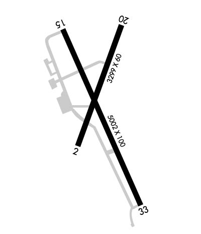
| Lat: N 3231.2 Long: W 09418.5 Elev: 357 Var: -03 Longest Runway: 5002 | ||
| AWOS: 118.67 CTAF: 122.8 | ||
| ||||||||||||||||||||||||||||||||||||||||||||
| ||||||||||||||||||||||||||||||||||||||||||||
| ||||||||||||||||||||||||||||||||||||||||||||
| Rwy | Rwy | |||||||
| 3304x60 | 3304' | 3304x60 | 3304' | |||||
| 5002x100 | 5002' | 5002x100 | 5002' | |||||
| Runway ID | Single Wheel | Double Wheel | Double Tandem Wheel | Dual Double Wheel |
| 02/20 | 20,000 | N/A | N/A | N/A |
| 15/33 | 20,000 | N/A | N/A | N/A |
| These numbers are Advisory and are not limits. The Airport Manager should have more accurate Weight Limits | ||||
 Airport Diagram might not be current. | |
| Facility Name: | HARRISON COUNTY |
| City Name: | MARSHALL |
| County: | HARRISON |
| State abbrev: | TX |
| State Name: | TEXAS |
| Ownership: | PUBLICLY OWNED |
| Use: | OPEN TO THE PUBLIC |
| Owner's Name: | HARRISON COUNTY |
| Address: | COUNTY COURTHOUSE, 200 WEST HOUSTON |
| MARSHALL, TX 75670 | |
| Owner's Phone: | 903-935-8401 |
| Manager's Name: | DANIEL AIELLO |
| Address: | 2100 WARREN DR. |
| MARSHALL, TX 75672 | |
| Phone: | 903-938-1394; OR 903-938-8008. |
| FAA Region: | SOUTHWEST |
| FAA Field Office: | TEX |
| Date | Sunrise | Sunset |
|---|---|---|
| 06/07/26 Sunday | 6:10 | 20:23 |
| 06/08/26 Monday | 6:09 | 20:23 |
| 06/09/26 Tuesday | 6:09 | 20:24 |
| 06/10/26 Wednesday | 6:09 | 20:24 |
| 06/11/26 Thursday | 6:09 | 20:25 |
| 06/12/26 Friday | 6:09 | 20:25 |
| 06/13/26 Saturday | 6:09 | 20:25 |
| 06/14/26 Sunday | 6:09 | 20:26 |
| 06/15/26 Monday | 6:09 | 20:26 |
| 06/16/26 Tuesday | 6:09 | 20:26 |
| 06/17/26 Wednesday | 6:10 | 20:27 |
| 06/18/26 Thursday | 6:10 | 20:27 |
| 06/19/26 Friday | 6:10 | 20:27 |
| 06/20/26 Saturday | 6:10 | 20:27 |
| Airport Attendance Schedule | MON-SAT 0800-1700, SUN IREG; FOR ARPT ATTENDANT ON SUN CALL 903-938-1394. |
| Airport Status | OPERATIONAL (This Status can change at any time - please check NOTAMS) |
| Airport Lighting Schedule | MIRL RWY 15/33 PRESET LOW INTST; TO INCR INTST & ACTVT REIL RWY 15 & 33 - CTAF. |
| Airport Storage Available | Tie Downs, Hanger |
| Extra Services Available | Flight Instruction, Aircraft Rental, Aircraft Sales |
| Wind Indicator | YES - (lighted) |
| Control Tower | NO |
| CTAF Frequency | 122.800 |
| Unicom Frequency | 122.800 |
| Rotating Beacon Color | WG |
| Segmented Circle | YES |
| Landing Fee | NO |
| Airport Inspected | STATE - performed by PRIVATE CONTRACT PERSONNEL |
| Inspection Date | 05/05/2025 |
| Type of Fuel Available | Grade 100LL, JET A (freeze point -40C) |
| Airframe Repair Service | MAJOR |
| Power Plant Repair Service | MAJOR |
| Latitude | N3231.2 |
| Longitude | W09418.5 (ESTIMATED) |
| Arpt Elevation | 357ft (SURVEYED) |
| Magnetic Variation | 03E |
| 3 miles SE | of MARSHALL |
| Traffic Pattern Altitude | |
| Sectional Chart | MEMPHIS |
| Operations (Reported) | Yearly | Avg. Daily |
|---|---|---|
| General Aviation Transient | 0 | 0 |
| General Aviation Local | 0 | 0 |
| Air Taxi | 0 | 0 |
| Commerical | 0 | 0 |
| Commuter | 0 | 0 |
| Military | 0 | 0 |
| Aircraft based on Field | |
|---|---|
| General Aviation Singles | 0 |
| General Aviation Multi | 0 |
| Jet Aircraft | 0 |
| General Aviation Helicopters | 0 |
| Military Aircraft | 0 |
| Gliders | 0 |
| Ultralights | 0 |
| FSS on field | NO |
| FSS tie-in | FORT WORTH |
| FSS Phone | 1-800-WX-BRIEF |
| Who issues Notams | FTW |
| Notam D service at airport | YES |
| ARTCC Name | FORT WORTH |
| Airport Certification | |
| Aircraft Rescue & Firefighting Index | None |
| Airport of Entry | No |
| Custom Landing Rights | No |
| Joint Civil/Military | No |
| Military Landing rights | YES |
| NATIONAL PLAN OF INTEGRATED AIRPORT SYSTEMS (NPIAS) |
| GRANT AGREEMENTS UNDER FAAP/ADAP/AIP |
| ASSURANCES PURSUANT TO TITLE VI, CIVIL RIGHTS ACT OF 1964 |
| FOR CD CTC FORT WORTH ARTCC AT 817-858-7584. |
Airport Communications & Frequencies:
| ||||||||||||||
| Runway: 02 | Runway: 20 | ||
| Mag heading: | 19° | Mag heading: | 199° |
| Rwy Slope: | .08% Up | Rwy Slope: | -.08% Down |
| Approach: | Approach: | ||
| Pattern: | Left Traffic | Pattern: | Left Traffic |
| Markings: | BASIC | Markings: | BASIC |
| Marking Condition: | GOOD | Marking Condition: | GOOD |
| Arresting Dev: | Arresting Dev: | ||
| Lat & Long: | N3231.1 W09418.6 | Lat. & Long.: | N3231.6 W09418.3 |
| Elev: | 338.3 ft. MSL | Elev: | 341.0 ft. MSL |
| TCH: | TCH: | ||
| Visual Glide Path: | Visual Glide Path: | ||
| Displaced Threshold: | No | Displaced Threshold: | No |
| Touchdown Zone: | YES | Touchdown Zone: | YES |
| Touchdown Elev.: | 349.2 feet | Touchdown Elev.: | 349.2 feet |
| Visual Glide Slope: | Visual Glide Slope: | ||
| RVR Equipment: | RVR Equipment: | ||
| RVV Equipment: | NO | RVV Equipment: | NO |
| Approach Lights: | Approach Lights: | ||
| REIL: | NO | REIL: | NO |
| Centerline Lights: | NO | Centerline Lights: | NO |
| Touchdown lights: | NO | Touchdown lights: | NO |
| Runway Category: | Runway with a Visual Approach | Runway Category: | Runway with a Visual Approach |
| Declared Distances: | Declared Distances: | ||
| Obstructions: | TREES | Obstructions: | TREES |
| Marked: | NOT Marked/Lighted | Marked: | NOT Marked/Lighted |
| Clearance slope: | 15:1 | Clearance slope: | 4:1 |
| Obstruction height: | 81 feet AGL | Obstruction height: | 46 feet AGL |
| Dist. from runway: | 1436 feet | Dist. from runway: | 397 feet |
| Centerline offset: | 245 right of centerline | Centerline offset: | 155 feet right of centerline |
| Comments: | Comments: |
| Runway: 15 | Runway: 33 | ||
| Mag heading: | 154° | Mag heading: | 334° |
| Rwy Slope: | -.73% Down | Rwy Slope: | .73% Up |
| Approach: | Approach: | ||
| Pattern: | Left Traffic | Pattern: | Left Traffic |
| Markings: | NONPRECISION INSTRUMENT | Markings: | NONPRECISION INSTRUMENT |
| Marking Condition: | GOOD | Marking Condition: | GOOD |
| Arresting Dev: | Arresting Dev: | ||
| Lat & Long: | N3231.6 W09418.7 | Lat. & Long.: | N3230.8 W09418.3 |
| Elev: | 356.0 ft. MSL | Elev: | 319.7 ft. MSL |
| TCH: | TCH: | ||
| Visual Glide Path: | Visual Glide Path: | ||
| Displaced Threshold: | No | Displaced Threshold: | No |
| Touchdown Zone: | YES | Touchdown Zone: | YES |
| Touchdown Elev.: | 357.1 feet | Touchdown Elev.: | 349.0 feet |
| Visual Glide Slope: | Visual Glide Slope: | ||
| RVR Equipment: | RVR Equipment: | ||
| RVV Equipment: | NO | RVV Equipment: | NO |
| Approach Lights: | Approach Lights: | ||
| REIL: | YES | REIL: | YES |
| Centerline Lights: | NO | Centerline Lights: | NO |
| Touchdown lights: | NO | Touchdown lights: | NO |
| Runway Category: | Runway with a Non-precision Approach having visibility minimums greater than 3/4 mile | Runway Category: | Runway with a Non-precision Approach having visibility minimums greater than 3/4 mile |
| Declared Distances: | Declared Distances: | ||
| Obstructions: | FENCE | Obstructions: | TREES |
| Marked: | NOT Marked/Lighted | Marked: | NOT Marked/Lighted |
| Clearance slope: | 4:1 | Clearance slope: | 15:1 |
| Obstruction height: | 7 feet AGL | Obstruction height: | 45 feet AGL |
| Dist. from runway: | 228 feet | Dist. from runway: | 900 feet |
| Centerline offset: | 250 left of centerline | Centerline offset: | 315 feet left of centerline |
| Comments: | Comments: |
Thanks for using FltPlan.com
all rights reserved © 1999-2026 by Flight Plan LLC
