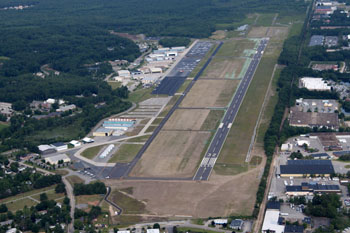
| BOIRE FIELD NASHUA NH |
| |
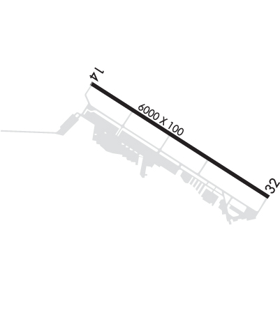
| Lat: N 4246.9 Long: W 07130.8 Elev: 200 Var: +16 Longest Runway: 6000 | ||
| Clr Del: 121.8 Dept. ATIS: 125.1 Arr. ATIS: 125.1 AWOS: 125.1 Ground: 121.8 Tower: 133.2 | ||
| |||||||||||||||||||||||||||||||||||||||||||||||||||||||||||||||||||||
| |||||||||||||||||||||||||||||||||||||||||||||||||||||||||||||||||||||
| |||||||||||||||||||||||||||||||||||||||||||||||||||||||||||||||||||||
| |||||||||||||||||||||||||||||||||||||||||||||||||||||||||||||||||||||
| Rwy | Rwy | |||||||
| 6000x100 | 6000' | 109.70 - 139° | 6000x100 | 5650' | ||||
| Runway ID | Single Wheel | Double Wheel | Double Tandem Wheel | Dual Double Wheel |
| 14/32 | 62,000 | 80,000 | 133,000 | N/A |
| These numbers are Advisory and are not limits. The Airport Manager should have more accurate Weight Limits | ||||
 Airport Diagram might not be current. | |
| Facility Name: | BOIRE FLD |
| City Name: | NASHUA |
| County: | HILLSBOROUGH |
| State abbrev: | NH |
| State Name: | NEW HAMPSHIRE |
| Ownership: | PUBLICLY OWNED |
| Use: | OPEN TO THE PUBLIC |
| Owner's Name: | NASHUA AIRPORT AUTHORITY |
| Address: | 93 PERIMETER RD |
| NASHUA, NH 03063 | |
| Owner's Phone: | 603-882-0661 |
| Manager's Name: | CHRIS LYNCH |
| Address: | 93 PERIMETER RD |
| NASHUA, NH 03063 | |
| Phone: | 603-882-0661 |
| FAA Region: | NEW ENGLAND |
| FAA Field Office: | NONE |
| Date | Sunrise | Sunset |
|---|---|---|
| 06/08/26 Monday | 5:08 | 20:22 |
| 06/09/26 Tuesday | 5:08 | 20:23 |
| 06/10/26 Wednesday | 5:07 | 20:24 |
| 06/11/26 Thursday | 5:07 | 20:24 |
| 06/12/26 Friday | 5:07 | 20:25 |
| 06/13/26 Saturday | 5:07 | 20:25 |
| 06/14/26 Sunday | 5:07 | 20:26 |
| 06/15/26 Monday | 5:07 | 20:26 |
| 06/16/26 Tuesday | 5:07 | 20:26 |
| 06/17/26 Wednesday | 5:07 | 20:27 |
| 06/18/26 Thursday | 5:07 | 20:27 |
| 06/19/26 Friday | 5:07 | 20:27 |
| 06/20/26 Saturday | 5:07 | 20:28 |
| 06/21/26 Sunday | 5:08 | 20:28 |
| Airport Attendance Schedule | 7 Days A Week 0700-2100 |
| Airport Status | OPERATIONAL (This Status can change at any time - please check NOTAMS) |
| Airport Lighting Schedule | WHEN TWR CLSD ACTVT MALSR RWY 14; REIL RWY 32; PAPI RWY 14; HIRL RWY 14/32 - CTAF. |
| Airport Storage Available | Tie Downs, Hanger |
| Extra Services Available | Charter, Flight Instruction, Aircraft Rental, Aircraft Sales |
| Wind Indicator | YES - (lighted) |
| Control Tower | YES |
| CTAF Frequency | 133.200 |
| Unicom Frequency | |
| Rotating Beacon Color | WG |
| Segmented Circle | NO |
| Landing Fee | NO; FOR ACFT OVR 12500 LBS, FEE PER 1000 LBS. |
| Airport Inspected | STATE - performed by STATE AERONAUTICAL PERSONNEL |
| Inspection Date | 08/30/2024 |
| Type of Fuel Available | Grade 100LL, JET A-1 (icing inhibitor, freeze point -50C) |
| Airframe Repair Service | MAJOR |
| Power Plant Repair Service | MAJOR |
| Latitude | N4246.9 |
| Longitude | W07130.8 (ESTIMATED) |
| Arpt Elevation | 200ft (SURVEYED) |
| Magnetic Variation | 16W |
| 3 miles NW | of NASHUA |
| Traffic Pattern Altitude | |
| Sectional Chart | NEW YORK |
| Operations (Reported) | Yearly | Avg. Daily |
|---|---|---|
| General Aviation Transient | 0 | 0 |
| General Aviation Local | 0 | 0 |
| Air Taxi | 0 | 0 |
| Commerical | 0 | 0 |
| Commuter | 0 | 0 |
| Military | 0 | 0 |
| Aircraft based on Field | |
|---|---|
| General Aviation Singles | 0 |
| General Aviation Multi | 0 |
| Jet Aircraft | 0 |
| General Aviation Helicopters | 0 |
| Military Aircraft | 0 |
| Gliders | 0 |
| Ultralights | 0 |
| FSS on field | NO |
| FSS tie-in | BANGOR |
| FSS Phone | 1-800-WX-BRIEF |
| Who issues Notams | ASH |
| Notam D service at airport | YES |
| ARTCC Name | BOSTON |
| Airport Certification | |
| Aircraft Rescue & Firefighting Index | None |
| Airport of Entry | No |
| Custom Landing Rights | No |
| Joint Civil/Military | No |
| Military Landing rights | YES |
| NATIONAL PLAN OF INTEGRATED AIRPORT SYSTEMS (NPIAS) |
| GRANT AGREEMENTS UNDER FAAP/ADAP/AIP |
| ASSURANCES PURSUANT TO TITLE VI, CIVIL RIGHTS ACT OF 1964 |
| ARPT HAS VOLUNTARY NOISE ABATEMENT PROCS. CTC AMGR FOR DETAILS. |
| MIGRATORY BIRDS & WILDLIFE ON & INVOF ARPT. |
| RAMP BTN TWY D & TWY E CLSD TO ACFT WITH WINGSPAN GTR THAN 48 FT UNLESS AUZD BY ATCT. |
Airport Communications & Frequencies:
| |||||||||||||||||||||||||
| Runway: 14 | Runway: 32 | ||
| Mag heading: | 139° | Mag heading: | 319° |
| Rwy Slope: | -.14% Down | Rwy Slope: | .14% Up |
| Approach: | ILS | Approach: | |
| Pattern: | Left Traffic | Pattern: | Left Traffic |
| Markings: | PRECISION INSTRUMENT | Markings: | NONPRECISION INSTRUMENT |
| Marking Condition: | GOOD | Marking Condition: | GOOD |
| Arresting Dev: | Arresting Dev: | ||
| Lat & Long: | N4247.2 W07131.4 | Lat. & Long.: | N4246.7 W07130.3 |
| Elev: | 200.4 ft. MSL | Elev: | 192.0 ft. MSL |
| TCH: | 45 ft. AGL | TCH: | 45 ft. AGL |
| Visual Glide Path: | 3.00 degrees | Visual Glide Path: | 3.00 degrees |
| Displaced Threshold: | No | Displaced Threshold: | 350 feet |
| Touchdown Zone: | YES | Touchdown Zone: | YES |
| Touchdown Elev.: | 200.4 feet | Touchdown Elev.: | 192.5 feet |
| Visual Glide Slope: | 4-Light PAPI on RIGHT side of Runway | Visual Glide Slope: | 4-Light PAPI on LEFT side of Runway |
| RVR Equipment: | RVR Equipment: | ||
| RVV Equipment: | NO | RVV Equipment: | NO |
| Approach Lights: | MALSR - 1,400 foot medium intensity approach lighting system with runway alignment indicator lights | Approach Lights: | |
| REIL: | NO | REIL: | YES |
| Centerline Lights: | NO | Centerline Lights: | NO |
| Touchdown lights: | NO | Touchdown lights: | NO |
| Runway Category: | Precision Instrument Runway | Runway Category: | Runway with a Non-precision Approach having visibility minimums greater than 3/4 mile |
| Declared Distances: | TORA:6000' TODA:6000' ASDA:5650' LDA:5650' | Declared Distances: | TORA:6000' TODA:6000' ASDA:6000' LDA:5650' |
| Obstructions: | POLE | Obstructions: | TREE |
| Marked: | LIGHTED | Marked: | NOT Marked/Lighted |
| Clearance slope: | 42:1 | Clearance slope: | 18:1; APCH SLOPE 44:1 TO DTHR. |
| Obstruction height: | 30 feet AGL | Obstruction height: | 63 feet AGL |
| Dist. from runway: | 1487 feet | Dist. from runway: | 1351 feet |
| Centerline offset: | 370 left of centerline; TREES LCTD ALG RAIL LN N OF RWY. | Centerline offset: | 287 feet left of centerline |
| Comments: | Comments: |
Thanks for using FltPlan.com
all rights reserved © 1999-2026 by Flight Plan LLC