
| LAKELAND/LEE MEMORIAL MINOCQUA-WOODRUFF WI |
| |
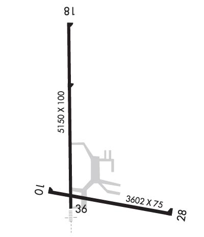
| Lat: N 4555.7 Long: W 08943.9 Elev: 1630 Var: +02 Longest Runway: 5150 | ||
| Clr Del: 122.6 RCO AWOS: 121.12 CTAF: 122.7 | ||
| ||||||||||||||||||||||||||||||||||||||||||||
| ||||||||||||||||||||||||||||||||||||||||||||
| ||||||||||||||||||||||||||||||||||||||||||||
| Rwy | Rwy | |||||||
| 3602x75 | 3602' | 3602x75 | 3602' | |||||
| 5150x100 | 5150' | 5150x100 | 5150' | 111.70 - 000° | ||||
| Runway ID | Single Wheel | Double Wheel | Double Tandem Wheel | Dual Double Wheel |
| 10/28 | 35,000 | N/A | N/A | N/A |
| 18/36 | 90,000 | 150,000 | N/A | N/A |
| These numbers are Advisory and are not limits. The Airport Manager should have more accurate Weight Limits | ||||
 Airport Diagram might not be current. | |
| Facility Name: | LAKELAND/NOBLE F LEE MEML FLD |
| City Name: | MINOCQUA-WOODRUFF |
| County: | VILAS |
| State abbrev: | WI |
| State Name: | WISCONSIN |
| Ownership: | PUBLICLY OWNED |
| Use: | OPEN TO THE PUBLIC |
| Owner's Name: | LAKELAND AIRPORT COMMISSION; TOWNS OF ARBOR VITAE, LAC DU FLAMBEAU, MINOCQUA, WOODRUFF. |
| Address: | 1545 N. FARMING RD. |
| WOODRUFF, WI 54568 | |
| Owner's Phone: | (715) 356-4340 |
| Manager's Name: | JESSE BIRGINAL |
| Address: | 1545 N. FARMING RD; EMAIL ADDRESS: LAKELANDAIRPORT@FRONTIER.COM (ALL LOWER CASE) |
| WOODRUFF, WI 54568 | |
| Phone: | (715) 356-3891 |
| FAA Region: | GREAT LAKES |
| FAA Field Office: | CHI |

| Date | Sunrise | Sunset |
|---|---|---|
| 02/11/26 Wednesday | 7:08 | 17:19 |
| 02/12/26 Thursday | 7:06 | 17:21 |
| 02/13/26 Friday | 7:05 | 17:22 |
| 02/14/26 Saturday | 7:03 | 17:24 |
| 02/15/26 Sunday | 7:02 | 17:25 |
| 02/16/26 Monday | 7:00 | 17:27 |
| 02/17/26 Tuesday | 6:59 | 17:28 |
| 02/18/26 Wednesday | 6:57 | 17:30 |
| 02/19/26 Thursday | 6:55 | 17:31 |
| 02/20/26 Friday | 6:54 | 17:32 |
| 02/21/26 Saturday | 6:52 | 17:34 |
| 02/22/26 Sunday | 6:50 | 17:35 |
| 02/23/26 Monday | 6:49 | 17:37 |
| 02/24/26 Tuesday | 6:47 | 17:38 |
| Airport Attendance Schedule | OCT-MAY 7 Days A Week 0800-1700, JUN-SEP 7 Days A Week 0800-1800; FOR ATTENDANT OTHER HRS CALL 715-490-4418. |
| Airport Status | OPERATIONAL (This Status can change at any time - please check NOTAMS) |
| Airport Lighting Schedule | HIRL RWY 18/36 PRESET TO LOW SS-SR; INCR INTST AND ACTVT MALSR RWY 36; REIL RWY 18 & 28; VASI RWY 18 & 36; PAPI RWY 28; MIRL RWY 10/28 - CTAF. |
| Airport Storage Available | Tie Downs, Hanger |
| Extra Services Available | Charter, Flight Instruction, Aircraft Rental |
| Wind Indicator | YES - (lighted) |
| Control Tower | NO |
| CTAF Frequency | 122.700 |
| Unicom Frequency | 122.700 |
| Rotating Beacon Color | WG |
| Segmented Circle | NO |
| Landing Fee | NO |
| Airport Inspected | STATE - performed by STATE AERONAUTICAL PERSONNEL |
| Inspection Date | 08/10/2023 |
| Type of Fuel Available | Grade 100LL, JET A-1 (icing inhibitor, freeze point -50C) |
| Airframe Repair Service | MINOR |
| Power Plant Repair Service | MINOR |
| Latitude | N4555.7 |
| Longitude | W08943.9 (ESTIMATED) |
| Arpt Elevation | 1629ft (SURVEYED) |
| Magnetic Variation | 02W |
| 3 miles NW | of MINOCQUA-WOODRUFF |
| Traffic Pattern Altitude | |
| Sectional Chart | GREEN BAY |
| Operations (Reported) | Yearly | Avg. Daily |
|---|---|---|
| General Aviation Transient | 0 | 0 |
| General Aviation Local | 0 | 0 |
| Air Taxi | 0 | 0 |
| Commerical | 0 | 0 |
| Commuter | 0 | 0 |
| Military | 0 | 0 |
| Aircraft based on Field | |
|---|---|
| General Aviation Singles | 0 |
| General Aviation Multi | 0 |
| Jet Aircraft | 0 |
| General Aviation Helicopters | 0 |
| Military Aircraft | 0 |
| Gliders | 0 |
| Ultralights | 0 |
| FSS on field | NO |
| FSS tie-in | GREEN BAY |
| FSS Phone | 1-800-WX-BRIEF |
| Who issues Notams | ARV |
| Notam D service at airport | YES |
| ARTCC Name | MINNEAPOLIS |
| Airport Certification | |
| Aircraft Rescue & Firefighting Index | None |
| Airport of Entry | No |
| Custom Landing Rights | No |
| Joint Civil/Military | No |
| Military Landing rights | YES |
| NATIONAL PLAN OF INTEGRATED AIRPORT SYSTEMS (NPIAS) |
| GRANT AGREEMENTS UNDER FAAP/ADAP/AIP |
| ASSURANCES PURSUANT TO TITLE VI, CIVIL RIGHTS ACT OF 1964 |
| SANDHILL CRANES ON & INVOF ARPT. |
| FOR CD IF UNA TO CTC ON FSS FREQ, CTC MINNEAPOLIS ARTCC AT 651-463-5588. |
| RWY 18/3 6 NSTD HIRL; NSTD THLD LGTS MALS TYPE THLD LGT BAR IN ADDITION TO STD LGTG. |
Airport Communications & Frequencies:
| |||||||||
| Runway: 10 | Runway: 28 | ||
| Mag heading: | 103° | Mag heading: | 283° |
| Rwy Slope: | .01% Up | Rwy Slope: | -.01% Down |
| Approach: | Approach: | ||
| Pattern: | Left Traffic | Pattern: | Left Traffic |
| Markings: | NONPRECISION INSTRUMENT | Markings: | NONPRECISION INSTRUMENT |
| Marking Condition: | GOOD | Marking Condition: | GOOD |
| Arresting Dev: | Arresting Dev: | ||
| Lat & Long: | N4555.5 W08944.1 | Lat. & Long.: | N4555.4 W08943.3 |
| Elev: | 1622.5 ft. MSL | Elev: | 1622.8 ft. MSL |
| TCH: | TCH: | 37 ft. AGL | |
| Visual Glide Path: | Visual Glide Path: | 3.00 degrees | |
| Displaced Threshold: | No | Displaced Threshold: | No |
| Touchdown Zone: | YES | Touchdown Zone: | YES |
| Touchdown Elev.: | 1624.5 feet | Touchdown Elev.: | 1624.5 feet |
| Visual Glide Slope: | Visual Glide Slope: | 2-Light PAPI on LEFT side of Runway | |
| RVR Equipment: | RVR Equipment: | ||
| RVV Equipment: | NO | RVV Equipment: | NO |
| Approach Lights: | Approach Lights: | ||
| REIL: | NO | REIL: | YES |
| Centerline Lights: | NO | Centerline Lights: | NO |
| Touchdown lights: | NO | Touchdown lights: | NO |
| Runway Category: | Runway with a Visual Approach | Runway Category: | Runway with a Non-precision Approach |
| Declared Distances: | Declared Distances: | ||
| Obstructions: | TREES | Obstructions: | |
| Marked: | NOT Marked/Lighted | Marked: | |
| Clearance slope: | 11:1 | Clearance slope: | 20:1 |
| Obstruction height: | 71 feet AGL | Obstruction height: | |
| Dist. from runway: | 1000 feet | Dist. from runway: | |
| Centerline offset: | 190 right of centerline | Centerline offset: | |
| Comments: | Comments: |
| Runway: 18 | Runway: 36 | ||
| Mag heading: | 181° | Mag heading: | 1° |
| Rwy Slope: | -.11% Down | Rwy Slope: | .11% Up |
| Approach: | Approach: | LOCALIZER | |
| Pattern: | Left Traffic | Pattern: | Left Traffic |
| Markings: | NONPRECISION INSTRUMENT | Markings: | NONPRECISION INSTRUMENT |
| Marking Condition: | FAIR | Marking Condition: | FAIR |
| Arresting Dev: | Arresting Dev: | ||
| Lat & Long: | N4556.3 W08944.0 | Lat. & Long.: | N4555.4 W08944.0 |
| Elev: | 1629.5 ft. MSL | Elev: | 1623.6 ft. MSL |
| TCH: | 44 ft. AGL | TCH: | 45 ft. AGL |
| Visual Glide Path: | 3.00 degrees | Visual Glide Path: | 3.00 degrees |
| Displaced Threshold: | No | Displaced Threshold: | No |
| Touchdown Zone: | YES | Touchdown Zone: | YES |
| Touchdown Elev.: | 1629.5 feet | Touchdown Elev.: | 1627.3 feet |
| Visual Glide Slope: | 4-BOX VASI ON LEFT SIDE OF RUNWAY | Visual Glide Slope: | 4-BOX VASI ON LEFT SIDE OF RUNWAY |
| RVR Equipment: | RVR Equipment: | ||
| RVV Equipment: | NO | RVV Equipment: | NO |
| Approach Lights: | Approach Lights: | MALSR - 1,400 foot medium intensity approach lighting system with runway alignment indicator lights | |
| REIL: | YES | REIL: | NO |
| Centerline Lights: | NO | Centerline Lights: | NO |
| Touchdown lights: | NO | Touchdown lights: | NO |
| Runway Category: | Runway with a Non-precision Approach having visibility minimums greater than 3/4 mile | Runway Category: | Runway with a Non-precision Approach having visibility minimums greater than 3/4 mile |
| Declared Distances: | Declared Distances: | ||
| Obstructions: | TREES | Obstructions: | |
| Marked: | NOT Marked/Lighted | Marked: | |
| Clearance slope: | 29:1 | Clearance slope: | 34:1 |
| Obstruction height: | 100 feet AGL | Obstruction height: | |
| Dist. from runway: | 3150 feet | Dist. from runway: | |
| Centerline offset: | 400 left of centerline | Centerline offset: | |
| Comments: | Comments: |
Thanks for using FltPlan.com
all rights reserved © 1999-2026 by Flight Plan LLC