| AURORA MUNI CHICAGO/AURORA IL |
| |
| Lat: N 4146.3 Long: W 08828.5 Elev: 712 Var: +01 Longest Runway: 6501 | ||
| Clr Del: 121.7 TW CLSD Dept. ATIS: 125.85 Arr. ATIS: 125.85 Ground: 121.7 Tower: 120.6 | ||
| |||||||||||||||||||||||||||||||||||||||||||||||||||||||||||||||||||||
| |||||||||||||||||||||||||||||||||||||||||||||||||||||||||||||||||||||
| |||||||||||||||||||||||||||||||||||||||||||||||||||||||||||||||||||||
| |||||||||||||||||||||||||||||||||||||||||||||||||||||||||||||||||||||
| |||||||||||||||||||||||||||||||||||||||||||||||||||||||||||||||||||||
| Rwy | Rwy | |||||||
| 6501x100 | 6501' | 108.90 - 090° | 6501x100 | 6501' | ||||
| 5503x100 | 5503' | 5503x100 | 5503' | 111.15 - 327° | ||||
| 3198x75 | 3198' | 3198x75 | 3198' | |||||
| Runway ID | Single Wheel | Double Wheel | Double Tandem Wheel | Dual Double Wheel |
| 09/27 | 30,000 | 130,000 | N/A | N/A |
| 15/33 | N/A | 130,000 | N/A | N/A |
| 18/36 | 30,000 | N/A | N/A | N/A |
| These numbers are Advisory and are not limits. The Airport Manager should have more accurate Weight Limits | ||||
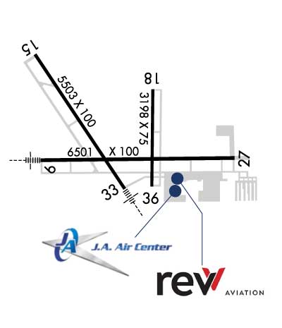 Airport Diagram might not be current. | |
| Facility Name: | AURORA MUNI |
| City Name: | CHICAGO/AURORA |
| County: | KANE |
| State abbrev: | IL |
| State Name: | ILLINOIS |
| Ownership: | PUBLICLY OWNED |
| Use: | OPEN TO THE PUBLIC |
| Owner's Name: | CITY OF AURORA |
| Address: | 44 E. DOWNER PLACE |
| AURORA, IL 60507 | |
| Owner's Phone: | (630) 256-3120 |
| Manager's Name: | STEVE ANDRAS |
| Address: | 43W 636 US30 |
| SUGAR GROVE, IL 60554 | |
| Phone: | (630) 256-3120 |
| FAA Region: | GREAT LAKES |
| FAA Field Office: | CHI |
| Date | Sunrise | Sunset |
|---|---|---|
| 09/24/21 Friday | 6:43 | 18:48 |
| 09/25/21 Saturday | 6:44 | 18:46 |
| 09/26/21 Sunday | 6:45 | 18:45 |
| 09/27/21 Monday | 6:46 | 18:43 |
| 09/28/21 Tuesday | 6:47 | 18:41 |
| 09/29/21 Wednesday | 6:48 | 18:39 |
| 09/30/21 Thursday | 6:49 | 18:38 |
| 10/01/21 Friday | 6:51 | 18:36 |
| 10/02/21 Saturday | 6:52 | 18:34 |
| 10/03/21 Sunday | 6:53 | 18:33 |
| 10/04/21 Monday | 6:54 | 18:31 |
| 10/05/21 Tuesday | 6:55 | 18:29 |
| 10/06/21 Wednesday | 6:56 | 18:28 |
| 10/07/21 Thursday | 6:57 | 18:26 |
| Airport Attendance Schedule | 7 Days A Week 0600-2400 |
| Airport Status | OPERATIONAL (This Status can change at any time - please check NOTAMS) |
| Airport Lighting Schedule | ACTVT MALSR RWY 09, 33; REIL RWY 18, 36,15, 27; TWY LGTS - CTAF. WHEN ATCT CLSD HIRL RWY 15/33, 09/27; MIRL RWY 18/36 PRESET LOW INTST, TO INCR INTST & ACTVT - CTAF. |
| Airport Storage Available | Tie Downs, Hanger |
| Extra Services Available | Air Freight, Avionics, Cargo Handling, Charter, Flight Instruction, Aircraft Rental, Aircraft Sales |
| Wind Indicator | YES - (lighted) |
| Control Tower | YES |
| CTAF Frequency | 120.600 |
| Unicom Frequency | 122.950; ADDNL UNICOM FREQ IS 123.50. |
| Rotating Beacon Color | CLEAR-GREEN (Light Land Airport) |
| Segmented Circle | NO |
| Landing Fee | NO |
| Airport Inspected | STATE - performed by STATE AERONAUTICAL PERSONNEL |
| Inspection Date | 09/10/2019 |
| Type of Fuel Available | Grade 100, JET A-1 (freeze point -50C) |
| Airframe Repair Service | MAJOR |
| Power Plant Repair Service | MAJOR |
| Latitude | N4146.3 |
| Longitude | W08828.5 (ESTIMATED) |
| Arpt Elevation | 712ft (SURVEYED) |
| Magnetic Variation | 01W |
| 38 miles W | of CHICAGO/AURORA |
| Traffic Pattern Altitude | |
| Sectional Chart | CHICAGO |
| Operations (Reported) | Yearly | Avg. Daily |
|---|---|---|
| General Aviation Transient | 30189 | 83 |
| General Aviation Local | 30305 | 83 |
| Air Taxi | 947 | 3 |
| Commerical | 28 | 0 |
| Commuter | 0 | 0 |
| Military | 603 | 2 |
| Aircraft based on Field | |
|---|---|
| General Aviation Singles | 144 |
| General Aviation Multi | 23 |
| Jet Aircraft | 24 |
| General Aviation Helicopters | 5 |
| Military Aircraft | 0 |
| Gliders | 1 |
| Ultralights | 0 |
| FSS on field | NO |
| FSS tie-in | KANKAKEE |
| FSS Phone | 1-800-WX-BRIEF |
| Who issues Notams | ARR |
| Notam D service at airport | YES |
| ARTCC Name | CHICAGO |
| Airport Certification | |
| Aircraft Rescue & Firefighting Index | None |
| Airport of Entry | No |
| Custom Landing Rights | No |
| Joint Civil/Military | No |
| Military Landing rights | YES |
| NATIONAL PLAN OF INTEGRATED AIRPORT SYSTEMS (NPIAS) |
| GRANT AGREEMENTS UNDER FAAP/ADAP/AIP |
| ASSURANCES PURSUANT TO TITLE VI, CIVIL RIGHTS ACT OF 1964 |
| SEASONAL CROPS IN PART 77 SURFACES RUNWAY 9/27 & 15/33 |
| RWY 18/3 6 SEVERAL LARGE CRACKS & VEGETATIVE GROWTH. |
Airport Communications & Frequencies:
| |||||||||||||||||||||||||
| Runway: 09 | Runway: 27 | ||
| Mag heading: | 90° | Mag heading: | 270° |
| Rwy Slope: | .01% Up | Rwy Slope: | -.01% Down |
| Approach: | ILS | Approach: | |
| Pattern: | Left Traffic | Pattern: | Left Traffic |
| Markings: | PRECISION INSTRUMENT | Markings: | PRECISION INSTRUMENT |
| Marking Condition: | GOOD | Marking Condition: | GOOD |
| Arresting Dev: | Arresting Dev: | ||
| Lat & Long: | N4146.2 W08829.1 | Lat. & Long.: | N4146.2 W08827.7 |
| Elev: | 706.8 ft. MSL | Elev: | 707.2 ft. MSL |
| TCH: | 45 ft. AGL | TCH: | 45 ft. AGL |
| Visual Glide Path: | 3.00 degrees | Visual Glide Path: | 3.00 degrees |
| Displaced Threshold: | No | Displaced Threshold: | No |
| Touchdown Zone: | YES | Touchdown Zone: | YES |
| Touchdown Elev.: | 706.8 feet | Touchdown Elev.: | 707.3 feet |
| Visual Glide Slope: | 4-Light PAPI on LEFT side of Runway | Visual Glide Slope: | 4-Light PAPI on LEFT side of Runway |
| RVR Equipment: | RVR Equipment: | ||
| RVV Equipment: | NO | RVV Equipment: | NO |
| Approach Lights: | MALSR - 1,400 foot medium intensity approach lighting system with runway alignment indicator lights | Approach Lights: | |
| REIL: | NO | REIL: | YES |
| Centerline Lights: | NO | Centerline Lights: | NO |
| Touchdown lights: | NO | Touchdown lights: | NO |
| Runway Category: | Precision Instrument Runway | Runway Category: | D |
| Declared Distances: | Declared Distances: |
| Runway: 15 | Runway: 33 | ||
| Mag heading: | 148° | Mag heading: | 328° |
| Rwy Slope: | -.25% Down | Rwy Slope: | .25% Up |
| Approach: | Approach: | LOC/DME | |
| Pattern: | Left Traffic | Pattern: | Left Traffic |
| Markings: | PRECISION INSTRUMENT | Markings: | PRECISION INSTRUMENT |
| Marking Condition: | GOOD | Marking Condition: | GOOD |
| Arresting Dev: | Arresting Dev: | ||
| Lat & Long: | N4146.8 W08829.2 | Lat. & Long.: | N4146.0 W08828.5 |
| Elev: | 712.0 ft. MSL | Elev: | 698.5 ft. MSL |
| TCH: | 34 ft. AGL | TCH: | 48 ft. AGL |
| Visual Glide Path: | 3.00 degrees | Visual Glide Path: | 3.00 degrees |
| Displaced Threshold: | No | Displaced Threshold: | No |
| Touchdown Zone: | YES | Touchdown Zone: | YES |
| Touchdown Elev.: | 712.0 feet | Touchdown Elev.: | 705.4 feet |
| Visual Glide Slope: | 4-Light PAPI on LEFT side of Runway | Visual Glide Slope: | 4-Light PAPI on LEFT side of Runway |
| RVR Equipment: | RVR Equipment: | ||
| RVV Equipment: | NO | RVV Equipment: | NO |
| Approach Lights: | Approach Lights: | MALSR - 1,400 foot medium intensity approach lighting system with runway alignment indicator lights | |
| REIL: | YES | REIL: | NO |
| Centerline Lights: | NO | Centerline Lights: | NO |
| Touchdown lights: | NO | Touchdown lights: | NO |
| Runway Category: | D | Runway Category: | D |
| Declared Distances: | Declared Distances: | ||
| Obstructions: | TREE | Obstructions: | TREE |
| Marked: | NOT Marked/Lighted | Marked: | NOT Marked/Lighted |
| Clearance slope: | 19:1 | Clearance slope: | 37:1 |
| Obstruction height: | 44 feet AGL | Obstruction height: | 88 feet AGL |
| Dist. from runway: | 1039 feet | Dist. from runway: | 3503 feet |
| Centerline offset: | 540 left of centerline | Centerline offset: | 924 feet left of centerline |
| Comments: | Comments: |
| Runway: 18 | Runway: 36 | ||
| Mag heading: | 181° | Mag heading: | 1° |
| Rwy Slope: | .01% Up | Rwy Slope: | -.01% Down |
| Approach: | Approach: | ||
| Pattern: | Left Traffic | Pattern: | Left Traffic |
| Markings: | BASIC | Markings: | NONPRECISION INSTRUMENT |
| Marking Condition: | FAIR | Marking Condition: | FAIR |
| Arresting Dev: | Arresting Dev: | ||
| Lat & Long: | N4146.6 W08828.3 | Lat. & Long.: | N4146.1 W08828.3 |
| Elev: | 700.1 ft. MSL | Elev: | 700.4 ft. MSL |
| TCH: | 30 ft. AGL | TCH: | 34 ft. AGL |
| Visual Glide Path: | 3.00 degrees | Visual Glide Path: | 3.00 degrees |
| Displaced Threshold: | No | Displaced Threshold: | No |
| Touchdown Zone: | YES | Touchdown Zone: | YES |
| Touchdown Elev.: | 702.7 feet | Touchdown Elev.: | 702.7 feet |
| Visual Glide Slope: | 4-Light PAPI on LEFT side of Runway | Visual Glide Slope: | 4-BOX VASI ON LEFT SIDE OF RUNWAY |
| RVR Equipment: | RVR Equipment: | ||
| RVV Equipment: | NO | RVV Equipment: | NO |
| Approach Lights: | Approach Lights: | ||
| REIL: | YES | REIL: | YES |
| Centerline Lights: | NO | Centerline Lights: | NO |
| Touchdown lights: | NO | Touchdown lights: | NO |
| Runway Category: | Runway with a Visual Approach | Runway Category: | Runway with a Non-precision Approach |
| Declared Distances: | Declared Distances: | ||
| Obstructions: | POLE | Obstructions: | TREE |
| Marked: | NOT Marked/Lighted | Marked: | NOT Marked/Lighted |
| Clearance slope: | 23:1 | Clearance slope: | 40:1 |
| Obstruction height: | 39 feet AGL | Obstruction height: | 73 feet AGL |
| Dist. from runway: | 1129 feet | Dist. from runway: | 3140 feet |
| Centerline offset: | 296 right of centerline | Centerline offset: | 497 feet right of centerline |
| Comments: | RISING GROUND +6 FEET. | Comments: |
Thanks for using FltPlan.com
all rights reserved © 1999-2021 by Flight Plan LLC