
| ACADIANA RGNL NEW IBERIA LA |
| |
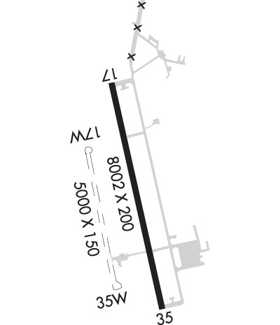
| Lat: N 3002.3 Long: W 09153.0 Elev: 24 Var: -00 Longest Runway: 8002 | ||
| Clr Del: 118.05/121.7 AWOS: 133.32 Ground: 121.7 Tower: 125.0 | ||
| ||||||||||||||||||||||||||||||||||||||||||||
| ||||||||||||||||||||||||||||||||||||||||||||
| ||||||||||||||||||||||||||||||||||||||||||||
| Rwy | Rwy | |||||||
| 8002x200 | 8002' | 8002x200 | 8002' | 108.90 - 347° | ||||
| 5000x150 | 5000' | 5000x150 | 5000' | |||||
| Runway ID | Single Wheel | Double Wheel | Double Tandem Wheel | Dual Double Wheel |
| 17/35 | N/A | 105,000 | 163,000 | 400,000 |
| 17W/35W | N/A | N/A | N/A | N/A |
| H1 | N/A | N/A | N/A | N/A |
| These numbers are Advisory and are not limits. The Airport Manager should have more accurate Weight Limits | ||||
 Airport Diagram might not be current. | |
| Facility Name: | ACADIANA RGNL |
| City Name: | NEW IBERIA |
| County: | IBERIA |
| State abbrev: | LA |
| State Name: | LOUISIANA |
| Ownership: | PUBLICLY OWNED |
| Use: | OPEN TO THE PUBLIC |
| Owner's Name: | IBERIA PARISH GOVERMENT |
| Address: | 300 IBERIA ST |
| NEW IBERIA, LA 70560 | |
| Owner's Phone: | 337-365-8246 |
| Manager's Name: | MAURICE SONGY |
| Address: | 1404 HANGAR DR |
| NEW IBERIA, LA 70560 | |
| Phone: | (337) 365-7202 |
| FAA Region: | SOUTHWEST |
| FAA Field Office: | LNM |

| Date | Sunrise | Sunset |
|---|---|---|
| 06/08/26 Monday | 6:06 | 20:07 |
| 06/09/26 Tuesday | 6:06 | 20:08 |
| 06/10/26 Wednesday | 6:06 | 20:08 |
| 06/11/26 Thursday | 6:06 | 20:09 |
| 06/12/26 Friday | 6:06 | 20:09 |
| 06/13/26 Saturday | 6:06 | 20:09 |
| 06/14/26 Sunday | 6:06 | 20:10 |
| 06/15/26 Monday | 6:06 | 20:10 |
| 06/16/26 Tuesday | 6:06 | 20:10 |
| 06/17/26 Wednesday | 6:06 | 20:11 |
| 06/18/26 Thursday | 6:06 | 20:11 |
| 06/19/26 Friday | 6:06 | 20:11 |
| 06/20/26 Saturday | 6:07 | 20:12 |
| 06/21/26 Sunday | 6:07 | 20:12 |
| Airport Attendance Schedule | 7 Days A Week 0700-2100 |
| Airport Status | OPERATIONAL (This Status can change at any time - please check NOTAMS) |
| Airport Lighting Schedule | DUSK-DAWN. WHEN ATCT CLSD HIRL RY 17/35 PRESET LOW INTST; TO INCR INTST & ACTVT MALSR RY 35 - CTAF. |
| Airport Storage Available | Tie Downs, Hanger |
| Extra Services Available | Air Freight, Cargo Handling, Flight Instruction |
| Wind Indicator | YES - (lighted) |
| Control Tower | YES |
| CTAF Frequency | 125.000 |
| Unicom Frequency | 122.950 |
| Rotating Beacon Color | WG |
| Segmented Circle | YES |
| Landing Fee | NO |
| Airport Inspected | FEDERAL - performed by FAA AIRPORTS FIELD PERSONNEL |
| Inspection Date | 10/31/2025 |
| Type of Fuel Available | Grade 100LL, JET A (freeze point -40C); -10FOR FUEL AFT HRS CALL 337-367-1401 FAX 337-367-1404. |
| Airframe Repair Service | MINOR |
| Power Plant Repair Service | MINOR |
| Latitude | N3002.3 |
| Longitude | W09153.0 (ESTIMATED) |
| Arpt Elevation | 24ft (SURVEYED) |
| Magnetic Variation | 00E |
| 4 miles NW | of NEW IBERIA |
| Traffic Pattern Altitude | |
| Sectional Chart | HOUSTON |
| Operations (Reported) | Yearly | Avg. Daily |
|---|---|---|
| General Aviation Transient | 0 | 0 |
| General Aviation Local | 0 | 0 |
| Air Taxi | 0 | 0 |
| Commerical | 0 | 0 |
| Commuter | 0 | 0 |
| Military | 0 | 0 |
| Aircraft based on Field | |
|---|---|
| General Aviation Singles | 0 |
| General Aviation Multi | 0 |
| Jet Aircraft | 0 |
| General Aviation Helicopters | 0 |
| Military Aircraft | 0 |
| Gliders | 0 |
| Ultralights | 0 |
| FSS on field | NO |
| FSS tie-in | DE RIDDER |
| FSS Phone | 1-800-WX-BRIEF |
| Who issues Notams | ARA |
| Notam D service at airport | YES |
| ARTCC Name | HOUSTON |
| Airport Certification | PPR FOR MORE THAN 30 PSGR SEATS CALL AMGR 337-365-7202 (M-F 0830-1630). |
| Aircraft Rescue & Firefighting Index | AIRPORT HAS A CERTIFICATE UNDER CFR PART 139 |
| Airport of Entry | No |
| Custom Landing Rights | YES |
| Joint Civil/Military | No |
| Military Landing rights | YES |
| NATIONAL PLAN OF INTEGRATED AIRPORT SYSTEMS (NPIAS) |
| GRANT AGREEMENTS UNDER FAAP/ADAP/AIP |
| SURPLUS PROPERTY AGREEMENT UNDER PUBLIC LAW 289 |
| ASSURANCES PURSUANT TO TITLE VI, CIVIL RIGHTS ACT OF 1964 |
| AGREEMENT UNDER DLAND OR DCLA HAS EXPIRED. |
| THIS AIRPORT HAS BEEN SURVEYED BY THE NATIONAL GEODETIC SURVEY. |
| ROTOR WING MOVEMENT AND LANDING AREA BETWEEN THE RY AND SEAWAY. |
| CTC APRT MGR FOR DSGND RAMP SPACE FOR PUB USE. |
| INTENSIVE HELO TRAINING. |
| SEAPLANE LNDG AREA (WATER CHANNEL) NOT AVBL / PERM CLSD |
| BIRD ACTIVITY ON & INVOF ARPT. |
| COMPASS ROSE NOT AVBL. |
| FOR CD WHEN APCH CLSD CTC HOUSTON ARTCC AT 281-230-5622. |
| ARFF INDEX B BTN 1200Z AND 0830Z MON THRU FRI. ANY ADDITIONAL REQUIRES 24 PPR. |
| NO OVERNIGHT CAMPING. |
| RWY 17/3 5 PCR VALUE: 500/R/B/W/T |
Airport Communications & Frequencies:
| |||||||||||||||||||||||||||||
| Runway: 17 | Runway: 35 | ||
| Mag heading: | 168° | Mag heading: | 348° |
| Rwy Slope: | -.06% Down | Rwy Slope: | .06% Up |
| Approach: | Approach: | ILS/DME | |
| Pattern: | Left Traffic | Pattern: | Right Traffic |
| Markings: | PRECISION INSTRUMENT | Markings: | PRECISION INSTRUMENT |
| Marking Condition: | GOOD | Marking Condition: | GOOD |
| Arresting Dev: | Arresting Dev: | ||
| Lat & Long: | N3002.9 W09153.2 | Lat. & Long.: | N3001.6 W09152.9 |
| Elev: | 24.0 ft. MSL | Elev: | 18.8 ft. MSL |
| TCH: | 51 ft. AGL | TCH: | 52 ft. AGL |
| Visual Glide Path: | 3.00 degrees | Visual Glide Path: | 3.00 degrees |
| Displaced Threshold: | No | Displaced Threshold: | No |
| Touchdown Zone: | YES | Touchdown Zone: | YES |
| Touchdown Elev.: | 24.0 feet | Touchdown Elev.: | 20.8 feet |
| Visual Glide Slope: | 4-Light PAPI on LEFT side of Runway | Visual Glide Slope: | 4-Light PAPI on LEFT side of Runway |
| RVR Equipment: | RVR Equipment: | ||
| RVV Equipment: | NO | RVV Equipment: | NO |
| Approach Lights: | ODALS - omnidirectional approach lighting system | Approach Lights: | MALSR - 1,400 foot medium intensity approach lighting system with runway alignment indicator lights |
| REIL: | NO | REIL: | NO |
| Centerline Lights: | NO | Centerline Lights: | NO |
| Touchdown lights: | NO | Touchdown lights: | NO |
| Runway Category: | Runway with a Non-precision Approach having visibility minimums greater than 3/4 mile | Runway Category: | Precision Instrument Runway |
| Declared Distances: | TORA:8002' TODA:8002' ASDA:8002' LDA:8002' | Declared Distances: | TORA:8002' TODA:8002' ASDA:8002' LDA:8002' |
| Runway: 17W | Runway: 35W | ||
| Mag heading: | 168° | Mag heading: | 348° |
| Rwy Slope: | .00% Down | Rwy Slope: | .00% Up |
| Approach: | Approach: | ||
| Pattern: | Right Traffic | Pattern: | Left Traffic |
| Markings: | NONSTANDARD | Markings: | NONSTANDARD |
| Marking Condition: | Marking Condition: | ||
| Arresting Dev: | Arresting Dev: | ||
| Lat & Long: | N3002.5 W09153.4 | Lat. & Long.: | N3001.7 W09153.2 |
| Elev: | 20.3 ft. MSL | Elev: | 20.2 ft. MSL |
| TCH: | TCH: | ||
| Visual Glide Path: | Visual Glide Path: | ||
| Displaced Threshold: | No | Displaced Threshold: | No |
| Touchdown Zone: | NO | Touchdown Zone: | NO |
| Touchdown Elev.: | Touchdown Elev.: | ||
| Visual Glide Slope: | Visual Glide Slope: | ||
| RVR Equipment: | RVR Equipment: | ||
| RVV Equipment: | NO | RVV Equipment: | NO |
| Approach Lights: | Approach Lights: | ||
| REIL: | NO | REIL: | NO |
| Centerline Lights: | NO | Centerline Lights: | NO |
| Touchdown lights: | NO | Touchdown lights: | NO |
| Runway Category: | Runway with a Visual Approach | Runway Category: | Runway with a Visual Approach |
| Declared Distances: | TORA:5000' TODA:5000' ASDA:5000' LDA:5000' | Declared Distances: | TORA:5000' TODA:5000' ASDA:5000' LDA:5000' |
Thanks for using FltPlan.com
all rights reserved © 1999-2026 by Flight Plan LLC