
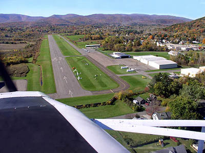
| HARRIMAN-AND-WEST NORTH ADAMS MA |
| |
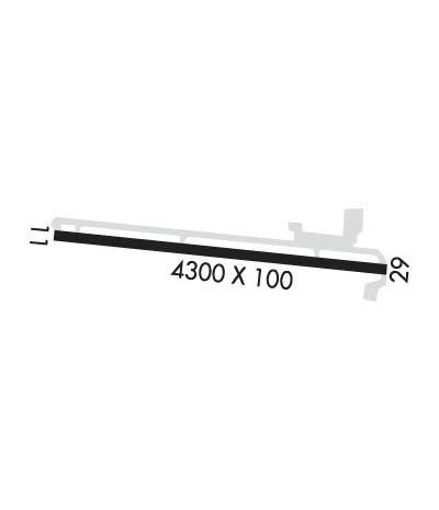
| Lat: N 4241.8 Long: W 07310.2 Elev: 654 Var: +14 Longest Runway: 4300 | ||
| AWOS: 134.77 CTAF: 122.8 | ||
| ||||||||||||||||||||||||||||||||||||||||||||
| ||||||||||||||||||||||||||||||||||||||||||||
| ||||||||||||||||||||||||||||||||||||||||||||
| ||||||||||||||||||||||||||||||||||||||||||||
| Rwy | Rwy | |||||||
| 4300x100 | 3800' | 4300x100 | 4200' | |||||
| Runway ID | Single Wheel | Double Wheel | Double Tandem Wheel | Dual Double Wheel |
| 11/29 | 25,000 | N/A | N/A | N/A |
| These numbers are Advisory and are not limits. The Airport Manager should have more accurate Weight Limits | ||||
 Airport Diagram might not be current. | |
| Facility Name: | HARRIMAN-AND-WEST |
| City Name: | NORTH ADAMS |
| County: | BERKSHIRE |
| State abbrev: | MA |
| State Name: | MASSACHUSETTS |
| Ownership: | PUBLICLY OWNED |
| Use: | OPEN TO THE PUBLIC |
| Owner's Name: | CITY OF NORTH ADAMS |
| Address: | 10 MAIN ST - CITY HALL |
| NORTH ADAMS, MA 01247 | |
| Owner's Phone: | 413-662-3000 |
| Manager's Name: | ANDREW FRANKLIN |
| Address: | 10 MAIN ST - CITY HALL |
| NORTH ADAMS, MA 01247 | |
| Phone: | 413-652-7735 |
| FAA Region: | NEW ENGLAND |
| FAA Field Office: | NONE |
| Date | Sunrise | Sunset |
|---|---|---|
| 06/07/26 Sunday | 5:15 | 20:28 |
| 06/08/26 Monday | 5:15 | 20:29 |
| 06/09/26 Tuesday | 5:15 | 20:29 |
| 06/10/26 Wednesday | 5:14 | 20:30 |
| 06/11/26 Thursday | 5:14 | 20:30 |
| 06/12/26 Friday | 5:14 | 20:31 |
| 06/13/26 Saturday | 5:14 | 20:31 |
| 06/14/26 Sunday | 5:14 | 20:32 |
| 06/15/26 Monday | 5:14 | 20:32 |
| 06/16/26 Tuesday | 5:14 | 20:33 |
| 06/17/26 Wednesday | 5:14 | 20:33 |
| 06/18/26 Thursday | 5:14 | 20:33 |
| 06/19/26 Friday | 5:14 | 20:34 |
| 06/20/26 Saturday | 5:14 | 20:34 |
| Airport Attendance Schedule | 7 Days A Week IREG |
| Airport Status | OPERATIONAL (This Status can change at any time - please check NOTAMS) |
| Airport Lighting Schedule | ACTVT MIRL RWY 11/29 - CTAF. |
| Airport Storage Available | Tie Downs |
| Extra Services Available | Avionics, Glider, Aircraft Rental, Annual Surveying, Glider Towing |
| Wind Indicator | YES - (lighted) |
| Control Tower | NO |
| CTAF Frequency | 122.800 |
| Unicom Frequency | 122.800 |
| Rotating Beacon Color | WG |
| Segmented Circle | NO |
| Landing Fee | YES; CTC AMGR FOR LNDG FEES. |
| Airport Inspected | STATE - performed by STATE AERONAUTICAL PERSONNEL |
| Inspection Date | 07/17/2025 |
| Type of Fuel Available | Grade 100LL, JET A (freeze point -40C) |
| Airframe Repair Service | MAJOR |
| Power Plant Repair Service | MAJOR |
| Latitude | N4241.8 |
| Longitude | W07310.2 (ESTIMATED) |
| Arpt Elevation | 653ft (SURVEYED) |
| Magnetic Variation | 14W |
| 3 miles W | of NORTH ADAMS |
| Traffic Pattern Altitude | |
| Sectional Chart | NEW YORK |
| Operations (Reported) | Yearly | Avg. Daily |
|---|---|---|
| General Aviation Transient | 0 | 0 |
| General Aviation Local | 0 | 0 |
| Air Taxi | 0 | 0 |
| Commerical | 0 | 0 |
| Commuter | 0 | 0 |
| Military | 0 | 0 |
| Aircraft based on Field | |
|---|---|
| General Aviation Singles | 0 |
| General Aviation Multi | 0 |
| Jet Aircraft | 0 |
| General Aviation Helicopters | 0 |
| Military Aircraft | 0 |
| Gliders | 0 |
| Ultralights | 0 |
| FSS on field | NO |
| FSS tie-in | BURLINGTON |
| FSS Phone | 1-800-WX-BRIEF |
| Who issues Notams | AQW |
| Notam D service at airport | YES |
| ARTCC Name | BOSTON |
| Airport Certification | |
| Aircraft Rescue & Firefighting Index | None |
| Airport of Entry | No |
| Custom Landing Rights | No |
| Joint Civil/Military | No |
| Military Landing rights | YES |
| NATIONAL PLAN OF INTEGRATED AIRPORT SYSTEMS (NPIAS) |
| GRANT AGREEMENTS UNDER FAAP/ADAP/AIP |
| ASSURANCES PURSUANT TO TITLE VI, CIVIL RIGHTS ACT OF 1964 |
| MT RANGES 9100 FT N AT ELEV 1894 FT; 4300 FT N AT ELEV 2254 FT; 10800 FT S AT ELEV 2951 FT; 12800 FT S AT ELEV 2690 FT. |
| RWY 11 LEFT TFC FOR PWRD ACFT. RWY 11 RIGHT TFC FOR GLD AND TOW PLANE. |
| EXTSV GLDR OPS DAWN-DUSK SFC-18000 FT YEAR ROUND; PRIMARILY WKENDS & HOLS. |
| RWY 29 RIGHT TFC FOR PWRD ACFT. RWY 29 LEFT TFC FOR GLD AND TOW PLANE. |
| WILDLIFE ON & INVOF ARPT. |
| FOR CD CTC ALBANY APCH AT 518-862-2299. |
| TWY A2 REMOVED. |
| PILOTS LDG ON RWY 29 ARE ENCOURAGED TO AVOID LOW APCHS, IF SAFE TO DO SO, OVR THE RES NBRHD JUST E OF THE ARPT. |
Airport Communications & Frequencies:
| |||||||||||||||||
| Runway: 11 | Runway: 29 | ||
| Mag heading: | 111° | Mag heading: | 291° |
| Rwy Slope: | .04% Up | Rwy Slope: | -.04% Down |
| Approach: | Approach: | ||
| Pattern: | Left Traffic | Pattern: | Right Traffic |
| Markings: | BASIC | Markings: | BASIC |
| Marking Condition: | GOOD | Marking Condition: | GOOD |
| Arresting Dev: | Arresting Dev: | ||
| Lat & Long: | N4241.8 W07310.7 | Lat. & Long.: | N4241.7 W07309.8 |
| Elev: | 652.0 ft. MSL | Elev: | 653.8 ft. MSL |
| TCH: | TCH: | ||
| Visual Glide Path: | Visual Glide Path: | ||
| Displaced Threshold: | 500 feet | Displaced Threshold: | 100 feet |
| Touchdown Zone: | YES | Touchdown Zone: | YES |
| Touchdown Elev.: | 652.2 feet | Touchdown Elev.: | 653.4 feet |
| Visual Glide Slope: | Visual Glide Slope: | ||
| RVR Equipment: | RVR Equipment: | ||
| RVV Equipment: | NO | RVV Equipment: | NO |
| Approach Lights: | Approach Lights: | ||
| REIL: | NO | REIL: | NO |
| Centerline Lights: | NO | Centerline Lights: | NO |
| Touchdown lights: | NO | Touchdown lights: | NO |
| Runway Category: | Runway with a Visual Approach | Runway Category: | Runway with a Visual Approach |
| Declared Distances: | Declared Distances: | ||
| Obstructions: | TREES | Obstructions: | BLDG |
| Marked: | NOT Marked/Lighted | Marked: | NOT Marked/Lighted |
| Clearance slope: | 11:1; APCH RATIO 20:1 TO DTHR. | Clearance slope: | 6:1; APCH RATIO 20:1 TO DTHR. |
| Obstruction height: | 62 feet AGL | Obstruction height: | 25 feet AGL |
| Dist. from runway: | 920 feet | Dist. from runway: | 340 feet |
| Centerline offset: | 80 left of centerline | Centerline offset: | 130 feet right of centerline |
| Comments: | Comments: |
Thanks for using FltPlan.com
all rights reserved © 1999-2026 by Flight Plan LLC