
| APPLETON MUNI APPLETON MN |
| |
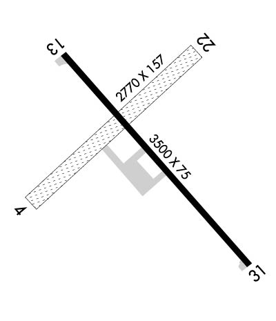
| Lat: N 4513.7 Long: W 09600.3 Elev: 1021 Var: -05 Longest Runway: 3500 | ||
| AWOS: 356K CTAF: 122.9 | ||
| ||||||||||||||||||||||||||||||||
| ||||||||||||||||||||||||||||||||
| ||||||||||||||||||||||||||||||||
| Rwy | Rwy | |||||||
| 2770x157 | 2770' | 2770x157 | 2770' | |||||
| 3500x75 | 3500' | 3500x75 | 3500' | |||||
| Runway ID | Single Wheel | Double Wheel | Double Tandem Wheel | Dual Double Wheel |
| 04/22 | N/A | N/A | N/A | N/A |
| 13/31 | N/A | N/A | N/A | N/A |
| These numbers are Advisory and are not limits. The Airport Manager should have more accurate Weight Limits | ||||
 Airport Diagram might not be current. | |
| Facility Name: | APPLETON MUNI |
| City Name: | APPLETON |
| County: | SWIFT |
| State abbrev: | MN |
| State Name: | MINNESOTA |
| Ownership: | PUBLICLY OWNED |
| Use: | OPEN TO THE PUBLIC |
| Owner's Name: | CITY OF APPLETON |
| Address: | 323 W. SCHLIEMAN AVE. |
| APPLETON, MN 56208 | |
| Owner's Phone: | 320-289-1363 |
| Manager's Name: | GREG RUETHER |
| Address: | 149 S MUNSTERMAN |
| APPLETON, MN 56208 | |
| Phone: | (320) 413-0089 |
| FAA Region: | GREAT LAKES |
| FAA Field Office: | DMA |
| Date | Sunrise | Sunset |
|---|---|---|
| 09/24/21 Friday | 7:13 | 19:18 |
| 09/25/21 Saturday | 7:14 | 19:16 |
| 09/26/21 Sunday | 7:16 | 19:14 |
| 09/27/21 Monday | 7:17 | 19:12 |
| 09/28/21 Tuesday | 7:18 | 19:10 |
| 09/29/21 Wednesday | 7:19 | 19:09 |
| 09/30/21 Thursday | 7:21 | 19:07 |
| 10/01/21 Friday | 7:22 | 19:05 |
| 10/02/21 Saturday | 7:23 | 19:03 |
| 10/03/21 Sunday | 7:24 | 19:01 |
| 10/04/21 Monday | 7:26 | 18:59 |
| 10/05/21 Tuesday | 7:27 | 18:57 |
| 10/06/21 Wednesday | 7:28 | 18:55 |
| 10/07/21 Thursday | 7:29 | 18:54 |
| Airport Attendance Schedule | UNATTENDED |
| Airport Status | OPERATIONAL (This Status can change at any time - please check NOTAMS) |
| Airport Lighting Schedule | ACTVT MIRL RY 13/31 - CTAF. |
| Airport Storage Available | Tie Downs |
| Extra Services Available | Aircraft Sales |
| Wind Indicator | YES - (lighted) |
| Control Tower | NO |
| CTAF Frequency | 122.900 |
| Unicom Frequency | |
| Rotating Beacon Color | CLEAR-GREEN (Light Land Airport) |
| Segmented Circle | NO |
| Landing Fee | NO |
| Airport Inspected | STATE - performed by STATE AERONAUTICAL PERSONNEL |
| Inspection Date | 11/04/2020 |
| Type of Fuel Available | None |
| Airframe Repair Service | NONE |
| Power Plant Repair Service | NONE |
| Latitude | N4513.7 |
| Longitude | W09600.3 (ESTIMATED) |
| Arpt Elevation | 1021ft (SURVEYED) |
| Magnetic Variation | 05E |
| 2 miles NE | of APPLETON |
| Traffic Pattern Altitude | |
| Sectional Chart | TWIN CITIES |
| Operations (Reported) | Yearly | Avg. Daily |
|---|---|---|
| General Aviation Transient | 400 | 1 |
| General Aviation Local | 2000 | 5 |
| Air Taxi | 0 | 0 |
| Commerical | 0 | 0 |
| Commuter | 0 | 0 |
| Military | 0 | 0 |
| Aircraft based on Field | |
|---|---|
| General Aviation Singles | 12 |
| General Aviation Multi | 0 |
| Jet Aircraft | 0 |
| General Aviation Helicopters | 0 |
| Military Aircraft | 0 |
| Gliders | 0 |
| Ultralights | 0 |
| FSS on field | NO |
| FSS tie-in | PRINCETON |
| FSS Phone | 1-800-WX-BRIEF |
| Who issues Notams | AQP |
| Notam D service at airport | YES |
| ARTCC Name | MINNEAPOLIS |
| Airport Certification | |
| Aircraft Rescue & Firefighting Index | None |
| Airport of Entry | No |
| Custom Landing Rights | No |
| Joint Civil/Military | No |
| Military Landing rights | No |
| FOR CD CTC MINNEAPOLIS ARTCC AT 651-463-5588. |
| RWY 04/2 2 CLOSED WINTER MONTHS. |
| RWY 13/3 1 CRACKING. |
| RWY 13/3 1 RY 13 VISUAL LIGHTING ON INSTRUMENT RY. |
Airport Communications & Frequencies:
| |||||||
| Runway: 04 | Runway: 22 | ||
| Mag heading: | 40° | Mag heading: | 220° |
| Rwy Slope: | .07% Up | Rwy Slope: | -.07% Down |
| Approach: | Approach: | ||
| Pattern: | Left Traffic | Pattern: | Left Traffic |
| Markings: | NONSTANDARD | Markings: | NONSTANDARD |
| Marking Condition: | FAIR; MKD WITH YELLOW CONES. | Marking Condition: | FAIR; MKD WITH YELLOW CONES. |
| Arresting Dev: | Arresting Dev: | ||
| Lat & Long: | N4513.5 W09600.6 | Lat. & Long.: | N4513.9 W09600.1 |
| Elev: | 1019.0 ft. MSL | Elev: | 1021.0 ft. MSL |
| TCH: | TCH: | ||
| Visual Glide Path: | Visual Glide Path: | ||
| Displaced Threshold: | No | Displaced Threshold: | No |
| Touchdown Zone: | YES | Touchdown Zone: | YES |
| Touchdown Elev.: | 1021.0 feet | Touchdown Elev.: | 1021.0 feet |
| Visual Glide Slope: | Visual Glide Slope: | ||
| RVR Equipment: | RVR Equipment: | ||
| RVV Equipment: | NO | RVV Equipment: | NO |
| Approach Lights: | Approach Lights: | ||
| REIL: | NO | REIL: | NO |
| Centerline Lights: | NO | Centerline Lights: | NO |
| Touchdown lights: | NO | Touchdown lights: | NO |
| Runway Category: | Runway with a Visual Approach | Runway Category: | Runway with a Visual Approach |
| Declared Distances: | Declared Distances: |
| Runway: 13 | Runway: 31 | ||
| Mag heading: | 130° | Mag heading: | 310° |
| Rwy Slope: | -.04% Down | Rwy Slope: | .04% Up |
| Approach: | Approach: | ||
| Pattern: | Left Traffic | Pattern: | Left Traffic |
| Markings: | NONPRECISION INSTRUMENT | Markings: | NONPRECISION INSTRUMENT |
| Marking Condition: | FAIR | Marking Condition: | FAIR |
| Arresting Dev: | Arresting Dev: | ||
| Lat & Long: | N4513.8 W09600.5 | Lat. & Long.: | N4513.4 W09559.9 |
| Elev: | 1020.0 ft. MSL | Elev: | 1018.7 ft. MSL |
| TCH: | TCH: | ||
| Visual Glide Path: | Visual Glide Path: | ||
| Displaced Threshold: | No | Displaced Threshold: | No |
| Touchdown Zone: | YES | Touchdown Zone: | YES |
| Touchdown Elev.: | 1020.2 feet | Touchdown Elev.: | 1020.2 feet |
| Visual Glide Slope: | Visual Glide Slope: | ||
| RVR Equipment: | RVR Equipment: | ||
| RVV Equipment: | NO | RVV Equipment: | NO |
| Approach Lights: | Approach Lights: | ||
| REIL: | NO | REIL: | NO |
| Centerline Lights: | NO | Centerline Lights: | NO |
| Touchdown lights: | NO | Touchdown lights: | NO |
| Runway Category: | Runway with a Non-precision Approach | Runway Category: | Runway with a Visual Approach |
| Declared Distances: | Declared Distances: |
Thanks for using FltPlan.com
all rights reserved © 1999-2021 by Flight Plan LLC
