
| LLANO MUNI LLANO TX |
| |
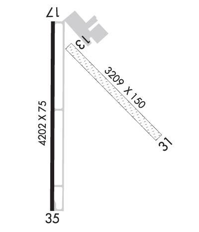
| Lat: N 3047.1 Long: W 09839.6 Elev: 1102 Var: -05 Longest Runway: 4202 | ||
| AWOS: 119.42 CTAF: 123.05 | ||
| ||||||
| ||||||
|
| Rwy | Rwy | |||||||
| 3209x150 | 3209' | 3209x150 | 3209' | |||||
| 4202x75 | 4202' | 4202x75 | 4202' | |||||
| Runway ID | Single Wheel | Double Wheel | Double Tandem Wheel | Dual Double Wheel |
| 13/31 | N/A | N/A | N/A | N/A |
| 17/35 | 20,000 | N/A | N/A | N/A |
| These numbers are Advisory and are not limits. The Airport Manager should have more accurate Weight Limits | ||||
 Airport Diagram might not be current. | |
| Facility Name: | LLANO MUNI |
| City Name: | LLANO |
| County: | LLANO |
| State abbrev: | TX |
| State Name: | TEXAS |
| Ownership: | PUBLICLY OWNED |
| Use: | OPEN TO THE PUBLIC |
| Owner's Name: | CITY OF LLANO |
| Address: | 301 W MAIN |
| LLANO, TX 78643 | |
| Owner's Phone: | 325-247-4158 |
| Manager's Name: | KIRK D. NOAKER, SR. |
| Address: | 100 EVELYN GOULD DRIVE |
| LLANO, TX 78643 | |
| Phone: | 325-247-5635 |
| FAA Region: | SOUTHWEST |
| FAA Field Office: | TEX |
| Date | Sunrise | Sunset |
|---|---|---|
| 06/07/26 Sunday | 6:31 | 20:36 |
| 06/08/26 Monday | 6:31 | 20:36 |
| 06/09/26 Tuesday | 6:31 | 20:37 |
| 06/10/26 Wednesday | 6:31 | 20:37 |
| 06/11/26 Thursday | 6:31 | 20:38 |
| 06/12/26 Friday | 6:31 | 20:38 |
| 06/13/26 Saturday | 6:31 | 20:38 |
| 06/14/26 Sunday | 6:31 | 20:39 |
| 06/15/26 Monday | 6:31 | 20:39 |
| 06/16/26 Tuesday | 6:31 | 20:39 |
| 06/17/26 Wednesday | 6:31 | 20:40 |
| 06/18/26 Thursday | 6:32 | 20:40 |
| 06/19/26 Friday | 6:32 | 20:40 |
| 06/20/26 Saturday | 6:32 | 20:40 |
| Airport Attendance Schedule | FRI-MON 0800-1700, TUE-THU 0700-1700 |
| Airport Status | OPERATIONAL (This Status can change at any time - please check NOTAMS) |
| Airport Lighting Schedule | DUSK-DAWN. MIRL RWY 17/35 PRESET LOW INTST; TO INCR INTST ACTVT - CTAF. |
| Airport Storage Available | Tie Downs, Hanger |
| Extra Services Available | NONE |
| Wind Indicator | YES - (lighted) |
| Control Tower | NO |
| CTAF Frequency | 123.050 |
| Unicom Frequency | 123.050 |
| Rotating Beacon Color | WG |
| Segmented Circle | YES |
| Landing Fee | NO |
| Airport Inspected | STATE - performed by PRIVATE CONTRACT PERSONNEL |
| Inspection Date | 06/09/2023 |
| Type of Fuel Available | Grade 100LL, JET A (freeze point -40C); -10100LL SELF SVC. |
| Airframe Repair Service | MAJOR |
| Power Plant Repair Service | MAJOR |
| Latitude | N3047.1 |
| Longitude | W09839.6 (ESTIMATED) |
| Arpt Elevation | 1101ft (SURVEYED) |
| Magnetic Variation | 05E |
| 2 miles NE | of LLANO |
| Traffic Pattern Altitude | |
| Sectional Chart | SAN ANTONIO |
| Operations (Reported) | Yearly | Avg. Daily |
|---|---|---|
| General Aviation Transient | 0 | 0 |
| General Aviation Local | 0 | 0 |
| Air Taxi | 0 | 0 |
| Commerical | 0 | 0 |
| Commuter | 0 | 0 |
| Military | 0 | 0 |
| Aircraft based on Field | |
|---|---|
| General Aviation Singles | 0 |
| General Aviation Multi | 0 |
| Jet Aircraft | 0 |
| General Aviation Helicopters | 0 |
| Military Aircraft | 0 |
| Gliders | 0 |
| Ultralights | 0 |
| FSS on field | NO |
| FSS tie-in | SAN ANGELO |
| FSS Phone | 1-800-WX-BRIEF |
| Who issues Notams | AQO |
| Notam D service at airport | YES |
| ARTCC Name | HOUSTON |
| Airport Certification | |
| Aircraft Rescue & Firefighting Index | None |
| Airport of Entry | No |
| Custom Landing Rights | No |
| Joint Civil/Military | No |
| Military Landing rights | No |
| NATIONAL PLAN OF INTEGRATED AIRPORT SYSTEMS (NPIAS) |
| DEER ON & INVOF RWY. |
| FOR CD CTC HOUSTON ARTCC AT 281-230-5622. |
Airport Communications & Frequencies:
| |||||||||
| Runway: 13 | Runway: 31 | ||
| Mag heading: | 133° | Mag heading: | 313° |
| Rwy Slope: | -.62% Down | Rwy Slope: | .62% Up |
| Approach: | Approach: | ||
| Pattern: | Left Traffic | Pattern: | Right Traffic |
| Markings: | Markings: | ||
| Marking Condition: | RWY 13/31 THRS MKD WITH WHITE TIRES. | Marking Condition: | |
| Arresting Dev: | Arresting Dev: | ||
| Lat & Long: | N3047.3 W09839.6 | Lat. & Long.: | N3046.9 W09839.2 |
| Elev: | 1096.0 ft. MSL | Elev: | 1076.2 ft. MSL |
| TCH: | TCH: | ||
| Visual Glide Path: | Visual Glide Path: | ||
| Displaced Threshold: | No | Displaced Threshold: | No |
| Touchdown Zone: | YES | Touchdown Zone: | YES |
| Touchdown Elev.: | 1096.0 feet | Touchdown Elev.: | 1094.0 feet |
| Visual Glide Slope: | Visual Glide Slope: | ||
| RVR Equipment: | RVR Equipment: | ||
| RVV Equipment: | NO | RVV Equipment: | NO |
| Approach Lights: | Approach Lights: | ||
| REIL: | NO | REIL: | NO |
| Centerline Lights: | NO | Centerline Lights: | NO |
| Touchdown lights: | NO | Touchdown lights: | NO |
| Runway Category: | Runway with a Visual Approach | Runway Category: | Runway with a Visual Approach |
| Declared Distances: | Declared Distances: | ||
| Obstructions: | Obstructions: | TREES | |
| Marked: | Marked: | NOT Marked/Lighted | |
| Clearance slope: | 50:1 | Clearance slope: | 15:1 |
| Obstruction height: | Obstruction height: | 20 feet AGL | |
| Dist. from runway: | Dist. from runway: | 313 feet | |
| Centerline offset: | Centerline offset: | 120 feet left of centerline | |
| Comments: | Comments: |
| Runway: 17 | Runway: 35 | ||
| Mag heading: | 174° | Mag heading: | 354° |
| Rwy Slope: | .00% Up | Rwy Slope: | .00% Down |
| Approach: | Approach: | ||
| Pattern: | Right Traffic | Pattern: | Left Traffic |
| Markings: | NONPRECISION INSTRUMENT | Markings: | NONPRECISION INSTRUMENT |
| Marking Condition: | GOOD | Marking Condition: | GOOD |
| Arresting Dev: | Arresting Dev: | ||
| Lat & Long: | N3047.4 W09839.7 | Lat. & Long.: | N3046.7 W09839.7 |
| Elev: | 1101.3 ft. MSL | Elev: | 1101.5 ft. MSL |
| TCH: | 40 ft. AGL | TCH: | 40 ft. AGL |
| Visual Glide Path: | 2.75 degrees | Visual Glide Path: | 2.75 degrees |
| Displaced Threshold: | No | Displaced Threshold: | No |
| Touchdown Zone: | YES | Touchdown Zone: | YES |
| Touchdown Elev.: | 1101.7 feet | Touchdown Elev.: | 1101.5 feet |
| Visual Glide Slope: | 2-Light PAPI on LEFT side of Runway | Visual Glide Slope: | 2-Light PAPI on LEFT side of Runway |
| RVR Equipment: | RVR Equipment: | ||
| RVV Equipment: | NO | RVV Equipment: | NO |
| Approach Lights: | Approach Lights: | ||
| REIL: | NO | REIL: | NO |
| Centerline Lights: | NO | Centerline Lights: | NO |
| Touchdown lights: | NO | Touchdown lights: | NO |
| Runway Category: | Runway with a Non-precision Approach having visibility minimums greater than 3/4 mile | Runway Category: | Runway with a Non-precision Approach having visibility minimums greater than 3/4 mile |
| Declared Distances: | Declared Distances: | ||
| Obstructions: | TREES | Obstructions: | BRUSH |
| Marked: | NOT Marked/Lighted | Marked: | NOT Marked/Lighted |
| Clearance slope: | 10:1 | Clearance slope: | 5:1 |
| Obstruction height: | 25 feet AGL | Obstruction height: | 15 feet AGL |
| Dist. from runway: | 470 feet | Dist. from runway: | 278 feet |
| Centerline offset: | 295 right of centerline | Centerline offset: | 80 feet right of centerline |
| Comments: | Comments: | 12 FT BRUSH, 50-199 FT DSTC. |
Thanks for using FltPlan.com
all rights reserved © 1999-2026 by Flight Plan LLC