
| APPLE VALLEY APPLE VALLEY CA |
| |
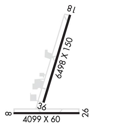
| Lat: N 3434.5 Long: W 11711.2 Elev: 3062 Var: -14 Longest Runway: 6498 | ||
| CTAF: 122.8 | ||
| ||||||
|
| Rwy | Rwy | |||||||
| 4099x60 | 4099' | 4099x60 | 4099' | |||||
| 6498x150 | 6498' | 6498x150 | 5901' | |||||
| Runway ID | Single Wheel | Double Wheel | Double Tandem Wheel | Dual Double Wheel |
| 08/26 | 40,000 | 60,000 | 100,000 | N/A |
| 18/36 | 70,000 | 90,000 | 150,000 | N/A |
| These numbers are Advisory and are not limits. The Airport Manager should have more accurate Weight Limits | ||||
 Airport Diagram might not be current. | |
| Facility Name: | APPLE VALLEY |
| City Name: | APPLE VALLEY |
| County: | SAN BERNARDINO |
| State abbrev: | CA |
| State Name: | CALIFORNIA |
| Ownership: | PUBLICLY OWNED |
| Use: | OPEN TO THE PUBLIC |
| Owner's Name: | COUNTY OF SAN BERNARDINO |
| Address: | 777 EAST RIALTO |
| SAN BERNARDINO, CA 92415 | |
| Owner's Phone: | 909-387-8810 |
| Manager's Name: | INTERIM CTC: MAUREEN SNELGROVE, SAN BERNARDINO CO ASST DIR OF ARPTS, 909-855-5709. ADDNL CTC: VINCE CORONA, 760-780-2756. |
| Address: | 21600 CORWIN ROAD |
| APPLE VALLEY, CA 92307 | |
| Phone: | 760-995-8761 |
| FAA Region: | WESTERN-PACIFIC |
| FAA Field Office: | LAX |
| Date | Sunrise | Sunset |
|---|---|---|
| 09/24/21 Friday | 6:38 | 18:43 |
| 09/25/21 Saturday | 6:39 | 18:41 |
| 09/26/21 Sunday | 6:40 | 18:40 |
| 09/27/21 Monday | 6:40 | 18:39 |
| 09/28/21 Tuesday | 6:41 | 18:37 |
| 09/29/21 Wednesday | 6:42 | 18:36 |
| 09/30/21 Thursday | 6:42 | 18:34 |
| 10/01/21 Friday | 6:43 | 18:33 |
| 10/02/21 Saturday | 6:44 | 18:32 |
| 10/03/21 Sunday | 6:45 | 18:30 |
| 10/04/21 Monday | 6:46 | 18:29 |
| 10/05/21 Tuesday | 6:46 | 18:28 |
| 10/06/21 Wednesday | 6:47 | 18:26 |
| 10/07/21 Thursday | 6:48 | 18:25 |
| Airport Attendance Schedule | 7 Days A Week 0800-1700 |
| Airport Status | OPERATIONAL (This Status can change at any time - please check NOTAMS) |
| Airport Lighting Schedule | ACTVT MIRL RWY 18/36 & TWY LGTS - CTAF. PAPI RWY 18 & 36 ON CONSLY. |
| Airport Storage Available | Tie Downs |
| Extra Services Available | Avionics, Charter, Flight Instruction, Aircraft Rental |
| Wind Indicator | YES - (lighted) |
| Control Tower | NO |
| CTAF Frequency | 122.800 |
| Unicom Frequency | 122.800; AUTOMATED UNICOM; 3 CLICKS ADZY, 4 CLICKS RADIO CHECK. |
| Rotating Beacon Color | CLEAR-GREEN (Light Land Airport) |
| Segmented Circle | YES |
| Landing Fee | NO |
| Airport Inspected | STATE - performed by STATE AERONAUTICAL PERSONNEL |
| Inspection Date | 10/31/2016 |
| Type of Fuel Available | Grade 100LL, JET A (freeze point -40C); -10FUEL AVBL 24 HRS CALL 760-617-7599. |
| Airframe Repair Service | MAJOR |
| Power Plant Repair Service | MAJOR |
| Latitude | N3434.5 |
| Longitude | W11711.2 (ESTIMATED) |
| Arpt Elevation | 3061ft (SURVEYED) |
| Magnetic Variation | 14E |
| 3 miles N | of APPLE VALLEY |
| Traffic Pattern Altitude | TPA RWY 18/36 1000 FT AGL; RWY 08/26 800 FT AGL. |
| Sectional Chart | LOS ANGELES |
| Operations (Reported) | Yearly | Avg. Daily |
|---|---|---|
| General Aviation Transient | 12500 | 34 |
| General Aviation Local | 25000 | 68 |
| Air Taxi | 0 | 0 |
| Commerical | 0 | 0 |
| Commuter | 0 | 0 |
| Military | 0 | 0 |
| Aircraft based on Field | |
|---|---|
| General Aviation Singles | 93 |
| General Aviation Multi | 5 |
| Jet Aircraft | 1 |
| General Aviation Helicopters | 2 |
| Military Aircraft | 0 |
| Gliders | 0 |
| Ultralights | 0 |
| FSS on field | NO |
| FSS tie-in | RIVERSIDE |
| FSS Phone | 1-800-WX-BRIEF |
| Who issues Notams | RAL |
| Notam D service at airport | YES |
| ARTCC Name | LOS ANGELES |
| Airport Certification | |
| Aircraft Rescue & Firefighting Index | None |
| Airport of Entry | No |
| Custom Landing Rights | No |
| Joint Civil/Military | No |
| Military Landing rights | YES |
| NATIONAL PLAN OF INTEGRATED AIRPORT SYSTEMS (NPIAS) |
| GRANT AGREEMENTS UNDER FAAP/ADAP/AIP |
| ASSURANCES PURSUANT TO TITLE VI, CIVIL RIGHTS ACT OF 1964 |
| THIS AIRPORT HAS BEEN SURVEYED BY THE NATIONAL GEODETIC SURVEY. |
| HILLS NE; E; W AND N. |
| RY 18/36 LGTD DSTC REMAINING MKRS EAST SIDE OF RY. |
| ON APCH TO RY 36 CROSS RY 08/26. |
| RY 08/26 CLSD TO ACFT OVER 12500 LBS WITHOUT PPR FM AMGR CALL (760) 247-2371. |
| AEROBATIC TRAINING NE AREA OF ARPT. |
| RWY 08/2 6 RWY 08/26 CLSD TO NIGHT OPNS DUE TO RAPIDLY RISING TERRAIN EAST AND WEST OF RY; WEST TO 3890 FT WITHIN 1.5 NM AND EAST TO 3910 FT WITHIN 1.7 NM. |
Airport Communications & Frequencies:
| |||||||||||||||||
| Runway: 08 | Runway: 26 | ||
| Mag heading: | 76° | Mag heading: | 256° |
| Rwy Slope: | .44% Up | Rwy Slope: | -.44% Down |
| Approach: | Approach: | ||
| Pattern: | Right Traffic | Pattern: | Left Traffic |
| Markings: | BASIC | Markings: | BASIC |
| Marking Condition: | GOOD | Marking Condition: | GOOD |
| Arresting Dev: | Arresting Dev: | ||
| Lat & Long: | N3434.2 W11711.6 | Lat. & Long.: | N3434.2 W11710.8 |
| Elev: | 2957.7 ft. MSL | Elev: | 2975.6 ft. MSL |
| TCH: | TCH: | ||
| Visual Glide Path: | Visual Glide Path: | ||
| Displaced Threshold: | No | Displaced Threshold: | No |
| Touchdown Zone: | YES | Touchdown Zone: | YES |
| Touchdown Elev.: | 2966.9 feet | Touchdown Elev.: | 2975.6 feet |
| Visual Glide Slope: | Visual Glide Slope: | ||
| RVR Equipment: | RVR Equipment: | ||
| RVV Equipment: | NO | RVV Equipment: | NO |
| Approach Lights: | Approach Lights: | ||
| REIL: | NO | REIL: | NO |
| Centerline Lights: | NO | Centerline Lights: | NO |
| Touchdown lights: | NO | Touchdown lights: | NO |
| Runway Category: | Runway with a Visual Approach | Runway Category: | Runway with a Visual Approach |
| Declared Distances: | Declared Distances: | ||
| Obstructions: | PLINE | Obstructions: | |
| Marked: | NOT Marked/Lighted | Marked: | |
| Clearance slope: | 34:1 | Clearance slope: | 50:1 |
| Obstruction height: | 40 feet AGL | Obstruction height: | |
| Dist. from runway: | 1540 feet | Dist. from runway: | |
| Centerline offset: | 212 left of centerline | Centerline offset: | |
| Comments: | Comments: |
| Runway: 18 | Runway: 36 | ||
| Mag heading: | 182° | Mag heading: | 2° |
| Rwy Slope: | -1.47% Down | Rwy Slope: | 1.47% Up |
| Approach: | Approach: | ||
| Pattern: | Left Traffic | Pattern: | Right Traffic |
| Markings: | BASIC | Markings: | BASIC |
| Marking Condition: | GOOD | Marking Condition: | GOOD |
| Arresting Dev: | Arresting Dev: | ||
| Lat & Long: | N3435.3 W11711.0 | Lat. & Long.: | N3434.2 W11711.3 |
| Elev: | 3061.7 ft. MSL | Elev: | 2966.1 ft. MSL |
| TCH: | 49 ft. AGL | TCH: | 40 ft. AGL |
| Visual Glide Path: | 3.50 degrees | Visual Glide Path: | 3.00 degrees |
| Displaced Threshold: | No | Displaced Threshold: | 597 feet |
| Touchdown Zone: | YES | Touchdown Zone: | YES |
| Touchdown Elev.: | 3061.7 feet | Touchdown Elev.: | 3018.1 feet |
| Visual Glide Slope: | 2-Light PAPI on LEFT side of Runway | Visual Glide Slope: | 2-Light PAPI on LEFT side of Runway |
| RVR Equipment: | RVR Equipment: | ||
| RVV Equipment: | NO | RVV Equipment: | NO |
| Approach Lights: | Approach Lights: | ||
| REIL: | NO | REIL: | NO |
| Centerline Lights: | NO | Centerline Lights: | NO |
| Touchdown lights: | NO | Touchdown lights: | NO |
| Runway Category: | Runway with a Non-precision Approach having visibility minimums greater than 3/4 mile | Runway Category: | Runway with a Visual Approach |
| Declared Distances: | Declared Distances: | ||
| Obstructions: | HILL | Obstructions: | |
| Marked: | NOT Marked/Lighted | Marked: | |
| Clearance slope: | 30:1 | Clearance slope: | 50:1 |
| Obstruction height: | 10 feet AGL | Obstruction height: | |
| Dist. from runway: | 500 feet | Dist. from runway: | |
| Centerline offset: | 125 right of centerline | Centerline offset: | |
| Comments: | Comments: |
Thanks for using FltPlan.com
all rights reserved © 1999-2021 by Flight Plan LLC
