| MARION COUNTY-BROWN FIELD JASPER TN |
| |
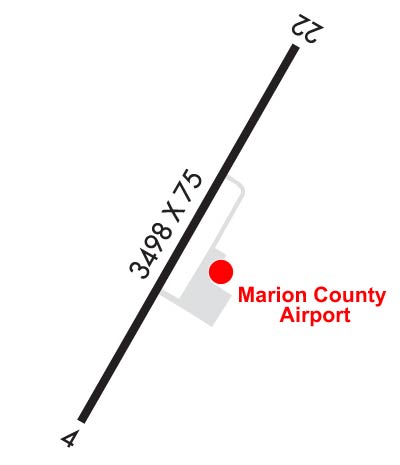
| Lat: N 3503.6 Long: W 08535.1 Elev: 641 Var: +02 Longest Runway: 3498 | ||
| CTAF: 122.8 | ||
| ||||||||||||||||||||||||||||||
| ||||||||||||||||||||||||||||||
| Rwy | Rwy | |||||||
| 3498x75 | 3498' | 3498x75 | 3498' | |||||
| Runway ID | Single Wheel | Double Wheel | Double Tandem Wheel | Dual Double Wheel |
| 04/22 | 30,000 | N/A | N/A | N/A |
| These numbers are Advisory and are not limits. The Airport Manager should have more accurate Weight Limits | ||||
 Airport Diagram might not be current. | |
| Facility Name: | MARION COUNTY-BROWN FLD |
| City Name: | JASPER |
| County: | MARION |
| State abbrev: | TN |
| State Name: | TENNESSEE |
| Ownership: | PUBLICLY OWNED |
| Use: | OPEN TO THE PUBLIC |
| Owner's Name: | MARION COUNTY |
| Address: | 31 COURTHOUSE SQUARE |
| JASPER, TN 37347 | |
| Owner's Phone: | 423-942-2552 |
| Manager's Name: | BETH GUDGER |
| Address: | 300 AIRPORT RD |
| JASPER, TN 37347 | |
| Phone: | 423-942-5234 |
| FAA Region: | SOUTHERN |
| FAA Field Office: | MEM |
| Date | Sunrise | Sunset |
|---|---|---|
| 09/24/21 Friday | 6:32 | 18:37 |
| 09/25/21 Saturday | 6:32 | 18:35 |
| 09/26/21 Sunday | 6:33 | 18:34 |
| 09/27/21 Monday | 6:34 | 18:32 |
| 09/28/21 Tuesday | 6:35 | 18:31 |
| 09/29/21 Wednesday | 6:35 | 18:29 |
| 09/30/21 Thursday | 6:36 | 18:28 |
| 10/01/21 Friday | 6:37 | 18:27 |
| 10/02/21 Saturday | 6:38 | 18:25 |
| 10/03/21 Sunday | 6:38 | 18:24 |
| 10/04/21 Monday | 6:39 | 18:22 |
| 10/05/21 Tuesday | 6:40 | 18:21 |
| 10/06/21 Wednesday | 6:41 | 18:20 |
| 10/07/21 Thursday | 6:42 | 18:18 |
| Airport Attendance Schedule | MON-SAT 0800-1700, SUN 1300-1700; CLSD FED HOLIDAYS. |
| Airport Status | OPERATIONAL (This Status can change at any time - please check NOTAMS) |
| Airport Lighting Schedule | SS-SR |
| Airport Storage Available | Tie Downs, Hanger |
| Extra Services Available | Parachute Jumping |
| Wind Indicator | YES - (unlit) |
| Control Tower | NO |
| CTAF Frequency | 122.800 |
| Unicom Frequency | 122.800 |
| Rotating Beacon Color | CLEAR-GREEN (Light Land Airport) |
| Segmented Circle | YES |
| Landing Fee | NO |
| Airport Inspected | STATE - performed by STATE AERONAUTICAL PERSONNEL |
| Inspection Date | 08/16/2019 |
| Type of Fuel Available | Grade 100LL, JET AMOGAS |
| Airframe Repair Service | NONE |
| Power Plant Repair Service | NONE |
| Latitude | N3503.6 |
| Longitude | W08535.1 (ESTIMATED) |
| Arpt Elevation | 641ft (SURVEYED) |
| Magnetic Variation | 02W |
| 4 miles SE | of JASPER |
| Traffic Pattern Altitude | |
| Sectional Chart | ATLANTA |
| Operations (Reported) | Yearly | Avg. Daily |
|---|---|---|
| General Aviation Transient | 3000 | 8 |
| General Aviation Local | 5200 | 14 |
| Air Taxi | 0 | 0 |
| Commerical | 0 | 0 |
| Commuter | 0 | 0 |
| Military | 200 | 1 |
| Aircraft based on Field | |
|---|---|
| General Aviation Singles | 23 |
| General Aviation Multi | 1 |
| Jet Aircraft | 0 |
| General Aviation Helicopters | 0 |
| Military Aircraft | 0 |
| Gliders | 0 |
| Ultralights | 0 |
| FSS on field | NO |
| FSS tie-in | NASHVILLE |
| FSS Phone | 1-800-WX-BRIEF |
| Who issues Notams | BNA |
| Notam D service at airport | YES |
| ARTCC Name | MEMPHIS |
| Airport Certification | |
| Aircraft Rescue & Firefighting Index | None |
| Airport of Entry | No |
| Custom Landing Rights | No |
| Joint Civil/Military | No |
| Military Landing rights | YES |
| NATIONAL PLAN OF INTEGRATED AIRPORT SYSTEMS (NPIAS) |
| ASSURANCES PURSUANT TO TITLE VI, CIVIL RIGHTS ACT OF 1964 |
| GRANT AGREEMENT HAS EXPIRED; HOWEVER, AGREEMENT REMAINS IN EFFECT FOR THIS FACILITY AS LONG AS IT IS PUBLIC USE. |
| ULTRALIGHT ACT ON AND INVOF ARPT. |
| DEER ON & INVOF ARPT. |
| FOR CD CTC CHATTANOOGA APCH AT 423-855-6478. WHEN APCH CLSD FOR CD CTC MEMPHIS ARTCC AT 901-368-8453/8449. |
Airport Communications & Frequencies:
| |||||||||||||||||
| Runway: 04 | Runway: 22 | ||
| Mag heading: | 40° | Mag heading: | 220° |
| Rwy Slope: | -.01% Down | Rwy Slope: | .01% Up |
| Approach: | Approach: | ||
| Pattern: | Left Traffic | Pattern: | Right Traffic |
| Markings: | NONPRECISION INSTRUMENT | Markings: | NONPRECISION INSTRUMENT |
| Marking Condition: | GOOD | Marking Condition: | GOOD |
| Arresting Dev: | Arresting Dev: | ||
| Lat & Long: | N3503.4 W08535.3 | Lat. & Long.: | N3503.9 W08534.9 |
| Elev: | 641.0 ft. MSL | Elev: | 640.8 ft. MSL |
| TCH: | 26 ft. AGL | TCH: | 26 ft. AGL |
| Visual Glide Path: | 3.50 degrees | Visual Glide Path: | 3.50 degrees |
| Displaced Threshold: | No | Displaced Threshold: | No |
| Touchdown Zone: | YES | Touchdown Zone: | YES |
| Touchdown Elev.: | 641.1 feet | Touchdown Elev.: | 641.1 feet |
| Visual Glide Slope: | 4-Light PAPI on LEFT side of Runway | Visual Glide Slope: | 4-Light PAPI on LEFT side of Runway |
| RVR Equipment: | RVR Equipment: | ||
| RVV Equipment: | NO | RVV Equipment: | NO |
| Approach Lights: | Approach Lights: | ||
| REIL: | YES | REIL: | YES |
| Centerline Lights: | NO | Centerline Lights: | NO |
| Touchdown lights: | NO | Touchdown lights: | NO |
| Runway Category: | Runway with a Non-precision Approach | Runway Category: | Runway with a Visual Approach |
| Declared Distances: | Declared Distances: | ||
| Obstructions: | TREE | Obstructions: | TREE |
| Marked: | NOT Marked/Lighted | Marked: | NOT Marked/Lighted |
| Clearance slope: | 22:1 | Clearance slope: | 24:1 |
| Obstruction height: | 48 feet AGL | Obstruction height: | 75 feet AGL |
| Dist. from runway: | 1253 feet | Dist. from runway: | 1987 feet |
| Centerline offset: | 355 right of centerline | Centerline offset: | 19B |
| Comments: | Comments: |
Thanks for using FltPlan.com
all rights reserved © 1999-2021 by Flight Plan LLC