
| ALPENA COUNTY RGNL ALPENA MI |
| |
| Lat: N 4504.7 Long: W 08333.6 Elev: 690 Var: +07 Longest Runway: 9001 | ||
| AWOS: 120.67 Ground: 121.9 Tower: 121.35 | ||
| ||||||
| ||||||
|
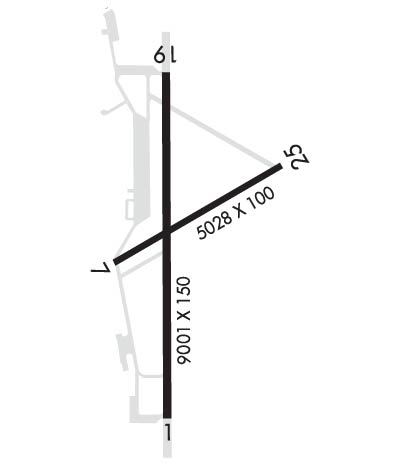
| Rwy | Rwy | |||||||
| 9001x150 | 9001' | 109.70 - 006° | 9001x150 | 9001' | ||||
| 5028x100 | 5028' | 5028x100 | 5028' | |||||
| Runway ID | Single Wheel | Double Wheel | Double Tandem Wheel | Dual Double Wheel |
| 01/19 | 95,000 | 115,000 | 170,000 | 468,000 |
| 07/25 | 93,000 | 111,000 | 170,000 | 438,000 |
| These numbers are Advisory and are not limits. The Airport Manager should have more accurate Weight Limits | ||||
 Airport Diagram might not be current. | |
| Facility Name: | ALPENA COUNTY RGNL |
| City Name: | ALPENA |
| County: | ALPENA |
| State abbrev: | MI |
| State Name: | MICHIGAN |
| Ownership: | PUBLICLY OWNED |
| Use: | OPEN TO THE PUBLIC |
| Owner's Name: | COUNTY OF ALPENA |
| Address: | 1617 AIRPORT RD |
| ALPENA, MI 49707-8213 | |
| Owner's Phone: | 989-354-2907 |
| Manager's Name: | STEVEN SMIGELSKI |
| Address: | 1617 AIRPORT RD |
| ALPENA, MI 49707-8213 | |
| Phone: | 989-354-2907 |
| FAA Region: | GREAT LAKES |
| FAA Field Office: | DET |
| Date | Sunrise | Sunset |
|---|---|---|
| 09/24/21 Friday | 7:23 | 19:28 |
| 09/25/21 Saturday | 7:25 | 19:26 |
| 09/26/21 Sunday | 7:26 | 19:25 |
| 09/27/21 Monday | 7:27 | 19:23 |
| 09/28/21 Tuesday | 7:28 | 19:21 |
| 09/29/21 Wednesday | 7:29 | 19:19 |
| 09/30/21 Thursday | 7:31 | 19:17 |
| 10/01/21 Friday | 7:32 | 19:15 |
| 10/02/21 Saturday | 7:33 | 19:13 |
| 10/03/21 Sunday | 7:34 | 19:11 |
| 10/04/21 Monday | 7:36 | 19:09 |
| 10/05/21 Tuesday | 7:37 | 19:08 |
| 10/06/21 Wednesday | 7:38 | 19:06 |
| 10/07/21 Thursday | 7:39 | 19:04 |
| Airport Attendance Schedule | 7 Days A Week 0500-2300; FOR SER AFT HRS CALL 989-464-1419/989-255-4871. |
| Airport Status | OPERATIONAL (This Status can change at any time - please check NOTAMS) |
| Airport Lighting Schedule | ACTVT MALSR RWY 01; REIL RWY 19, 07, & 25; HIRL RWY 01/19; MIRL RWY 07/25 - CTAF. |
| Airport Storage Available | Tie Downs, Hanger |
| Extra Services Available | Cargo Handling, Charter, Flight Instruction, Aircraft Sales |
| Wind Indicator | YES - (lighted) |
| Control Tower | YES |
| CTAF Frequency | 121.350 |
| Unicom Frequency | 122.950 |
| Rotating Beacon Color | CLEAR-GREEN (Light Land Airport) |
| Segmented Circle | YES |
| Landing Fee | YES |
| Airport Inspected | FEDERAL - performed by FAA AIRPORTS FIELD PERSONNEL |
| Inspection Date | 09/27/2019 |
| Type of Fuel Available | Grade 100LL, JET A (freeze point -40C) |
| Airframe Repair Service | MINOR |
| Power Plant Repair Service | MINOR |
| Latitude | N4504.7 |
| Longitude | W08333.6 (ESTIMATED) |
| Arpt Elevation | 689ft (SURVEYED) |
| Magnetic Variation | 07W |
| 6 miles W | of ALPENA |
| Traffic Pattern Altitude | |
| Sectional Chart | LAKE HURON |
| Operations (Reported) | Yearly | Avg. Daily |
|---|---|---|
| General Aviation Transient | 1130 | 3 |
| General Aviation Local | 7706 | 21 |
| Air Taxi | 0 | 0 |
| Commerical | 1066 | 3 |
| Commuter | 0 | 0 |
| Military | 941 | 3 |
| Aircraft based on Field | |
|---|---|
| General Aviation Singles | 20 |
| General Aviation Multi | 4 |
| Jet Aircraft | 0 |
| General Aviation Helicopters | 0 |
| Military Aircraft | 0 |
| Gliders | 0 |
| Ultralights | 0 |
| FSS on field | NO |
| FSS tie-in | LANSING |
| FSS Phone | 1-800-WX-BRIEF |
| Who issues Notams | APN |
| Notam D service at airport | YES |
| ARTCC Name | MINNEAPOLIS |
| Airport Certification | AIRPORT RECEIVING SCHEDULED AIR CARRIER SERVICE FROM CARRIERS CERTIFICATED BY THE CIVIL AERONAUTICS BOARD |
| Aircraft Rescue & Firefighting Index | AIRPORT HAS A CERTIFICATE UNDER CFR PART 139 |
| Airport of Entry | No |
| Custom Landing Rights | YES |
| Joint Civil/Military | No |
| Military Landing rights | YES |
| NATIONAL PLAN OF INTEGRATED AIRPORT SYSTEMS (NPIAS) |
| GRANT AGREEMENTS UNDER FAAP/ADAP/AIP |
| SURPLUS PROPERTY AGREEMENT UNDER PUBLIC LAW 289 |
| ASSURANCES PURSUANT TO TITLE VI, CIVIL RIGHTS ACT OF 1964 |
| RWY 01 & 19 EACH HAVE 1000 FT OVRN. |
| TWY A WEST OF TWY C & TWY B RSTRD TO MIL ONLY. BE ALERT FOR UNCONTROLLED VEHICLES ON THE TWY. |
| TWY H EAST OF RWY 01/19 UNLGTD. |
| MILITARY: ANG: JOAP SER UNAVBL. |
| FOR CD IF UNA TO CTC ON FSS FREQ, CTC MINNEAPOLIS ARTCC AT 651-463-5588. |
| BIRDS & OTR WILDLIFE ON & INVOF ARPT. |
| MILITARY: SER: FUEL A++. |
| MILITARY: ANG: DUTY HRS 0800-1600 MON-FRI EXC HOLS. |
| RWY 07/2 5 CLSD TO SKEDD ACR OPS GTR THAN 9 PAX SEATS OR UNSKED ACR OPS GTR THAN 30 PAX SEATS. |
| RWY 01/1 9 TRT 560. |
| RWY 07/2 5 TRT 560. |
Airport Communications & Frequencies:
| |||||||||||||||||||||||||||||
| Runway: 01 | Runway: 19 | ||
| Mag heading: | 7° | Mag heading: | 187° |
| Rwy Slope: | .00% Up | Rwy Slope: | .00% Down |
| Approach: | ILS | Approach: | |
| Pattern: | Left Traffic | Pattern: | Left Traffic |
| Markings: | PRECISION INSTRUMENT | Markings: | PRECISION INSTRUMENT |
| Marking Condition: | GOOD | Marking Condition: | GOOD |
| Arresting Dev: | BAK-12,BAK-14; BAK-14 BAK-12A(B) (1500 FT). | Arresting Dev: | BAK-12,BAK-14; BAK-14 BAK-12A(B) (1515 FT). |
| Lat & Long: | N4503.9 W08333.7 | Lat. & Long.: | N4505.4 W08333.7 |
| Elev: | 682.9 ft. MSL | Elev: | 683.0 ft. MSL |
| TCH: | 54 ft. AGL | TCH: | 39 ft. AGL |
| Visual Glide Path: | 3.00 degrees | Visual Glide Path: | 3.00 degrees |
| Displaced Threshold: | No | Displaced Threshold: | No |
| Touchdown Zone: | YES | Touchdown Zone: | YES |
| Touchdown Elev.: | 685.0 feet | Touchdown Elev.: | 683.0 feet |
| Visual Glide Slope: | 4-Light PAPI on LEFT side of Runway | Visual Glide Slope: | 4-Light PAPI on LEFT side of Runway |
| RVR Equipment: | RVR Equipment: | ||
| RVV Equipment: | NO | RVV Equipment: | NO |
| Approach Lights: | MALSR - 1,400 foot medium intensity approach lighting system with runway alignment indicator lights | Approach Lights: | |
| REIL: | NO | REIL: | YES |
| Centerline Lights: | NO | Centerline Lights: | NO |
| Touchdown lights: | NO | Touchdown lights: | NO |
| Runway Category: | Precision Instrument Runway | Runway Category: | D |
| Declared Distances: | TORA:9001' TODA:9001' ASDA:9001' LDA:9001' | Declared Distances: | TORA:9001' TODA:9001' ASDA:9001' LDA:9001' |
| Obstructions: | TREE | Obstructions: | TREE |
| Marked: | NOT Marked/Lighted | Marked: | NOT Marked/Lighted |
| Clearance slope: | 43:1 | Clearance slope: | 35:1 |
| Obstruction height: | 68 feet AGL | Obstruction height: | 56 feet AGL |
| Dist. from runway: | 3190 feet | Dist. from runway: | 2174 feet |
| Centerline offset: | 329 right of centerline | Centerline offset: | 440 feet right of centerline |
| Comments: | Comments: |
| Runway: 07 | Runway: 25 | ||
| Mag heading: | 67° | Mag heading: | 247° |
| Rwy Slope: | -.20% Down | Rwy Slope: | .20% Up |
| Approach: | Approach: | ||
| Pattern: | Left Traffic | Pattern: | Left Traffic |
| Markings: | NONPRECISION INSTRUMENT | Markings: | NONPRECISION INSTRUMENT |
| Marking Condition: | GOOD | Marking Condition: | GOOD |
| Arresting Dev: | Arresting Dev: | ||
| Lat & Long: | N4504.6 W08334.0 | Lat. & Long.: | N4505.0 W08333.0 |
| Elev: | 689.5 ft. MSL | Elev: | 679.6 ft. MSL |
| TCH: | 49 ft. AGL | TCH: | 48 ft. AGL |
| Visual Glide Path: | 3.00 degrees | Visual Glide Path: | 3.00 degrees |
| Displaced Threshold: | No | Displaced Threshold: | No |
| Touchdown Zone: | YES | Touchdown Zone: | YES |
| Touchdown Elev.: | 689.5 feet | Touchdown Elev.: | 681.9 feet |
| Visual Glide Slope: | 4-Light PAPI on LEFT side of Runway | Visual Glide Slope: | 4-Light PAPI on LEFT side of Runway |
| RVR Equipment: | RVR Equipment: | ||
| RVV Equipment: | NO | RVV Equipment: | NO |
| Approach Lights: | Approach Lights: | ||
| REIL: | YES | REIL: | YES |
| Centerline Lights: | NO | Centerline Lights: | NO |
| Touchdown lights: | NO | Touchdown lights: | NO |
| Runway Category: | Runway with a Visual Approach | Runway Category: | Runway with a Visual Approach |
| Declared Distances: | TORA:5031' TODA:5031' ASDA:5031' LDA:5031' | Declared Distances: | TORA:5031' TODA:5031' ASDA:5031' LDA:5031' |
| Obstructions: | TREES | Obstructions: | TREES |
| Marked: | NOT Marked/Lighted | Marked: | NOT Marked/Lighted |
| Clearance slope: | 21:1 | Clearance slope: | 33:1 |
| Obstruction height: | 46 feet AGL | Obstruction height: | 80 feet AGL |
| Dist. from runway: | 1200 feet | Dist. from runway: | 2866 feet |
| Centerline offset: | Centerline offset: | 427 feet left of centerline | |
| Comments: | Comments: |
Thanks for using FltPlan.com
all rights reserved © 1999-2021 by Flight Plan LLC
